


Introduction
In Scotland, only three full-depth avalanches have been recorded definitely (Reference WardWard, 1984[a]), so our knowledge of this type of avalanche is very limited. The main aim of this note is to present data on two full-depth slab avalanches that occurred on 30 December 1982 and 11 April 1984 at the same location on Meall Uaine in Glen Shee, Scotland. Studies by Reference KingKing (unpublished), Reference ShawShaw (unpublished), and Reference WardWard (unpublished) of the geomorphological effect of avalanches in corries and on slopes at high altitudes in Scotland have been inconclusive owing to the absence of direct evidence. The second aim, therefore, is to outline the geomorphic effect of the two avalanches under study. The third aim is to assess the validity of a method, developed by Reference WardWard (unpublished), for forecasting avalanches in Scotland.
The Site
The location of the site (lat. 56°47’ N., long. 3°27’ W.) is illustrated in Figure 1. The site lies at an altitude of approximately 670 m in the south-east-facing basin of Meall Uaine. The slope, which is unconfined, is convex in shape at the line of fracture but concave below this point. In the release zone, the slope has an average angle of 33° and a maximum angle of 35° (measurements made with an Abney level). The vegetation, comprising crowberry (Empetrum sp.), bilberry (Vaccinium myrtillus), cowberry (Vaccinium vitisidaea) and, to a lesser extent, heather (Calluna vulgaris) and Nardus grass (Nardus stricta), reaches a maximum height of approximately 0.15 m. A few boulders are located on the slope. The nearest official weather station (Fig. 1) is at Kindrogan (lat. 56° 45’ N., long. 3° 33’ W.), 7 km to the south-west at an altitude of 259 m (i.e. 411 m below the altitude of the site).
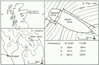
Fig. 1. Location map and plan view of the avalanche site.
Observations
Avalanche characteristics
Figure 1 provides a plan view of the avalanche site and Figures 2 and 3 provide data, recorded at Kindrogan, on wind speed, precipitation, snow depth, and temperature for December 1982 and for January to 11 April 1984, respectively.
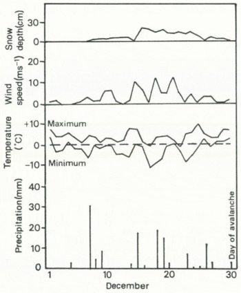
Fig. 2. Precipitation, temperature, snow depth, and wind speed recorded at Kindrogan (259 m) from 1 December 1982 to the avalanche date (30 December 1982).
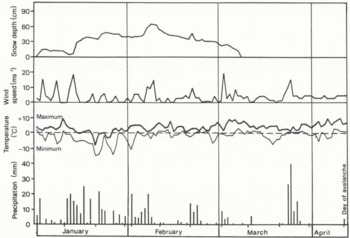
Fig. 3. Precipitation, temperature, snow depth, and wind speed recorded at Kindrogan (259 m) from 1 January 1984 to the avalanche date (11 April 1984).
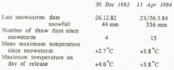
December 1982 was noted for heavy precipitation, falling mostly as snow above c. 600 m, associated with strong winds from the west-south-west and west-north-west (Reference DavisonDavison, 1986). Substantial depths of snow, therefore, accumulated on south-east-facing slopes. After 26 December 1982, there was a sharp thaw with maximum air temperatures reaching 7°C at Kindrogan. In 1984, January and late March were noted for heavy snowfall (Fig. 3); we noted that, above c. 600 m, snow accumulated to unusual depths on east-facing slopes. Maximum air temperatures at Kindrogan, although variable, rose to 10°C after the snowfalls in late March. The classification of the two avalanches is listed in Table I. All dimensions, except the total length of the debris zone (estimated), were measured on site.
Table I. Characteristics of the Two Avalanches, According to the Classification of de Reference Quervain, Quervain, Crécy, LaChapelle, K and ShodaQuervain and Others (1973)
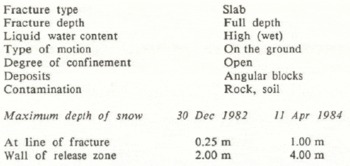
Some characteristics of the snow-pack at the fracture line of the 11 April 1984 avalanche (the first avalanche sparked our interest so, at that time, we were not prepared for taking measurements) are illustrated in Figure 4. The main features of the snow-pack were: (1) wet, soft snow; (2) grain diameters of between 2 and 4 mm; (3) three ice layers; and (4) slush at ground level. The relatively homogeneous stratigraphy, together with ice layers and quite large grain-sizes, suggests that the snow-pack may be a product of several heavy snowfalls, e.g. those in January and late March, interspersed by short periods of thaw (see Fig. 3).
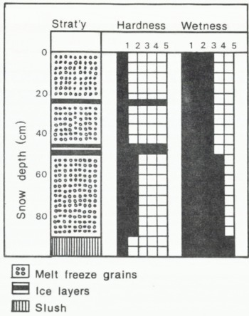
Fig. 4. Characteristics of the snow-pack measured at the fracture line of the 11 April 1984 avalanche. Hardness: 1, fist in; 2, hand in; 3, finger in; 4, pencil in; 5, knife in (Reference Ward, Ward, Langmuir and BeattieWard, 1985). Wetness: 1, no snowball; 2, snowballs formed in hand; 3, hand damp; 4, water squeezed; 5, slush (Reference Ward, Ward, Langmuir and BeattieWard, 1985).
This snow-pack is similar, therefore, to those described by Reference Ward, Ward, Langmuir and BeattieWard (1985) at locations in the Cairngorm Mountains (30 km to the north-west; see Fig. 1). Of particular similarity are the grain-sizes, the stratigraphy, the existence of ice and slush, and the values of hardness and wetness. Whether this snow-pack is unique for the Glen Shee area is not known; previous studies of the characteristics of snow-packs in Scotland have been restricted to sites in the Cairngorm Mountains.
Geomorphological effects
During observation of both avalanches, we noted soil entrained within the snow, so we surveyed the site in the summers of 1983 and 1984 to determine the geomorphological effects of the two avalanches. The main effects were the movement of boulders down-slope and the uprooting of turf. Detailed effects are listed below.
-
(1) The 30 December 1982 avalanche moved a boulder (1 m × 1 m × 0.5m) down-slope for 1.10 m within the debris zone, thus creating a ruffle of turf (height 0.35 m) at the front of the boulder. A section of turf (2 m × 1.30 m) was uprooted and moved down-slope for 3 m within the release zone.
-
(2) The 11 April 1984 avalanche moved a boulder (2 m × 1.5 m × 0.5 m) down-slope for approximately 150 m from the release zone. Many smaller boulders were similarly moved. Several pieces of turf, one 5 m in length, were uprooted and moved down-slope.
Although small in scale compared to the effects recorded in other countries, the observations confirm that avalanches in Scotland do entrain, transport, and deposit material on slopes, as shown in Canada (Reference LuckmanLuckman, 1978; Reference GardnerGardner, 1983) and Norway (Reference RappRapp, 1960). Whether these effects will have longer-term consequences, e.g. small-scale erosion, is not known.
Probability of Occurrence
From a study of 98 days on which avalanches have occurred in the Cairngorm Mountains, Reference WardWard (1984[b], Reference Wardunpublished) developed statistical surfaces on which a particular day has a certain probability that avalanches would occur, according to the amount of new snowfall and temperatures experienced. Ward intended that the probability surfaces be used as a “tool” for forecasting avalanches; the aim here is to see how valid this tool might be for full-depth slab avalanches in an area outside the Cairngorm Mountains. It is hoped that by using the model the occurrence of the two avalanches may be accounted for.
The model makes a number of assumptions on input data; these are listed below.
-
(1) That snow-packs similar to those in the Cairngorm Mountains exist; limited evidence presented earlier suggests that this may be satisfied.
-
(2) That on-site temperature data are available by applying lapse rates to low-altitude data (in this case from Kindrogan). Lapse rates of 6 deg per 1000 m for December and 8 deg for April (Reference BarryBarry, 1981) were applied for this exercise.
-
(3) That data on actual depth of snowfall are available (no assumption was made by Reference WardWard (unpublished) on altitudinal increases in snowfall). As only water-equivalent data are available, conversions must be made according to the density of newly fallen snow. Although Reference WardWard (unpublished) employed a density of 0.1 Mg m−1 for these conversions, using the value invalidates the data available for the second avalanche as the amount of snowfall far exceeded those used by Reference WardWard (unpublished) to develop the model. Reference FergusonFerguson (1985) found the density of “fresh-looking powder snow” in the Cairngorm Mountains to be 0.27 Mg m−3. This value, therefore, is used here, though it is recognized that this will underestimate the resultant probability.
Table II lists the data required. In terms of mean maximum temperature during the preceding thaw and the maximum temperature on the day of release (Fig. 5), there was a probability of between 60% and 70% that the avalanches would occur on the day that they did. The rise in probability, based on snowfall in the last storm and the number of thaw days (i.e. days with a maximum air temperature of ˃0°C recorded in the 24 h after 09.00 h), before the second avalanche, is plotted in Figure 6. Between 3 and 5 April, the probability rose from below 40% to above 70%, though the avalanche did not occur for a further 6 days.
Table II. Meteorological Conditions Preceding Each Avalanche. Snowfall is Derived from Water-Equivalent Values at Kindrogan and Converted to Depth using a Density of 0.27 Mg m−3. Temperatures are On-Site Estimates Derived from Observations at Kindrogan
The method appears quite accurate in determining the probability of the avalanches occurring on the days that they did, though more data are required to test the model further. Both avalanches appear to have been the product of thaws, though the first was probably the result of a sharp, but brief, thaw and the second probably arose from a prolonged thaw. The presence of slush at ground level in the snow-pack of the second avalanche (Fig. 4) suggests that this may have acted as a lubricant to the snow.
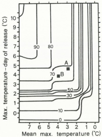
Fig. 5. Avalanche probability as a function of mean maximum temperature during a thaw and maximum temperature on the day of release (Reference WardWard, 1984[b]). A. 30 December 1982; B. 11 April 1984. (Reproduced with permission of Butterworth Scientific Ltd and R.G.W. Ward.)
Discussion
The scale and effect of the two avalanches may appear small in an international context but, in a Scottish context, the observations are important. Compared with avalanches (usually surface slabs or sloughs) recorded by Ward and others (summarized by Reference WardWard (1984[a])), the two avalanches were of average size. The depths of snow involved, however, were above average, despite the relatively low altitude of the site. The slope angle is below average; Reference WardWard (1984[a]) reported that only about 16% of all avalanches recorded in Scotland occurred on slopes of less than 35°. Avalanches, of any type, on south-eastern slopes are uncommon, particularly in areas outside the Cairngorm Mountains (Reference WardWard, 1984(a)). The two avalanches, therefore, appear to be unusual, though the deep drifts, low altitude, and south-east aspect would all seem to encourage the occurrence of avalanches. These points raise the question of just how frequent full-depth slab avalanches are in Scotland.
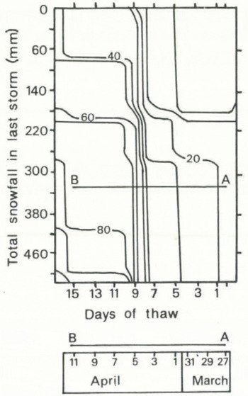
Fig. 6. Plot (A---B) of rise in probability of second avalanche (11 April 1984) as a function of total snowfall in last storm and number of days of thaw (Reference WardWard, 1984[b]). (Reproduced with permission of Butterworth Scientific Ltd and R.G.W. Ward.)
Most avalanches have been recorded in high corries or on high slopes (usually above 900 m; Reference WardWard, 1984[a]) of mountains visited frequently by hill-walkers and skiers. Virtually all of the avalanches recorded at these locations are either sloughs or surface slabs, so it is possible that many full-depth slab avalanches go unrecorded simply because they most probably occur on mountains of relatively low altitude with smooth vegetated slopes, that are not visited frequently by hill-walkers or skiers. There is an opposing argument, however, in that the site studied here appears to have a high “threshold”, i.e. avalanches occur only when the probability is high (≥60%). This may mean that full-depth avalanches, at this site at least, occur only when the probability is high and are therefore rare. The obvious solution is to improve observation techniques.
One way of achieving this would be to identify areas of similar altitude and terrain in Scotland. By identifying similar terrain in a certain area, a “population” of sites where full-depth slab avalanches may be quite frequent can be established. Avalanche observations could then be obtained more easily by concentrating on these sites. Reference Bayfield, Bayfield, Penny and MoyesBayfield and others (1982) have classified the terrain of the Glen Shee area and the Cairngorm Mountains, and this may provide a useful starting point for such an exercise.


