


INTRODUCTION
Textual sources concerning the southern Levant in the 15th–14th centuries BCE give a picture of Canaanite rulers interacting with the Egyptian administration. The clearest window we have on this relationship comes from the Amarna Letters of the 14th century BCE (Moran Reference Moran1992; Rainey Reference Rainey2015), yet also in the second half of the 15th century BCE—widely considered the formative years of an Egyptian administration in the region—comes similar correspondence, particularly within the Ta’anach corpus (Horowitz et al. Reference Horowitz, Oshima and Sanders2006:127–151).Footnote 1, Footnote 2 Further evidence of power centers in the earlier Late Bronze Age (LBA) southern Levant, as seen by the Egyptians, is provided by the administrative text of Papyrus Hermitage 1116A verso (Golénischeff Reference Golénischeff1913). Dated to the reign of Amenhotep II (Redford Reference Redford1965:107–110)Footnote 3, it mentions Maryannu (chariot warrior aristocracy) envoys on their way to Egypt, stopping at various key towns. Appearing on the same document, though not within the list of towns, is the provisioning at Thebes of an envoy from Lachish (Epstein Reference Epstein1963; Helck Reference Helck1971).
From the textual evidence one would reasonably expect to find convincing Late Bronze IB-IIA settlement remains at key southern Levantine tell sites.Footnote 4 Yet there is uneasiness between the archaeological and textual evidence; some towns whose rulers figure prominently in correspondence, exhibit a surprising paucity or lack of settlement evidence. Many scholars have commented on the poor LB IIA remains corresponding to the Amarna era (e.g. Goren et al. Reference Goren, Finkelstein and Na’aman2004:321; Ussishkin Reference Ussishkin and Ussishkin2004a:74–75; Na’aman Reference Na’aman, Finkelstein and Na’aman2011). While the long occupation gaps for LB I have reduced with ongoing excavation and ceramic analysis, some sites that figure in 15th century BCE written sources have puzzling LB IB occupation gaps (e.g. Ussishkin Reference Ussishkin and Ussishkin2004a:58). Resolution of these issues is no simple matter; however, as shown in this article for the case of Tel Lachish, imprecision in the absolute dating of strata is a contributing factor.
TEL LACHISH
Tell ed-DuweirFootnote 5—whose identification as ancient Lachish is well-established—is one of the main type-sites for the LBA in south-central Israel (Figure 1). A large site for this region (7 ha at the summit, 12 ha at the base), it guards a fertile valley connecting the coastal plain in the west with the highlands to the east. Lachish is regarded as one of the three dominant city-states of the Shephelah during the Late Bronze Age (Finkelstein Reference Finkelstein1996; Na’aman Reference Na’aman1997, Reference Na’aman, Finkelstein and Na’aman2011); the town and/or its rulers appear in eight Amarna Letters, of which five are addressed from a ruler of Lachish to the king of Egypt (EA 328–332; Moran Reference Moran1992: Rainey Reference Rainey2015). Footnote 6 Remains dating to the LBA—predominantly LB II-III—have been uncovered in many locations on the mound (Figure 1), as well as nearby caves and tombs.Footnote 7 The remains have been prominent in discussions of the period, and furnished evidence for Egyptian influence and involvement in the region.Footnote 8
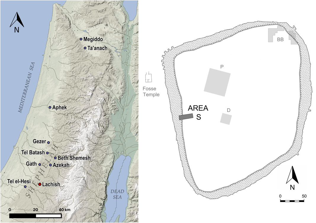
Figure 1 (Left) Tel Lachish among LBA Shephelah sites, and others mentioned in the text; (right) site plan of Tel Lachish showing the main locations where Late Bronze Age remains have been exposed, and highlighting the position of Area S (based on Ussishkin Reference Ussishkin and Ussishkin2004b: Fig. 2.9-10; Weissbein et al. Reference Weissbein, Garfinkel, Hasel and Klingbeil2016; Garfinkel et al. Reference Garfinkel, Hasel, Klingbeil, Kang, Choi, Chang, Hong, Ganor, Kreimerman and Bronk Ramsey2019a).
Tel Lachish has been excavated by six excavation teams.Footnote 9 Of most importance to this article are (1) the British excavations in the 1930s—uncovering the Fosse Temple; (2) the major excavations led by David Ussishkin in the 1970s–1990s—establishing the LBA stratigraphy in the deep trench of Area S; and (3) the current Austrian-Israeli excavations from which radiocarbon data is reported.Footnote 10
The 2013–2017 expedition by Garfinkel, Hasel, and Klingbeil in the northeastern part of the mound added to our knowledge of later LBA levels as well as the destruction that brought Middle Bronze Age (MBA) Lachish to an end (Sass et al. Reference Sass, Garfinkel, Hasel and Klingbeil2015; Weissbein et al. Reference Weissbein, Garfinkel, Hasel and Klingbeil2016; Garfinkel et al. Reference Garfinkel, Hasel, Klingbeil, Kang, Choi, Chang, Hong, Ganor, Kreimerman and Bronk Ramsey2019a, Reference Garfinkel, Kreimerman, Hasel, Klingbeil, Maeir, Shai and McKinny2019b). However, they did not expose occupation remains from the rather elusive LB I-IIA period.Footnote 11
The Austrian-Israeli excavations commenced in 2017, following the cessation of work by Garfinkel, Hasel, and Klingbeil. The new expedition currently focuses on the later Middle Bronze through early Late Bronze Age strata and re-examining their chronology with high-resolution AMS 14C dating. To this end, Ussishkin’s Area S has been reopened, continuing the excavation of earlier LBA levels; as of 2018 work in Area P has also been renewed (Streit et al. Reference Streit, Webster, Becker, Jeske, Misgav and Höflmayer2018).
Lachish Stratigraphy: LB I-IIA
The sole substantial evidence for continuous activity at Tel Lachish through LB IB-IIA is the Fosse Temple, so-called because of its construction within the disused Middle Bronze moat at the base of the mound (Figure 1). Its three phases, spanning LB IB to LB IIB, were fully excavated and dismantled by Starkey’s 1930s excavation (Tufnell et al. Reference Tufnell, Inge and Harding1940). The Fosse Temple is well-known for rich finds attesting to strong international connections, particularly with Egypt. Surprisingly, evidence for settlement on the mound contemporary with Fosse Temple I, and the founding of Fosse Temple II, has been elusive despite considerable exploration.
In Area P on the summit, very little was identified stratigraphically between the domestic remains of Level P-2 (dated to the late LB IIA) and the last use of the Middle Bronze palace structure (Level P-3). Only a few pits and a possible surface were attributed to LB IA, along with several pits in the vicinity of the Fosse Temple (Singer-Avitz Reference Singer-Avitz and Ussishkin2004a:1021; Reference Singer-Avitz and Ussishkin2004b:1026; Ussishkin Reference Ussishkin and Ussishkin2004a:57–58, Reference Ussishkin and Ussishkin2004c). Within the LBA cemeteries of Lachish, just five tombs are safely attributable to the LB I (Singer-Avitz Reference Singer-Avitz and Ussishkin2004a:1021). On the basis of this evidence, a sparse settlement was suggested for LB IA, and a period of abandonment during LB IB.
No architectural remains on the mound are attributed to the Amarna period (Ussishkin Reference Ussishkin and Ussishkin2004a:59–60). The resettlement of Area P (P-2) after LB I was dated to the late LB IIA (Clamer Reference Clamer and Ussishkin2004:1182–1184), along with the lowest levels of Area S (Yannai Reference Yannai and Ussishkin2004:1061–1062). Nevertheless a settlement gap during the Amarna period was not entertained, and it was thought that this level/s had not been reached when excavations ceased in the deep Area S trench. This was the understanding with which we recommenced work in 2017.
The lack of settlement evidence on the mound for LB IB-IIA does not sit well with Papyrus Hermitage 1116A (and letters of late 15th century BCE), nor with the Amarna letters. Further, it has left a question mark over who Fosse Temple I and II served.Footnote 12
Radiocarbon Dating of LB I-IIA Strata at Lachish
An important task upon recommencement of work in Area S has been to re-examine, with high-resolution AMS dating, the absolute chronology of the previously identified LBA levels. Particularly crucial to connecting the old and new excavations, are dates for the lowest levels (S-2 and S-3), from whence a sequence spanning the early LBA to MBA may be expanded as excavation continues. The purpose of this article is to present the revised radiocarbon-based dating of S-2 and S-3, along with a brief discussion of implications for interpreting the occupation history of this very important site.
A set of 14C dates from Area S was published by Carmi and Ussishkin (Reference Carmi, Ussishkin and Ussishkin2004). Whilst this sequence was ground-breaking for its time, it had little impact on the dating of strata due to limitations of that time: (1) Bayesian modeling of radiocarbon data was not yet widely used; (2) samples were primarily from bulk wood charcoal, due to the use of decay counting methods; and (3) precision was lower than can now be attained. Bayesian modeling has drawn out valuable chronological information from this dataset, particularly for later LBA levels (refer to Webster et al. Reference Webster, Sergi, Kleiman, Lipschits, Hua, Jacobsen, Tristant and Gadot2018), however the lower levels of Area S remained particularly weak—an issue that is now addressed by the new, precise AMS data reported here.
It should be noted that while 14C data for later LBA strata (i.e. Levels VII and VI) is available from other parts of the mound—Areas P and GE (Carmi and Ussishkin Reference Carmi, Ussishkin and Ussishkin2004) and more recently the northeastern part of the mound (Garfinkel et al. Reference Garfinkel, Hasel, Klingbeil, Kang, Choi, Chang, Hong, Ganor, Kreimerman and Bronk Ramsey2019a)—radiocarbon data for earlier LBA strata is thus far restricted to Area S.
Late Bronze Age Stratigraphy of Area S
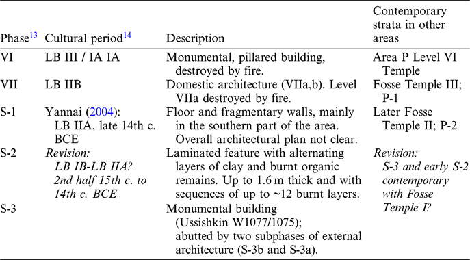
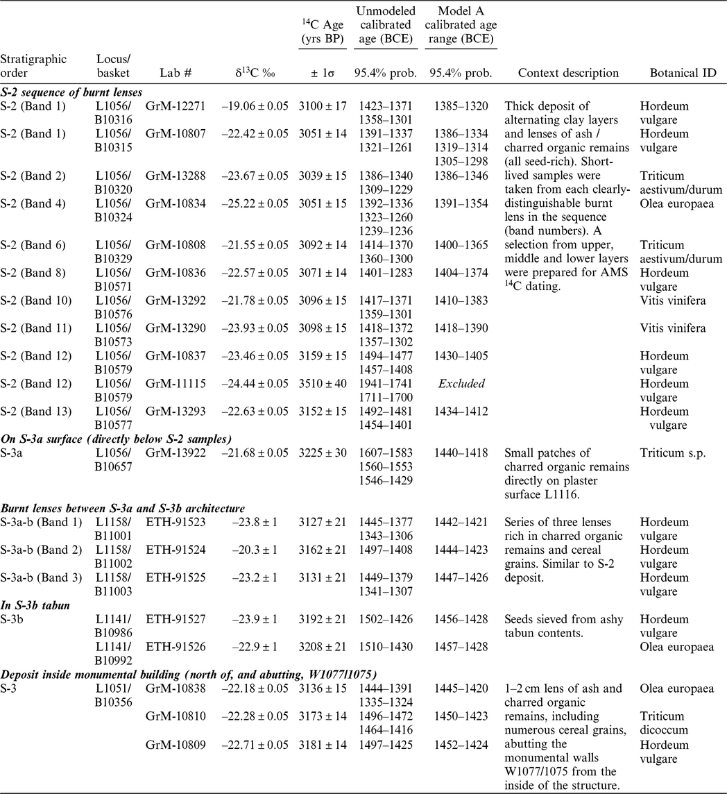
Five main LBA phases were uncovered in Area S (Table 1; Barkay and Ussishkin Reference Barkay, Ussishkin and Ussishkin2004). The upper levels, VI and VII, represent prosperous cities that both ended in destruction, providing important 13th and 12th centuries BCE ceramic assemblages. Below the two subphases of Level VII (a,b), were the meagre remains of Level S-1 domestic architecture, consisting of just a few wall segments and patches of flooring. These remains were laid directly upon the laminated deposit of Level S-2. Found extending across most of Area S, Level S-2 consisted of a thick build-up of alternating clay and dark brown layers, the latter being rich in ash and carbonized organic remains. The overall thickness varied across the area (0.5–1.6 m), as did the number of layers (from just a few to a dozen). The layers were horizontal in many excavation squares, but in places they rise and fall, having been deposited over the decayed mudbrick courses of earlier walls (e.g. Ussishkin W1077/1075) and compressed by later architecture. No architecture was found in association with S-2. Laminated features similar to Level S-2 have been noted at other sites, with some particularly striking examples (by depth and extent) encountered at Tel Gezer (Dever Reference Dever1986:61–63; 73–76), Tel Aphek (Gadot Reference Gadot, Gadot and Yadin2009:96–98) and Tel Hesi (Petrie Reference Petrie1981, Pl.III; Bliss Reference Bliss1894:64–65). On the nature of these deposits there is lack of agreement; explanations have included threshing floors, waste disposal areas, animal pens, industrial deposits or destruction layers. For a recent geoarchaeological assessment of a smaller deposit at Megiddo, see Shahack-Gross et al. (Reference Shahack-Gross, Gafri and Finkelstein2013).
Table 1 Late Bronze Age stratigraphy of Lachish Area S (based on Ussishkin 2004a, Table 3.3; Barkay and Ussishkin 2004).
Immediately underneath the S-2 deposit was found the substantial architecture of Level S-3. This includes monumental walls—Ussishkin’s W1077 and W1075—forming part of a building that lies mostly beyond the northern extent of the area (Figure 2). Walls of several smaller external units abutting this structure on the south were exposed by Ussishkin across Area S. In 2017–2018 the renewed Austrian-Israeli excavation uncovered an earlier subphase of external architecture (S-3b) abutting W1077/W1075.
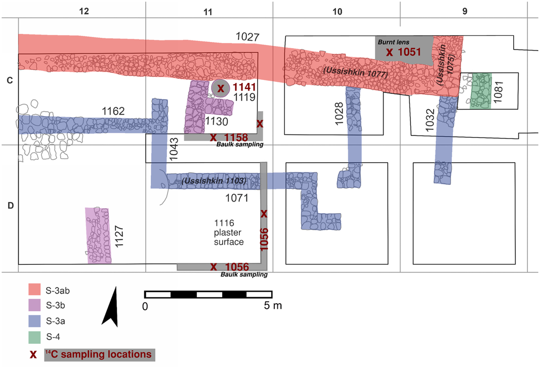
Figure 2 Plan of Level S-3 architecture, and the 14C sampling locations of both S-3 and S-2.
While Level S-3, with its monumental architecture, undoubtedly represents a well-organised settlement, the picture is less clear-cut for Level S-2. Since no associated architecture was found, one may question whether there was an associated settlement on the mound, or if the deposit merely reflects utilization of space during a period of abandonment. Two aspects point towards the former: Firstly, the S-2 deposit contains large quantities of pottery sherds, including many imports, along with animal bones and flint tools; as Barkay and Ussishkin (Reference Barkay, Ussishkin and Ussishkin2004:342) argued, this best fits an open area adjacent to a settlement. Secondly, the new excavations have revealed similar charred layers sandwiched between or associated with S-3 architecture, suggesting that S-2 does not represent a completely new pattern of activity.
Yannai (Reference Yannai and Ussishkin2004:1061–1062) considered the S-3–S-1 pottery assemblages to be chronologically indistinguishable, and noted similarity to the Fosse Temple II pottery. Fosse Temple II could not have commenced prior to the reign of Amenhotep III,Footnote 15 since a plaque bearing this king’s name was found below its foundations (Tufnell et al. Reference Tufnell, Inge and Harding1940:69, 90, Pl. XXXIIA:5). A seal of Amenhotep III was also found in an S-2 context (Keel Reference Keel and Ussishkin2004, List no. 25). Yannai favoured a dating of both Fosse Temple II and S-3–S-1 after Amenhotep III, in the late 14th century BCE. Ussishkin (Reference Ussishkin and Ussishkin2004a:57–59) accepted Tufnell’s date for the Fosse Temple II enlargement during the reign of Amenhotep III (Tufnell et al. Reference Tufnell, Inge and Harding1940:20), but took S-3–S-1 as contemporaneous only with the later part of Fosse Temple II.
14C SAMPLING APPROACH
The samples reported here were collected during the 2017–2018 seasons of the Austrian-Israeli excavation. All are short-lived—a variety of seed types collected from burnt contexts, rich in organic remains (Figures 2–4).
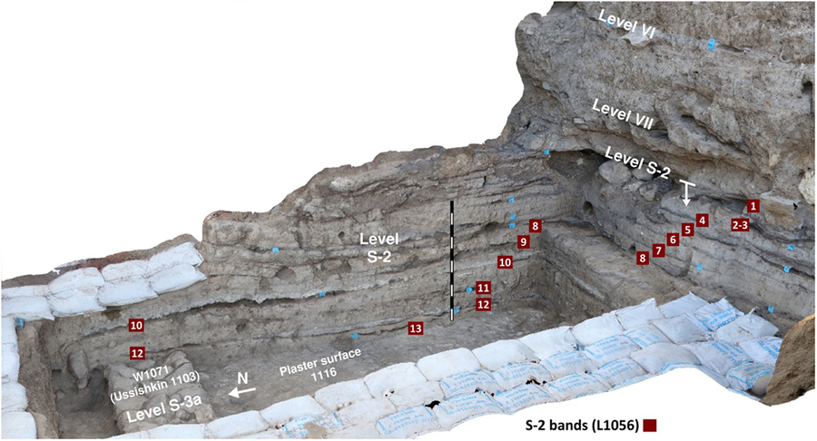
Figure 4 Level S-2 sequence of burnt lenses L1056, with sampling locations marked.
Upon reopening Area S, the previously excavated LBA levels were readily recognized: remains of S-3; the laminations of S-2, preserved in many baulks; and Levels VII and VI in the major northern and southern sections. Samples for Level S-3 were obtained both inside and outside the monumental building. Inside the building (close to the northern edge of the area) a seed-rich burnt lens (L1051; Figure 3) was found, clearly abutting the monumental walls (Ussishkin’s W1077/1075). This discovery is particularly important since no floor/surface was previously identified inside the monumental building. The S-3 external architecture is represented by samples from S3-b tabun L1141 and overlying burnt lenses L1158 (Figure 3). The uppermost S-3 sample consists of charred remains lying directly upon plaster surface L1116 (Figure 4). Barkay and Ussishkin (Reference Barkay, Ussishkin and Ussishkin2004) considered L1116 the floor of Unit 8018 (our S-3a subphase), though the present expedition recognizes that L1116 in fact ran underneath wall 1071 (Ussishkin’s W1103) rather than abutting it.

Figure 3 Level S-3 14C contexts: (top left) S-3b tabun L1141; (top right) detail of burnt lens L1051 within the monumental building, abutting Ussishkin’s W1077/1075 (part of the deposit has been removed to show the underlying surface); (bottom) burnt lenses L1158 between S-3b and S-3a architecture (south baulk of square C11).
The thick S-2 deposit overlies L1116 and W1071 in square D11 (Figure 4). This sampling location was chosen since here the full depth of S-2 could be sampled (including ~12 preserved layers) and subsequent occupation Levels VII and VI can be readily identified in the adjacent southern section. Further, square D11 is a focus of continued excavation to expose (and radiocarbon date) deeper strata. Rather than excavating down through standing baulks, collection of S–2 material was done directly from the eastern and southern sections of the square; this facilitated more precise and efficient sampling from the series of burnt lenses. Samples were collected from each clearly separated lens (see “band” numbers in Figure 4), though fewer were radiocarbon dated (Table 2).
Table 2 New radiocarbon dates obtained for the lowest levels of Area S, Tel Lachish.

14C LABORATORY METHODS
Radiocarbon dating was carried out at the University of Groningen and ETH Zurich AMS laboratories. Only single entities (i.e. one seed or fragment) were prepared for each measurement, to avoid any possibility of averaging between seeds of differing age. An acid-alkaline-acid (AAA) pretreatment protocol was generally applied to remove carbon-bearing contaminants (Mook and Streurman Reference Mook, Streurman, Mook and Waterbolk1983); in some cases the alkaline wash was omitted to avoid dissolution of the samples (ETH-91523 to 91527). As shown by Wild et al. (Reference Wild, Steier, Fischer and Höflmayer2013), dating humic acids from such contexts yields reliable results. The pretreated samples were combusted in an elemental analyzer (EA), and the resultant CO2 converted to graphite using the H2/Fe method. An isotope ratio mass spectrometer (IRMS) coupled to the EA measured δ13C for isotopic fractionation correction. Accelerator mass spectrometry (AMS) radiocarbon analysis of the samples, along with standards and blanks, was made using a MICADAS (IonPlus®) accelerator.
Radiocarbon ages are reported in 14C years before present (BP) following international convention (Stuiver and Polach Reference Stuiver and Polach1977; Millard Reference Millard2014). Calibrated ages in calendar years were obtained using OxCal v 4.3.2 (Bronk Ramsey Reference Bronk Ramsey2009a) and the IntCal13 calibration curve (Reimer et al. Reference Reimer, Bard, Bayliss, Beck, Blackwell, Bronk Ramsey, Buck, Cheng, Edwards, Friedrich, Grootes and Guilderson2013) interpolated to yearly intervals (Resolution = 1).
RESULTS
The new 14C data for the lower levels of Area S form a coherent, well-ordered dataset in the range 15th to 13th centuries BCE (Table 2, Figure 5).Footnote 16 Unfortunately, much of the S-2 data has considerable spread (both 1 and 2σ >100 years) due to a large wiggle in the calibration curve (see supplementary online materials Figure X1). To obtain more precise chronological information, the 14C data should be combined with prior knowledge of stratigraphic order, usually done using a Bayesian approach (Buck et al. Reference Buck, Kenworthy, Litton and Smith1991, Reference Buck, Litton and Smith1992; Bronk Ramsey Reference Bronk Ramsey2009a). Such an analysis was first applied to the new data in isolation (Figure 6, Model A), before incorporating existing 14C data from Area S (Carmi and Ussishkin Reference Carmi, Ussishkin and Ussishkin2004) (Figure 6, Model B). The OxCal code for both models is provided in the supplemental online materials.
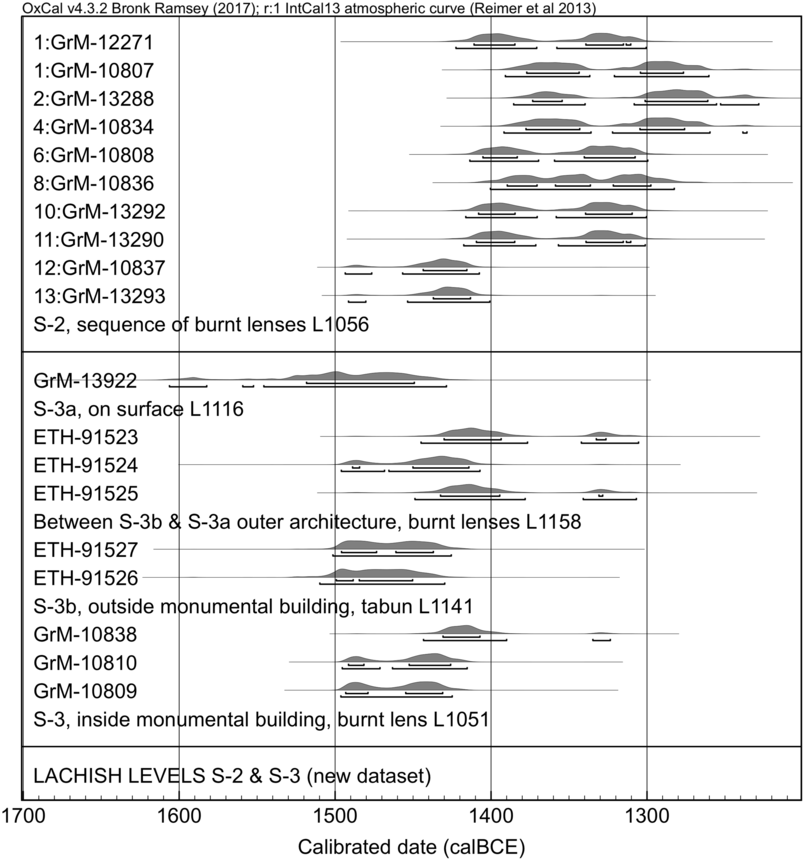
Figure 5 Independently calibrated new 14C dates from Levels S-2 and S–3. (GrM-11115 not shown.)
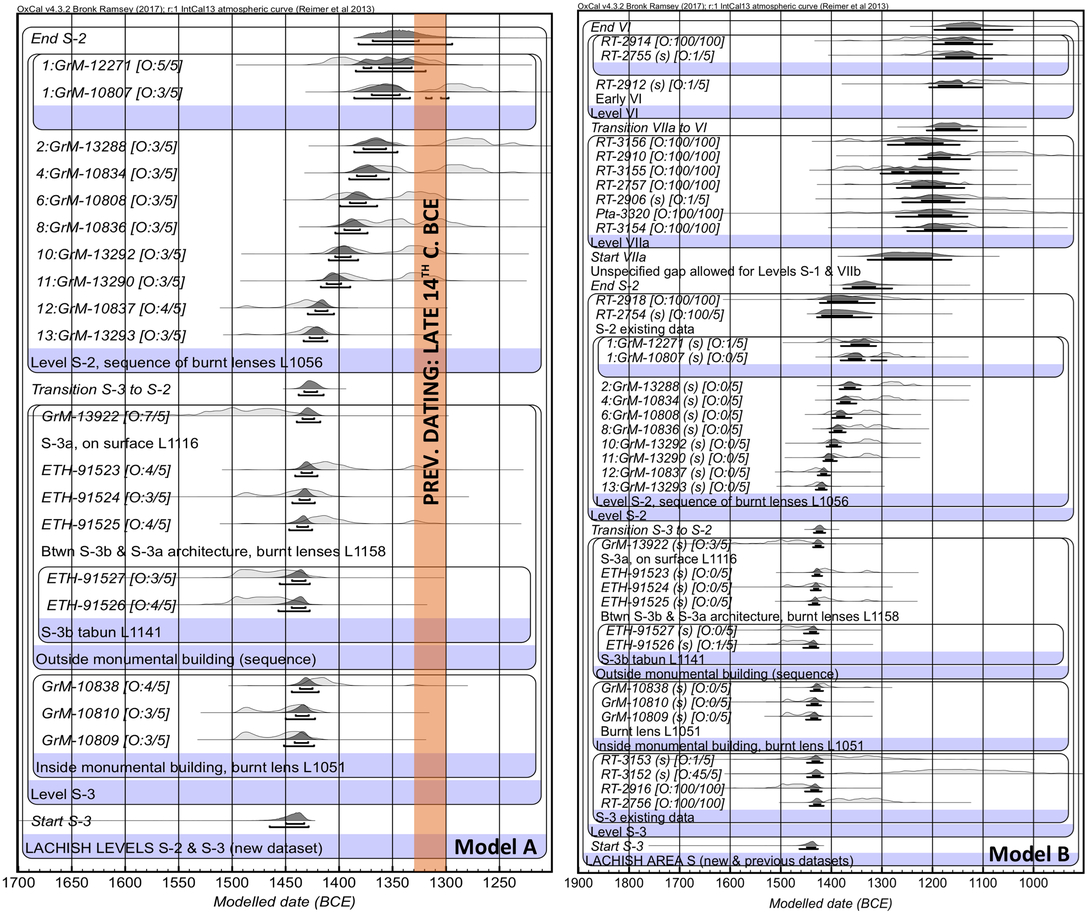
Figure 6 Bayesian analysis. Model A utilizes only new data for Levels S-2 and S-3. Model B incorporates existing data from all Late Bronze phases of Area S. In Model B, short-lived samples are denoted with “(s)”.
Beginning with Model A, the new S-3 data is arranged in two parallel phases, since the relative ordering of samples inside and outside the monumental building is difficult to know with certainty. From a single context inside the building are three new dates (L1051; GrM-10809, 10810, and 10838). The sequence of dates from external architectural subphases consists of (from oldest to youngest): two dates from S-3b tabun L1141 (ETH-91526 and 91527), one date from each of three charred lenses that overlie the S-3b architecture (L1158; ETH-91525, 91524 and 91523), and one date from charred material lying directly on surface L1116 (lowest lens of L1056; GrM-13922).Footnote 17
Eleven dates from burnt lenses within the laminated deposit of S-2 are arranged in stratigraphic sequence, above the S-3 phase. Regarding this dense sequence, we assume that the S-2 layers were not deposited rapidly but over a longer period, with different growing seasons represented in the organic material; this is supported by several observations: (1) depth of the deposit; (2) presence of similar charred layers between subphases of S-3 architecture; (3) evidence of ordering in the radiocarbon data before modeling.
A contiguous boundary is assumed between the S-3 phase and S-2 sequence, as the archaeological evidence strongly indicates continuity. Outlier analysis is applied, such that the model can identify outliers and weight their influence accordingly, avoiding the need to manually remove them (Bronk Ramsey Reference Bronk Ramsey2009b). An alternate approach to handling outliers, using agreement indices, gives similar results (see supplemental online materials Figure X2).Footnote 18 In Model A all of the dates derive from short-lived materials; thus a “General” outlier distribution is assumed (Student’s t distribution) with prior outlier probabilities of 5%.
Model A places Level S-3 and the transition to Level S-2 firmly within the second half of the 15th century BCE. Level S-2 continues through the first half of the 14th century BCE. It may be noted that before modeling many of the S-2 dates include probability extending into the late 14th and 13th centuries BCE; this is due to wiggles in the 14C calibration curve (refer Figure X1). However, when relative stratigraphic order is taken into account, it becomes clear that the S-2 deposit was laid down predominantly during the first half of the 14th century BCE. The last layers of S-2 were most likely deposited within the middle third of the century, but the late 14th century BCE remains a possibility.
Having considered the new data alone, we include an updated model for the LBA in Lachish Area S. Model B incorporates the existing data of Carmi and Ussishkin (Reference Carmi, Ussishkin and Ussishkin2004). We prefer a single area model that does not include data from other excavation areas; thus the model is constrained only by prior information from stratigraphic order, and not ceramic parallels between areas.Footnote 19 Carmi and Ussishkin’s dataset includes four dates from S-3 and two from S-2, which we arrange in phases parallel to the new data. Seven and three dates, respectively, represent later Levels VII and VI. A contiguous boundary is assumed between Levels VII and VI, but a non-contiguous boundary between S-2 and VII allows for the absence of data from S-1 and VIIb.
We have chosen to include both wood and short-lived dates of the Carmi and Ussishkin dataset. There are very few dates of the latter categoryFootnote 20 and restricting the model to only short-lived samples would mean eliminating most of the previous dataset from consideration. As shown by Dee and Bronk Ramsey (Reference Dee and Bronk Ramsey2014) the wood data contains valuable information beyond merely a terminus post quem. Potential inbuilt age within the wood data is addressed by applying a “Charcoal Plus” outlier model; this assumes an outlier distribution exponentially approaching the true context age, while also allowing a small possibility that some wood charcoal may be intrusive. The wood dates are each given a 100% prior probability of being an outlier (i.e. having a biological age earlier than the context).Footnote 21
Comparing Models A and B, it may be noted that the larger model does little to alter the results of Model A. The less precise previous data for Levels S-2 and S-3 have minimal influence and are broadly compatible (with the exception of clear outliers RT-2754 and RT-3152). The inclusion of data from Levels VIIa and VI has a minor downward effect on the end of S-2; in reverse, the new S-2 to S-3 dataset has a more perceptible effect on the Level VII data, yielding more probability in the 13th century BCE than seen in previous models (Webster et al. Reference Webster, Sergi, Kleiman, Lipschits, Hua, Jacobsen, Tristant and Gadot2018).
Manning et al. (Reference Manning, Griggs, Lorentzen, Bronk Ramsey, Chivall, Jull and Lange2018) recently published evidence for a small regional 14C offset for the southern Levant, measured at 19 ± 5 years in tree records of the 17th–19th centuries CE. A similar offset was found in Egypt by Dee et al. (Reference Dee, Brock, Harris, Bronk Ramsey, Shortland, Higham and Rowland2010, Reference Dee, Shortland and Bronk Ramsey2013a).Footnote 22 We have considered the potential effect of an offset of this magnitude on the Lachish LBA data (refer to Figure X3) and note that it has limited impact. The conclusions for the dating of S-3 and S-2 remain the same; probability for a later continuation of S-2 is increased in Model B but >80% probability remains within the 14th century BCE.
DISCUSSION
The new 14C data and Bayesian analysis place Lachish Level S-3 within the second half of the 15th century BCE, and the commencement of Level S-2 before the close of that century. It is therefore evident that the previous excavation in Area S reached a century further back into the LBA than was previously thought.
The redating of Level S-3 eliminates the occupation gap previously suggested at Lachish for the 2nd half of the 15th century BCE. With its monumental architecture, S-3 now constitutes evidence for a substantial, well-organized settlement at this time. In terms of Egyptian chronology, this corresponds to the reigns of Thutmoses III and Amenhotep II, leading to improved agreement with textual sources—notably the reference to Lachish in Papyrus Hermitage 1116A during the reign of Amenhotep II.Footnote 23 Given the generally accepted dating of Fosse Temple I to this same period, S-3 may constitute the missing contemporaneous settlement.
The laminated deposit of Level S-2—evidence of intensive activity, and in our view of settlement on the mound—commenced in the late 15th century BCE and continued through the first half of the 14th century BCE. The lowest layers of the deposit probably predate Fosse Temple II (built during or after Amenhotep III). A starting date for S-2 prior to Amenhotep III is not contradicted by the seal of this king found in S-2 L3938 (Keel Reference Keel and Ussishkin2004, List no. 25), as it was retrieved from the upper layers of the deposit (Barkay and Ussishkin Reference Barkay, Ussishkin and Ussishkin2004:326, Figure 8.11). In fact when this evidence is combined with 14C, we see that S-2 must overlap Amenhotep III’s reign (and probably also Fosse Temple II). Level S-2 seems to have ended in the middle third of the 14th century. It is difficult to more precisely establish this endpoint, or the beginning of the Level VII city, unless high quality dates from the directly overlying strata (S-1 and VIIb) can be obtained.
The impact of the new S-3–S-2 14C results on synchronization with Egyptian history is further discussed by Webster et al. (Reference Webster, Streit, Dee, Hajdas and Höflmayer2019), using direct comparison with 14C analysis for the absolute dating of the New Kingdom (Dee Reference Dee, Shortland and Bronk Ramsey2013b).
The current results should be viewed as a redating of specific strata rather than evidence for a wider adjustment to the absolute dating of cultural periods. The ceramic assemblages of S-3–S-1 were modest, consisting predominantly of sherd material with few restorable vessels (unlike the much larger whole vessel assemblages of Levels VII and VI). Furthermore, the inherent difficulties in differentiating LB IB and IIA pottery may be noted. Thus while Yannai placed S-1–3 in LB IIA, a reattribution of S–3 to LB IB should be considered.Footnote 24 The presented results furthermore serve as an example of how 14C dating can help to reassess LB I occupation gaps, which have been exaggerated in some cases through an overreliance on imported fossil directeur pottery types (e.g. Bourke Reference Bourke1993:166–167; Duff Reference Duff2015:62–70).
Few 14C datasets have been published from LB IB-IIA strata of southern Levantine sites. This portion of the important Megiddo sequence is under-represented; however it may be said that Stratum F-10 is likely contemporary with Lachish Level S–3, and Stratum K-9 with Level S-2 (Toffolo et al. Reference Toffolo, Arie, Martin, Boaretto and Finkelstein2014).Footnote 25 Closer to Lachish, recent excavation and 14C work at Tel Azekah is also augmenting our picture of the Shephelah during the Amarna period, indicating the presence of a thriving town with public architecture (Webster et al. Reference Webster, Sergi, Kleiman, Lipschits, Hua, Jacobsen, Tristant and Gadot2018; forthcoming).
CONCLUSION
Our 14C-based reassessment in Lachish Area S, using a new suite of well-stratified samples from secure contexts, shows that the date of Level S-3 and the commencement of Level S-2 should be raised by a century. Consequently these levels now furnish evidence of a prominent, well-organized settlement at Lachish during the 2nd half of the 15th century BCE, as well as an indication of continued settlement through the Amarna period in the 14th century BCE. Noting the improved agreement with textual evidence for Lachish’s prominence and interaction with the Egyptian administration during LB IB-IIA, this outcome highlights the important role of 14C for correctly synchronizing southern Levantine strata with Egyptian history.
ACKNOWLEDGMENTS
This research was funded by Austrian Science Fund (FWF) START grant Y-932, “Tracing transformations in the southern Levant: from collapse to consolidation in the mid-second millennium BC,” directed by Dr Felix Höflmayer. The work forms part of the leading author’s PhD research. The authors would like to thank the excavation staff of the Austrian-Israeli Expedition to Tel Lachish, and the laboratory teams at the University of Groningen and ETH Zurich AMS facilities. We are grateful to Dr Mans Schepers for botanical identifications made at the University of Groningen’s archaeobotany laboratory; further identifications were made by Marco Nicoli (Tübingen University). Insightful comments offered by Stephen Bourke and Yuval Gadot on the manuscript are gratefully acknowledged.
Supplementary material
To view supplementary material for this article, please visit https://doi.org/10.1017/RDC.2019.131


 Open access