

Introduction
Japan is an earthquake-prone island nation with large portions of the population living in coastal areas. On March 11, 2011, more than 15000 people were killed by a massive tsunami caused by the Great East Japan Earthquake. A future Nankai Trough earthquake is expected to destroy up to 2.3 million homes, claim the lives of 265000 people, and necessitate the rescue of 29000 people because of the ensuing tsunami. 1 For this reason, tsunami evacuation planning is 1 of the most important disaster countermeasures in the event of a major earthquake in Japan.
The ability of residents to evacuate from tsunamis varies according to age, physical condition, and living conditions. However, these differences are not fully reflected in current evacuation policies. Little consideration has been given to the evacuation of pregnant women. The main method of evacuating from a tsunami is to walk or run to higher ground or to a tsunami evacuation building. Large cities in coastal areas of Japan have areas of reclaimed land, which are close to and sometimes below sea level. In these areas, evacuation to a tsunami evacuation building is the first choice because higher ground is often too far away. Women in the last trimester of pregnancy are less mobile and may have difficulty walking long distances, but these factors are not reflected in official evacuation plans. In Aichi Prefecture, which is at high risk of being hit by a major tsunami in the event of a major Tonankai or Nankai Trough earthquake, the government has taken the initiative to increase the number of tsunami evacuation buildings, but no measures have been taken to accommodate the needs of pregnant women. 2 The Japanese Midwives Association of Aichi has therefore, begun to study a plan for midwives to help pregnant women evacuate in the event of a disaster. 3 To make such studies more effective, it is necessary to evaluate evacuation measures that consider the characteristics of pregnant women.
In contrast to the conventional wide-area evacuation plan, the individual evacuation plan (IEP) has been proposed as an evacuation plan that considers the needs of each resident. The IEP is developed based on characteristics such as age, physical condition (e.g., disabilities and illnesses), and family situation, as well as local resources such as nearby evacuation sites, evacuation routes, and community support for evacuation. In the town of Kuroshio in Kochi Prefecture, where a 34.4-m tsunami is predicted to hit in the event of a major Nankai Trough earthquake, about 250 groups consisting of 10 to 15 neighboring households have been organized, and evacuation plans have been formulated for each household. Reference Shinbun4 At present, their IEPs represent the most advanced model for evacuation planning in Japan.
To create an IEP, it is important for residents to know exactly how their evacuation behavior will be affected by their personal physical conditions. Therefore, in this study, we developed a simulation model to evaluate the possibility of pregnant women evacuating to tsunami evacuation buildings. A unique feature of this model is its use of data published by the Japanese government and a general-purpose geographic information system (GIS) system. Therefore, the model does not require any special data or systems to be specifically developed for this purpose. In this paper, we present the method used to construct the model and conduct simulations using data from Nagoya City, Aichi Prefecture and discuss the results.
Methods
Source data
In the proposed method, a simulation model for evaluating the possibility of pregnant women evacuating to tsunami evacuation buildings is constructed using the following data: number of pregnant women in each elementary school district, tsunami inundation forecast map, location information of tsunami evacuation buildings, and number of general housing units.
The number of women who become pregnant in each municipality is provided once a year by the Ministry of Health, Labor and Welfare. However, when considering tsunami evacuation policy, more detailed data at the ward level is required because it is difficult for pregnant women to evacuate by walking long distances. In this paper, we used elementary school districts because in many areas, these districts are limited in size according to the distance that elementary school students can walk from their home to school and back. A method using machine learning to estimate the number of pregnant women in each elementary school district has been proposed by Hattori, et al. Reference Hattori and Hattori5 In the present study, we use the values obtained from that method as estimates of the numbers of pregnant women in each elementary school district. For the tsunami arrival forecast map, we used the tsunami inundation forecast map published by each local government.
Tsunami evacuation buildings are public or private facilities designated by the government as an emergency or temporary evacuation facility in areas where evacuation from a tsunami is expected to be particularly difficult. These buildings include schools, government offices, public housing, private apartments, and commercial buildings. The location information of tsunami evacuation buildings was obtained from data published by each municipality. This study uses the number of ordinary buildings in each elementary school district to estimate the number of non-escapable pregnant women. The number of ordinary buildings is based on data from the Housing Land Use Survey published by the Geospatial Information Authority of Japan. 6
Calculating the area in which people can reach a tsunami evacuation building on foot
According to a report by the Fire and Disaster Management Agency of the Ministry of Internal Affairs and Communications, the average walking speed during a tsunami evacuation is expected to be 1.0m/s and the maximum distance that can be traversed to reach an evacuation building is 500m. 7 However, the walking speed of people who have difficulty walking, people with physical disabilities, parents with young children, and people with serious illnesses is estimated to be as low as 0.5m/s. Pregnant women have a less stable gait and tend to decrease their stride length, increase their walking interval, and decrease their walking speed to compensate. Reference Lymbery and Gilleard8,Reference Sawa, Doi, Asai, Watanabe, Taniguchi and Ono9 For this reason, we assume that pregnant women also walk at around 0.5m/s, and that the maximum distance they can evacuate is 250m. Given that residents evacuate by walking on the road, it is not realistic to estimate the evacuation area by using a circle with a straight-line distance of 250m to the tsunami evacuation building. Therefore, we used road centerline data and network analysis to calculate the area within a 250-m walk from the center point of the tsunami evacuation building.
Identification of evacuation potential areas
We calculated the reachable area for each of the tsunami evacuation buildings in the region. The area inside the convex hull is the area where pregnant women can reach the tsunami evacuation building.
Estimation of the number of pregnant women residing in escapable areas
To determine how many pregnant women would and would not be able to evacuate in each elementary school district, we made an estimation based on the ratio of the number of households in the escapable area to that in the non-escapable area. Using data from the Geospatial Information Authority of Japan, we calculated the number of general housing units in each of the 2 areas. Assuming 1 household per general housing unit, the numbers of pregnant women in the escapable and non-escapable areas were estimated by dividing the estimated number of pregnant women in an elementary school district by the ratio of the number of general housing units.
Simulation in Nagoya City
The city of Nagoya was predicted to be hit by a tsunami approximately 100 minutes after a major Nankai Trough earthquake. 10 Hattori, et al. showed that if Nagoya City were to be hit by a tsunami, more than 1200 pregnant women would not be able to evacuate and would likely be left behind in the tsunami inundation area. Reference Hattori, Miyagawa and Hattori11 Here, we present a method for constructing a simulation of evacuating to a tsunami evacuation building based on data from the city of Nagoya. This includes the following 3 steps:
First, we estimated the number of pregnant women in elementary school districts using the machine learning model constructed by Hattori et al. Out of the 16 wards in Nagoya, 7 are in tsunami inundation areas. There are 110 elementary school districts in these 7 wards. As the source data for estimation, we used data from the 2017 Report of Regional Healthcare and Health Promotion Activities, 12 and 5-year population data of subdistricts in Nagoya in 2017 from the basic resident registry data on e-Stat (Statistics Bureau, Japan), a statistical database provided by the Japanese government. 13
Second, to identify areas from which people can evacuate to tsunami evacuation buildings, we performed a network analysis using the road centerline data of Nagoya and determined the area within a 250-m walk from each tsunami evacuation building as a convex hull. We also performed network analysis on 1000 government-designated tsunami evacuation buildings in Nagoya to identify the area covered by the convex hull within a walkable 250m distance, i.e., the area where pregnant women can reach the tsunami evacuation building before the tsunami strikes.
Finally, we estimated the number of pregnant women living in a non-escapable area in each elementary school district. This was obtained by determining the ratio of the number of ordinary buildings not included in the convex hull to the total number of ordinary buildings and multiplying this ratio by the number of pregnant women in each elementary school district. In this paper, we assumed that this ratio approximates the distribution of pregnant women, given that a regular building usually houses only 1 household.
Results
In the first step, we estimated the number of pregnant women in 110 elementary school districts at risk of tsunami inundation using the machine learning model constructed by Hattori, et al. QGIS 3.1.2 (QGIS Project, Institute for Mapping Technology, Austin, Texas, USA) was used for this analysis. 14 Figure 2 shows the estimation results. The data is presented in numerical and choropleth maps.
In the second step, we performed a network analysis of the road centerline data to determine areas within a specific distance on the road from a particular location as a convex hull. Figure 1 shows the area within 250-m road distance from a tsunami evacuation building. The red line represents the boundary of the 250-m road distance from the center of the tsunami evacuation building. Evacuees can reach the tsunami evacuation building within 250m from the starting point facing the road indicated in blue.

Figure 1. Convex hull representing the area within a 250m walk from the tsunami evacuation area.
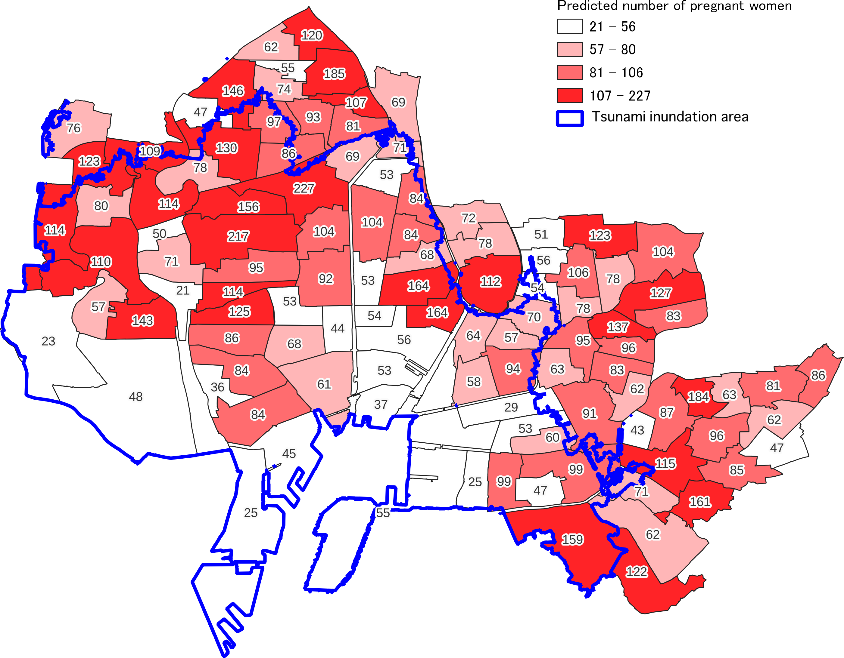
Figure 2. Predicted number of pregnant women residing in 110 at-risk elementary school districts in Nagoya.
Furthermore, we conducted a network analysis of 1000 government-designated tsunami evacuation buildings in Nagoya City, and the results are shown in Figure 3. The yellow dots in the figure represent tsunami evacuation buildings. 15 The white areas around the tsunami evacuation buildings are areas where pregnant women can reach the tsunami evacuation buildings on foot before the tsunami strikes. The blue line marks the boundary of the area where the tsunami will reach. Therefore, the area surrounded by the blue line and painted in purple represents areas where pregnant women cannot reach the tsunami evacuation building on foot before the tsunami strikes.

Figure 3. Escapable and non-escapable areas in coastal wards of Nagoya during a tsunami.
In the final step, we estimated the number of pregnant women residing in non-escapable areas. Table 1 shows the number and ratio of regular buildings included in the convex hull around the tsunami evacuation building (the escapable area) and those not included in the convex hull (the non-escapable area), in each elementary school district. In this table, elementary school districts with a value of zero for ordinary buildings in the non-escapable area are areas that are not expected to be inundated by the tsunami. The number of pregnant women who could evacuate was estimated by calculating the ratio of the number of houses within a 250-m walk from a tsunami evacuation building to the number of houses outside that range. We defined high-risk areas as those where the ratio of pregnant women unable to evacuate to the total number of pregnant women in the area is higher than the third quartile. The results are displayed on a map in Figure 4.
Table 1. Predicted number of pregnant women residing in non-escapable areas and the risk level of elementary school districts


Figure 4. Predicted total number of pregnant women in each elementary school district and predicted number of pregnant women expected to have difficulty evacuating (number in parenthesis).
Comparing Figure 3 with Figure 4, the risk of pregnant women not being able to evacuate is shown in Figure 4 and follows outside of the coverage for the school district in the convex hull centered on the tsunami evacuation building shown in Figure 3.
The center of the map is an area that is both high-risk and has a large, estimated number of pregnant women. This area is dominated by low-rise residential buildings and has few tsunami evacuation buildings (C4, C6, C13, C15, C16, C18, C23, and C22 in Table 1). On the other hand, there are also areas with many pregnant women but with FAIR or LOW risk (C7, C9, C10, C11, and C21 in Table 1). These areas, shown in Figure 3, have many tsunami evacuation buildings in the school district and they are homogeneously distributed, so that the 250-m convexity covers most of the school district.
On the left side of the map is the area with a small number of pregnant women but with a high risk of not being able to evacuate (A4, A18 in Table 1). This area is old, reclaimed land, still has some farmland, and there are not many houses in the area. There are few tall buildings in this area due to the soft ground, making evacuation difficult for pregnant women. The current risk of these areas might be overestimated as mentioned in the next section, however, when the conversion from farmland to residential land progresses in the future in this area, it will still be difficult to construct tall buildings due to the soft ground. Therefore, if development progresses and younger generations come to live in the area, there is a possibility that more pregnant women will have difficulty evacuating.
Limitations
There are a couple of limitations that led to a higher evaluation of risk than the actual risk, for some areas. An example is where only a portion of an elementary school district is included in the assumed tsunami inundation area. The model in this study assumes that the entire school district is inundated, even if only a portion of the school district is inundated. If the assumed inundation area is only a small portion of the school district, the number of tsunami evacuation buildings and regional coverage of the entire school district is low and therefore considered to be at high risk. Therefore, school districts that are on the boundary of the expected tsunami inundation zone such as C-12, D-9, D-15, G-14 should be individually assessed for risk according to the actual situation.
Another example is seen where there are many elevated areas in the district. In this study, elevation was not considered because most of the central Nagoya area is low elevation land. Even in areas that are expected to be inundated by tsunamis, the actual risk of delayed escape is low in areas with many elevated lands in the district, even if the number of tsunami evacuation buildings is small. Furthermore, if there are many areas in the school district that are not inhabited by pregnant women, such as farmland (A-4, A-18) or factories (E-13), the risk may be assessed higher than it is because the coverage of tsunami evacuation buildings will be smaller.
Discussion
This method enabled us to evaluate whether pregnant women would be able to evacuate to tsunami evacuation buildings in each district. In addition, this estimation is based on public data and a general-purpose information system. Therefore, the same evaluation can be performed for other areas in Japan. However, using the current method, the accuracy of the estimation can be degraded by several geographic conditions, namely, uneven land use conditions within a district and large differences in elevation within a district. The simulation methods and techniques for estimating the distribution of pregnant women should be improved for such cases.
Studies on simulated tsunami evacuations using GIS include Kubish, et al.’s study on simulated tsunami evacuations in Chile, Reference Kubisch, Guth, Keller, Bull, Keller and Braun16 and Takabatake’s study in Tofino, Canada. Reference Takabatake, Nistor and St-Germain17 Among the studies on simulated tsunami evacuations, some specifically focus on people who need assistance during disasters. Sugiki, et al. proposed an evacuation simulation model that considers the differences between elderly and non-elderly people. Reference Sugiki, Hirata and Matsuo18 Nakai, et al. simulated the evacuation of patients receiving home health care with the assistance of home nurses. Reference Nakai, Itatani, Horiike, Kyota and Tsukasaki19 However, to date, no studies have performed simulations to determine the possibility of pregnant women evacuating to a tsunami evacuation building. In addition, to our knowledge, no studies have used elementary school districts as the unit of analysis. Given that pregnant women walk slower, they are less likely to be able to reach the evacuation building at the same time as the general population. The assessment of access to tsunami evacuation buildings is an important indicator of how many pregnant women are capable of vertical evacuation. Residential communities such as neighborhood associations in Japan overlap with elementary school districts. Since pregnant women may need to evacuate with the support of their neighbors, an analysis at the elementary school district level is essential for the formulation of IEPs. Moreover, the duration of a woman’s pregnancy is about 9 months, which is a short period of time compared with that spent as an elderly person or chronic home care patient. Therefore, it may be difficult for pregnant women or their families to recognize the need for disaster preparedness.
The risk of delayed or unsuccessful evacuation for pregnant women in each region obtained because of this study is important information for pregnant women that should help them to formulate their own IEP. In Japan, the Maternal and Child Health Law requires pregnant women to notify the local government of their pregnancy. Upon notification, the government issues a Maternal and Child Health Handbook to the pregnant woman and subsidizes the cost of her maternal health checkups. The Maternal and Child Health Handbook is used to record the status of pregnancy and the health of the mother and child after delivery. If the information needed for creating IEPs for disasters, including the risk of delayed evacuation for pregnant women in each region obtained in this study, were to be published in the Maternal and Child Health Handbook, it might be possible to encourage pregnant women to create their own IEPs. In addition, the use of this data for disaster drills and parenting classes organized by local communities and disaster relief organizations might lead to improvements in community resilience. In Japan, welfare organizations such as social welfare councils are often responsible for disaster response. In addition, there are many private non-profit organizations that respond to floods, landslides, and earthquake disasters. In recent years, these organizations have been actively working to establish IT-based decision support mechanisms. For example, IT DART uses information and communications technology to distribute information during disasters and provide logistical support to disaster response organizations operating in the affected areas. 20 The Open Street Map Japan Foundation creates maps of disaster-stricken areas by volunteers so that geographic information on disaster-stricken areas can be provided free of charge. 21
In addition, the results of the present research are expected to be used in disaster prevention planning and disaster response by the government, for example, to formulate plans for designating tsunami evacuation buildings, and to make decisions on deploying rescue teams in the event of a tsunami disaster.
In this study, we focused on pregnant women, who may have difficulty moving quickly on foot, but the situation is similar for young children and their parents. It may be difficult to continue running 250-m while carrying a child under the age of 4 or 5 years. It is highly likely that the distribution of pregnant women and the distribution of families with young children are similar in the region, and thus the results of the simulations in this study might also apply to families with young children.
The main feature of this study is that the proposed simulation model can be constructed from public data and general-purpose information systems. However, the data used in this study was not compiled for each municipality. In addition, the use of GIS is not yet common among local governments and disaster relief organizations. Therefore, for various organizations to conduct this type of simulation in a timely manner, it will be necessary to develop a database and a simulation system with a simple user interface.
Conclusion
This study presented a method for simulating the possibility of pregnant women evacuating to a tsunami evacuation building, using publicly available data from the government and a general-purpose GIS system. We validated the method by using data from Nagoya. The validation showed that the method was able to estimate the possibility of evacuation at the elementary school district level. In the simulation, the evacuation distance was calculated using a street network with road centerline data. This made it possible to describe the evacuation area more precisely than if the evacuation distance had been estimated by straight line distance. In addition, by estimating the distribution of pregnant women in the school district based on the ratio of the number of regular buildings in the evacuation area to those outside the evacuation area, it became possible to estimate the number of pregnant women more accurately. This simulation-based assessment of the potential for pregnant women to evacuate can be incorporated into local disaster prevention plans by the government or used by local voluntary disaster prevention organizations and national disaster response organizations to rescue pregnant women who are high risk in a timely manner.
Author contributions
Shoko Miyagawa: Conceptualization and Writing (Original Draft); Ritsuko Hattori: Validation, Writing (Review and Editing), and Supervision; Kanetoshi Hatttori: Methodology, Formal analysis, Visualization, and Writing (Review and Editing).
Conflicts of interest
None.


 Open access