


Introduction
The southernmost peninsula of Baffin Island is not named on the current maps, but the Eskimo name is KingaiteFootnote * Reference Hall 1 . It is a tilted pene-plane, the Hudson Strait coast being drowned, while an abrupt escarpment fronts Frobisher Bay.
On the plateau above this escarpment and towards the south-eastern end of the peninsula, there are two small ice caps, the Grinnell and the Terra Nivea (Figs. 1 and 2, p. 652). These are the southernmost of a series on the mountainous eastern sides of Ellesmere, Devon and Baffin Islands. The ice cover of the peninsula also includes several relic ice masses on the inland plateau, and a number of corrie glaciers. With the exception of the diminutive corrie glaciers of the Torngat Mountains in northern Labrador, this is the most southerly occurrence of glacier ice in eastern North America.
During the course of a physiographic study of the Kingaite Peninsula carried out in the summers of 1952 and 1953, some time was spent investigating this ice cover. In 1952 the party consisted of the author and W. Blake, both from the Arctic Institute of North America; in 1953 the author worked alone.

Fig. 1 The “Kingaite Peninsula Baffin Island”

Fig. 2 The Grinnell Ice Cap
The Grinnell Ice Cap
The Grinnell Ice Cap covers a portion of the plateau immediately behind the coast. Along the coast the summits rise somewhat higher than the ice cap, and between these peaks outlet glaciers flow in steep, precipitous-walled valleys. The ice is thin and its surface reflects the underlying topography; in Wright’s and Priestley’s terminology it is Highland IceReference Wright and Priestley 2 . (Fig. 3, p. 652.) There are four subdued summit domes, the highest of which reaches an altitude of 870 m. (2854 ft.).
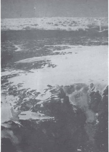
Fig. 3 The southern end of the Grinnell Ice Cap. The glacier entering Wynne-Edwards Bay in the foreground is retreating while that in the middle distance is advancing, 2 August 1953
From the seaward side of the ice cap, eight outlet glaciers descend. Four of these reach the sea; one (the Boas Glacier) flows northwards, the rest north-eastwards. None of them appears to be very active; only occasionally are small bergs calved. Comparison of a photograph of the Boas Glacier taken in 1897 by Russell PorterReference Porter 3 with one taken from the same place in 1952 shows an appreciable but not very great decrease in volume. In 1897 the glacier was approximately up to the top of what is now the lichen-free zone. Above this, there are traces of a much older moraine. This moraine is the only ancient one that was found on the peninsula, with the exception of a doubtful one in front of a corrie glacier. The seven glaciers flowing towards the north-east are all in retreat from a single set of very recent moraines, some, and possibly all, of which are ice-cored.
Along the southern margin, broad, lobate glaciers flow down into wide, shallow valleys. The largest of these, which is also the greatest in area of any of the outlet glaciers, was visited in 1952. It was found to be advancing over country that had been ice-free for a considerable length of time. The moraine-free cliffed terminus was advancing over lichen-covered rocks and mature heather communities. (Cassiope tetragona.) (Fig. 4, p. 652.) The advance appeared to be taking place by a mass of blue ice free from thrust-planes, pushing over white ice full of thrust-planes. The terminus of this glacier was at 320 m. (1050 ft.).
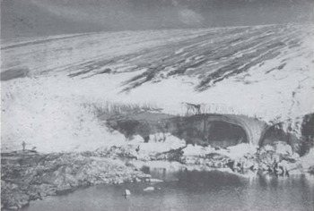
Fig. 4 Front of advancing glacier. 7 August 1952
The western edge of the ice cap is approximately linear, and lies between 520 and 580 m. (1706 and 1903 ft.). There are no glacier tongues ; the ice margin seems to be passive. No morainic material was visible along this flank of the ice cap, but the actual margin was hidden by snow drifts. The country to the west had a discontinuous covering of frost-riven material, but no true moraine.
The Terra Nivea Ice Cap
The Terra Nivea Ice Cap has about the same breadth as the Grinnell, but is half as long again, being 27 km. (17 miles) in length. The summit was not reached, but it appears to have about the same altitude. In character it is similar ; it also seems to be very thin. None of the outlet glaciers now reaches the sea, although two of them did so in the recent past ; and one only just fails to to-day. The most southerly glacier shows no evidence of recent retreat, but the rest have receded considerably from a single set of recent moraines.
The Relic Ice
The western margin of the Grinnell Ice Cap is at about 550 m. (1804 ft.). Inland, the land rises again in a series of low ridges to an estimated height of 700 m. (2296 ft.), and in the hollows are. several small masses of dead glacier ice. One of these is actually in contact with the ice cap. It slopes in the opposite direction, and in 1952 its surface of bare glacier ice contrasted strongly in appearance with the superimposed ice on the ice cap.
The Corrie Glaciers
There are several corrie glaciers along the coast between Cape Lawrence and Hall Bay. All those examined had receded moderately from a recent maximum extension, the moraines marking this extension being ice-cored.
The Economy Of The Grinnell Ice Cap
In 1952 the ice cap was reached on 23 July when it was entirely snow covered except for the outlet glaciers below about 550 m. (1804 ft.). At 628 m. (2060 ft.), near a small nunatak where a rain gauge was placed, there was 38 cm. (15 in.) of snow resting on ice at this date. Dowels were planted to see whether there was any further formation of superimposed ice ; but when the nunatak was next visited on 30 July, the snow had melted completely. By 20 August when the ice cap was last visited, areas up to 820 m. (2690 ft.) were bare. The firn boundary did not by any means follow a contour, but the three highest domes were still firn-covered. The summit of the northern dome, however, was bare.
At the same date on the western, inland, side of the ice cap, the developed firn line was at about 670 m. (2198 ft.) the surface from that level to the edge at 550 m. (1804 ft.) being covered with superimposed ice (Fig. 5, p. 652). The relic ice masses to the westward, all situated at altitudes above 550 m. had surfaces of bare glacier ice which contrasted strongly in appearance with the superimposed ice on the ice cap. The reason for this absence of superimposed ice is not clear, since the relic ice masses face towards the north-east and thus receive less insolation than does the adjacent ice cap. Possibly the superimposed ice on the ice cap is formed in part from melt water flowing down from higher levels, a source denied the relic ice masses.
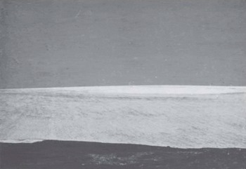
Fig. 5 The inland side of the Grinnell Ice Cap, showing surface of superimposed ire. View wtest from 1900 ft. 1 August 1952
Except for a few patches of snow or firn the surfaces of the relic ice masses were bare glacier ice on 1 August 1952; on 10 August 1953, however, they were still entirely snow covered. Although 1952 was a year of unusually heavy ablation, the absence of an accumulation area in that year indicates that these ice masses are bodies of dead ice.
All the ice that appeared at the surface above 550 m. (1804 ft.) on the ice cap seemed to be not ordinary glacier ice but superimposed ice.
Since it was not possible to make observations on its formation and subsequent ablation, there is bound to be some uncertainty on this point. However, on ascending any of the glacier tongues, there was a boundary between bare glacier ice below and a band of undoubted superimposed ice above ; this was very marked and was to be seen on the corrie glaciers also (Fig. 6, p. 652). This band of superimposed ice was narrow, and a short distance above was the developed firn line, and above this, the 1951 and 1952 temporary firn lines. Still higher, however, where the steep slopes of the outlet glaciers gave way to the much gentler slopes of the ice cap, there was once more ice at the surface. This ice was thus separated from the superimposed ice on the outlet glaciers by a belt of firn, but in colour and texture it resembled this superimposed ice and not the bare glacier surface lower down.

Fig. 6 Corrie glacier north-east of the President’s Seat, showing equilibrium line, developed firn line, and two temporary firn l vines . 21 August 1952
On the corrie glaciers two temporary firn lines, the developed firn line, and the equilibrium line (at the lower margin of the superimposed ice) were visible (Fig. 6). On the ice cap the two temporary firn lines were not distinguishable.
If the years 1951 and 1952 were normal years climatically it is evident that the Grinnell Ice Cap would have little or no permanent firn but would be nourished entirely by superimposed ice like the Barnes Ice CapReference Baird 4 . On I August 1952, however, a pit was dug in the firn on the summit to depth of 1.8 m. (6 ft.) before increasingly intractable ice bands prevented further excavation. This considerable depth of firn and the comparative stability of the developed firn line suggest that the latter is due to more enduring causes than a few years’ unusually heavy snowfall. Furthermore, parts of the ice cap had a surface of superimposed ice for at least a month in 1952. It seems almost certain that more than the previous spring’s accretion of ice was removed in that period, so that in 1952 the ice cap must have had a strongly negative budget. On the average, the superimposed ice areas must be subject to ablation for a much shorter period, and in individual years, e.g. 1953 they may remain snow-covered throughout the summer. That this is abnormal, however, is indicated by the fact that they are areas of net accumulation of superimposed ice and not of firn. On the evidence of the 1952 position of the developed firn line, the accumulation area of the Grinnell Ice Cap is divided approximately equally into a firn area and a superimposed ice area.
Snow conditions in 1953 were very different from those of the previous year. On Io August the entire ice cap was snow-covered except for the lower parts of the outlet glaciers ; on the western side there was no bare ice visible. On 13 and 14 August there was a heavy fall of snow at levels above 300 m. (984 ft.). On the corrie glaciers in contrast to the four boundaries that were visible in 1952 there was only one dividing bare glacier ice from the winter’s snow.
A study of the recorded annual snowfalls and summer temperatures in southern Baffin Island suggests that this great difference between individual years may be normal. It seems that summer temperature may have more effect on the economy than variations in the snowfall. At Frobisher in 1952 the average daily maximum temperature for May, June and July was 8° C. (46.5° F.) and the snowfall for the preceding winter was 376 cm. (148 in.). In 1953 the corresponding figures were 5.7° C. (42.3° F.) and 244 cm. (96 in.). If the climate on the Grinnell Ice Cap followed a parallel course, the coolness of summer 1953 must have more than compensated for the comparative dearth of snow during the preceding winter. However, it must be remembered that when superimposed ice plays a large part in the economy of an ice cap, the seasonal distribution of snowfall is important. A sparse snow cover will result in a greater penetration of winter cold into the upper ice layers than would a thick snow cover, other factors being equal. This will allow a greater thickness of superimposed ice to form in the following spring; in other words, the net accumulation year by year will vary less than the snowfall.
It is not known what the ice temperature at depth is on the Grinnell Ice Cap, since no borings were made, but the large amount of superimposed ice formed suggests that the winter cold wave penetrates deeply.
The present-day existence of the two ice caps with accumulation areas between boo and goo m. (1968 and 2953 ft.) seems anomalous. 400 km. (250 miles) to the south the Torngats which rise to 1500 m. (4920 ft.) support only diminutive corrie glaciers, and 400 km. to the north the firn line on the Penny Ice Cap appears to lie at 1500 m.Reference Ward and Baird 5 .
Presumably the Kingaite peninsula ice caps are favoured by cloudiness and low temperatures in summer, or by a high annual snowfall, or by a combination of these factors. Resolution Island off the tip of the peninsula has a July mean of 2.8° C. (37° F.), as low as anywhere in Canada, and 5° C. lower than at Frobisher airfield. Summer cloudiness is also very high, but since fog comes under the category of cloud, this may not apply at the greater elevations of the ice caps. Precipitation on the ice caps is probably considerable, 10.3 cm (4.1 in.) of rain having been measured in one month (23 July to 22 August) at a height of just over 610 m. (2000 ft.) on the Grinnell Ice Cap. This is nearly double the amount recorded at Frobisher at the same time, and higher than the record for any one month there or at Resolution Island.
On account of their area distribution the ice caps must be extremely sensitive to changes in the ablation season, and the absence of recessional moraines before the outlet glaciers indicates a fairly uninterrupted and slow shrinkage.


