1. INTRODUCTION
As an advanced maritime management concept, ship routeing is an effective management method implemented in heavy traffic waters. Practice shows that ship routeing plays a positive role in standardising traffic flows, reducing accidents and improving navigation efficiency. Heavy traffic in restricted areas requires special care for everyone involved in safe navigation (Squire, Reference Squire2003; Filipowicz, Reference Filipowicz2004). Traffic lanes and precautionary areas are two important routeing measures. Precautionary areas are generally set in the places where the traffic flow is complex, and the rate of collision is so high that vessels must navigate with particular caution. Precautionary areas have been a weak but important link in ensuring safe the ship routeing (Cockcroft, Reference Cockcroft1981; Goldwell, Reference Goldwell1983; Richey, Reference Richey1997). More than 280 ship routeing measures had been recognized by the International Maritime Organization (IMO) up until 2012, including 180 Traffic Separation Schemes (TSS). Ship routeing in China started late but is developing very fast. Sixteen ship routeing measures along China's coast and inland rivers have been applied, and the routeing system of the Cheng Shan Jiao promontory was recognised by the IMO. In December 2011, the Ministry of Transport of the People's Republic of China promulgated Overall Planning of Ships' Routeing Along the Sea of China and General Project of Sea Route of China. This is the first time that China has published an integrated plan of sea routes, which assigned 26 ship routeing measures and 78 main and branch sea routes. Owing to the successful management of traffic flow from a macro point of view, ship routeing contributed to a huge reduction in the number of ships’ dangerous encounters in traffic lanes, and brought great economic and safety related benefits. But the restriction and guidance of ship routeing makes many traffic flows converge in precautionary areas, which results in a high traffic density and complex flow directions. Consequently, the problem of ships’ dangerous encounters has become more serious in precautionary areas. All of these reveal that ship routeing cannot completely solve the problem of ships’ encounters in traffic lane intersections (Li and Xiao, Reference Li and Xiao2009).
The concept and definition of traffic conflict, related to measurement and validity, and the applicability of the technique have been extensively reviewed in literature (Chin and Quek, Reference Chin and Quek1997; Songchitruksa and Tarko, Reference Songchitruksa and Tarko2006). Traffic Conflict Technique (TCT) is based on the relations between the critical encounters and collisions. That is to say, TCT is an alternative to the collision-based safety analysis approach, which has been an important method of quantitative study on traffic safety, especially on road intersections (Minderhoud and Bovy, Reference Minderhoud and Bovy2001; Yang and Pu, Reference Yang and Pu2005). Both road and sea lane traffic have converged areas of traffic flows and many similarities exist in the precautionary area and the road intersection. For example, they are both at the crossing of channel and road; traffic flows are both heavy in all directions and the accidents occurring in these areas make up a large share of all accidents respectively.
There has been a large quantity of qualitative analysis, but only a few quantitative studies on the safety of precautionary areas. Navigational collision is one of the major safety concerns in precautionary areas, but the collision-based safety analysis approach is often hampered by lack of data samples (Debnath et al., Reference Debnath, Chin and Haque2011). A promising alternative is safety analysis using surrogate safety measures, where safety is assessed by analysing critical vessel conflicts. The concept of Navigational Traffic Conflict Technique (NTCT) was first proposed by Debnath and Chin (Reference Debnath and Chin2006). The same authors then provided a detailed description of NTCT and its mathematical formulation (Debnath and Chin, Reference Debnath and Chin2010). A number of researchers including Goerlandt and Kujala (Reference Goerlandt and Kujala2011) have reported that NTCT is a method developed for measurement of collision risks. As navigational traffic conflicts occur considerably more frequently than collisions, the key advantage of NTCT is having a larger database within a shorter period of time. Thus, NTCT is a theoretically appealing alternative to the traditional approach because of the fast, reliable and effective safety assessment. In an earlier paper (Li and Xiao, Reference Li and Xiao2009), we proposed the concept of using NTCT to study precautionary area safety. NTCT is a promising direction in studying the safety of precautionary areas and great benefits can be produced. With the support of Electronic Chart Display and Information Systems (ECDIS) and the Automatic Identification System (AIS), NTCT can collect the micro-data of a ship's collision risk and then use it to evaluate the safety of a precautionary area.
This technique can reduce conflict points in precautionary areas, decrease the conflict level and reduce the risk of ships’ dangerous encounter at the micro-level. The difference between NTCT and the International Regulations for Preventing Collisions at Sea, in general, is that the latter is the study of ships from ‘point-to-point’, and the former is the study of traffic flows in precautionary areas from ‘line-to-line’. Here ‘point to point’ refers to the relationship between the two ships, and ‘line to line’ refers to the relationships among the traffic flow in the precautionary area.
This paper aims to apply NTCT to the quantitative study of ship routeing precautionary area safety and to define a basis of further study on improving the dangerous ships’ encounter situation in precautionary areas. It can help to conclude a method to calculate the conflict points of traffic flows, develop an automatic acquisition system to collect vessel traffic conflict data for the quantitative analysis of the influence of single traffic flow on precautionary area safety, reduce the number of conflict points and relieve the chances of conflict. Thus the research can provide the foundation for optimising the geometric design and traffic organisation of precautionary areas.
2. CALCULATION METHOD OF NAVIGATIONAL TRAFFIC CONFLICT POINTS
If every traffic flow in a precautionary area is expressed as lines, a conflict point is a place where these lines cross, merge or diverge. The existence of conflict points is the reason for navigational traffic conflict. Unlike road traffic, the traffic flow in waterborne traffic cannot be controlled by the traffic signals and separated by time and space. So one of the main principles to improve precautionary area safety is to reduce conflict points.
2.1. Navigational traffic conflict points distribution of typical precautionary area
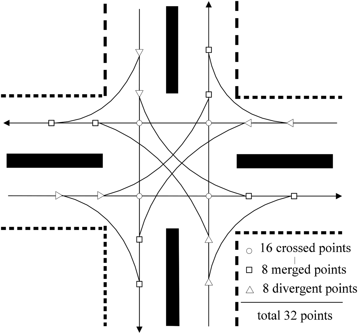
A precautionary area is a junction of several traffic lanes. The distribution of navigational traffic conflict points among different quantities of traffic lanes crossing is shown in Figure 1.

Figure 1. Number of navigational traffic conflict points of typical precautionary area.
The calculation equations of navigational traffic conflict points of traffic lanes are as follows, and n represents the number of traffic lanes here:
 $$\hbox{Crossed conflict points} = \displaystyle{{n^2 (n - 1)(n - 2)} \over 6}$$
 $$\hbox{divergent points} = \hbox{merged points} = n(n - 2)$$
From Equations (1) and (2), the critical factors that influence total number of conflict points is the number of traffic lanes crossed in the precautionary area.
2.2. Comparative analysis of the two editions of Yangtze estuary ships’ routeing (2002 edition and 2008 edition)
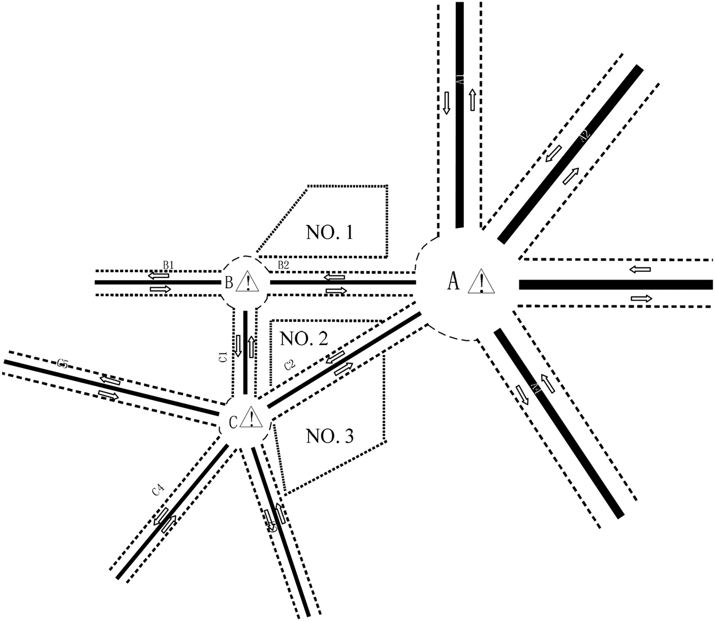
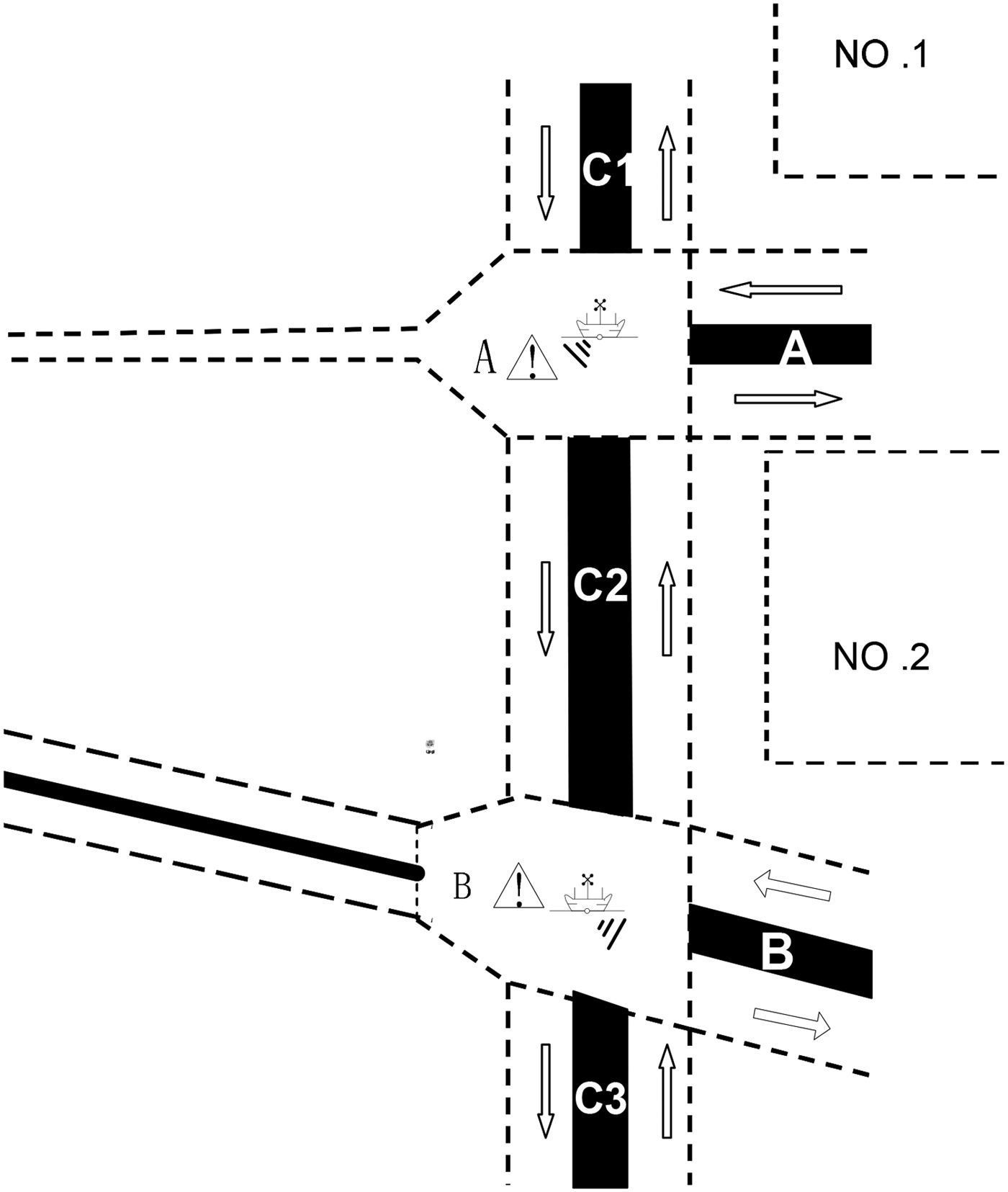
Yangtze estuary, the door of Yangtze River, is one of the most famous areas of crowded waters. 2002 edition and 2008 edition of Yangtze estuary ships’ routeing are shown in Figures 2 and 3.
Figure 2. Yangtze estuary ship routeing (2002).
Figure 3. Yangtze estuary ship routeing (2008).
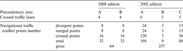
Since navigational traffic conflict points of ship routeing are mostly concentrated in precautionary areas, it is possible to perform the evaluations of different designs by the total number of conflict points in these areas. The time interval between the implementation of the two editions of Yangtze estuary ship routeing is not long. This ensures the similarity of traffic situations in these research areas and the validation of the comparisons on the two cases. According to Equations (1) and (2), the theoretical number of navigational traffic conflict points of Yangtze estuary ship routeing (2002 and 2008) is shown in Table 1.
Table 1. The theoretical navigational traffic conflict points number of Yangtze estuary ship routeing.
It is obvious that the total number of conflict points from the 2002 edition is four times more than that of 2008 edition. Of course, the actual number of conflict points reveals the deviation from the ideal calculation. For example, there are almost no left-turn or right-turn traffic flows in several traffic lanes. However, the theoretical conflict number can still be an important reference for optimising ship routeing.
3. REALIZATION OF AUTOMATIC NAVIGATIONAL TRAFFIC CONFLICT DATA ACQUISITION SYSTEM
Navigational traffic conflict data is the basis for analysing the mechanism of traffic conflict, assessing and improving traffic safety, and optimising project design. Collision risk reflects the degree of severity of navigational traffic conflict. Nevertheless, due to the vagueness and uncertainty of the collision risk, there is not currently any measurement that is generally accepted. Most research focuses on developing the methods of evaluating collision risk between two ships. Several papers have developed a probabilistic model of collision risk (Chin and Debnath, Reference Chin and Debnath2009; Goerlandt and Kujala, Reference Goerlandt and Kujala2011; Anderson and Lin, Reference Anderson and Lin1996). However, these existing methods do not have the capabilities of automatic collision risk statistics in specific waters. Thus they are difficult to apply well in practice.
Our solution for automatic acquisition of navigational traffic conflict data in precautionary areas is based on ECDIS, AIS and Support Vector Machine (SVM). The navigational traffic conflict parameter is firstly inferred by data from AIS. Then, a SVM classification model was acquired by training study of sample data and the conflict degree was identified by applying this model. Finally, the LIBSVM software package and SVM classification model were embedded in ECDIS, and the automatic acquisition system of navigational traffic conflict data was achieved combined with the real time data of AIS.
3.1. A brief introduction of the development environment
The development environment of the automatic acquisition system of navigational traffic conflict data are ECDIS, AIS, VC++ 6·0, MATLAB R2009a and the LIBSVM software package. The LIBSVM software package includes LIBSVM-2·91 and LIBSVM-MAT-2·89–3 with MATLAB connector.
3.2. The calculation of navigational traffic conflict parameter based on AIS data
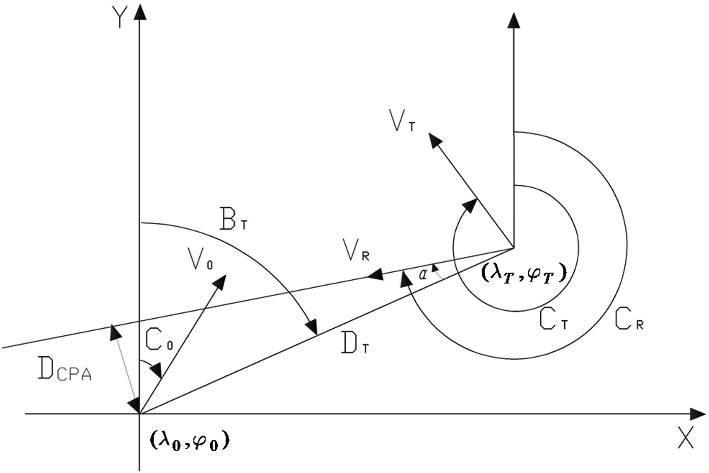
DCPA and TCPA are the two most important factors, which can be taken as navigational traffic conflict parameters (Figure 4).
Figure 4. Ship collision prevention geometric graph.
3.2.1. Distance and bearing algorithm of two encountered ships
It is supposed that λ 0, λ T, ϕ 0, ϕ T are longitudes and latitudes of two encounter vessels respectively, Dλ Dϕ are the longitude difference and latitude difference of two vessels’ location that can be calculated by Equation (3).
 $$\left\{ \matrix{D_\lambda = 60(\lambda _T - \lambda _o ) \cr D_\varphi = 60(\varphi _T - \varphi _o ) } \right.$$
For the convenience of calculation, between two ships, the vessel with bigger longitude is ‘other vessel’, ‘own ship’ is the one with smaller longitude. The true bearing BT(°) of other vessel relative to own ship can be calculated by Equation (4) and the distance DT (n mile) can be found from Equation (5).
 $$B_T = \arctan (D_\lambda /D_M ) + \tau $$
DM in Equation (6) is the meridional difference between other vessel and own ship, M is the meridional parts from Equation (7), and τ is circular azimuth adjust the parameter found from Equation (8).
 $$D_T = \left\{ \matrix{\left\vert {D_\varphi /\cos \,B_T} \right\vert \quad D_\varphi \ne 0 \cr \hskip-45pt\left\vert {D_\lambda} \right\vert & \hskip-52ptD_\varphi = 0 } \right.$$
 $$D_M = M\left( {\varphi _T} \right) - M\left( {\varphi _o} \right)$$
 $$\tau = \left\{ \matrix{0^{\deg} \quad D_\lambda \ge 0,\,D_\varphi \ge 0 \cr 180^{\deg} \quad D_\varphi \lt 0 \cr 360^{\deg} \quad D_\lambda \lt 0,\,D_\varphi \ge 0 } \right.$$
 $$M(\varphi ) = 7915.70447 \cdot \lg \left[ {\tan \left( {\displaystyle{\pi \over 4} + \displaystyle{\varphi \over 2}} \right)} \right] - 23.0\sin (\varphi )$$
3.2.2. Relative course and speed of two vessels and the algorithm of DCPA and TCPA
V 0,V T, C 0,C T are supposed as speed (Kn) and course (°) of own ship and objective ship respectively. V 0x,V Tx,V 0y,V Ty stand for the speed components (Kn) on X-axis and Y- axis of own ship and objective ship which can be obtained by Equation (9).
 $$\left\{ \matrix{V_{ox} = V_0 \cdot \sin (C_0 ), & V_{Tx} = V_T \cdot \sin (C_T ) \cr V_{oy} = V_0 \cdot \cos (C_0 ), & V_{Ty} = V_T \cdot \cos (C_T ) } \right.$$
Relative speed of target vessel V R (Kn) can be determined by Equation (10), and relative course C R (°) can be calculated by Equation (11) where β is circular heading adjust the parameter obtained from Equation (12).
 $$V_R = \sqrt {(V_{Ty} - V_{Oy} )^2 + (V_{Tx} - V_{Ox} )^2} $$
 $$C_R = \arctan \left( {\displaystyle{{V_{Tx} - V_{Ox}} \over {V_{Ty} - V_{Oy}}}} \right) + \beta $$
 $$\beta = \left\{ \matrix{0^{\deg} \quad V_{Tx} - V_{ox} \ge 0,\,V_{Ty} - V_{oy} \ge 0 \cr 180^{\deg} \quad V_{Tx} - V_{ox} \lt 0,\,V_{Ty} - V_{oy} \gt 0 \cr 270^{\deg} \quad V_{Tx} - V_{ox} \ge 0,\,V_{Ty} - V_{oy} \lt 0 \cr 360^{\deg} \quad V_{Tx} - V_{ox} \lt 0,\,V_{Ty} - V_{oy} \ge 0 } \right.$$
The distance to closest point of approach (D CPA) (n mile) and the time to closest point of approach T CPA (min) between own ship and target ship can be calculated by Equation (13), where α is the included angle between relative movement line and other vessel's bearing line, which can be obtained from Equation (14).
 $$\eqalign{& D_{CPA} = D_T \cdot \sin (\alpha ) \cr & T_{CPA} = \displaystyle{{D_T \cdot \cos (\alpha )} \over {V_R}}} $$
 $$\alpha = \left\vert {C_R - B_T + 180} \right\vert$$
The classification of navigational traffic conflict degree in this paper is from the third- person point of view to consider the relations of two ships. So own ship and other vessels are not set, and the values of DCPA are all positive. The values of TCPA need to differentiate plus-minus to reflect whether two ships pass the closest point of approach. So α calculated by Equation (14) should be dealt with by Equation (15).
 $$\left\{ \matrix{\alpha = \alpha - 360,\quad \alpha \ge 360 \cr \alpha = 360 - \alpha, \quad 360 \gt \alpha \ge 180 \cr \alpha = \alpha, \quad \quad 180 \gt \alpha \ge 0 } \right.$$
3.3. Construct the classification model of navigational traffic conflict degree
3.3.1. Acquisition of navigational traffic conflict samples
From the ECDIS, the case of ships’ dangerous encounters in the precautionary area and the AIS data of latitude, longitude, speed and course can all be obtained and recorded. An expert committee with rich navigation experience estimated the dangers of ships’ encounter and sorted them into four types of non-conflict, general conflict, medium conflict and serious conflict. For each type of the encounter, conflict parameters of DCPA and TCPA were collected. Finally, 128 effective navigational traffic conflict samples were obtained. The 128 conflicts are samples of ships’ dangerous encounters randomly between different vessels, also at different heavy traffic waters, at different time points.
3.3.2. SVM classification model
Kernel Function is one of the Radial Basis Functions (RBF), which is used most widely in SVM. The parameter selection of Kernel Function has a significant influence on the function of SVM. There are two parameters in Kernel Function: the penalty parameter c and the kernel parameter g. The optimisation parameters c and g will make the SVM have the best performance. Cross Validation (CV) is a technique for estimating the performance of a predictive model. Cross Validation can select parameters well, and the steps to create the model are as follows:
(1) 128 navigational traffic conflict samples were grouped and 64 samples among them were randomly selected as the training set; the rest of the samples were taken as the checking set.
(2) Install libsvm-mat-2·89–3 in the MATLAB R2009a. The parameter of the SVM classification model can be obtained by using the CV method. When the penalty factor c reaches eight, g is 2·83, the True Positive Rate (CV Accuracy) can reach 97·5% (Figure 5).
(3) Save the SVM classification with the optimal parameter as a file, and construct the SVM classification model of navigational traffic conflict degree.
Figure 5. Classifier True Positive Rate as a function of c and g parameters.
3.4. Realisation of automatic traffic conflict data acquisition
By embedding the LIBSVM software package and SVM classification model in ECDIS and making connections with AIS, the system of automatic acquisition of navigational traffic conflict data in a precautionary area can be determined.
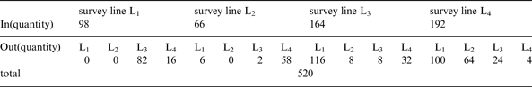
The system can evaluate navigational traffic conflict every 30 seconds. It is noted that a large number of results may be obtained during this period. We may get three navigational traffic conflict datasets between two ships, corresponding to general conflict, medium conflict and serious conflict respectively. In this case, if the severity levels are the same, we only retained the result with the minimum distance. So we just get the maximum number of navigational traffic conflict datasets. Finally, we choose the highest severity datasets as the navigational traffic conflict. The time, longitude and latitude coordinates, Maritime Mobile Service Identity (MMSI), speed and course are recorded and displayed on the ECDIS. Meanwhile, the survey line set on every traffic flow in the precautionary area records the ship traffic volume.
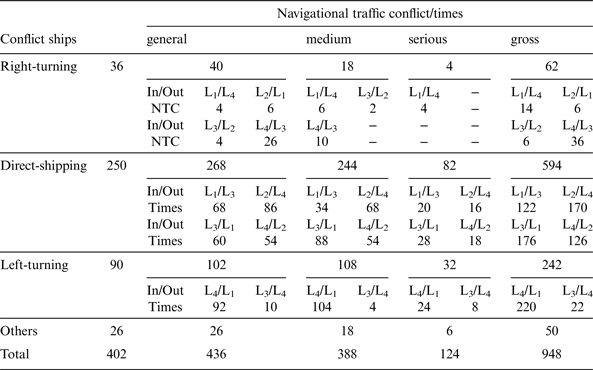
This system was applied to acquire the navigational traffic conflict data of the Yangtze estuary ship routeing precautionary area B. 48-hour records are shown in Figure 6. The system recorded the traffic flow in the survey line, the histogram height is the ship traffic volume, histogram direction is the direction of traffic flow and the detailed data is shown in Table 2. The triangles, rectangles and circles in Figure 6 respectively stand for general, medium and serious traffic conflicts. Since the detailed parameters of every navigational traffic conflict were recorded, statistical analyses can be performed precisely. According to the shipping track, the conflict ships can be sorted into left-turning, right-turning, direct-shipping and others. The statistics are in Table 3.
Figure 6. Traffic flow and distribution of traffic conflicts of Yangtze estuary ships’ routeing precautionary area B over 48 hours.
Table 2. The conflict flow of Yangtze estuary ships’ routeing precautionary area B over 48 hours.
Table 3. The navigational traffic conflict classified by shipping track of Yangtze estuary ships’ routeing precautionary areas B over 48 hours.
Note: The conflict in the table is counted by single ship, that is to say, one conflict is counted as two data sets.
4. APPLICATION OF THE NAVIGATIONAL TRAFFIC CONFLICT DATA
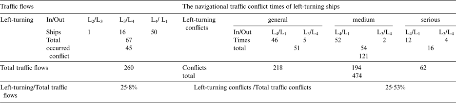
The traffic flow impact on the overall traffic safety in the precautionary area can be analysed by collecting the volume of traffic flow and conflict data. The left-turning ships have a long track in the precautionary area, such as the Yangtze estuary ship routeing precautionary areas A and B, and pass more conflict points. This essay analysed the effect of left-turning traffic flows on the overall traffic safety of the Yangtze estuary ship routeing precautionary area B quantitatively. From Table 3, left-turning traffic flows and the proportion of their conflicts to the total traffic conflicts in precautionary area B can be further counted and are shown in Table 4.
Table 4. Left-turning traffic flows and the proportion of their conflicts to the total traffic conflicts in Yangtze estuary ships’ routeing precautionary area B.
From Table 4, among 67 left-turning ships of the left-turning flows, 45 ships experienced a traffic conflict, which makes up 25·8% of total traffic flows. Left-turning conflicts account for about a quarter of the total conflicts. The left-turning traffic conflicts are generally in direct proportion to the total conflicts, and have no obvious impact on the increase of traffic conflicts. Moreover, the proportion of left-turning ships and the number of their traffic conflicts to the total traffic flows and the total conflicts is not large, so further traffic measures do not need to be taken for this situation. Here we only quantitatively analyse the influence degree of a single traffic flow on the whole precautionary area traffic safety.
5. CONCLUSIONS
This article is aimed at the problem of ship encounters in precautionary areas that is not solved well by the traffic separation scheme during the process of integrally planning and networking of ship routeing along the sea in China. In the consideration of the similarity between the ship routeing precautionary areas and road intersections, traffic conflict technique was introduced in the precautionary area. This paper analysed the feasibility of application of traffic conflict technique in precautionary areas, discussed the calculation methods of navigational traffic conflict points, developed the automatic acquisition of navigational traffic conflict data system, and applied the data in the quantitative analysis of the influence degree of single traffic flow on the whole precautionary area. The above efforts help to establish a system of studying the precautionary area traffic safety based on NTCT, and provide a new way to quantitatively study ship routeing precautionary areas. The proposed method can also assist in designing optimised ship routeing schemes. In brief, the similarity of process between navigational traffic conflict and collision and the rapidity of acquiring data makes the NTCT an important way of studying the safety of ship routeing precautionary areas.
ACKNOWLEDGEMENTS
This research was sponsored by Ningbo Natural Science Funds (Project No.: 2013A610282), and by K.C.Wong Magna Fund in Ningbo University, the People's Republic of China.