Introduction
In many aspects, ice shelves playa very important role in the Antarctic environment. They are the main drainage areas for the West Antarctic ice sheet, thus controlling the mass balance of the ice sheet and participating in its dynamics (Reference Doake and VaughanDoake and Vaughan, 1991). On the other hand, it is the ice-shelf ocean interaction which plays an important role in forming the bottom water of the world’s ocean (Reference Fahrbach, Knoche and RohardtFahrbach and others, 1991). Ice-shelf movement, as well as ocean-circulation systems and climate change, have been described by numerical models (e.g. Reference DetermannDetermann, 1991; Reference Hellmer and OlbersHellmer and Olbers, 1991; Reference Jenkins and DoakcJenkins and Doake, 1991; Reference HuybrechtsHuybrechts, 1992; Reference Jacobs, Hellmer, Doake, Jenkins and FrolichJacobs and others, 1992), which, however, depend on field measurements for calibration and validation purposes. Physical properties of the ice shelves (e.g. Reference OerterOerter and others, 1992; Reference Eicken, Oerter, Miller, Graf and KipfstuhlEicken and others, 1994) are needed as well as ablation and accumulation rates at the ice-shelf bottom (e.g. Reference GrosfeldGrosfeld, 1993). The ocean currents are driven by the thermohaline conditions, and therefore measurements of salinity and seawater temperature are needed (e.g. Reference Nicholls, Makinson and RobinsonNicholls and others, 1991) and especially current velocities which, however, were only once determined beneath an ice shelf (ØReference Østerhus, Orheim and Oertersterhus and Orheim, 1992).
Compared with the two largest ice shelves in Antarctica, Ross and Filehner-Ronne Ice Shelves, Ekströmisen (Fig. 1) is small (8700 km2) and therefore it plays a minor role in the framework of global-change considerations. Nevertheless, the principal physics of ice shelves are independent of their areal extension and the wintering-over base Neumayer on Ekströmisen is quite easily accessible and therefore an optimum area for testing drilling equipment and various measuring devices, as well as starting pilot studies.

Fig.1 . Map of Ekströmisen (after Institut Jür Angewandte Geodäsie, 1989). The drill site was located adjacent to the geophysical observatory of the German wintering-over base, Neumeyer
The Hot-Water-Drilling Equipment
A proper means for penetrating ice bodies even to depths of several hundreds of meters is hot-water drills, as has been proven by several field studies (e.g. Reference Engelhardt and DetermannEngelhardt and Determann, 1987; Reference Nicholls, Makinson and RobinsonNicholls and others, 1991; Reference Iken, Echelmeyer, Harrison and FunkIken and others, 1993). These hot-water drills enable a fast penetration rate but they need a tremendous logistic back-up. The hot-water drill developed at AWI consists of six modified high-pressure cleaners, one winch-drum, the controlling electronics of the electrical winch, comprising display of hose tension as well as drilling speed and depth of the nozzle. The water needed is produced by melting snow in a water tank. Several pumps are used to supply the high-pressure heat exchangers and to recover used water from a separate hole in the firn, that reduces the energy needed for melting snow. Thus, more heat can be used for drilling. The capacity of the heat exchangers is 750 kW, and the maximum capacity of the high-pressure pumps is approximately 90 1 min -1. The drilling speed is controlled by the winch electronics, dependent on which are the total weight of the hose and drill head, Thus, it can be ensured that the nozzle never touches the borehole bottom. Gravity always forces the nozzle to hang freely in the borehole, and a vertical borehole will be melted. This is necessary to enable undisturbed access to the borehole for water sampling and borehole logging.
Drilling During The 1993 Field Season
During the 1993 field season, the hot-water drill described above was used to penetrate the approximately 240 m thick Ekströmisen three times. The drill sites were located adjacent to the geophysical observatory of the German over-wintering base, Neumayer. The geometry of the boreholes was determined with the aid of a caliper and inclination sonde. Immediately after drilling, the diameter was at least 35 cm and the inclination of the borehole deviated not more than a few degrees from the vertical. The time used for drilling itself was 12 d; a total of 46 d was needed to get started and finished with installing all measurement devices. The fuel consumption totalled 14 tonnes of diesel and 4 tonnes of gasoline.
One of the three boreholes was used to install an ultrasonic echo-sounder approximately 11.5 m below the ice-shelf bottom. The orientation of the sounder is upwards. For given time intervals, it determines its distance to the bottom of the ice shelf. Thus, subglacial ablation or accumulation can be recorded directly. The data arc recorded at the geophysical observatory. A second hole was used to install a temperature string, with 11 thermistors, through the ice shelf The data are transmitted via ARGOS to Bremerhaven. Through the third hole, a pressure gauge was lowered to the sea bottom for recording tides, and a one-conducter cable with two temperature sensors was lowered to the ocean bottom. Before these installations were completed, the holes gave access to the ocean for six consecutive CTD profilings and water samplings. Two different water samplers were used on the same cable, providing 150 ml and l.51 samples, respectively. A schematic drawing of the complete arrangement is shown in (Fig. 2)

Fig.2 . Block diagram of the measuring devices in hot-water-drilled boreholes and underneath the ice shelf.
First Results
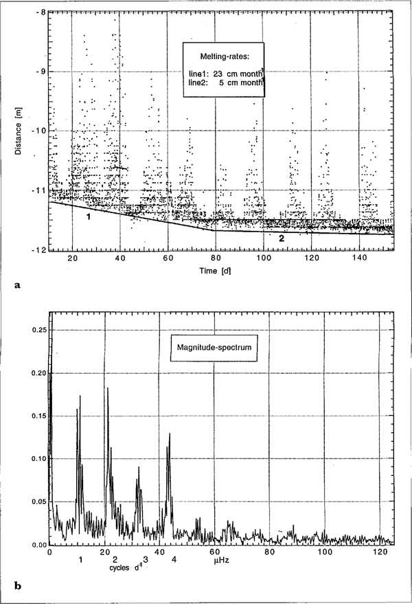
Figure 3a shows the variation of the distance between the echo-sounder and the ice-shelf bottom over a period of 154 d from 1 March to 1 August 1993. The distance varies considerably between 8 and 11.7 m. These oscillations may be caused by obviously strong tidal currents entering beneath the ice shelf and moving the sounder along the vertical. By this movement, the distance to the ice-shelf bottom varies periodically, and will be dependent on the square of the speed of the sea-water current. An analysis of the frequency distribution of the distance variations (Fig. 3a) results in the spectrum of amplitudes given in Figure 3b. Evident are daily periods of 24, 12 and 6 h, and with lower amplitude a period of 8 h; a fortnightly period can also be seen. This means that the distance between echo-sounder and ice-shelf bottom varies with tidal frequencies; there is very little energy on other frequencies. This proves directly the existence of tidal currents underneath the ice shelf and that the echo-sounder follows the tide current. As the motion of the echo-sounder beneath the ice shelf is complex,we deduce the melting rates from the variation of the maximum distances as a first-order approximation. Though one cannot rule out the possibility that long-period changes in the tidal current may induce a change in slope of the base line, we interpret this change in slope as varying melt rates under Ekströmisen. Seasonally varying melt rates have also been reported at other locations near ice fronts (Reference Grosfeld, Blindow, Thyssen and OerterGrosfeld and others, 1992). These “linear fits” are shown as lines I and 2 in (Fig. 3a). The different slopes result in ablation rates of 23 cm month 1 during March and April and of 5 cm month -1 from May to August. Thus, the melting rate close to the ice front (Fig. 1) shows a distinct variation with higher ablation in summer and lower ablation in winter. The deduced values of ablation agree quite well with model results calculated for the marginal area of Ekströmisen due to energy-balance considerations (Reference KipfstuhlKipfstuhl, 1991). Thus, this ultrasonic echo-sounder provides a method for direct ablation measurements and makes another valuable contribution to the mass-balance calculations of ice shelves. Furthermore, it should be possible to use the displacement of the echo-sounder to calculate the speed of these currents, if it has once been calibrated under defined conditions.

Fig.3 . Recorded distances between an echo-sounder underneath Ekströmisen and the ice shelf bottom. The variations of the distance are due to displacement of the sounder by tidal currents. The deduced ablation rate varies between 23 cm month-1 in “summer” and 5cm month-1 in “winter”. b. Spectrum amplitudes of the variations of recorded distances between an echo-sounder and the ice-shelf bottom (see Fig. 3a).
The influence of the tidal currents is also recognizable from the temperature data of the CTD profiles (Fig. 4a). Qualitatively, the sequence of the six profiles behaves similarly. The coldest water body with-in one case-a temperature below -2.0°C appears closest to the ice shelf; immediately after the drilling had been completed. Afterwards, the temperature increases and decreases from minimum temperatures below 1.90°C to maximum temperatures above -1.85°C within a depth range between 200 and 260 dbar. Below 260 dbar, down to the sea bottom, a slightly increasing temperature is observed. The vertical width of the warm-water body, as well as the depth of the maximum temperature, varies with time. An explanation might be that, with the tidal current, relatively warm water flows under the ice shelf from the sea-ice-covered areas in front of and within Atka iceport. The salinity of the sea water under the ice shelf shows little variation (Fig. 4b) but increases with depth. The water samples taken through the boreholes are still under analysis for δ18O content and various nutrients. The results will enable a further description of the water masses and conclusions about their origin

Fig.4 . Temperature profiles underneath Ekströmisen from 19 January, 1850 h to 20 January, 0610 h. b. Salinity profiles underneath Ekströmisen from 19 January, 1850 h to 20 January, 0610 h. Salinity variations within the borehole are due to vertical water flow induced by the continuously operating submersible pump in the cavern (Fig. 2) and reaming of the borehole with fresh water between the CTD runs.
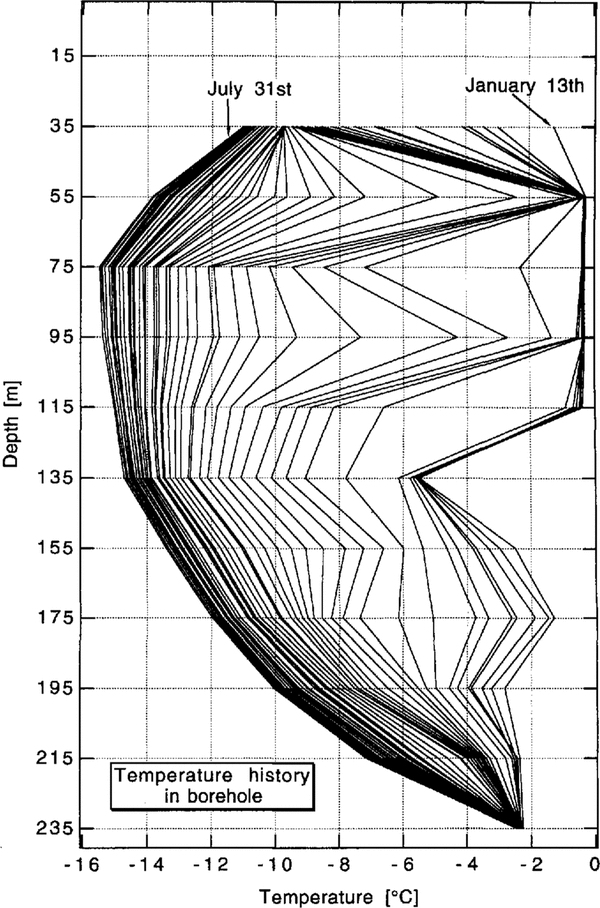
The temperature profiles of the ice shelf, as measured with the aid of the temperature string at several times, arc displayed in (Fig. 5) The horizontal lines indicate the depths of the thermistors (except 15m), each curve representing one set of measurements. One day after the drilling was finished, the temperature in the borehole was close to and even below the melting point. Almost 3 months are needed until the remaining heat of the hot-water drilling is drawn off and an undisturbed temperature profile (Reference GrosfeldGrosfeld, 1993) is observed. This enables a qualitative study of the heat conductance in the ice shelf, as well as an estimate of the ice volume influenced by the hot-water drilling. The lowermost thermistor is still surrounded by ice. It will be melted out within the next year and so a second possibility for ablation measurement is available.

Fig.5 . Temperature distribution throughout Ekströmisen. The thermistor string is inserted in a hot-water drilled hole, drilled in January 1993
Acknowledgements
Such a drilling operation can only be successful with good team work. Therefore, the authors would like to express gratitude to all who helped in preparing and carrying out the field work.