


Introduction
Glacier changes are among the clearest signals of ongoing warming trends existing in nature. In view of today’s rapid environmental changes, combined with the high thermal sensitivity of Earth’s mountain glaciers, detailed, repeated and up-to-date information on any glacierized region of the world is of growing interest. Space- and airborne remote sensing and geo-informatics play an important role in such glacier inventorying and monitoring work. Steps are now being taken to make worldwide glacier monitoring part of the Global Terrestrial Observing System (GTOS) of the World Meteorological Organization, the International Council of Scientific Unions, the United Nations Food and Agriculture Organization, the United Nations Environment Programme and UNESCO. Such a worldwide collection of standardized observations includes repeated compilation of statistical information on the distribution and topographic characteristics of perennial surface ice in space (glacier inventories). Glacier inventory work is repeated at time intervals comparable to characteristic dynamic response times of mountain glaciers (a few decades), and helps with analyzing and assessing changes at a regional scale (e.g. Reference Haeberli and HoelzleHaeberli and Hoelzle, 1995; Reference Haeberli, Cihlar and BarryHaeberli and others, 2000).
The highest information density and most complete historical record of glaciers exists in the European mountain ranges. In Switzerland, a complete glacier inventory was compiled from aerial photography taken in 1973 (Reference Müller, Caflisch and MüllerMüller and others, 1976). This inventory was revised in detail and completed with a reconstruction of the 1850 glacierization (Reference Maisch, Wipf, Denneler, Battaglia and BenzMaisch and others, 1999). Comparison of the two databases together with long-term observations at individual sites and regional studies using more recent imagery indicates major mass losses with an acceleration tendency in the last 20 years. The time has now come to compile a new glacier inventory for the Swiss Alps. This task fits into the U.S. Geological Survey (USGS)-led Global Land Ice Measurements from Space (GLIMS) project for worldwide glacier mapping, using satellite imagery in combination with digital elevation information. GLIMS is to compile, for the first time, a global remote-sensing-derived inventory of land ice masses. Connected to this project, a new Swiss glacier inventory for approximately the year 2000 (SGI 2000) is based on the Landsat 5 Thematic Mapper (TM). Later, Landsat 7 Enhanced Thematic Mapper Plus (ETM+), Système Probatoire pour l’Observation de la Terre (SPOT) imagery, Indian Remote-sensing Satellite (IRS) and aerial imagery and also ASTER images (Advanced Spaceborne Thermal Emission and Reflection Radiometer on board Terra) will be applied. This work continues the long Swiss tradition of glacier monitoring, but also serves as a GLIMS pilot study.
Notes: Primary data represent the original input; secondary data are automatically derived from the primary data within a GIS. Various on demand parameters can be derived automatically for special purposes, but are not included in the database. 2-D, two dimensional; 3-D, three dimensional.
In view of this global perspective, it was decided not to use aerial photogrammetric approaches (cf. Reference Würländer and EderWürländer and Eder, 1998) for SGI 2000, but to develop and apply remote sensing and geographical information system (GIS) technology suitable for glacier inventorying over large areas. Although of much greater spatial resolution, glacier inventories derived from aerial photogrammetry do not allow for a high degree of automated glacier detection because of the panchromatic information. They are more costly and time-consuming and substantially restricted by the availability of suitable aerial photography. Space-borne remote sensing, on the other hand, is the only technology suitable for standardized global glacier inventorying and monitoring.
Part I of this contribution (Reference PaulPaul and others, 2002) describes the evaluation of remote-sensing algorithms for automatic glacier detection, the selection of remote-sensing procedures suitable for SGI 2000, and the fusion of the classification results with digital elevation models (DEMs) using GIS technology towards the SGI 2000 database. Here, in part II, we present regional examples of SGI 2000, and a first comparison of SGI 2000 with the 1973 inventory and an intermediate 1985 stage.
Glacier Inventory
The basic entries of SGI 2000 (Table 1) are
Table 1. Glacier parameters of the SGI 2000 database
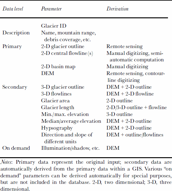
(1) the individual glacier identification (ID),
(2) planimetric glacier outlines as derived from image analysis,
(3) manually (or semi-automatically) digitized central flowlines,
(4) polygonal glacier basin maps.
The polygons of glacier basin maps broadly surround the actual glaciers, but are also used to separate contiguous ice masses into individual glaciers, typically along firn divides as estimated from DEM information within the 1973 inventory. Thereby, the glacier ID (1) is connected to the corresponding polygon of the glacier basin map (4). The planimetric glacier outlines (2) are, besides some pre- and post-processing procedures, deduced by thresholding ratio images of Landsat 5 TM bands 4 and 5, or equivalent bands of other sensors (Reference PaulPaul, 2001; Reference Paul, Kääb, Maisch, Kellenberger and HaeberliPaul and others, 2002). For the results presented here, TM scenes of 12 September 1985 and 31 August 1998 were used. Central flowlines (3) were assessed within the 1850 and 1973 inventories (Reference Maisch, Wipf, Denneler, Battaglia and BenzMaisch and others, 1999), and digitized from the inventory maps. Automatic delineation of center lines from DEMs was tested by F. Keller (Reference HaeberliHaeberli and others, 1999a; personal communication from F. Keller, 1997) based on tracking maximum local slope direction. It was found that a number of operator interactions would be necessary to ensure acquisition of consistent flowlines without gross errors. From the above works, however, we conclude that a semi-automatic approach is promising for large areas with an accurate DEMavailable.
Figure 1 shows the remote-sensing results for a test region in the Swiss Alps (Mischabel range; approximately 7°50’ E, 46°5’ N). Here, we briefly point out some phenomena, typical also for other regions of the inventory. We want to stress that the depicted stages of 1973 (digitized inventory), 1985 and 1998 (both satellite-derived) represent only three points in time of continuous glacier evolution. Conclusions for the entire development between 1973 and 1998 must therefore be drawn carefully. For Findelengletscher a clear retreat of the terminus and lateral zones is evident. Even some parts of the glacier bed within the glacier became free of ice. The northern parts of Feegletscher also experienced significant area loss, with the tongue retreating not only longitudinally, but even more laterally. This mass loss was partially accompanied by increase of debris cover which was then mis-classified as non-glacier, thus leading to apparent but not actual glacier retreat. The southern parts of Feegletscher show an advance between 1973 and 1985, as observed for many Swiss glaciers around the 1980s (Reference Herren, Hoelzle and MaischHerren and others, 1999). This advance is followed by a significant retreat between 1985 and 1998. The southern parts of Feegletscher are comparably steep and the ice is estimated to be thin, both resulting in a sensitive relation between mass balance and area change, in that a given thickness loss leads to a comparable strong horizontal retreat for geometric reasons. At Allalingletscher (scene of a catastrophic ice avalanche in 1965) a drastic slide of the tongue occurred shortly before the 1985 satellite image acquisition. Since then, the glacier has retreated to its preslide extent. The northwestern part of Schwarzberggletscher is debris-covered, and thus not classified as ice from the satellite imagery. The tongue of this glacier ends above a steep edge, stabilizing the lower extent. Finally, most small glaciers in the region drastically diminished or even totally disappeared in the time period observed (see next section).
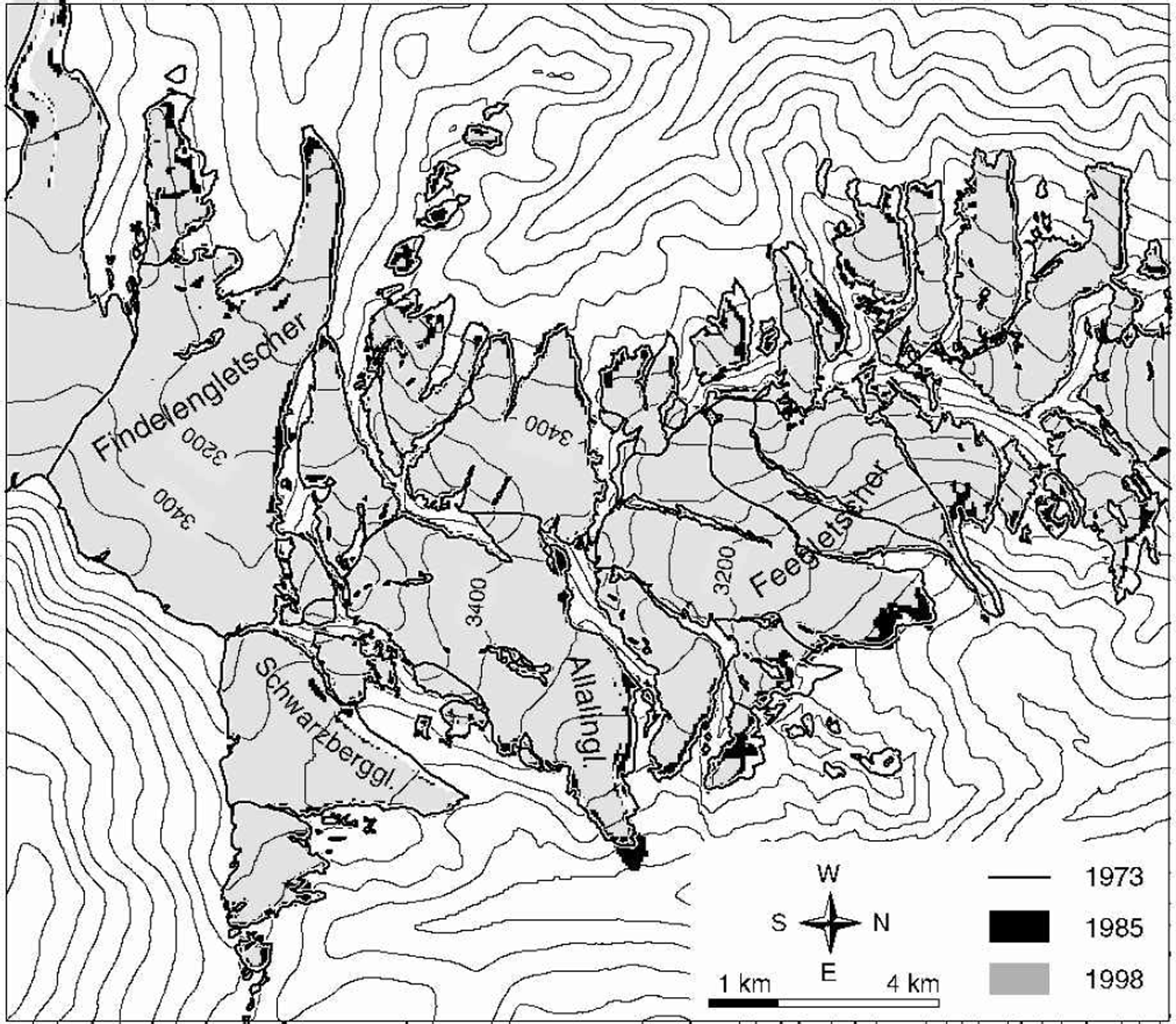
Fig. 1. Mischabel range, Valais, Swiss Alps. Glacier outlines from the 1973 inventory (Reference Maisch, Wipf, Denneler, Battaglia and BenzMaisch and others, 1999), and glacier areas for 1985 and 1998 as automatically deduced from Landsat TM imagery. As well as a general glacier retreat trend, the 1980s advance period can be recognized for some glaciers. Detecting debris-covered ice is a major problem, however.
The major problem for deriving glacier extents from satellite imagery (also affecting the results in Figure 1) is presently to detect debris-covered ice. In the concluding section, we sketch out some possible remote-sensing solutions for that problem. Here, we classify the glaciers as debris-free or significantly debris-covered. Debris-free is defined in terms of the classification by the applied remotesensing algorithms. Since the mass balance of debris-covered glaciers, or glacier parts, is different from that of debris-free ones, a separation of both types in the inventory and subsequent analyses is advisable in any case. It is also doubtful whether reliable tracking of area changes of debris-covered glaciers is possible. Fluctuations of debriscovered Swiss glaciers are not considered for the first inventory analysis presented here.
From the primary inputs such as 2-D glacier outline, 2-D flowlines, 2-D glacier basin map and DEM, a number of secondary parameters are derived automatically, either directly from the primary data and/or after combining the planimetric data with a DEM(Table1). For SGI 2000 we used the 25 m spaced DEM of the Swiss Federal Office of Topography, which in general was of suitable precision. A major problem, however, is that the DEM is collected from aerial photography over a longer time period, and thus does not reflect a well-defined point in time, and in any case does not coincide with the time for the satellite imagery used. This error mainly affects the parameter minimum glacier elevation. All parameter- derivation procedures are performed within the GIS Arc/Info (Reference PaulPaul and others, 2002).
Figure 2a and b depict, respectively, the share of glacier number within different area-size classes compared to the total number of Swiss glaciers, and the share of glacier area within the area classes compared to the total glacierized area. As is well known, and reflecting general characteristics of alpine-type glacierization, most glaciers are small, and cover a small total area (cf. Reference Maisch, Wipf, Denneler, Battaglia and BenzMaisch and others, 1999; Reference Paul, Kääb, Maisch, Kellenberger and HaeberliPaul, 2002). Nonetheless, small glaciers, which are not included in most monitoring networks, cover a significant total area. Note that glaciers of area 0.01–1km2 sum up to 25% of the glacierized area (Fig. 2b). The raw inventory data were used to compute the percentages, and some small glaciers were combined with larger ones, as is occasionally done in glacier inventorying.

Fig. 2. Glacier number and area size classified by different area classes (in km2) as percentage of the total number (a), or total area (b), respectively. The numerous small glaciers of area <1km2 cover about 25% of the total Swiss glacierized area.
Glacier Changes
First results of glacier changes derived from the 1973 Swiss inventory and observed from 1985 and 1998 satellite imagery were computed for a sample of about 300 debris-free glaciers of the Bernese and Valais Alps. Whether a glacier is debris-covered or not was decided on visual inspection of the applied satellite imagery. The large glaciers of the region are not included since they all show significant debris cover. Thus, the sample analyzed here can be viewed as representative for glaciers of area<10 km2. Figure 3 shows the percentage area loss of the sample between 1973 and 1998, additionally averaged for the area-size classes used in Figure 2. As expected and already found by other authors (e.g. Reference Maisch, Wipf, Denneler, Battaglia and BenzMaisch and others, 1999; Reference Serandrei Barbero, Rabagliati, Binaghi and RampiniSerandrei Barbero and others, 1999; Reference Paul, Kääb, Maisch, Kellenberger and HaeberliPaul, 2002), the smaller the glaciers are, the larger is the variance of their relative area change. This relation might reflect the larger sensitivity of small glaciers to the local variability of processes involved in glacier mass balance, but is also influenced by the highly individual reaction of small glaciers to external forcing (cf. Reference Haeberli and HoelzleHaeberli and Hoelzle, 1995; Reference Herren, Hoelzle and MaischHerren and others, 1999). The fast reaction leads to the effect that the area of small glaciers as mapped from one inventory snapshot only reflects the mass balance of a few preceding years. The larger glaciers’ change more likely represents the average change between two inventory snapshots. In that context, the very different time periods investigated here must also be considered. Whereas the period 1850–1973 might exceed the response time of all investigated glaciers, the 1973– 85–98 periods might not do so for a number of glaciers. Furthermore, the smaller the glaciers are, the worse becomes the signal-to-noise ratio from detection and processing (e.g. due to limited pixel size) and thus the variance of the sample.

Fig. 3. Area changes 1973–98 for a subsample of debris-free glaciers in the Valais and Bernese Alps. Large glaciers 410 km2 are excluded because of their (often high) debris coverage. The changes are averaged for the area classes shown in Figure 2 (bold line). The smaller the glaciers, the larger the variance of their behaviour and the higher their average percentage area loss.
Figure 4 summarizes the area changes of the test set of debris-free glaciers for the periods 1973–85–98 for the individual glacier area classes. The 1850–1973 area changes were added for comparison from Reference Maisch, Wipf, Denneler, Battaglia and BenzMaisch and others (1999). The 1850–1973 changes are based on a larger glacier sample, which we regard, however, as comparable to the 1973–85–98 sample. Note that all area changes given in Figure 4 are relative to the 1973 glacier areas.

Fig. 4. Decadal area loss for the periods 1973–85–98 for the glacier sample of Figure 3. The 1850–1973 loss is taken from Reference Maisch, Wipf, Denneler, Battaglia and BenzMaisch and others (1999). The 1973–98 loss amounts to 9% per decade. All percentages refer to the 1973 area. The dashed columns represent the 1973–98 average.
As known from other inventory analyses (cf. Reference Maisch, Wipf, Denneler, Battaglia and BenzMaisch and others, 1999; Reference Serandrei Barbero, Rabagliati, Binaghi and RampiniSerandrei Barbero and others, 1999; Reference PaulPaul, 2002), the smaller the glaciers, the larger their percentage area loss. This is partly for simple geometric reasons, in that a certain mass-balance change leads to larger area changes for the small, mostly thin glaciers than for large glaciers with often steeper flanks. Furthermore, the overall uplift of the equilibrium-line altitude, as indicated by the measured area loss, shifts the equilibrium line above the altitudinal extent of a number of the small glaciers, thus crossing the threshold necessary for glacier persistence. In addition, a positive feedback was observed with markedly decreasing albedo and increasing longwave radiance from rock headwalls, and, thus, enhanced negative mass balance, especially for small glaciers losing much or all of their accumulation area. The countervailing fact that small glaciers might retreat into a more shadowy cirque situation seems not to govern the above system of influences, at least not for our glacier sample.
The 1973–85 area loss for the Bernese and Valais glaciers (Fig.4) is markedly smaller than the 1985–98loss. In addition, the 1973–85 decadal loss is smaller than the average decadal 1850–1973 area loss, except for glaciers of area 50.5 km2. This exception must be interpreted carefully due to the complex reaction of the small glaciers in connection with especially high solid precipitation in the late 1970s. A drastic area loss as compared to both 1850–1973 and 1973–85 can be observed for 1985–98. For all glaciers of area 510 km2 the 1985–98 area loss is approximately four times higher than the average decadal 1850–1973 loss. Compared to 1973–85, the 1985–98 loss is approximately four times higher for glaciers of area 50.5 km2, and more than eight times higher for glaciers of area 0.5–10 km2. The total sample area of 205 km2 in 1973 was reduced by 21% between 1973 and 1998 (2% for 1973–85; 19% for 1985–98).
Glaciers of area<1km2 contributed >55% to the sample’s total area loss between 1973 and 1998. This drastic area loss manifests ongoing warming trends even more clearly than reactions of large glaciers, but with a higher temporal and spatial variability. To estimate the average thickness reduction connected with the observed area loss, we calculated the ratios between area loss and volume loss obtained for the 1850–1973 period by Reference Maisch, Wipf, Denneler, Battaglia and BenzMaisch and others (1999) for different size categories. The average mass balance for glaciers of area 510 km2 was approximately –0.09ma–1 for the period 1850–1973 (Reference Maisch, Wipf, Denneler, Battaglia and BenzMaisch and others, 1999), –0.17ma–1 for the period 1973–98, and –0.35ma–1 for the period 1985–98. These mass-balance values are dominated by small glaciers and become more negative by a factor of 1.2–1.3 for the large glaciers (>10km2) not considered here (cf. Reference Hoelzle and HaeberliHoelzle and Haeberli, 1995; Reference Maisch, Wipf, Denneler, Battaglia and BenzMaisch and others, 1999). The above numbers can be compared with (even more negative) direct mass-balance measurements (Reference Haeberli, Hoelzle and FrauenfelderHaeberli and others, 1999b) and assessments from glacier length changes for the Alps (about –0.17 to –0.25ma–1 for 1850–1970 (Reference Haeberli and HoelzleHaeberli and Hoelzle, 1995; Reference Hoelzle and HaeberliHoelzle and Haeberli, 1995); about –0.13ma–1 for around 1900 to the mid-1990s (Reference Hoelzle, Dischl and FrauenfelderHoelzle and others, 2000)) as well as with global averages (e.g. about –0.13ma–1 for 1961–90 (Reference Dyurgerov and MeierDyurgerov and Meier, 1997; Reference Cogley and AdamsCogley and Adams, 1998)).
Extrapolating the observed 1973–98 area loss for the sample glaciers of area 510 km2 until 2025 would give an area loss of 45% for 1973–2025. Even omitting glaciers of area 410 km2 from our sample, this extrapolation would give higher area losses than the *33% area-loss scenario given by Reference Haeberli and HoelzleHaeberli and Hoelzle (1995) based on the Intergovernmental Panel on Climate Change (IPCC) scenario business as usual. Extrapolating the observed 1985–98 area-loss acceleration would exceed the IPCC scenario markedly (Reference Haeberli, Frauenfelder and HoelzleHaeberli and others, 2001).
Conclusions And Perspectives
SGI 2000 confirms the clear trend in area loss of Alpine glaciers. A drastic acceleration of retreat since 1985 can be observed for the entire glacier sample analyzed here (510 km2). Although this drastic area loss of small glaciers is not equivalent to drastic volume loss with respect to the total ice volume (which is predominantly influenced by the larger glaciers; cf. Reference BahrBahr, 1997), it has significant effects on processes involved in surface energy balance, hydrology or landscape evolution. The behaviour of the small glaciers shows a high spatial and temporal variability which can be completely assessed only by remote-sensing methods.
The next steps within SGI 2000 will be: inclusion of more satellite imagery for intermediate stages; expansion of the analyzed glacier sample in terms of regions and glacier number; more extensive statistical analysis; comparison of observed trends with climate modelling and scenarios.
Besides the specific results for the Swiss glaciation, the compilation of SGI 2000 will reveal valuable conclusions for worldwide glacier inventorying and monitoring. Indeed, the fusion of satellite image analysis and GIS technology proved highly suitable for operational and repeated glacier inventorying of large and remote regions at low cost, but nevertheless fulfilling glaciological standards (cf. Reference Haeberli, Haeberli, Hoelzle and S.Haeberli, 1998). Observation of areas often obscured by clouds (which was not a major problem for SGI 2000) will need to include more optical and also microwave sensors to obtain more frequent or cloud-independent coverage. Exploiting satellite imagery of several different years seems advisable for inventorying and subsequent analysis of small glaciers due to their complex reaction. This strategy is greatly facilitated by the high degree of automation possible with space-borne glacier monitoring. Lack of availability of suitable DEMs is a––slowly disappearing––bottleneck for deriving glaciological 3-D parameters. ASTER, especially, with its along-track stereo capabilities, opens the possibility of simultaneous glacier mapping and DEM generation. Debris coverage of ice is still the main technical problem, which must be addressed by both sophisticated classification methods and special statistical measures in inventory analysis. For classification, we favour the inclusion of more spectral bands than the two used here, for example adding thermal bands to classification, and knowledge-based 2-D and 3-D algorithms (e.g. neighbourhood relations, and geomorphometric analysis based on DEMs; cf. Reference PaulPaul and others, 2002).
Acknowledgements
This study is financially supported by the Swiss National Foundation project No. 21-54073.98. Sincere thanks are given to all colleagues of the GLIMS teams at the USGS in Flagstaff, AZ, and at the U.S. National Snow and Ice Data Center in Boulder, CO, namely, H. H. Kieffer, J. S. Kargel, R. L. Wessels, D. J. MacKinnon, R.G. Barry, B. H. Raup, S. J. S. Khalsa, G.R. Scharfen and others, and to R. Frauen-felder of the World Glacier Monitoring Service, Zürich, for fruitful discussions. We gratefully acknowledge the careful review of J. Key and two anonymous referees.


