


Introduction
In an era of increasing human pressure on ecosystems and biodiversity, protected areas (PAs) have emerged as a pillar of conservation efforts (Nelson & Chomitz Reference Nelson and Chomitz2011, Barber et al. Reference Barber, Cochrane, Souza and Laurance2014). PAs, which include conservation units (CUs), Indigenous lands (ILs) and military areas, are home to 54% of the remaining forests in the Brazilian Amazon and contain 56% of their forest carbon (Soares-Filho et al. Reference Soares-Filho, Moutinho, Nepstad, Anderson, Rodrigues and Garcia2010).
Jenkins and Joppa (Reference Jenkins and Joppa2009) analysed the worldwide creation of new PAs after 1985 and found that between 2003 and 2009 Brazil created 74% (523 592 km2) of the total area (703 864 km2) of new PAs on the planet. The locations of PAs are fixed, but impacts can reach the most isolated locations due to environmental changes from regional and/or global degradation and climate change (Wiens et al. Reference Wiens, Seavy and Jongsomjit2011). PAs near roads are at greatest risk for deforestation in the Amazon (Barber et al. Reference Barber, Cochrane, Souza and Laurance2014), where the Serra do Divisor National Park (SDNP) has come under threat due to the proposed Cruzeiro do Sul–Pucallpa road (Ruaro & Laurance Reference Ruaro and Laurance2022). The SDNP created by Federal Decree No. 97,839 of 16 June 1989 is one of the world’s most biodiverse national parks and contains many endemic species (Whitney et al. Reference Whitney, Oren and Brumfield2004, Silveira et al. Reference Silveira, Daly, Salimon, Wadt, Amaral, Pereira and Passos2008, Dolibaina et al. Reference Dolibaina, Dias, Mielke and Casagrande2015, Bernarde et al. Reference Bernarde, Miranda, Albuquerque and Turci2016).
Infrastructure expansion projects in the Amazon present one of the main threats to PAs, and their presence can accelerate the political and economic forces that relax the level of protection of these areas in the Brazilian Amazon (Ferrante & Fearnside Reference Ferrante and Fearnside2020, Fearnside Reference Fearnside2021). Many conflicts result from the proximity of PAs to major infrastructure projects, such as the BR-163 and BR-319 highways and the Belo Monte hydroelectric dam (Fleury & Almeida Reference Fleury and Almeida2013, Barni et al. Reference Barni, Pereira, Manzi and Barbosa2015). The Brazilian legislative bill 6024/2019 currently threatens the SDNP with a reclassification from a national park to an ‘area of environmental protection’ (APA – Área de Proteção Ambiental). Reclassification as an APA would allow natural resource extraction currently not permitted in a national park. Developers are particularly interested in the extremely rare rock in Acre state from the Serra do Divisor mountains that would facilitate the construction of the proposed highway between Cruzeiro do Sul (Brazil) and Pucallpa (Peru) and the maintenance of this and other roads throughout Acre (Fig. 1). On the Peruvian side, the proposed road would cross the SDNP’s sister park, the Sierra del Divisor National Park, which was created by Peruvian Supreme Decree nº 014-2015-MINAM to protect the park area’s high levels of biodiversity and unique topographical features.

Fig. 1. Location and limits of Brazil’s Serra do Divisor National Park.
The Cruzeiro do Sul–Pucallpa transboundary road project, if carried out, would be the second highway from Brazil that goes through Peru to reach the Pacific Ocean, and it would be a key link in the Central Interoceanic Route (abbreviated as ‘IOC’ in Spanish), which would be an alternative to the recently paved Southern Interoceanic Route (abbreviated as ‘IOS’ in Spanish; Hopkins et al. Reference Hopkins, Malky, Glave, Ventocilla, Ledezma and Arana2015). Both roads (the existing southern route and the proposed central route) are part of the Initiative for the Integration of Regional Infrastructure in South America (IIRSA), which is best known by this name despite having been officially renamed the South American Council for Infrastructure and Planning (COSIPLAN). The IIRSA’s goal is to improve transportation, energy and telecommunications infrastructure corridors across South America to stimulate economic growth and to reduce poverty. These initiatives have accessed remote rural areas, contacted diverse Amazonian cultures and threatened intact ecosystems (Killeen Reference Killeen2007).
The present study examines the dynamics of land use and land cover in the SDNP and its surrounding buffer zone over the 30 years from 1988 to 2018. The goal is to analyse the effectiveness of the SDNP in maintaining forest and to anticipate the implications and consequences of the proposed road and of the potential downgrading of the national park to an environmental protection area.
Methods
Study area
The SDNP (Fig. 1) comprises 837 599 ha in the municipalities (counties) of Cruzeiro do Sul, Mâncio Lima, Rodrigues Alves, Marechal Thaumaturgo and Porto Walter. This area represents 5.5% of Acre state and runs along the Peruvian border in the south-western Brazilian Amazon.
Mapping land-use change between 1988 and 2018
The mapping of land use was carried out using Landsat 5 Thematic Mapper (TM) and Landsat 8 Operational Land Imager (OLI) satellite images accessed on the United States Geological Survey (USGS) website. The Landsat scenes (path-row) used were 05-66, 06-66 and 06-65 from the years 1988 (1 year before the official creation of the SDNP), 2003 (15 years after the creation of the SDNP and half of the 30year analysis period) and 2018 (the end of the 30year analysis period and the current situation; Supplementary Table S1, available online). Image dates were chosen with the lowest possible cloud cover (<20%) during June to September.
To map land cover, we used the MaxVer supervised classification in ArcGIS (Esri, Redlands, CA, USA) software, which is based on the weighting of the distances between averages of the digital levels of the classes based on samples. The red, near-infrared and shortwave infrared bands were used, fused with the panchromatic band, applying the Gram–Schmidt technique to obtain a spatial resolution of 15 m. This merger of bands was used only for the year 2018, given that Landsat 5 TM lacks the panchromatic and two of the infrared bands, and exclusively for the purpose of viewing and adjusting the results of the supervised classification.
The land-use and land-cover classes considered in this study are adapted from the studies by Almeida et al. (Reference Almeida, Coutinho, Esquerdo, Adami, Venturieri and Diniz2016) and Instituto Brasileiro de Geografia e Estatística (2013). The classes were: deforestation (D: deforested areas that occurred in the year of the classified image, including only clearing of primary forest, excluding secondary vegetation), mixed uses (MU: areas characterized by multiple land covers; e.g., family farming practiced in conjunction with traditional livestock raising), primary vegetation (PV: forests without significant alteration of their original structure), secondary vegetation (SV: vegetation from natural succession processes after total or partial suppression of primary vegetation by either anthropogenic actions or natural causes), pasture (P: vegetation planted for the grazing of cattle consisting of perennial forages), water bodies (WB: accumulations of water, such as rivers, streams and ponds), others (O: areas not covered by other categories, such as rock or mountain outcrops, sandbanks and roads) and unobserved areas (UA: areas with clouds or cloud shadows at the time of satellite passage).
Analysis
Accuracy of land-use mapping
The accuracy of mapping land-use change was based on the Kappa index, which estimates agreement between mapping and field observations (Meneses & Almeida Reference Meneses and Almeida2012). The reference data used to assess the degree of accuracy of the results were obtained by field sampling with a drone (DJI Remotely Piloted Aircraft, Dà-Jiāng Innovations Science and Technology Co., Shenzhen, China). Due to the challenging accessibility and remoteness of the SDNP, which is the westernmost park in Brazil, the 413 points were collected and georeferenced where the Juruá River forms c. 200 km of the park border using a Global Positioning System receiver from 6 to 14 November 2018 (Supplementary Fig. S1).
Land-use patterns
We analysed the land-use patterns for the years 1988, 2003 and 2018 in the SDNP and within a 5-km buffer of the park’s border (buffer zone defined to capture the influence of the SDNP through its main access road and the sites of human occupation along the banks of the Juruá River), excluding the border with Peru. A 5-km buffer zone was chosen for the analysis to capture the area most proximate, and thus most similar, to the interior of the park. The area of each land-use class was calculated for all years analysed inside and outside of the SDNP. The percentage losses of forest cover inside and outside of the SDNP were calculated in order to understand the effectiveness of the SDNP at maintaining forest. We built a land-use/cover transition matrix over the three decades in order to understand the main replacements of forest cover over time.
Results
Mapping assessment
Although 1% of the forest area had been lost prior to 1988, between 1988 and 2018 the SDNP lost only an additional 1% of its native forest cover (Fig. 2 & Table 1). The evaluation of the supervised classification for the year 2018 indicated an overall accuracy of 91.5% in relation to the points collected in the field (of the total of 413 samples, 378 were correctly classified) and the Kappa index reached 89.3% (≥81% indicates good agreement; Table S2).
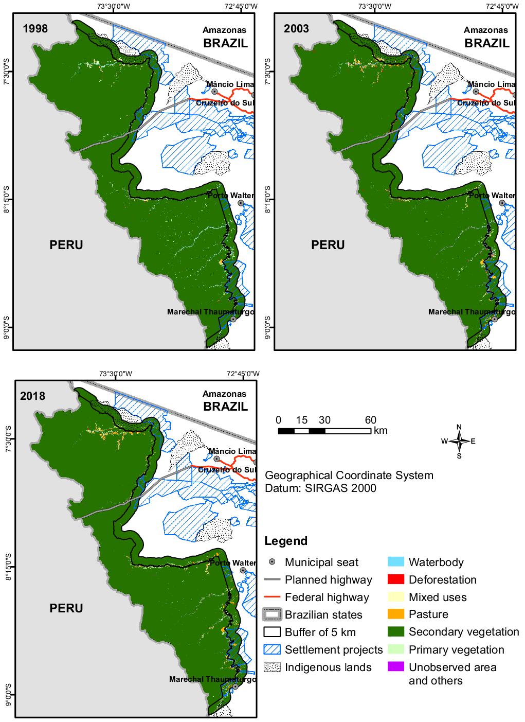
Fig. 2. Land use and land cover in 1988, 2003 and 2018 in and around the Serra do Divisor National Park.
Table 1. Transition matrices of land use and land cover for the years 1988, 2003 and 2018 and the transitions between classes in the periods 1988–2003 and 2003–2018 within the Serra do Divisor National Park.

D = deforestation; MU = mixed uses; O = others; P = pasture; PV = primary vegetation; SV = secondary vegetation; UA = unobserved area; W = waterbodies.
The areas occupied by pasture and deforestation account for 15–17% of the non-forest area, showing the stability of human occupation. The main change in land cover in the SDNP was the transition from PV to SV classes and MU, representing 67–71% of the area without native forest (1447 ha), with 43–45% being SV.
Forest loss within the buffer zone was greater than inside the SDNP (Fig. 2), with the buffer zone experiencing a 10% loss of forest over the 30 years (Table 2). The replacement of PV by the P and D classes represented 22% of the changes in the PV class between 1988 and 2003 and 39% of the changes in the most recent period (2003–2018). The abandonment of agriculture and ranching to SV and subsequent transition to ‘forest’ (secondary forest with a structure similar to that of PV) was 45% during 1988–2003, decreasing to 25% during 2003–2018. The maintenance over time of productive areas (P and MU) was greater in the 5-km buffer zone than in the Park. Areas and percentages of land-use and land-cover classes in 1988, 2003 and 2018 in the SDNP and in the 5-km buffer zone are given in the Supplementary Material (Tables S3 & S4).
Table 2. Transition matrices of land use and land cover for the years 1988, 2003 and 2018 and the transitions between classes in the periods 1988–2003 and 2003–2018 in the buffer zone of the Serra do Divisor National Park.

D = deforestation; MU = mixed uses; O = others; P = pasture; PV = primary vegetation; SV = secondary vegetation; UA = unobserved area; W = waterbodies.
The natural land covers in the SDNP, such as WB along the Juruá and Moa rivers, occupied an average of 1601 ha. The transitions observed between classes O and W for PV and SV in the matrices (Tables 1 & 2) are due to the changes that occurred in the courses of the Juruá, Juruá Mirim, Moa and other rivers because they meander over time. The O class includes areas disturbed by natural landslides in the Jaquirana, Moa, Juruá Mirim and Rio Branco mountains, caused periodically by excessive rain or by earthquakes.
Discussion
Land-use change in and around the Serra do Divisor National Park
Researchers have shown that the establishment of PAs mitigates deforestation in the Amazon (Barber et al. Reference Barber, Cochrane, Souza and Laurance2014, Schleicher et al. Reference Schleicher, Peres, Amano, Llactayo and Leader-Williams2017). Our results reveal that the SDNP has been effective in controlling the expansion of deforestation, as in 30 years the park lost only 1% of its forest cover, in contrast with its immediate surroundings, which lost 10% of their forest cover. Transitions from forest to other uses occurred in settlement projects to the south of the SDNP, such as the Amônia Settlement Project (Fig. 3), consistent with similar situations identified in the state of Pará (Calandino et al. Reference Calandino, Wehrmann and Koblitz2012) and the state of Roraima (Barni et al. Reference Barni, Pereira, Manzi and Barbosa2015). The production of manioc (cassava) flour along with other agricultural crops is related to the expansion of the areas of mixed uses in the SDNP (455 ha in 1988 increasing to 2972 ha in 2018) and in its surroundings (340 ha in 1988 increasing to 5282 ha in 2018). Manioc flour is the most important regional product and is the main source of income for most residents of the study region.

Fig. 3. Changes in land use and land cover between 1988 and 2018 in and around the Serra do Divisor National Park, Marechal Thaumaturgo region.
The consistent monitoring of land-cover and land-use transitions indicates that some administrative territorial designations are more effective at deterring deforestation, associated with inspection and control policies being more effective at reducing deforestation (Hargrave & Kis-Katos Reference Hargrave and Kis-Katos2013). That said, CUs such as national parks have increasingly struggled to protect standing forest under the pro-agribusiness and developmentalist rhetoric and policies of Brazilian President Bolsonaro (Fearnside et al. Reference Fearnside, Ferrante, Yanai and Isaac Júnior2020, Ferrante & Fearnside Reference Fearnside2021). In addition, we recognize that the SDNP’s remoteness, borderland location, lack of roads and mountainous interior may make deforestation more difficult and bias our results (Joppa & Pfaff Reference Joppa and Pfaff2009). Similarly, while navigable rivers provide axes of deforestation in the Amazon, less deforestation takes place within PAs bordering rivers (Barber et al. Reference Barber, Cochrane, Souza and Laurance2014), thus potentially increasing negative spatial spill-over of deforestation on the riverside outside of PAs and other administrative units (Pfaff & Robalino Reference Pfaff and Robalino2017, Pfaff et al. Reference Pfaff, Robalino, Walker, Aldrich, Caldas and Reis2007). This research also does not analyse the potentially important role of crop (e.g., manioc) and livestock (e.g., cattle) prices or changing conservation policies on deforestation within or outside of the Park (Assunção et al. Reference Assunção, Gandour and Rocha2015). However, a new international highway through the SDNP would provide access to and accelerate deforestation in previously remote, borderland and mountainous areas while also likely increasing spill-over via secondary roads and providing opportunities for more price- and policy-induced deforestation along roadsides.
Threats to the Serra do Divisor National Park
The SDNP is considered to have high biodiversity and endemism, as well being a centre for ecotourism (Scarcello & Passos Reference Scarcello and Passos1998). The SDNP is recognized for the wealth of mammal and amphibian species (Bernarde et al. Reference Bernarde, Miranda, Albuquerque and Turci2016) and for its endemic species, such as Thamnophilus divisorius (Whitney et al. Reference Whitney, Oren and Brumfield2004) and various hymenopterans (Azevedo & Batista Reference Azevedo and Batista2002) and lepidopterans (Dolibaina et al. Reference Dolibaina, Dias, Mielke and Casagrande2015). The isolated low mountains of the SDNP and its Peruvian sister park are geologically distinct from most of the Amazon lowlands and provide unique landscapes and habitats in the Brazilian Amazon (Vriesendorp et al. Reference Vriesendorp, Schulenberg, Alverson, Moskovits and Moscoso2006).
Since 2010, discussions have been underway between Brazil and Peru and a protocol of intentions has been signed on the construction of a highway connecting Cruzeiro do Sul (Brazil) and Pucallpa (Peru) (COSIPLAN 2017). This proposal is based on expanding the flow of Brazilian products to international markets through Peru’s Pacific Ocean ports and the flow of Peruvian goods to Brazilian markets. The execution of this infrastructure project poses a great challenge to the central objective of the SDNP. Multiple studies have shown increased anthropogenic pressures after opening roads in or near CUs (Yanai et al. Reference Yanai, Fearnside, Graça and Nogueira2012, Vilela et al. Reference Vilela, Harb, Bruner, Arruda, Ribeiro and Alencar2020, Nascimento et al. Reference Nascimento, Silva, Bordignon, Melo, Brandão, Souza and Silva Junior2021). Walker et al. (Reference Walker, Simmons, Arima, Galvan-Miyoshi, Antunes, Waylen and Irigaray2019) and Lovejoy and Nobre (Reference Lovejoy and Nobre2018) have shown that deforestation associated with such infrastructure could push the Amazon rainforest beyond a ‘tipping point’, causing its collapse in the southern and south-western regions.
Land invasion, real-estate speculation and deforestation quickly escape government control (Ferrante & Fearnside Reference Ferrante and Fearnside2020). Habitat fragmentation, forest fires and excessive hunting, amongst other forms of environmental degradation, have irreversible impacts (Laurance et al. Reference Laurance, Goosem and Laurance2009, Reference Laurance, Clements, Sloan, O’Connell, Mueller and Goosem2014, Harrison Reference Harrison2011). The biodiversity of the SDNP region could be harmed due to fragmentation of the forests with the construction of the road (González-Suárez et al. Reference González-Suárez, Ferreira and Grilo2018). Examples can be found of various highways that pass inside PAs, affecting them both directly and indirectly (Bager et al. Reference Bager, Borghi and Secco2015). The construction of the proposed Cruzeiro do Sul–Pucallpa road can be expected to increase social vulnerability by facilitating the trafficking of drugs, weapons, bushmeat, wild animals and natural resources (Young Reference Young, Steinberg, Hobbs and Mathewson2004, Suárez et al. Reference Suárez, Morales, Cueva, Utreras, Zapata-Ríos and Toral2009). Drug trafficking is consolidated in the region, since Peru is one of the world’s leading producers and exporters of coca derivatives, with the Peruvian department of Ucayali, of which Pucallpa is the capital, being a growing centre of such production, and Brazil is the main destination country in South America for cocaine and a key transit country for drugs headed to Europe and Africa (Santos Reference Santos2010, Salisbury & Fagan Reference Salisbury and Fagan2013). The Isconahua people (an Indigenous group in a state of isolation and initial contact) would be particularly vulnerable to the road and subsequent threats such as disease, exploitation and cultural change (Krokoszynski et al. Reference Krokoszynski, Stoinska-Kairska and Martyniak2007).
The economic benefit used as justification for this highway, which is part of the IOC, is questionable, particularly in view of the existence of the IOS in eastern Acre, which has linked the capital of Acre (Rio Branco) with Pacific ports in Peru since the late 2000s. The IOS has been a disappointing mechanism for legitimate economic growth and produced an ongoing corruption scandal in Peru that has implicated four of the country’s presidents (Alberti & Pereyra Reference Alberti and Pereyra2018, Perz & Rojas Reference Perz and Rojas2020). Indeed, the IOS obviates the argument that the Cruzeiro do Sul–Pucallpa highway is needed for the integration of Brazil’s agricultural heartland with Peruvian ports, especially since the existing route is underutilized (Oliveira et al. Reference Oliveira, Soares-Filho, Costa, Lima, Garcia, Rajão and Carvalho-Ribeiro2019).
Economic cost–benefit estimates for the Cruzeiro do Sul–Pucallpa highway are negative, even without including the social and environmental costs (Glave et al. Reference Glave, Hopkins, Malky and Fleck2012, Hopkins et al. Reference Hopkins, Malky, Glave, Ventocilla, Ledezma and Arana2015). The road project also shows a persistent lack of coordination: the proposed Brazilian route would arrive at the border 25 km north of the proposed Peruvian route (Salisbury et al. Reference Salisbury, Moreno, Torres, Vásquez, Diaz and Tipula2013). The socio-environmental impacts in Acre of the proposed road need to be analysed, including estimating the losses of natural capital and ecosystem services, and potential mitigation needs to be assessed, as was done for impacts in the department of Ucayali, Peru (Mandle et al. Reference Mandle, Tallis, Vogl, Wolny, Touval and Sotomayor2013). The costs also need to be compared to alternative proposals for regional development. Measures that can reduce social and environmental costs in the face of climate change and its long-term impacts include payment for forest ecosystem services, landscape restoration and the adoption of environmentally sound agricultural practices (Lapola et al. Reference Lapola, Pinho, Quesada, Strassburg, Rammig and Kruijt2018).
Due to the ‘full protection’ category of the SDNP in Brazil’s National System of Conservation Units (SNUC), approval of the road has faced barriers due to the need to follow strict rules under Brazilian law. This protection status is threatened by the proposed downgrading to an APA (Bill 6024/2019). Some interest groups in Brazilian society claim that the social and environmental gains generated by fully protected CUs in the Amazon region restrict local economic growth, a claim that has been contested by Kauano et al. (Reference Kauano, Silva, Diniz Filho and Michalski2020).
Downgrading, downsizing and degazetting PAs are occurring worldwide and especially in Brazil (Mascia & Pailler Reference Mascia and Pailler2011, Pack et al. Reference Pack, Ferreira, Krithivasan, Murrow, Bernard and Mascia2016). Currently threatened PAs in Brazil include the Nascentes do Lago Jari National Park on Highway BR-319 (Manaus–Porto Velho), through which a road (AM-366) is planned (Fearnside et al. Reference Fearnside, Ferrante, Yanai and Isaac Júnior2020), the Jamanxim National Forest on Highway BR-163 (Santarém–Cuiabá), through which a planned railway would pass (Chagas Reference Chagas2017), and the Iguaçu National Park that protects the largest remaining fragment of inland Atlantic rainforest, though which the proposed ‘Caminho do Colono’ road would pass (Prasniewski et al. Reference Prasniewski, Szinwelski, Sobral-Souza, Kuczach, Brocardo, Sperber and Fearnside2020).
Motivations for downgrading PAs vary widely, but they invariably focus on access to and use of natural resources (Mascia & Pailler Reference Mascia and Pailler2011) and may be related to the size of the PAs and local population densities (Symes et al. Reference Symes, Rao, Mascia and Carrasco2016). Re-categorization, disaffection or reduction of the limits of PAs can result in dramatically higher deforestation rates and forest carbon emissions (Forrest et al. Reference Forrest, Mascia, Pailler, Abidin, Araujo, Krithivasan and Riveros2015). Prior to re-categorization it is essential to carry out technical studies and public consultation on such measures (Zamadei et al. Reference Zamadei, Heimann and Pires2019). Such studies also must account for the SDNP’s location and role in a transboundary conservation corridor that stretches from the Amazon River to the Madre de Dios River (Vriesendorp et al. Reference Vriesendorp, Schulenberg, Alverson, Moskovits and Moscoso2006, Grupo Geográfico Transfronterizo de la Amazonía Sud Occidental 2013).
Implications for conservation
The SDNP still conserves c. 98% of its primary forest, and 48% of the total that was deforested by 2018 now has secondary vegetation. Forests in PAs store and capture atmospheric carbon, and their preservation could be an important contributor to mitigating global warming (Maxwell et al. Reference Maxwell, Evans, Watson, Morel, Grantham and Duncan2019). As of 2014, the SDNP’s forests held 134.9 million Mg of carbon (above and below ground), having lost only 2% of its original stock to deforestation since c. 1970 (Nogueira et al. Reference Nogueira, Yanai, Vasconcelos, Graça and Fearnside2018).
The preservation of the SDNP contributes to the food security of the inhabitants of the PA through the protein coming from wild animals (Sarti et al. Reference Sarti, Adams, Morsello, van Vliet, Schor and Yagüe2015, Lemos et al. Reference Lemos, Bizri, Amaral, Santos, Koga and Silva2018). There are 407 families in the SDNP that use natural resources and engage in small-scale agriculture and livestock raising, in addition to the people who visit for tourism and for scientific or educational purposes. Increased involvement of the local population should be sought in the decision-making processes in PAs because this is a prerequisite for both conservation and socioeconomic development (Oldekop et al. Reference Oldekop, Holmes, Harris and Evans2016).
The south-western part of the Amazon basin, in which the SDNP is located, is an important direct and intermediate source of moisture distributed to the Prata basin that includes São Paulo and Buenos Aires (Zemp et al. Reference Zemp, Schleussner, Barbosa, van der Ent, Donges and Heinke2014). Changes in land use in this region of the Amazon can weaken the forests’ water recycling role, modifying precipitation thousands of kilometres from this location and intensifying climatic extremes, thus affecting agricultural productivity both inside and outside of the tropics (Lawrence & Vandecar Reference Lawrence and Vandecar2015).
These impacts are in addition to the scenario investigated by Leite-Filho et al. (Reference Leite-Filho, Costa and Fu2020), who found that a shortening of the rainy season has occurred in southern Amazonia over a period of 15 years due to deforestation and other factors. The dry season has already lengthened in southern Amazonia (Espinoza et al. Reference Espinoza, Ronchail, Marengo and Segura2019). Both of these analyses could be applied to the SDNP region and its surroundings in a future study.
Conclusions
That the SDNP underwent much less reduction in primary forest (1%) over the 30-year period from 1988 to 2018 than did a 5-km buffer zone in the surrounding area (10%) demonstrates the importance of PAs in the Amazon region and reaffirms the roles that these areas play in maintaining forest and thus mitigating climate change and protecting biodiversity. A proposed downgrading of this national park to an APA would impact the >400 families that live in the Park, as would a proposed road that would bisect the Park. Studies show the economic infeasibility of the road project and the likely impacts on deforestation, biodiversity and the regional and continental climate regime. Stopping both the proposed road project and the downgrading of the Park’s protected status would be the most appropriate way to maintain the forest in the Park and to contribute to regional and global climate stability.
Supplementary material
To view supplementary material for this article, please visit https://doi.org/10.1017/S0376892922000091.
Acknowledgements
None.
Financial support
Some of the researchers were supported by the Ministério da Ciência, Tecnologia e Inovação/Conselho Nacional de Desenvolvimento Científico e Tecnológico (grant numbers 311103/2015-4, 442650/2018-3), FINEP/Rede CLIMA (grant number 01.13.0353-00) and Ministério da Ciência, Tecnologia e Inovação/Instituto Nacional de Pesquisas da Amazônia (grant number PRJ15.125).
Conflict of interest
The authors declare none.
Ethical standards
None.


 Open access