

I. Research on snow cover in China
China is one of the countries where snow cover is extensively distributed at middle and low latitudes. The snow cover in China belong to two categories, permanent snow cover and seasonal snow cover. The former is distributed above snow line in the regions of high mountain and plateau in west China. It coincides with the glacier region. The latter is generally distributed in the vast regions north of lat. 25°N. North-east China and northern part of Sinkiang Uighur Tzu-chih-ch'ü (Xinjiang Uygur Zizhiqu) are the seasonal snow cover regions of maximum thickness.
We put stress on the following three subjects in our researches on snow cover in China.
1. Snow-cover geography and its significance in the productivity of agriculture and livestock breeding
In recent years we have made comparatively extensive researches on the time and space distribution of snow cover in China, regional properties, climatic division of snow cover and its significance in the productivity of agriculture and livestock breeding. We have realized that snow cover is an important water resource and plays a role of preserving heat and moisture in the top soil in winter. It is of great significance in the nourishment of river flows.
2. Anti-avalanche and snow-drift research
Snow-drift and avalanche damage caused by seasonal snow cover often occurs in winter and spring in north-east and north-west China and on Ch'ing-hai Tibetan Plateau (Qinghai Xizang Gaoyuan). They cause serious disruption of communication and transportation, the construction of factories and mines, and the production of agriculture and livestock breeding. Since 1967, Lanchou Institute of Glaciology and Cryopedology, Academia Sinica, and other state organs have organized avalanche and snow-drift protection in T'ien-shan. Since then we have conducted experimental research on snow in motion—snow-drifts and avalanches. According to our observations, stationary measurements, and experiments with wind-tunnel simulation tests of snow-drifts, we have got to know part of the systematic formation and development of snow-drifts. In the course of our field work for protection from snow-drift, we have found out some effective methods of protection. In addition, we have surveyed, though still at an initial stage, the distribution and occurrence of avalanches in T'ien-shan. By making engineering experiments we have offered proposals for preventing avalanches. Effects have been shown to a certain extent.
3. Research on physical and mechanical properties of snow cover
At present, in our programme for the prevention of avalanches, our researches on physical and mechanical properties of snow cover are mainly concentrated on the density of snow, snow-crystal change, the temperature of snow cover, the metamorphism of snow, the friction properties of snow, and the determination of the mechanical properties of snow cover, such as its hardness, compressive strength, tensile strength, shear strength, fracture strength, and so on. All these have to a certain extent filled the blanks in the research on snow cover in China. But we have not yet carried on our researches to the thermal, electrical, acoustical, and optical properties of snow.
II. The avalanche phenomena of Batura Glacier in Pakistan
The Karakoram Highway, built jointly by China and Pakistan, crosses the Batura Glacier terminus on the right bank of the Hunza River. The 1973 flood damaged the highway and the bridge over the Batura channel. In order to propose a reasonable reconstruction project, the government of the Islamic Republic of Pakistan and the People's Republic of China agreed that a research group of Chinese scientists be sent to Batura Glacier. The group made investigations in the Batura Glacier region from April 1974 to November 1975, and May to December 1978. During the expedition, we found some very interesting phenomena on the avalanches and ogives of the glacier.
Batura Glacier, with a length of 59.2 km, has a total area of 285 km2. The snow line in the drainage basin ranges from 4 700 to 5 300 m a.s.l. The accumulation area above the snow line reaches a total of 144 km2. The snow-fall is abundant. By measuring the ice thickness of the annual layers in the firn basin and the annual discharge of the melt water of the glacier, we roughly estimated that annual precipitation above the snow line may be over 2 000 mm. Owing to such abundant precipitation, together with high and steep slopes of the Hunza Karakoram on the southern side of Batura Glacier, avalanches occur frequently, and become the main source of nourishment of the glacier. As Visser writes (Reference Visser and Visser-HooftVisser and Visser-Hooft, 1938):
“Nowhere else have I heard such uninterrupted avalanches thunder as in this part of the Karakoram. This incessant roar provides the solution of the problem of how this long valley with its small névé fields gets its fodder. We saw a further solution in the enormous blocks of ice and snow lying heaped up on the glacier, and also the indented tracks of dust avalanches which were everywhere visible on the ice-armoured walls.”
When we came to Camp VI which was established on the glacier at 4 500 m a.s.l. at 11 p.m. on the night of 9 August 1974, a large avalanche from Hunza Karakoram occurred. The thunderous noise came suddenly. The door-screens of the tents were opened by the air pressure wave of the avalanche. The powerful dust cloud followed for twelve minutes successively. The vertical displacement of this avalanche was about 2 500 m. The magnitude of the avalanche deposits was estimated at 30 000 m3.
The avalanches of Batura Muztagh are quite representative. They are of frequent occurrence.
Our Camp III was established on the edge of Batura Glacier opposite the Muztagh, the highest peak of Hunza Karakoram (7 795 m a.s.l.). It provided the best opportunity for studying the avalanches of the Muztagh. Mr Bai Zhongyuan,* a member of our group, carried out eight days of observations. In addition we made investigations from helicopter and adventurously reached the lower parts of the avalanche path for surveying and studying. The brief results are as follows:
1. Distribution and probability of the avalanches of the Batura Muztagh
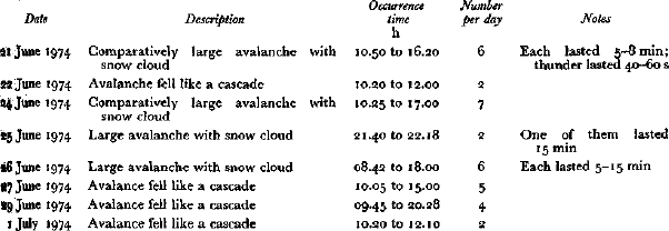
The source of avalanches is distributed on the ridges stretching south-east and north-west from the Muztagh peak. These ridges are in serrated form. Most slopes are very steep but that from the peak down the Batura first ice fall is relatively moderate. Snow attaches to the ridges and precipitous slopes, and once it is out of balance, avalanches would occur and nourish the glacier. It is a basic material condition of glacier. As the avalanche nourishment is unequal from year to year, the velocity of the glacier movement and the width of the ogives are also unequal. Because of topographic difficulties the avalanche region is inaccessible. Mr Bai merely took observations from a far distance and got the data in Table I. Table I shows examples of some avalanches of the Batura Muztagh. The avalanches, which were clearly viewed from 3 to 4 km away, were comparatively large, and such large avalanches were found to happen four times a day. As to the time of occurrence, they were generally in the afternoon, and more often happened when the weather suddenly turned fine right after a snow fall.
Table I. Statistical table of the avalanches of the Batura Muztagh firn basin
2. The damage from the avalanches of the Batura Muztagh
In 1959, Dr Keith Warburton, the leader of the Batura Muztagh Expedition whose main objects were a mountaineering reconnaissance of the Batura Muztagh, and his four companions unfortunately lost their lives while climbing.
Dr Warburton set out with four of the party, two Englishmen and two Germans, on 23 June to climb the Batura Muztagh. On about 28 June a Pasu native hunter on the Fatimahal had watched with his binoculars as two figures climbed steadily on a shoulder which lies about 450 m below the summit at 7 795 m a.s.l. From 2 to 5 July it rained and snowed heavily at Base Camp. So much precipitation happened only once in 50 years. It was speculated that Dr Warburton's expedition was then probably working on the highest peak of the Batura Muztagh summit, and later, though search parties were sent out, no trace of the five of their camp was found. It must be assumed that Dr Warburton with his four companion buried by snow and avalanches.
In July 1975, the Batura Glacier Investigation Group of China found remains Warburton's expedition at a place 3 500 m a.s.l., such as a climbing shoe, a book, a har some nails for tents, etc. In July 1978 more remains were found, again on the glacier 3 480 m a.s.l. This time a hat, a climbing shoe, clothes, glasses, a camera, an exposure 1 purses, matches, and many cans were found. As for glasses, hat, camera and underwears were carried by their owners on the summit. From this evidence, it is believed that the men of Dr Warburton's expedition met their death here and were buried by the avaliable.
3. Estimation of avalanche transportation process from the Warburton remains
Dr Warburton's remains supply information for estimating the transportational pro-avalanches.
We supposed that Dr Warburton with his four companions died at a place about 7 a.s.l. Judging from the fact that there is no steep slope in this section, that during our there no large avalanche occurred, and that the book and some other remains were good order, we assumed that probably the distance of movement and the difference of of that avalanche is small.
The remains of Dr Warburton were first found in 1975, on the ninth ogive at 3 500 m a.s.l. the other remains were found later in 1978, on the twelfth ogive at 3 480 m a.s.l. By condition, comparison, and repeated photographing it is proved that one ogive is formed in (Figs 1 to 5).
From Figure 1 we know that ogives were pushed by new formations, the width so between two successive ogives along the axis. But there is no definite ratio among them width of ogives may represent to a certain degree the yearly accumulation of snow.
From Figure 1 we suggest, that in the year 1959, snow-fall was abundant in Muztagh and avalanches occurred more frequently than in 1974. From a Sabina sample at a place 3 800 m a.s.l, on Batura Glacier, its ring for the year 1959 is compare to narrower than those in the year before and after. Reference EdwardsJ. I. Edwards (1960) reported that the end of June to early July, when Dr Warburton was climbing the summit, avalanches occurred five or six times every day. This can be compared with 1974 in which the daily occurrence of avalanches was only four times a day. Thus from the variation of the width of ogives we have some information on the yearly changes of snow-fall in the past.
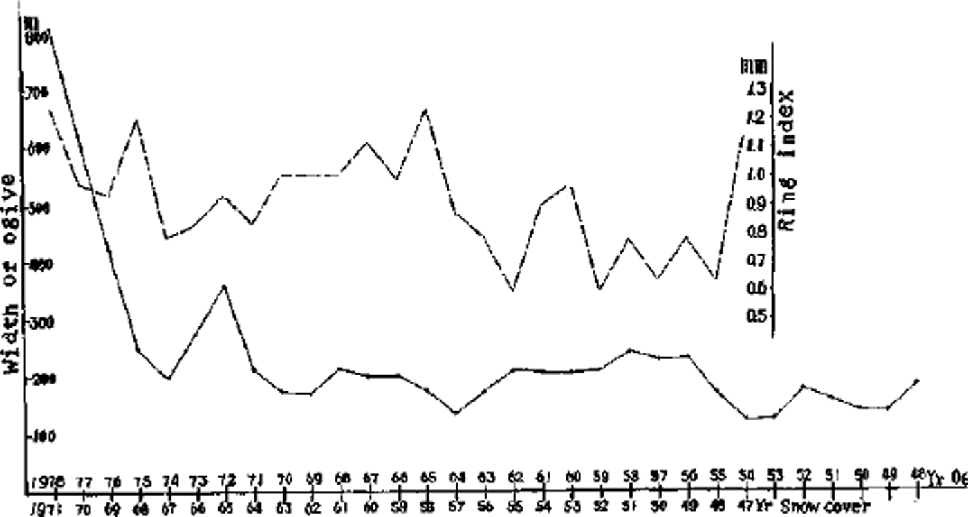
Fig. 1. Relation between width of ogive, snow cover, and tree-ring index.
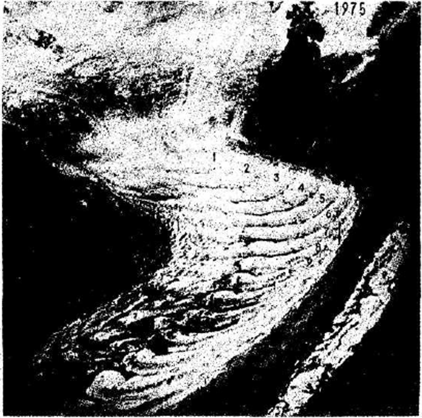
Fig. 2. The ogives of Batura Glacier, photograph from helicopter, 31 August 1975.
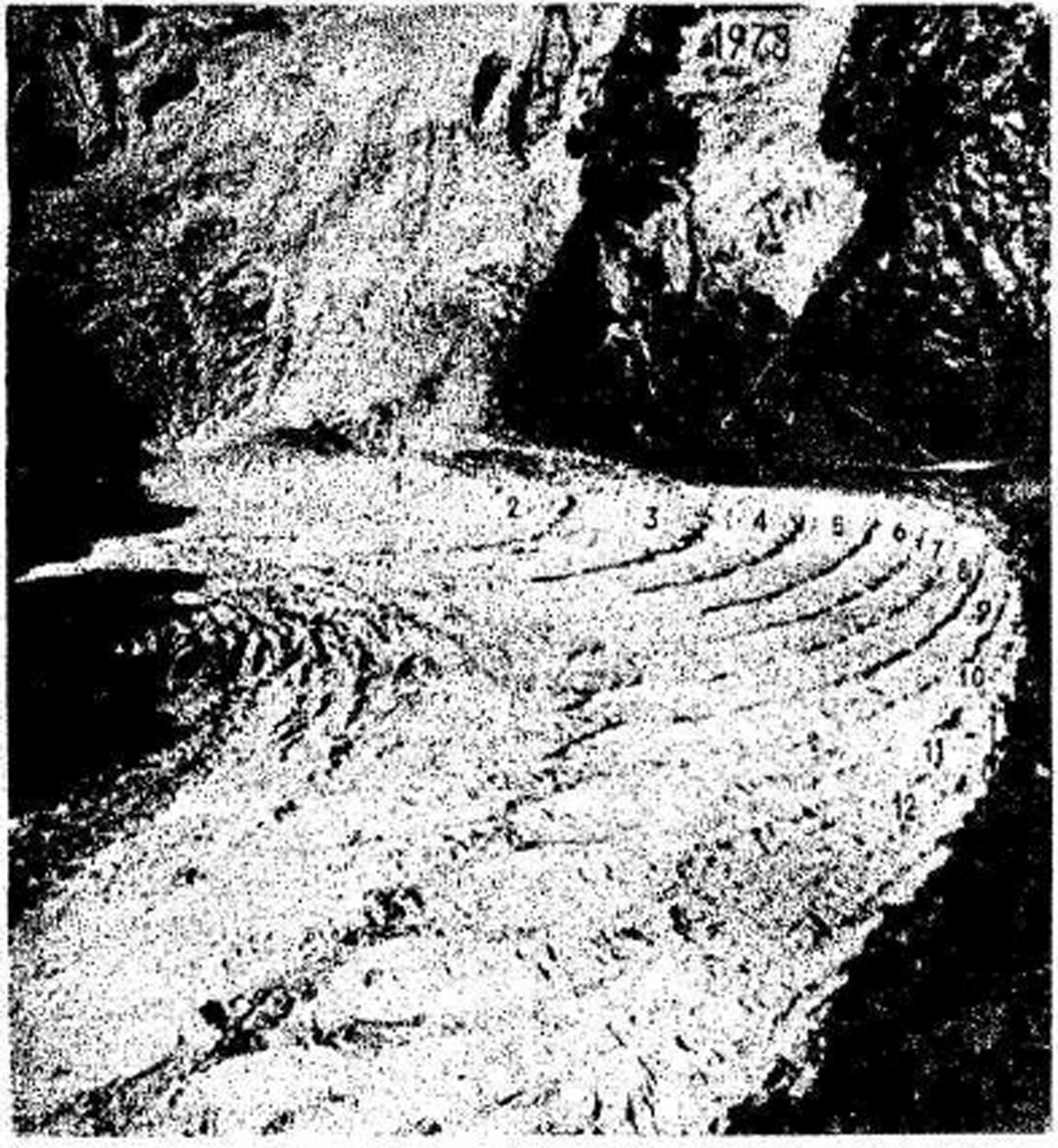
Fig. 3. The ogives of Batura Glacier, photograph from helicopter, 1 November 1978.
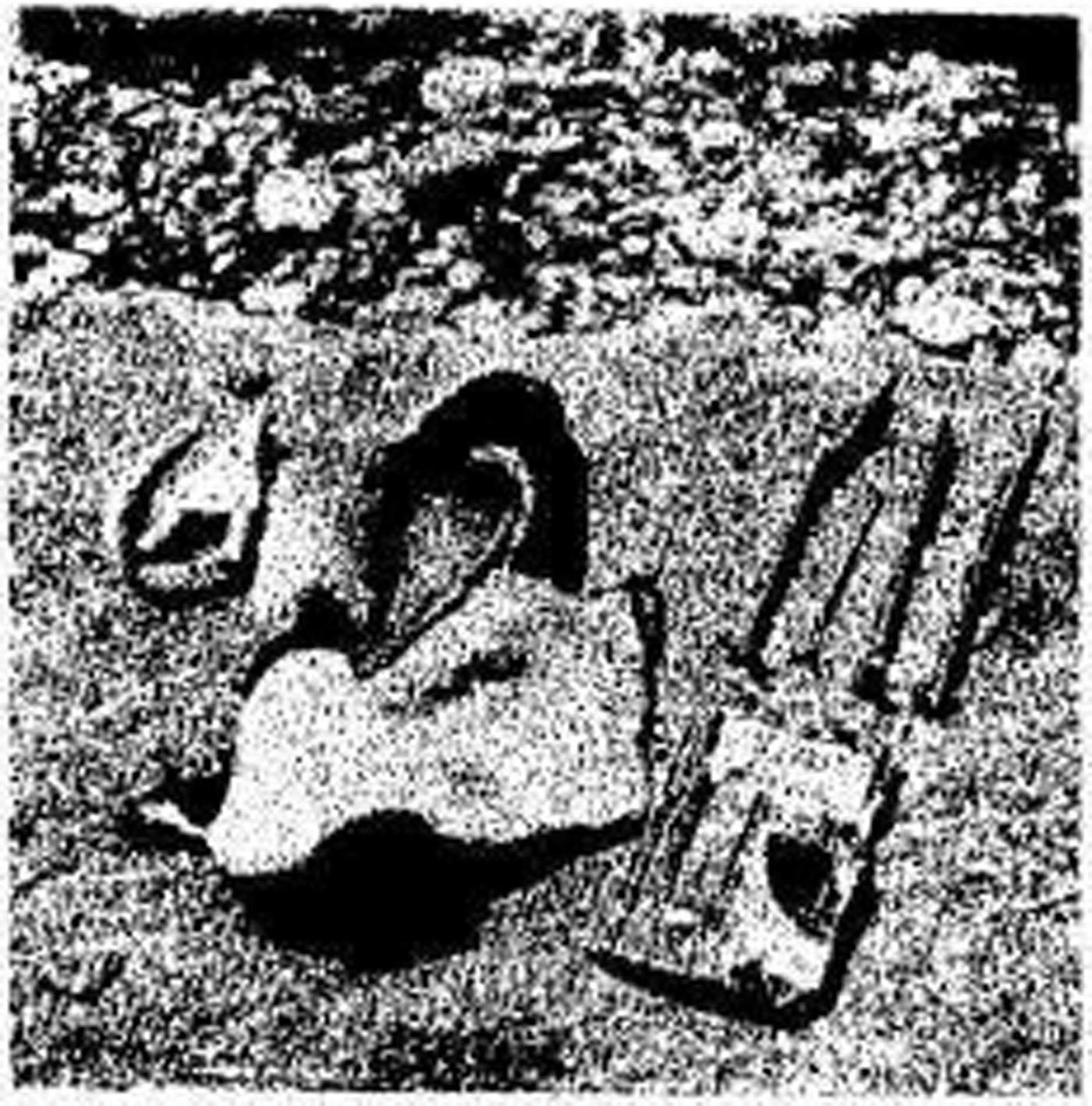
Fig. 4. The remains of Dr Warburton found in 1975.
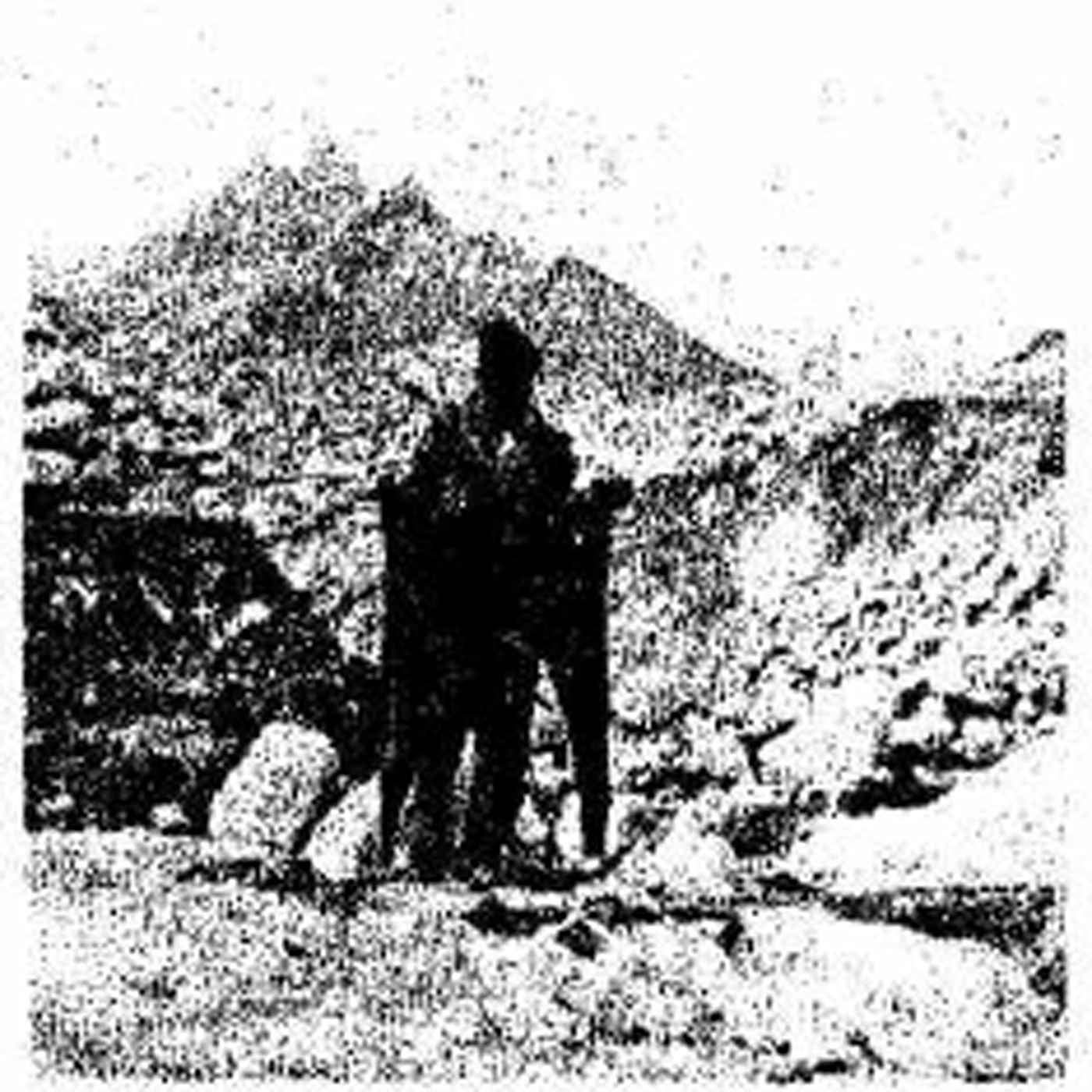
Fig. 5. The remains of Dr Warburton found in 1978.
The horizontal distance from the place at about 7 000 m a.s.l. below the Batura Muztagh summit to the last ogive is about 7 km. The time required to transport the snow and ice from the place of their death to the foot of the Batura Muztagh can be estimated from Dr Warburton's remains. They died in 1959 and up to 1978 nineteen years had elapsed. Their remains were found on the twelfth ogive. This means that it took about seven years for the remains to cover a horizontal distance of 7 000 m, i.e. about 1000 m/year. In summer 1978, at the survey point that lies in the middle reach between the summit and the last ogive, we found the velocity of the glacier to be 1 245.3 m/year. The motion velocity in the ice fall measured by J. I. Edwards was about 1300 m/year. These two values are very close. It is generally accepted that the breaking of ice to the surface represents the change in velocity. The velocity in the ice-fall area is faster than the mean velocity from Muztagh summit to the last ogive by about 30%.
Avalanches occur frequently on the south-east slope of the Batura Muztagh, their maximum vertical displacement reaches about 3 000 to 3 500 m, and the lowest topographical snow line lies at 4 000 m a.s.l. in this region.


