


Introduction
From later prehistory to the present day, land divisions (field systems, boundaries, trackways, and enclosures) are ubiquitous features of the British countryside, providing evidence for cultivation, animal husbandry, political power, and social identity. Land divisions are remarkably common, with around seventy per cent of the English landscape currently organized within field systems (McOmish, Reference McOmish2011). Even the highest and most remote landscapes have been divided into parcels, while lower-lying regions are shaped by deep histories of enclosure and agricultural transformation (Figure 1). This makes England, and Britain and Ireland more broadly, an important region in which to observe and understand the relations between land enclosure, agriculture, and society from a long-term perspective.
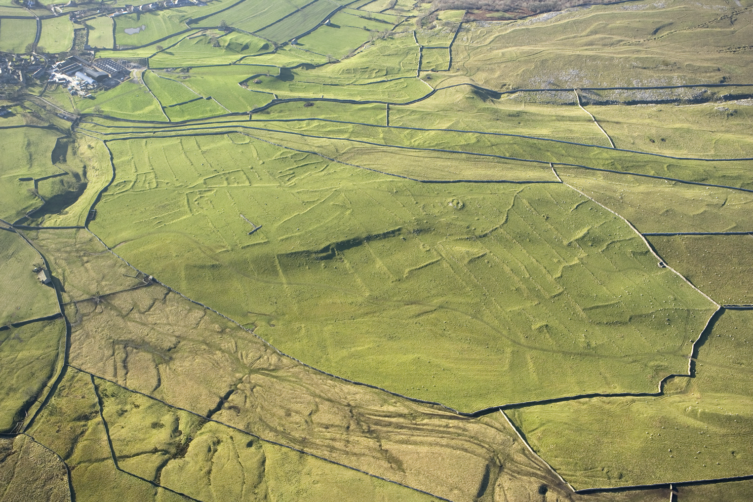
Figure 1. Earthworks of Iron Age/Romano-British field systems and enclosures at High Close, Grassington, North Yorkshire. The term coaxial fields refers to their adherence to a dominant alignment, often north-east to south-west, or north–south. The Grassington fields are associated with a range of other monuments including cairns, trackways, and enclosure compounds. © Historic England Archive, 20845_050 25-NOV-2008.
The time-depth of these preserved land divisions has been long recognized. Eighteenth- and nineteenth-century antiquarians, such as William Stukeley and Richard Colt Hoare, first identified later ‘prehistoric’ field systems (Johnston, Reference Johnston, Fokkens and Harding2013), while Philip Crocker's survey for Colt Hoare at Stockton, Wiltshire, identified Romano-British settlement overlying earlier field boundaries (Hoare, Reference Hoare1810: 39). In the early twentieth century, O.G.S. Crawford and the Curwens described the character of ‘prehistoric’ field systems (Crawford, Reference Crawford1923; Curwen & Curwen, Reference Curwen and Curwen1923), and Toms (Reference Toms1925) speculated that the field systems in Cranborne Chase, Dorset, dated to the Bronze Age or earlier. Around the same time, there was a growing interest in medieval field systems, especially open fields (Gray, Reference Gray1915).
Subsequent archaeological work has refined our knowledge of the extent and character of land divisions of all ages (e.g. Bradley, Reference Bradley1977; Fleming, Reference Fleming1988; Yates, Reference Yates2007; Oosthuizen, Reference Oosthuizen2013; Rippon et al., Reference Rippon, Smart and Pears2015; Ten Harkel et al., Reference Ten Harkel, Franconi and Gosden2017). Yet, despite their common occurrence and importance, the timing and tempo of their emergence and expansion is poorly understood. Attempts at synthesis between regions are hampered by the absence of robust scientific chronologies. For example, in southern England, Field (Reference Field and Pollard2008) suggested two major events of land division in later ‘prehistory’, while noting the need for an independent chronological framework. These are: the emergence of ‘Celtic’ and coaxial field systems in the mid-second millennium cal bc, and the layout of larger, ranch-like land units in the first millennium cal bc.
The earliest examples of land divisions currently known in Britain date to the Early Bronze Age (e.g. Martin et al., Reference Martin, Schuster and Barclay2012), while more appear later in the second millennium cal bc (e.g. Framework Archaeology, 2011). In some areas, the establishment of new field systems probably declined in the Iron Age (e.g. Lambrick & Robinson, Reference Lambrick and Robinson2009: 80 ff; Sharples, Reference Sharples2010: 43) while different types of boundaries, such as linear earthworks and pit alignments, emerged (e.g. Bradley et al., Reference Bradley, Entwistle and Raymond1994; Rylatt & Bevan, Reference Rylatt, Bevan, Haselgrove and Moore2007). Field systems were established in many areas in the Romano-British period (e.g. Garton et al., Reference Garton, Lear, Cowgill, Firman and Wright2008) and had a variable impact on the shape of later, medieval landscapes (Rippon et al., Reference Rippon, Smart and Pears2015), which themselves evolved over time (e.g. Oosthuizen, Reference Oosthuizen2013).
While the economic importance of field systems is obvious, they do more than enclose resources; they reflect aspects of social organization, including degrees of social stratification, control over people and animals, and ideas about ownership, belonging, and identity. Variation between regions may also suggest different trajectories of change; but the absence of independent chronologies severely limits our interpretations (see Løvschal, Reference Løvschal2014).
Here, we address this lacuna by using the data acquired through development-led archaeology (some eighty per cent of scientific dates from sites in England), along with data from published sources, to produce the first robust chronology for land division features from a region of Britain. We have chosen Yorkshire and the north-east Midlands (Figure 2), areas with well-preserved land divisions from various periods but with a specific regional character and historical trajectory that is distinct from better known parts of Britain such as southern England.

Figure 2. Historic Environment Record (England) regions included in this study, showing the locations of sites with scientific dates discussed.
The Study Region
Evidence from across Yorkshire and the north-east Midlands shows a wealth of types of land divisions that are thought (on the basis of relative typo-chronologies) to date from the Bronze Age onwards. In the north-east Midlands, Bronze Age field systems have been identified in both upland and lowland contexts, for example in the Lower Welland valley in Lincolnshire and on the East Moors in Derbyshire (Willis, Reference Willis and Cooper2006: 94–5). By contrast, the main period of field system creation in Yorkshire appears to be the Iron Age, though linear earthwork land divisions on the Wolds were in use by the end of the second millennium cal bc (Manby et al., Reference Manby, King, Vyner, Manby, Moorhouse and Ottaway2003; Mackey & Manby, Reference Mackey, Manby, Manby, Moorhouse and Ottaway2003). The so-called embanked ‘Celtic field’ systems, for example at Craven in North Yorkshire (King, Reference King, Spratt and Burgess1985), have no satisfactory chronologies. They are often suggested to have been established in the Iron Age but could equally have resulted from Bronze Age activity (Manby et al., Reference Manby, King, Vyner, Manby, Moorhouse and Ottaway2003: 103).
In some parts of the study area, the appearance of enclosed field systems seems to be a later development, spanning the Late Iron Age and Early Romano-British periods; this includes the distinctive ‘brickwork plan’ coaxial systems found by aerial photography on the Sherwood Sandstones of northern Nottinghamshire and South Yorkshire (Willis, Reference Willis and Cooper2006: 113; Garton et al., Reference Garton, Lear, Cowgill, Firman and Wright2008; Figure 3). Aerial mapping has also provided good, if fragmentary, information about the general layout and extent of field systems for the Iron Age and Romano-British periods of the Lincolnshire Wolds and the valleys of the Trent and Welland (Willis, Reference Willis and Cooper2006: 145). Field systems assumed to be of Iron Age or Romano-British date are also known in the Yorkshire Dales (Horne & MacLeod, Reference Horne and MacLeod1995).

Figure 3. Cropmarks of Iron Age/Romano-British coaxial fields north of Harworth, South Yorkshire, and inset showing the general location of Harworth. Base map and data from OpenStreetMap and OpenStreetMap Foundation. Aerial mapping © Historic England. Basemap © Crown Copyright and database right 2021. All rights reserved. Ordnance Survey Licence number 100019088.
Later ‘prehistoric’ linear ditch systems are numerous in parts of the study region, including south-west Lincolnshire, where a band of multiple-ditched linear boundaries cross the Jurassic Limestone Ridge (Willis, Reference Willis and Cooper2006: 123). However, there are relatively few Romano-British and post-Roman earthworks within the north-east Midlands, the Grey Ditch in Derbyshire is the clearest example (Guilbert & Taylor, Reference Guilbert and Taylor1992). The Yorkshire Wolds dyke systems appear to have had a long history of development from the Late Bronze Age to the Late Iron Age or beyond (Dent, Reference Dent1984; Giles, Reference Giles2012), without major disruption to the landscape organisation. Pit alignments are also found on the Yorkshire Wolds as cropmarks; the associated banks survive in places on the North York Moors, for example on the Tabular Hills (Spratt, Reference Spratt1988). When these features are excavated, they usually appear to be associated with ‘prehistoric’ activity, though Romano-British examples are also known.
In the medieval period, most of the region was part of the ‘Central Province’ as defined by Roberts and Wrathmell (Reference Roberts and Wrathmell2002). This was a broad sweep of land extending from Dorset on the south coast to the north and east, encompassing the area east of the Pennines. Much of the landscape here is known as a ‘champion landscape’, with arable land organized into open fields divided into strips and cropped under a two- or three-year rotation. Once extensively covered with ridge-and-furrow, much of the medieval landscape has been destroyed by modern cultivation, though parts of the north-east Midlands retain well-preserved areas of ridge-and-furrow field systems, including areas of Lincolnshire.
The field systems of ‘non-champion’ regions—such as the Lincolnshire fenland, northern and western Derbyshire, Nottinghamshire, and the Pennines—tend to be less regular and were organized in a variety of ways; these regions have generally been little studied (Lewis, Reference Lewis and Cooper2006: 207). An exception is the Yorkshire Dales, where the well-preserved field systems associated with medieval townships have revealed many phases of development from the seventh to the seventeenth century ad (Moorhouse, Reference Moorhouse, Manby, Moorhouse and Ottaway2003).
Project Approach
Our aim was to examine changes in practices of land division across traditional culture historical divisions in this region, in particular changes in the scale and rate of land division over the very long term. We were interested in what a study at this scale might indicate in terms of the social contexts in which these changes took place. We collected scientific dating evidence associated with a wide range of land division types: aggregated field systems, coaxial field systems, enclosures, settlement enclosures, stock enclosures, field boundaries, boundary ditches, ditches, dykes, pit alignments, linear earthworks, and trackways or droveways (Figures 1 and 3; Supplementary Material Figures S2–S10 and Supplementary Material Table S1 for land division definitions). Several of these feature types are not classic ‘field systems’, but we selected a broad sample to examine land division in the widest sense.
Building robust chronologies for land division presents several distinct challenges. The first hurdle is semantic: when does a ‘ditch’ become a ‘field boundary’ (see Chadwick, Reference Chadwick and Chadwick2008), especially when identified in a narrow evaluation trench? For this study we chose to rely on the terminologies used in the excavation reports.
Establishing a robust scientific chronology for land division is by no means straightforward. Samples for radiocarbon dating from land divisions rarely come from clearly understood ‘archaeological events of interest’, and infrequently represent in situ activities, Gwithian in Cornwall is one of a few known exceptions in Britain (Nowakowski, Reference Nowakowski, Allen, Sharples and O'Connor2009). We can think about the ‘archaeological event of interest’ as some form of distinct anthropogenic activity. It could be, for example, the point in time when a field system is first excavated, or the system deconstructed. However, any samples for radiocarbon measurements from this feature may not be well-associated with the excavation of the field system (see discussion below). Land divisions are often negative features in which materials suitable for radiocarbon measurement can accumulate. However, this accumulation can result from a variety of complex processes (for example, manuring using midden deposits), and features may fill and be recut over long periods (Johnston, Reference Johnston2005). Samples from such features have the potential to be residual. For example, the Bronze Age field systems at Fengate, Peterborough, Cambridgeshire, were originally dated to the Late Neolithic because their fills contained Grooved Ware pottery. The pottery had been redeposited in the field ditches when their digging disturbed earlier features (Evans, Reference Evans2009). Producing robust estimates for the establishment of land divisions is, therefore, challenging. In many cases, while ecofacts from within land divisions may not directly relate to the establishment or decommissioning of a boundary, such material may provide estimates for a boundary's active use in a landscape.
In the examples identified in our study, there are no chronometrically dated samples that have a clear functional relationship (Waterbolk, Reference Waterbolk1971) with the establishment of these features. This may partly be due to the underlying geology of parts of our study area, which affects bone preservation in some cases. It may also reflect past activities associated with land division, as opposed to the more frequent occurrence of placed deposits in more obviously ‘monumental’ structures or settlements.
To address these issues, we applied two analytical approaches: one uses site-specific Bayesian analysis of scientific dates, and then ‘currency models’ to explore the timing and tempo of types of land division (see Supplementary Material for discussion). The other looks at long-term patterns in the scale and frequency of all forms of land division over some 3000 years. Our approach was designed to look in a granular fashion at the temporal ‘currency’ of different types of land division, but also to shift perspective and examine the long-term trends in all the evidence available. This dual approach makes it possible to think about complex and difficult datasets in different ways.
Methods
The data collection methods, modelling choices, and results are comprehensively discussed in the Supplementary Material, which also provides full references for the individual sites and every chronometric measurement used in our analysis. The reporting follows criteria outlined in Bayliss (Reference Bayliss2015). As with any ‘legacy data’ project, there are strengths and challenges when dealing with such an inheritance.
Bayesian chronological modelling was undertaken using the program OxCal v4.3 (Bronk Ramsey, Reference Bronk Ramsey2009) and the calibration dataset of Reimer et al. (Reference Reimer, Bard, Bayliss, Beck, Blackwell and Bronk Ramsey2013). The chronological models for each site are described (see Supplementary Material) and defined exactly in the figures and the OxCal code (Supplementary Material). In the text and tables, the Highest Posterior Density intervals of the posterior density estimates are given in italics, followed by a reference to the relevant parameter name and the figure in which the estimate is defined. Our other approach to long-term trends is afforded by Kernel Density Estimation (KDE; Bronk Ramsey, Reference Bronk Ramsey2017), a widely used non-parametric method for estimating underlying distributions of discrete data points (here, dated samples). The number of samples selected for radiocarbon measurements will affect these KDE distributions; for example, if fewer measurements were commissioned from boundaries containing Romano-British material culture, this part of the KDE plot will be lower. This analysis does, however, allow us to take the long view of the available evidence for land division as a whole across different feature ‘types’, and traditional culture historic or period divisions.
Results
The number of active likelihoods (radiocarbon dates and posterior density estimates) and sites represented in the currency models for each type of land division is shown in Figure 4. By far the most frequent feature type from which chronometric measurements are produced are discrete enclosures; this may reflect their relative frequency over time, but also that they are more likely to be positively identified as ‘sites’ and subject to more chronometric measurements than simple linear features.

Figure 4. The number of active likelihoods used in the currency model for different types of feature (in red), and the number of sites with active likelihoods (in blue).
Figure 5 shows a summary of the model for land division (see Supplementary Material) and a timetable for the appearance of different feature types. Overall, land division began in 1815–1490 cal bc (95% probability; Start_Start_Dividing_the_Land; Figure 5), but the timescale of the beginnings of land division was very drawn out, spanning 785–1280 years (95% probability; distribution not shown). In our region, there was a very slow uptake in practices of enclosing and dividing the land. Key estimates for the beginning of use for each class of land division are summarized in Table 1 and Figure 6. Aggregated field systems were the first class of land division to appear in the second quarter of the second millennium cal bc, followed by features identified by excavators as individual ditches (which could, of course, be parts of field systems) and then enclosures (discrete features not part of a field system).
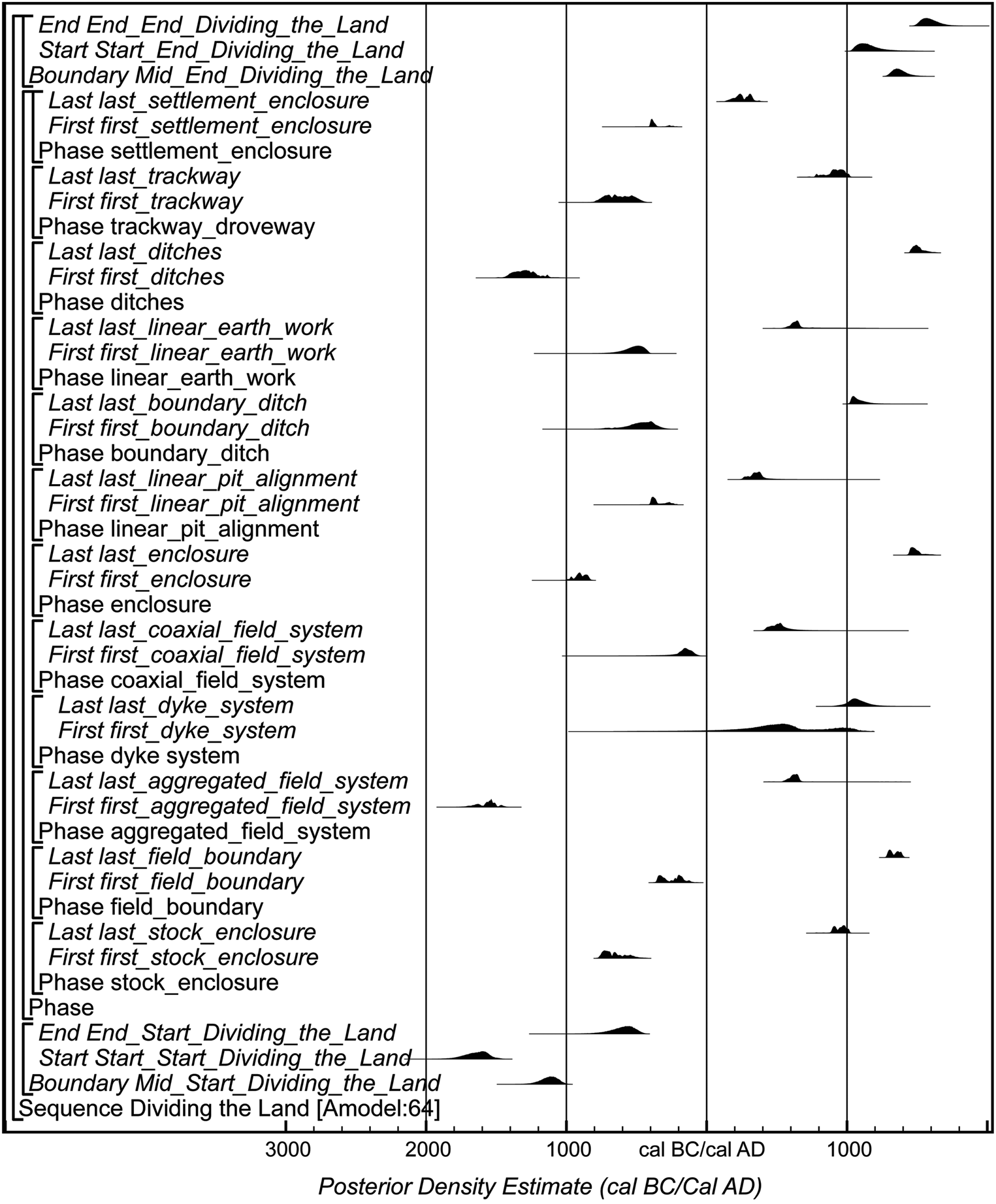
Figure 5. Overall structure of the chronological currency model for all the data analysed as part of ‘Dividing the Land’ project calculated using trapezium boundary parameters (Lee & Bronk Ramsey, Reference Lee and Bronk Ramey2012). The component sections of this model are shown in detail in Supplementary Material, Figures S88–S105. The distributions shown here are posterior density estimates produced through the Bayesian analysis. The large square brackets on the left-hand side of the figures, along with the OxCal keywords, define the model exactly, as does the code in the Supplementary Material.

Figure 6. Probability distributions of dates for the start of land divisions (some of the tails of these distributions have been truncated to enable detailed examination of the highest areas of probability), derived from the model shown in Figure 5.
Table 1. Highest Posterior Density intervals for the currency of different classes of land division in Yorkshire and the north-east Midlands, calculated by the currency model shown in Figure 5 and Supplementary Material Figures S88–S105.

After c. 800 cal bc, there is a marked change in the tempo and variety of land division, with the first appearance of a much wider range of types of land division between 800–400 cal bc. These include stock enclosures (770–505 cal bc; 95% probability; first_stock_enclosure; Figure S97), trackways (780–470 cal bc; 95% probability; first_trackway; Figure S94), boundary ditches (725–690 cal bc; 2% probability; or 665–305 cal bc; 93% probability; first_boundary_ditch; Figure S92), and linear earthworks (670–410 cal bc; 95% probability; first_linear_earthwork; Figure S104; Supplementary Material: Table 1).
Further types of land division begin to appear most probably after 400 cal bc, including the first appearance of linear pit alignments (410–230 cal bc; 95% probability; first_linear_pit_alignment; Figure S103), field boundaries (360– 115 cal bc; 95% probability; first_field_boundary; Figure S88), coaxial field systems (365–50 cal bc; 95% probability; first_coaxial_field_system; Figure S90), and settlement enclosures (415–350 cal bc; 81% probability or 290–230 cal bc 14% probability; first_settlement_enclosure; Figure S100).
The Use of Land Divisions
Figure 7 provides a long-term, landscape-scale impression of the intensity of change across the whole study region. Different types of land division had relatively long periods of use. This may derive in part from issues of taphonomy of the dated samples, and from histories of reuse, which may be important indications of related social practices (see below).

Figure 7. Top: schematic diagram showing the use of land divisions in Yorkshire and the north-east Midlands; horizontal bars represent the probability that a land division type was in use in each 100-year period (darker shading indicates higher probability). Bottom: Kernel Density Estimate for the plot of the overall distribution of posteriors associated with land division in the study area. The estimate is calculated for the whole dataset in the model shown in Figure 6. The black crosses represent the medians of the posteriors, with the medians of the calibrated results in grey. The medians indicate the distribution of results over time. The red crosses are uncalibrated medians of radiocarbon results. The Kernel Density Estimate is plotted against the calibration curve, which is shown in black.
Four ‘big trends’ of archaeological interest are highlighted by the KDE plot. First, there was a very low level of land division until c. 700 cal bc. This suggests that, in contrast to areas in southern Britain, Bronze Age fields were sparsely distributed across the region. This pattern appears to be real for three reasons.
We would expect negative features used for Bronze Age land division to be identified through excavation, if they existed, since later features on the same underlying geology are being found by excavation in the region. Secondly, the regional Bronze Age ceramic chronology is not so precisely dated that researchers would dismiss the opportunity to obtain radiocarbon measurements (see discussion of Romano-British material below). Finally, given that there is other evidence of Bronze Age activity in the region (e.g. Clay, Reference Clay and Cooper2006: 82–3; Richardson, Reference Richardson2011), this trend does not reflect a general absence of Bronze Age activity in the region.
A second ‘big trend’ occurs from c. 700 cal bc. A rapid increase in dated samples peaks in the first century cal bc, to gradually fall until c. cal ad 800. We suggest that this represents significant increases in land division from the earlier part of the Iron Age onwards, with the greatest intensity around 1 bc/ad. In terms of types of land division, enclosures, trackways, and linear earthworks mark the earlier part of the Iron Age, with new types of land division and increasing numbers of field systems documented in the later Iron Age and Romano-British periods.
A third trend consists of a further small rise in land division, peaking at c. cal ad 1000, which appears to correlate with the creation of villages and open fields in the Central Province (as defined by Roberts & Wrathmell, Reference Roberts and Wrathmell2002). This is generally assigned to the period from the eighth to tenth centuries ad (Rippon et al., Reference Rippon, Smart and Pears2015: 97–9, 329–31). The ‘Harrying of the North’ between ad 1069–70 (i.e. the campaigns to suppress northern England after the Norman conquest) has also been suggested to have resulted in the large-scale reorganization of landscapes across northern England, with villages established or rebuilt, and monastic estates founded (Hadley, Reference Hadley2000: 173), though others have suggested that the changes in settlement form reflect longer-term trends (Creighton & Rippon, Reference Creighton, Rippon, Dyer and Hadley2017: 76–7). The peak in our analysis appears to occur slightly earlier than the conquest—in the tenth and eleventh centuries cal ad. This suggests that enclosure in these centuries was part of a much lengthier pattern of change, underway before the Norman conquest. This would seem to be closer to the date range often suggested for the nucleation of settlement across the Central Province, and closer to the period of Scandinavian settlement and political control in this part of England under the Danelaw (i.e. northern, central, and eastern parts of early medieval England originally colonized by the Danes where a form of law that differed from West Saxon and Mercian laws prevailed).
A final important observation emerges from comparing the output of our two analytical approaches (Figure 7) with respect to the magnitude of these long-term changes. By comparing the trend after c. 700 cal bc and that around cal ad 1000 with the shape of the calibration curve, we can be confident that the trends are real, since they are independent of the calibration dataset.
The division of the land after c. 700 cal bc is of a much greater magnitude than that documented in any other period. There was a significant change in both the frequency and scale of land division in the last quarter of the first millennium cal bc: people became more active in dividing the land over the course of the Iron Age and employed new ways of doing this. This appears to have started with individual enclosures and land divisions perhaps associated with routeways and large-scale divisions across the landscape, to a gradual increase in emphasis on parcelling up the land over the Iron Age.
Discussion: Timescapes
The approach we have taken here can be classed as a ‘timescape’. This way of proceeding combines different analytical approaches to evidence for change across traditional culture historical divisions (Griffiths, Reference Griffiths2017). In this case, we have constructed robust, formal chronologies at a broad scale across these traditional culture historic divisions.
While not suggesting that the significant trends we have identified reflect the same concerns in all periods, we can say that the increased and intensive demarcation of space at given times suggests profound social change in terms of regulation of movement, access to land, and a heightened interest in demonstrating social inequalities, perhaps underscored by changing notions of land tenure and ‘ownership’.
The signal we have identified in Yorkshire and the northern Midlands over the Iron Age is most striking, and suggests an increasing emphasis on social hierarchy and identity. We may be able to see this in the limited number of prominent enclosed settlements such as Stanwick (Haselgrove, Reference Haselgrove2017). Notably, in the Arras burials of the Yorkshire Wolds (late fifth to early first century bc), we see a society interested in the production and display of identity and status (Giles, Reference Giles2012; Jay et al., Reference Jay, Haselgrove, Hamilton, Hill and Dent2012: 181). Outside our study areas, other evidence of social changes at this time include: the reorganization of the landscape in regions such as Wessex, which has been the focus of more research (Cunliffe, Reference Cunliffe2004); growing numbers of enclosed settlements that may indicate heightened social and ‘functional’ differentiation and, perhaps, instability (Thomas, Reference Thomas1997); and an increase in votive deposits and metalwork hoards (Bradley, Reference Bradley1990).
Our evidence suggests that societies in our region might have seen the beginnings of social differentiation several hundred years before the Late Iron Age floruit. From c. 700 cal bc onwards, patterns that are consistent with an increasing concern for regulating access to land and demonstrating associations with land emerge, perhaps to express individual and group identity and status, and, increasingly, as a form of social capital. This emphasis on land division, and the social processes it indicates, may not have taken place as early as in southern England, but it was well before the emphasis on differentiation and identity evident in the later Iron Age Arras burials, for example. We suggest that these later Iron Age processes of creating identities, social differentiation and these later patterns of inequality therefore may have much earlier roots, beginning with changes apparent in the rate of land division from c. 700 cal bc onwards. These land divisions may represent changing agricultural practices; however, direct comparative dating studies on the frequency of domesticates from across the study region (as well as other evidence for agricultural practices) would be needed to establish this independently. In a region where increasing evidence for interest in defining social identity in the later Iron Age is evident, these features can be seen as media through which people created markers of tenure, inheritance, and relatedness (Giles, Reference Giles, Haselgrove and Moore2007).
These social changes are emphasized by the changes in frequency and form of land demarcation over the Iron Age; this is not ‘simply’ an increase in the appearance of nucleated villages and open fields. Such frequency is unlikely to be an effect of the shape of the calibration curve or sample bias; those archaeologists researching the second half of the first millennium cal bc are often disinclined to obtain radiocarbon measurements because of a perception that the shape of the calibration curve will not be precise enough to address their research questions (Hamilton et al., Reference Hamilton, Haselgrove and Gosden2015). That we still identify this signal at a time when researchers might be less likely to submit radiocarbon samples—if they suspected material to be ‘Iron Age’—emphasizes the significance of this pattern. Moreover, our approach, emphasizes the scale of this change in organization of the landscape compared to what went on at other times.
The peak in evidence for land division in the second half of the first millennium cal bc is unlike that observed in any other period in Yorkshire and the north-east Midlands; the transformation was substantially different in nature from any earlier type of land division. This landscape reorganization was perhaps the most significant and profound reordering of space witnessed in the British countryside until the forced enclosures under the Acts of Parliament from the eighteenth century ad onwards (Wordie, Reference Wordie1983). Certainly, the changes that occurred over the first millennium cal bc were of a substantially different nature than any type of land division that had occurred before.
Switching between scales also allows critical consideration of regional trends in landscape development. Our region lacks the extensive rectilinear field systems that were widespread in southern Britain during the second millennium cal bc (Yates, Reference Yates2007). The earliest land divisions in Yorkshire and the north-east Midlands begin with localized aggregated enclosures, more characteristic of western and northern Britain. Our region's large-scale lowland field systems have a distinct identity within the landscapes of enclosure of the first millennium cal bc in north-western Europe (Løvschal, Reference Løvschal2020), though this pattern may also reflect the focus of development-led work on lower-lying landscapes.
The decline in the signal for land division in the Romano-British period may be due to several factors. A continuity of land divisions established in the first millennium cal bc may have played a part, as could a dearth of radiocarbon results obtained for samples from Romano-British features, for which typo-chronological dating is often more precise than for the preceding periods. Alternatively, the types of land division used in Romano-British societies could have relied less on substantial negative features, with boundaries defined by lighter fencing or hedging, for example.
Continuities in landscape organization into the early post-Roman period have been suggested at individual sites (e.g. Vervust, Reference Vervust, Kinnaird, Herring and Turner2020), while Rippon et al. (Reference Rippon, Smart and Pears2015) concluded that sixty-four per cent of excavated late Romano-British fields in lowland England and Wales (and seventy per cent in their Central Zone) had shared alignments with medieval field systems (see also Oosthuizen, Reference Oosthuizen2013). By contrast, Chadwick (Reference Chadwick2010: 444) argued for a discontinuity between Romano-British and medieval fields across the lowlands of our study region. Our own approach shifts the emphasis towards the reasons why the timing of land division was so variable across different regions, and especially how the rate of change varied.
We have identified a number of themes that could be addressed by future research. First, we need more robust data. The existing corpus of scientific dates for different types of land division (Figure 5) highlights a situation that can only be improved through chronologies for individual sites. In our study area, and north-western Europe generally, it is development-led archaeology that is leading this work. Marked variations in the intensities of land division through time have been identified, but finer resolution for our histories may be hindered by the plethora of terms used to describe categories of land division. This is an expression of a wider problem. For example, terms such as ‘Celtic fields’ refer to quite different land divisions in across north-western Europe (e.g. Whitfield, Reference Whitefield2017, Neilsen et al. Reference Nielsen, Holst, Gadd and Holst2018).
Second, we need to revisit our approaches to writing histories. While site-specific Bayesian models can radically alter our understanding of a sequence of change, we need to use different analytical lenses to think about the structure of our narratives and how we write about change (Griffiths, Reference Griffiths2017). The land divisions of the second and first millennia cal bc are a north-western European phenomenon (Løvschal, Reference Løvschal2020), and the ability to integrate British and European Iron Age evidence has been a subject of significant debate (Hamilton et al., Reference Hamilton, Haselgrove and Gosden2015). One cause of tension is that explanations of the links between Iron Age European communities are still led by material culture studies (e.g. Garrow et al., Reference Garrow, Gosden, Hill and Bronk Ramsey2009), although scientific dating has demonstrated that these models can be extremely misleading (Jay et al., Reference Jay, Haselgrove, Hamilton, Hill and Dent2012).
Here, we have focused on exploring a region over the very long term, using a variety of analytical approaches to shift our interpretative lenses. The trends we have identified contrast with the picture for southern England, but they also show similarities and differences with areas further afield. There is clear potential for future research on an even broader scale. We need chronometric data and a range of analytical approaches to write histories that use chronological (rather than typological or culture historic) frameworks to structure our narratives of social change at a transnational scale.
Conclusions
While several overviews of land division in Britain and northern Europe have been produced recently (e.g. Chadwick, Reference Chadwick2010; Ten Harkel et al., Reference Ten Harkel, Franconi and Gosden2017; Løvschal, Reference Løvschal2020), this study represents the first attempt at producing a long-term, geographically wide-ranging, robust chronology for the timing and tempo of land divisions that transcend traditional period boundaries for a region of the British Isles. It identified evidence for the origin of land divisions in Yorkshire and the north-east Midlands in the mid-second millennium cal bc, followed by an escalation after c. 700 cal bc and, again, a peak around cal ad 1000.
The taphonomy and associations of many of the dated samples in this study fall well-short of ideal sample selection criteria (Whittle et al., Reference Whittle, Healy and Bayliss2011: 38–40). Additional measurements from samples with well-defined taphonomies must be obtained. Where only material of uncertain taphonomy is available (e.g. disarticulated animal bones), multiple measurements on several types of materials or different species are required from the same context to assess chronological robustness. These samples should comprise single entity, ‘short life’ samples, with radiocarbon reservoirs that are clearly understood.
To work effectively with ‘difficult’ legacy data, we have developed an approach that analyses site-specific models of results with well-understood ‘logical scaffolding’ (Chapman & Wylie, Reference Chapman and Wylie2016) on the one hand, and KDE summaries on the other. Working from the site-specific, to currency models, to the regional longue durée provides complementary means to reassess such ‘difficult’ datasets. Furthermore, cutting across culture historical divisions offers a new perspective, allowing us to consider the relative scale of the radical changes in land organisation over the course of the Iron Age and after the Norman conquest in the context of a much longer trajectory of transformation. Analysing a specific type of land division, or class of monument, or ‘package’ defined by culture-historical parameters would not be sufficient to achieve this kind of long-term perspective.
Our approach has emphasized the significance of the scale of changes that affected the landscape after c. 700 cal bc, which would not have been apparent had we worked in a more traditional manner. The strength of this signal indicates a society where ideas about identity, status, and control of resources were being played out on the landscape in new ways, which dramatically escalated over several centuries, and which ultimately may have led to the social differentiation apparent in the first century cal bc. It is only by combining analytical approaches and taking the long view of land division that we begin to recognize quite how significant these changes were.
Supplementary Material
To view supplementary material for this article, please visit https://doi.org/10.1017/eaa.2021.48.
Acknowledgements
This work was supported by Historic England under Grant 7710. We would like to thank all the Historic Environment Record Officers, archaeologists, and researchers who allowed us to collect data and generously responded to our queries. We have thanked these hard-working people in the Supplementary Material, as there are so many; we hope they understand! If we have forgotten anyone we apologize. We would like to thank our reviewers for their attention and helpful suggestions. We also thank the editor for her patience during our Covid-19-delayed resubmission.


 Open access