Introduction
Explosive volcanic eruptions eject huge amounts of dust and gases into the atmosphere. The far-traveled volcanic aerosols in the atmosphere eventually settle to the ice sheet, forming a tephra layer or an acidic layer in the fallen snow. Ice cores from polar regions, therefore, provide a detailed record of local and distal volcanic eruptions. Though recent ice-core studies have clarified volcanic chronology (e.g. Reference Legrand and DelmasLegrand and Delmas, 1987; Reference Delmas, Kirchner, Palais and PetitDelmas and others, 1992; Reference Cole-Dai, Mosley-Thompson and ThompsonCole-Dai and others, 1997) and its relation to climate change (e.g. Reference Hammer, Clausen and DansgaardHammer and others, 1980; Reference Palais, Sigurdsson, Berger, Dickinson and KidsonPalais and Sigurdsson, 1989), only limited studies have been done on volcanic activities back to the last glacial period (e.g. Reference Zielinski, Mayewski, Meeker, Whitlow and TwicklerZielinski and others, 1996; Reference Hammer, Clausen and LangwayHammer and others, 1997).
The present study reveals tephra layers found in a 2503 m deep ice core from Dome Fuji, Antarctica (Dome-F Deep Coring Group, 1999), spanning three glacial-interglacial cycles of the last 340 ka (Reference Watanabe, Kamiyama, Motoyama, Fujii, Shoji and SatowWatanabe and others, 1999).
Tephra Layers
Stratigraphic observation was carefully carried out at Dome Fuji station and the home cold laboratory. We found two kinds of stratigraphical features: one is a "cloudy band" of light-gray color without color gradation in the band; the other is a "tephra layer", recognized because of features such as yellowish or brown color, shade in color and/or visible particles under a 30X magnifying glass.
We found 821 cloudy bands in total. There are three cloudy-band zones in the depth ranges 480-715, 940-1130 and 1760-2050 m. Numbers of cloudy bands found in these zones are 311, 155 and 297, respectively. A few cloudy bands are found at other depths. We have not examined the particles yet, but some of them are likely to be volcanic because the upper cloudy-band zone covering the Last Glacial Maximum corresponds to the 2000 cloudy bands, composed mainly of glassy and crystalline fragments of <5 µm diameter, in the Byrd ice core deposited during 15-17 ka BP (Reference Gow and WilliamsonGow and Williamson, 1971).
We found 25 tephra layers by continuous stratigraphic observation. Figure 1 shows photos of 16 tephra layers as examples. Some of the layers have a uniform shade of color, suggesting continuous fallout of tephra ejected to the stratosphere. Tephra layers with distinct shade of color at the lower boundary were probably due to tephra fallout through the stratosphere from the source volcano following fallout through the troposphere. The tephra layers at 1778 and 1785 m depth are double-layered with a thicker, darker layer at the bottom. The double-layered tephras are considered to indicate repeated eruptions from a volcano.
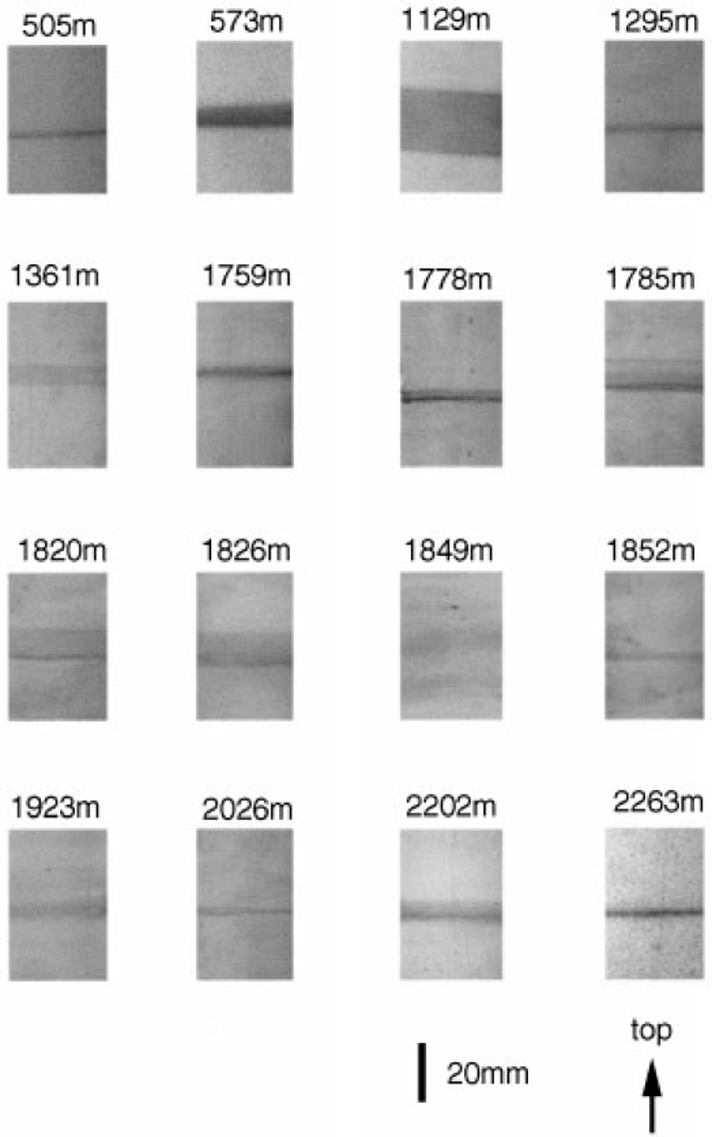
Fig. 1 Sixteen examples of tephra layers found in a 2503 m deep Dome Fuji ice core.
Table 1 shows a list of tephra layers. Ages of tephra layers are calculated by using the relation between the «5180 value of snow in the area with «5180 >-51 per mil in east Dronning Maud Land and a simple steady-state ice-flow model proposed by Reference Dansgaard and JohnsenDansgaard and Johnsen (1969) (Reference Watanabe, Kamiyama, Motoyama, Fujii, Shoji and SatowWatanabe and others, 1999). The chronological accuracy for this time-scale calculation could be estimated as about 20% for long-term variations. The thickness of the tephra layers is in the range 1-24 mm. The initial thickness of the tephra layers at their formation on the ice-sheet surface, estimated by using the steady-state model, is shown in Table 1. The duration of tephra fallout onto the ice sheet is also calculated.
Table 1. Tephra layers found in a Dome Fuji deep ice core
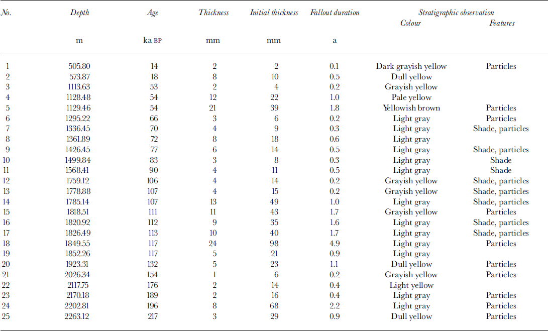
Figure 2 shows the vertical distributions of actual and initial tephra thickness and duration of tephra fallout. The median tephra thickness is 15 mm, which corresponds to the median fallout duration of 1.5 years.
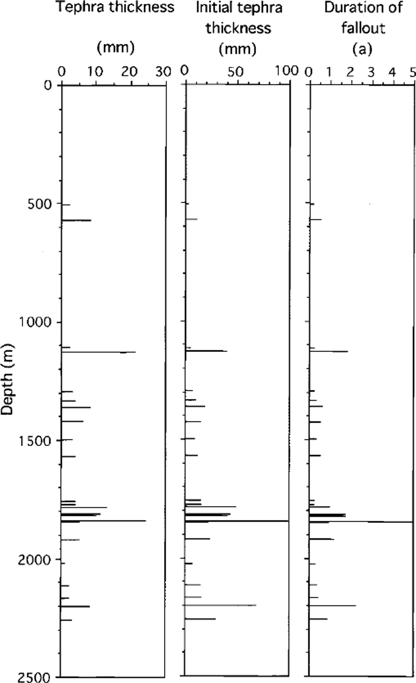
Fig. 2. Vertical distributions of actual and initial thicknesses, and fallout durations of 25 tephra layers.
The thickest tephra layer at 1849 m depth is 98 mm thick and took about 5 years to be deposited on the ice-sheet surface. Since the residence time of stratospheric aerosols is about 1.5 years, as estimated from the decrease in the nuclear bomb radioactivity of snow in Antarctica (Reference Pourchet, Pinglot and LoriusPourchet and others, 1983), the duration of the eruption which caused the 98 mm thick tephra layer at Dome Fuji 117 ka BP is thought to have lasted and kept ejecting a large amount of tephra into the atmosphere for >3 years.
Comparison with Vostok Ice Core
More than 30 tephra layers were found in the 3G, 3G1,4G2, 5G, 5G1 and BH Vostok (Antarctica) ice cores (Reference BasileBasile, 1997). To correlate tephra layers in the Dome Fuji and Vostok ice cores, we superimpose the oxygen and hydrogen stable-isotope ratio on the vertical tephra distributions of the Dome Fuji and Vostok ice cores, respectively, as shown in Figure 3. Judging from the position of each tephra layer on the isotope profiles, eight tephra layers, located at depths of 505,1128 or 1129,1362,1568,1850, 2026, 2118 and 2170 m in the Dome Fuji ice core probably correspond to those at depths of 369, 945, 1279, 1508 or 1510,1995, 2287, 2325 and 2498 m, respectively, in the Vostok ice core.
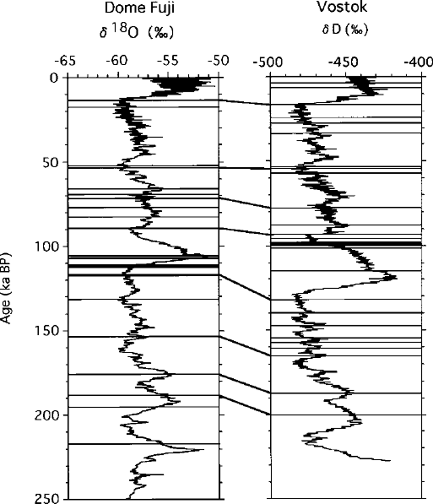
Fig. 3. Correspondence of Dome Fuji tephra layers with those in the Vostok ice core based on the tephra positions on oxygen and hydrogen stable-isotope profiles, respectively. Only eight tephra layers found in both ice cores correspond.
The tephra layer at 1849 m depth in the Dome Fuji ice core is the thickest, at 24 mm thick; the corresponding layer at 1996 m depth in the Vostok ice core has a similar thickness, 20 mm. The source volcano of the Vostok tephra layer is considered to be Mount Berlin in Marie Byrd Land on the basis of the chemical composition (Reference BasileBasile, 1997). The age of the tephra layer at 1849 m depth, -117 ka BP, is different from that of the corresponding Vostok layer at 1996 m, 142 ka BP, which shows good agreement with the 40A/39A age of volcanic ash of Mount Berlin, 141 ka BP (Reference BasileBasile, 1997).
There are some probable reasons for a limited correspondence between tephra layers in Dome Fuji and Vostok ice cores. One of these is the absence of snow layers after tephra deposition due to the erosion of surface snow by strong wind. But if we consider the cloudy bands in the Dome Fuji ice cores as being of volcanic origin, most of the Dome Fuji tephra layers correspond to Vostok layers.
Chemical Composition
We determined chemical compositions of glass shards which were found in two specific tephra layers at depths of 573 and 2202 m (Table 1). Ages of these layers are estimated to be -18 and -196 ka BP, respectively. Both layers are 8 mm thick, but the estimated durations of deposition are -0.5 and -2.2 years, respectively. The 573 m layer is yellowish-brown and the 2202 m layer is pale-yellowish.
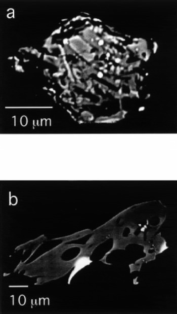
Scanning electron microphotographs (SEMs) of glass shards from the 573 and 2202 m layers, whose average sizes are 20-50 µm, are shown in Figure 4. The grain-size suggests that the source volcanoes are located in and around Antarctica. The 573 m tephra is commonly blocky and poor in vesicularity (Fig.4a). It shows pilotaxitic texture. It is composed of euhedral microphenocryst and subhedral microlite, which are commonly plagioclase, pyroxene and opaque minerals, with a minor quantity of interstitial glass. The 2202m tephra is glassy and moderately vesiculated (Fig.4b). It shows fluidal morphology.
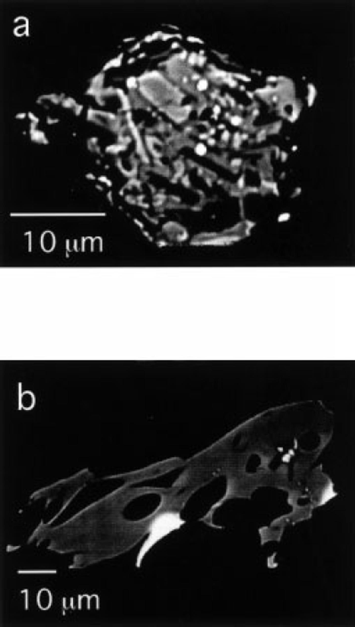
Fig. 4. SEMs of thin sections of tephras from layers at depths of (a) 573m and (b) 2202m.
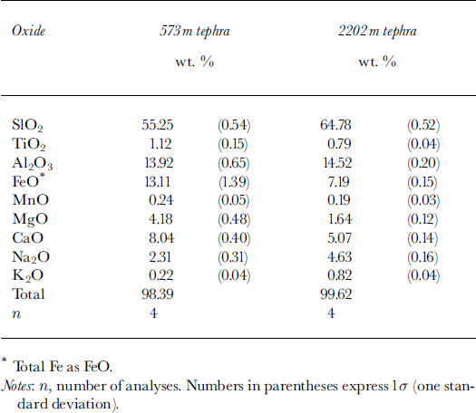
Major element compositions of tephras, including SiO2, TiO2, Al2Os, FeO, MnO, MgO, CaO, Na2O and K2O, were determined using a JEOL-JXA8800 wavelength-dispersive electron microprobe analyzer with the ZAF correction method. The tephras were analyzed with accelerating voltage of 15 keVand electron-beam current of 12 nA. The electron-beam diameter was set at >5 µm to minimize migration of sodium during the analysis. The 573 m tephra was analyzed with a broad electron-beam (10-15 µm) in order to obtain an average chemical composition of ground-mass without microphenocrysts. The accuracy and precision of the analyses were checked by repeated analyses of glass and mineral standards.
Mean chemical compositions of the tephras are shown in Table 2. The compositions (andesitic and dacitic poor in K2O, respectively) are typical of subduction volcanism. The 573 m tephra is basaltic andesite. The tephra is similar in composition to aphiric basaltic andesite from Visoko Island in the South Sandwich Islands, Southern Ocean (Reference BakerBaker, 1978). The 2202 m tephra is homogeneous dacitic glass. This is similar in composition to aphyric dacitic lava from the northern part of Candlemas Island in the South Sandwich Islands (Reference BakerBaker, 1978; Reference TomblinTomblin, 1979).
Table 2. Chemical compositions of tephras from layers at depths of 573 and 2202 m
It is inferred that both the 573 and 2202 m tephras originated from volcanoes in the South Sandwich Islands, which are about 3000 km from Dome Fuji. Glass shards, whose source is considered to be the South Sandwich Islands, were found in ice cores from Mizuho (Reference Higashi and FujiiHigashi and Fujii, 1994) and Vostok stations (Reference Palais, Mosley-Thompson and ThomasPalais and others, 1987) and in bare-ice areas near the Yamato (Reference Katsushima, Nishio, Ohmae, Ishikawa and TakahashiKatsushima and others, 1984; Reference Nishio, Katsushima and OhmaeNishio and others, 1985) and Sør Rondane Mountains (Reference Naraoka, Yanai and FujitaNaraoka and others, 1991), Dronning Maud Land. This suggests that tephra dusts from the South Sandwich Islands were widely dispersed onto the East Antarctic ice sheet through the atmospheric transport paths proposed by Reference CarletonCarleton (1981) and Reference Thompson and Mosley-ThompsonThompson and Mosley-Thompson (1982), and supports our results.
Conclusions
We found 25 tephra layers, which have the features of yellowish or brown color, shade in color or visible particles under a magnifying glass, in a Dome Fuji deep ice core. The median thickness at deposition onto the surface is 15 mm, which corresponds to a median fallout duration of 1.5 years. The thickest tephra layer, at 1849 m depth, is 98 mm in initial thickness and took about 5 years to be deposited onto the ice-sheet surface.
Two tephra layers at depths of 573 and 2202 m are thought to have originated from the South Sandwich Islands, given the size of tephra shards, >20µm in diameter, and their major chemical composition. Based on preliminary morphological observation by scanning electron microscope, the tephra layer at 1361 m depth is composed of glassy shards >20 µm in diameter, suggesting local volcanic origin. The thickest tephra layer at 1849 m depth corresponds to the tephra layer with a similar thickness of 20 mm at 1996 m depth in the Vostok ice core. The source volcano of the tephra layer is considered to be Mount Berlin, Marie Byrd Land. These facts suggest that the tephra layers in the Dome Fuji ice core are due to volcanism in and around Antarctica.
Among the 25 tephra layers, only eight correspond to the Vostok layers, judging from the position of each tephra layer on the Dome Fuji and Vostok isotope profiles. But if we consider the cloudy bands to be of volcanic origin, all of the Dome Fuji tephra layers correspond to Vostok layers. This suggests that some of the cloudy bands found at 821 m depth, concentrated in the depth ranges 480-715, 940-1130 and 1760-2050 m, are possibly of volcanic origin.
The age of the tephra layer at 1849 m depth, -117 ka BP, is different from that of the corresponding Vostok layer at 1996 m, 142 ka BP, which shows good agreement with the 40 A/39 A age of volcanic ash of Mount Berlin, 141 ka BP. This suggests that the chronological accuracy for Dome Fuji time-scale calculation could be estimated as about 20% for long-term variations.
Acknowledgements
We would like to express our hearty thanks to the wintering members of the Japanese Antarctic Research Expeditions who gave us extraordinary support for the Dome Fuji Project during 1991-97. Special thanks go to R. J. Delmas of the Laboratoire de Glaciologie et Geophysique de l’Environnement,Grenoble, France, for providing valuable comments and the doctoral thesis of I. Basile.