Introduction
The Arctic Institute of North America decided in 1959 to undertake a comprehensive programme of investigations on Devon Island, one of the Queen Elizabeth Islands of the Canadian Arctic Archipelago. The objective of the work was to understand better the interaction of ice, sea, and atmosphere. In the summer of 1960 the first base camp was established near Cape Skogn, from where the three-year programme was begun in April 1961 (Reference ApollonioApollonio and others, 1961).
As part of this programme I had the opportunity to undertake geoelectrical measurements during June and July, assisted by J. P. Greenhouse and W. P. Molson. In 1961 the measurements were made mainly on the Sverdrup Glacier and during the summer of 1962 J. P. Greenhouse concentrated his investigations on the ice cap (Reference KoernerKoerner and others, 1963; Reference GreenhouseGreenhouse, unpublished).
I should like to thank the Arctic Institute of North America, the field leader, S. Apollonio, my two assistants, and all those who helped me. I express again my gratitude to the Swiss P.T.T., who not only granted me leave, but also permitted me to take into the field part of the necessary equipment belonging to the Research Department.
Background
When I went north in 1961 I had already made measurements of the resistivity of glacier ice at several places in the Swiss Alps. There I had made the discovery that it is possible to make such investigations without great technical difficulties if suitable instruments are available. Because of the extremely low conductivity of the ice in the Alps every surface layer with relatively high electrical conductivity disturbs the sounding of the ice masses lying underneath to a very large extent. It was therefore very satisfying from a technical point of view, when H. Röthlisberger wrote me that in Greenland the resistivity of the ice amounts to only about 0.1 MΩ.m.(= 100 kΩ.m.), whereas we found in the Alps values of up to 100 MΩ.m.
The difference in conductivity at a ratio of about 1 : 1,000 poses, however, a problem, the investigation of which promises interesting results. The investigations on Devon Island were therefore planned from the start also to provide results in this direction. We therefore made measurements in the ice of the frozen Jones Sound, in the ice cover of a fresh-water lake, in former crevasses that became filled with melt water and froze again, and in other ice formations. These measurements will be reported in a final report on the work done in 1961, while the present article contains the description of soundings only.
Sverdrup Glacier
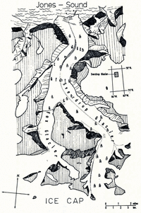
The main objective in 1961 was the depth sounding in the Sverdrup Glacier (Fig. 1), from its head at the edge of the ice cap to its terminus, in as complete a manner as possible. The glacier is about 20 km. long and on an average about 2.5 km. wide. Its valley, which runs north-south, is bordered by steep walls with an average height of about 300 m. The transition to the ice cap lies at about 900 m. above sea-level. The terminus at Jones Sound lies at lat. 75° 45′ N., long. 83° 10′ W.

Fig. 1. Map of Sverdrup Glacier with the positions of the profile centres
During the melting period it is often impossible to cross from the glacier to the steep walls, which consist of Precambrian metamorphic rocks, because along the line of contact between country rock and glacier runs a depression which is often 50 m. deep and occupied by a raging torrent of melt water.
Equipment and Working Conditions
One of the two tent camps was near the centre of the glacier (Fig. 1, near profile point 2), the other in the upper third (near point 25, Fig. 1). All measuring points had to be approached on foot, therefore it was an advantage that the entire equipment necessary for one measurement did not weigh more than about 50 kg.
The cables carried were always the main weight. We usually required six reels, each with 300 to 500 m. of cable. The tensile strength of the cables had been increased through the addition of a steel wire of 0.2 mm. diameter. This steel wire, in combination with six copper wires of 0.2 mm. diameter, formed the conductor, which was insulated by 0.35 mm. of polyethylene covering. The necessary voltage was supplied by small radio batteries of 67.5 V. each; up to five of these were connected in series. The current, which was applied to the substrate through steel rods, was measured with a standard laboratory instrument (Simpson); to measure the voltage across the potential electrodes, a vacuum-tube voltmeter with extremely high input resistance (Keithley Model 600A) was used. Since the input resistance of this instrument, even at the highest sensitivity of 10 mV. full scale, is still 1011 Ω. the voltages could be read without compensation. For the current electrodes we used steel rods, about 70 cm. long, with sharp points, the contact resistance of which could, when necessary, be reduced to a great extent by applying salt. For potential sondes we usually employed non-polarizing Cu/CuSO4 electrodes with about 50 cm2 active surface and saturated electrolyte. Only when the distance between electrodes became less than 1 m. did we use copper rods and, for very small distances, also short nails as potential sondes.
The currents applied to the substrate were as a rule of the order of 1 mA. The differences in potential generated by the currents between the potential sondes attained, even for the largest distances, without exception, values of over 10 mV., in most cases over 50 mV. For distances below 10 m. they were usually more than 1 V.
Generally the Schlumberger configuration was used for the arrangement of the electrodes. In a few instances the Wenner configuration was used for control purposes.
When we began the measurements, the glacier was covered with a solid layer of snow, which, however, soon turned into slush. After that water began to flow everywhere until finally the solid ice appeared. Even a 30 cm. layer of water and slush did not disturb the measurements much, if one ignores the fact that such conditions hinder one’s movements, the staking out of the profiles, and the setting out of the electrodes. Nevertheless, with the exception of profile 5 (see Fig. 1), which was begun during a heavy fall of wet snow on a foggy day, no single profile had to be abandoned prematurely or repeated.
Results
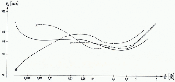
The position of the centre points of the profiles is shown in Figure 1, and the structure of the substrate can be taken from Table I. The resistivity measurements at each profile were analysed by superposition of the observed data on master curves for horizontal layering (i.e. layers of uniform thickness parallel to the surface). Three- or four-layer curves were mainly used. Layer thicknesses and assumed resistivities for the individual layers are given in Table I for all profiles, together with total ice thickness and some additional information on dates, configuretion and profile length. In Figures 2 and 3 the apparent resistivity versus electrode separation curves are plotted for the Wenner and Schlumberger configuration respectively. These graphs deviate somewhat from the standard presentation (cf. Fig. 4). Instead of plotting the electrode separation a or l in metres, normed values were used in the abscissa, i.e. a/h in Figure 2 and l/h in Figure 3, a being
Table I Thickness and Resistivity of Ice and Rock strata


Fig. 2. Curves of apparent resistivity versus wormed electrode separation relative to total ice thickness h, Wenner configuration

Fig. 3. Curves of apparent resistivity versus nonmed electrode separation relative to the total ice thickness h, Schlumberger configuration

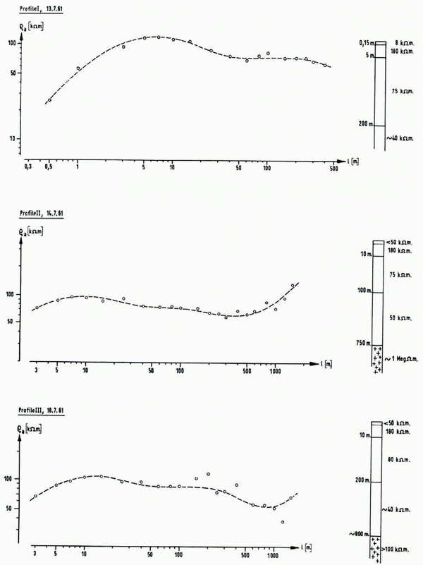
Fig. 4. Measurements using Schlumberger configuration on the ice cap. Profile I was measured under favourable, profile II under medium, profile III under very unfavourable conditions
Only three profiles were measured, roughly 300 m. apart, near “Ice Cap Station” (lat. 75° 28′ N., long. 83° 10′ W., 1,500 m. a.s.l.). To make it possible to indicate the accuracy of the individual measurements, the results of this series of measurements have been inserted as individual points in Figure 4, and the scale for the abscissa has not been normed. Here the value of l that belongs to each point equals one-half of the distance between the outer electrode through which the current has been led into the substrate. Thus the usual method of displaying the measurements in the Schlumberger method has been used.
Profile I was measured on 13 July 1961, under favourable conditions. The temperature was below freezing and a thin layer of fresh snow had formed a solid crust over the existing layer of slush.
On the following day it was considerably warmer. In some places one broke through the crust into 20 cm. of slush. Profile II was thus measured under conditions that were already less favourable but about the same as those generally encountered. Finally profile III was measured under the poorest conditions imaginable. The large expanse of the ice cap was covered with a layer of remnants of snow and melt water that was in places knee-deep. In some parts the slush was still stationary, in other places it was slowly moving. Channels of water had divided the whole plain into innumerable patches. In addition to this there was thick fog, which restricted visibility to about 200 m. At certain points the potential sondes and electrodes were in the middle of a stream of water. Other points selected previously could not be reached at all. Frequently the marker flags were swept away before the electrodes could be installed. Neither the direction of the profile nor the distance could be kept correctly. The combination of all these difficulties led to results that showed so much scatter that any evaluation would have been impossible if they could not have been supported by other measurements.
In profiles I and II, as well as in most of those on Sverdrup Glacier, the scatter of the observations was much smaller. However, the final accuracy of a sounding is not so much affected by this scatter as by the fact that the true distribution of resistivities in the ground is not identical with the models for which the master curves have been calculated. Under favourable conditions for a single profile the accuracy can be estimated at ±30 per cent, while the average of the thicknesses determined on Sverdrup Glacier is probably as accurate as ±10 per cent. Furthermore, it should be remembered that the method does not provide values for a definite spot but an average value for a larger area.
Under the conditions encountered on Devon Island resistivity values could often be determined with much higher accuracy than the thickness of the various layers. It is not possible for instance to give a reliable depth figure at profile III, while it is certain that the resistivity of the ice is between 50 and 100 kΩ.m.
A resistivity of less than 100 kΩ.m. for the bulk of Sverdrup Glacier was obtained at the majority of the profiles and on the ice cap as well. Only at a few places were far higher values observed for restricted masses of ice. For example, in the region of profile 27, some lenses of ice with a high resistivity were encountered. Because they extended to the surface, the apparent resistivity ρ a amounted to about 3 MΩ.m. for a distance between electrodes of about 10 m., so that it was not possible to use this profile for inclusion in Figure 3. For large distances between electrodes ρ a decreased again and for a distance between the two current electrodes of 1 km. a normal value of 80 kΩ.m. was obtained. For still greater distances the bedrock, with its lower conductivity, increased the values again. The measurements were discontinued at an electrode distance of 1.8 km. when the last ρ a value was 110 kΩ.m. Smaller masses of ice with low conductivity were also found for profile 34 (Fig. 3).
With one exception the apparent resistivity attained a minimum value and then grew larger. This shows that the rocky substrate has a still smaller conductivity than the masses of ice. The resistivities of ice and rock are in the proportion of about 1 : 10.
Profile 16 (omitted in Fig. 3), taken near the junction of the Sverdrup Glacier with the Fox Glacier, which also originates in the ice cap, makes a remarkable exception, because here the apparent resistivity falls rapidly with increasing electrode distance and finally flattens out at about 10 kΩ.m. Evidently the ice lies here on a foundation of higher conductivity. A moraine crosses the glacier to imply that the Fox Glacier is not a tributary of the Sverdrup Glacier but that the latter flows towards the Fox Glacier for a certain distance until both meet, at which place the morainic material is accumulating. Thus not only did considerable walls of sediments come into existence on the surface, but extensive accumulations have apparently built up at the bottom. In late summer this area is covered with a lake of melt water, which indicates that the surface of the ice is inclined from both sides towards the point of impact.
Apart from the exceptions mentioned, the results of the measurements show a remarkable uniformity. This indicates that the ice masses of the Sverdrup Glacier have, with few exceptions approximately the same resistivity as the ice of the ice cap.
For the interpretation of the measurements these conditions were ideal, since the higher conductivity of the upper layers hardly disturbed the depth soundings. Under conditions of sufficient space it should be possible to measure depths of several kilometers with the aid of very long profiles. At times, however, inductive voltages, which are caused by Earth-magnetic variations, can disturb the measurements severely. Furthermore, electrostatic charges during snow-storms and during freezing of the surface can disturb the measurements. One has also to prevent radio waves that are picked up by the cables from blocking the vacuum-tube voltmeter, or, which is worse, causing erroneous indications through recgifying effects. The worst enemy, however, is moisture, which destroys the insulation. Frequent insulation tests are therefore necessary and one has to make sure that creepage currents do not falsify the measurements.
An immediate rough evaluation of the measurements on the spot helps to discover omissions that cannot be corrected later. Because geoelectrical soundings are easy to evaluate, this should always be done, no matter how tired the worker may get, or how impressed he may be by the overwhelming beauty and the sublime quietness of an Arctic fine-weather day.