


Introduction
The predatory nature of felids conflicts with human interests and this, coupled with the transformation and loss of habitat they occupy, has resulted in the reduction or regional extirpation of many carnivore populations (Brown & López-González, Reference Brown and López-González2000; Foreman et al., Reference Foreman, List, Dugelby, Humphrey, Howard and Hodsworth2000b; Treves & Karanth, Reference Treves and Karanth2003). One particular area where carnivores have suffered such declines is the USA-Mexico border region, as exemplified by the loss of the grizzly bear Ursus arctos, Mexican wolf Canis lupus and jaguar Panthera onca. Recently, however, records of jaguars in Arizona (Brown & López-González, Reference Brown and López-González2000; Grigione et al., Reference Grigione, Scoville, Scoville and Crooks2007) have generated renewed interest in the conservation of Neotropical cats in this region.
Three Neotropical cat species reach the USA-Mexico border region at the northern limits of their range: the jaguar, ocelot Leopardus pardalis and jaguarundi Herpailurus yagouaroundi. In the USA there are no known breeding populations of jaguars or jaguarundis and only two such populations of ocelots (Nowell & Jackson, Reference Nowell and Jackson1996; Grigione et al., Reference Grigione, Caso, List and López-González2001). All three species are protected as endangered by the US Endangered Species Act and by similar Mexican legislation (SEMARNAT, 2002). Neotropical felid populations in the border region are threatened by land development and land conversion, predator control by cattle growers, an increase in disease exposure, construction of highways, international bridges and immigration-control infrastructure (Brown & López-González, Reference Brown and López-González2001; Grigione et al., Reference Grigione, Caso, List and López-González2001; Grigione & Mrykalo, Reference Grigione and Mrykalo2004; Marris, Reference Marris2006).
To incorporate rare felids into regional habitat conservation plans this study develops a preliminary blueprint of important conservation areas, composed of core habitats and corridors, for each species of Neotropical cat in the border region. This was done by: (1) the compilation of reliable sightings for each species in the border region from the early 1900s to 2003, (2) field surveys in the border region to ascertain the presence of felids (Grigione et al., Reference Grigione, Scoville, Scoville and Crooks2007; Crooks et al., in press), and (3) the coordination of a geographical information system (GIS) habitat mapping workshop. For the latter, 29 scientists and conservationists working in the border region contributed important information about the distribution and status of all three species.
Because of limited quantitative data and the urgency of implementing conservation planning, workshops involving consultation from many scientists have been used to fill critical gaps in information (Bojóquez-Tapia et al., Reference Bojóquez-Tapia, Brower, Castilleja, Sánchez-Colon, Hernández and Calvert2003). Consultations have been widely used to identify priority regions for conservation (Arriaga et al., Reference Arriaga, Espinoza, Aguilar, Martínez, Gómez and Loa2000) and to prioritize habitat areas for rare carnivores and other species (Wikramanayake et al., Reference Wikramanayake, Dinerstein, Robinson, Karanth, Rabinowitz and Olson1998; Palma et al., Reference Palma, Beja and Rodrigues1999; Lunney et al., Reference Lunney, Matthews, Moon and Ferrier2000; Sanderson et al., Reference Sanderson, Redford, Chetkiewicz, Medellín, Rabinowitz, Robinson and Taber2002; Thorbjarnarson et al., Reference Thorbjarnarson, Mazzoti, Sanderson, Buitrago, Lazcano and Minkowski2006). Maps that identify priority areas for single species, such as the American crocodile Crocodylus acutus (Thorbjarnarson et al., Reference Thorbjarnarson, Mazzoti, Sanderson, Buitrago, Lazcano and Minkowski2006), jaguar (Sanderson et al., Reference Sanderson, Redford, Chetkiewicz, Medellín, Rabinowitz, Robinson and Taber2002), and tiger Panthera tigris (Wikramanayake et al., Reference Wikramanayake, Dinerstein, Robinson, Karanth, Rabinowitz and Olson1998), have been synthesized during mapping workshops attended by scientists from many countries. The consensus amongst participants must be considered one of the largest benefits of holding such a workshop and has played an important role in ongoing conservation work. Without a USA-Mexico consensus regarding which populations and habitats are most important for each species of Neotropical cat in this region, persistence of these populations will be compromised, particularly in light of land development pressures and security issues spanning the USA-Mexico border. This study provides a framework for such a consensus.
Methods
Our study area corresponds to the pre-industrial northern historical range of the three species, consisting of the US states of Arizona, New Mexico and Texas, and the Mexican states of Sonora, Chihuahua, Coahuila, Nuevo León and Tamaulipas. This area corresponds approximately with the northern and southern limits of the Sonoran Desert, Sinaloan thornscrub, Sierra Madre Occidental pine-oak forest, Chihuahuan Desert, Tamaulipan mezquital, and Western Gulf coastal grassland ecoregions (Olson et al., Reference Olson, Dinerstein, Wikramanayake, Burgess, Powell and Underwood2001). Despite the fact that this area includes many state boundaries and a militarized international border, our objective was to create a seamless database and landscape for the borderland region (Scott et al., Reference Scott, Davis, Csuti, Noss, Butterfield and Groves1993). The project area was divided into eastern and western bioregions. The western bioregion encompassed the Sierra Madre Occidental and Sky Islands, and the eastern the Sierra Madre Oriental. These divisions were made because there are two distinct habitat areas in the border region, and for practical cartographic purposes.
In 1998 a sightings database (containing genus, species, age, sex, date observed, number of individuals, county, state, country, latitude, longitude, location, evidence, observer/collector, source, activity of felid, and other available information) was established for each felid species in the border region. Data were obtained by conducting interviews with biologists from state and federal agencies, naturalists, academics, graduate students, non-profit organizations and natural heritage programmes. Each sighting was classed 1–3 using the criteria developed by Tewes & Everett (Reference Tewes, Everett, Miller and Everett1986) for evaluating ocelot and jaguarundi sightings in southern Texas. For our study only Class 1 sightings (sightings made by a credible observer, with physical evidence such as a carcass) were retained for subsequent analyses because Class 2 (detailed description of event provided by reliable observer, no physical evidence) and 3 (details of observer vague, no physical evidence) sightings were not as reliable. GIS data used comprised elevation data from USGS (2006), the World Database on Protected Areas (2003), historic species ranges digitized from range maps (Nowell & Jackson, Reference Nowell and Jackson1996), and topographical data (ESRI, 2003). Sighting records were transferred to a GIS and plotted for each bioregion. This information was used as a starting point for the workshop.
In December 2003 29 scientists and conservationists from seven USA states and four Mexican states attended a workshop where they could review the results of each sighting map (above) for each species and answer more detailed questions regarding species distribution and status. Specifically, participants were asked to identify important habitat areas, dispersal corridors, required or existing underpasses, and to characterize habitat areas and corridors (described below). In addition, they were asked to give additional sighting information not previously identified. To ensure that adequate knowledge existed for the entire border region each participant was asked to delineate his or her area of knowledge for each species onto maps of the border region.
Each participant was also asked to delineate Cat Conservation Units and Cat Conservation Corridors for their area or areas of knowledge onto respective maps for each species. Units were defined as habitat areas important to the long-term survival of a species, often where populations are currently located or areas likely to support relocated populations. Corridors were defined as linear or curvilinear strips of habitat connecting otherwise isolated Units that had documented Class 1 sightings.
Although there was a primary author for each Unit or Corridor, the process of delineating boundaries and ranking areas was a group effort, utilizing all expertise and information available. Differences in opinion were worked out consensually (Thorbjarnarson et al., Reference Thorbjarnarson, Mazzoti, Sanderson, Buitrago, Lazcano and Minkowski2006). Each participant filled out a data sheet for each Unit and Corridor they identified, per species, to rank and characterize each according to population status, prey species present, threats, land ownership and level of land protection. To determine the level of current land protection, the World Database on Protected Areas (WDPA, 2003) was intersected with each Unit and Corridor. The result was a measure of how much each Unit and Corridor is currently protected by the six IUCN management categories (WDPA, 2003).
To establish priorities for research and conservation a generalized weighting scheme was established. Units were ranked by: (1) connectivity between the Unit and other habitat areas, (2) habitat quality, (3) size, (4) hunting of felids, (5) hunting of prey, (6) population status, (7) threats from roads, (8) effectiveness of protection, and (9) human density in and around the Unit. Corridors were ranked by (1) continuity of connectivity, (2) habitat quality, (3) width, (4) length, (5) hunting of felids, (6) hunting of prey, (7) gaps/barriers, (8) threats from roads, (9) effectiveness of protection, and (10) human density in and around the Corridor. Each participant was asked to rank these factors by importance from 1 (most important) to 9 (least important) for each species.
Values from all participants were averaged for each factor by species, and the sum of all factors (for Corridors and Units separately) was normalized to 100%. This provided a measure of importance of each factor for each species. Each participant then ranked the importance of each factor, as good (2), neutral (1) or bad (0) as applied to a specific Unit or Corridor. When multiplied by the weighting scheme, these data allowed a ranking of Units and Corridors in terms of relative importance to the conservation of each species.
Units and Corridors identified as potentially important for particular species but requiring further study were termed Cat Conservation Unit and Corridor Study Areas, respectively. Data sheets were filled out for these Areas but they were not ranked with the Units and Corridors. All resulting Units and Corridors were digitized in the GIS ArcView v. 3.3 (ESRI, Redlands, USA) and ranked into prioritization categories of very high, high, and moderate conservation importance. Units and Corridors were divided into these categories based on natural breaks in the ranking scores. If there was only one Unit or Corridor in a bioregion it was given a priority of very high. To understand how well represented the northern extent of each species’ range was by participants, the information they provided was mapped with the known historic range of each species. Final maps were generated using ArcGIS v. 9.0 (ESRI, Redlands, USA).
Results
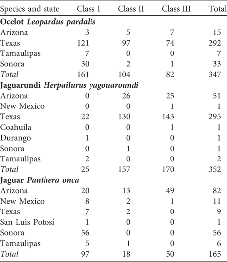
The historic range of all three species was well covered by participant knowledge (Fig. 1) but there was more knowledge about jaguar (n = 14) than ocelot (n = 9) or jaguarundi (n = 8). The densest coverage was for jaguars in south-east Arizona, where six participants had specific expertise. A total of 283 Class 1 Sightings with latitude and longitude were gathered (Table 1). There were fewer sightings for jaguar (n = 97) than for ocelot (n = 161), while the elusive jaguarundi was seen least (n = 25). Class 1 sightings were weighted towards the USA, particularly for the ocelot and jaguarundi (77% for ocelot, 88% for jaguarundi, and 36% for jaguar). Texas accounted for 69% of all sightings.
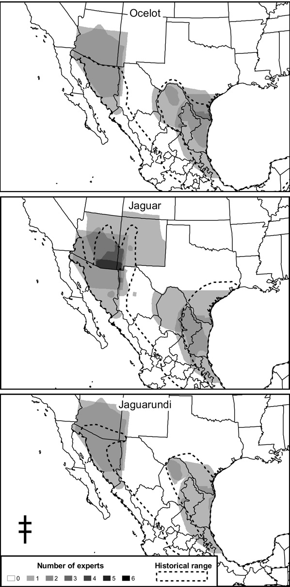
Fig. 1 Spatial coverage of participants' knowledge across the historical range of each of the three Neotropical felid species in the southern United States and northern Mexico.
Table 1 Number of sightings by species and Class (see text for further details) for each state.
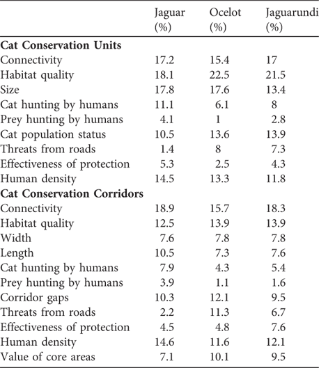
Various factors increased the integrity of Cat Conservation Units and Corridors. For Units, size, habitat quality, and connectivity were the most important factors whereas prey hunting by humans, threats from roads, and effectiveness of protection were the least important (Table 2). For Corridors, connectivity was the most important, and prey hunting by humans (for ocelots and jaguarundis) and threats from roads (for jaguars) were the least important.
Table 2 Percentage ranking of Cat Conservation Unit and Cat Conservation Corridor factors by workshop participants (see text for further details).
Twenty-one Units were identified, totalling 265,790 km2 of viable habitat, 14 of which were in Mexico. There were also 12 Units identified as Study Areas (Figs 1–2). All but one Study Area (for jaguar in the western bioregion) was within 100 km of the international border. The protected area analysis illustrated that areas identified as Units were largely unprotected (Table 3). An average of 8.9% of the Units have some level of protection. Most of this protected land (86%) is represented by jaguar Units on the USA side of the western bioregion. Furthermore 67% of protected areas within Units are category VI, the lowest level of protection. Other than jaguar Units in the western bioregion, only 2% of the Units have protection.
Table 3 Total area of Cat Conservation Units (Figs 2–3) for each felid species in each bioregion, area currently protected in each IUCN category (WDPA, 2008), total area protected, and total protected area as a percentage of total area.
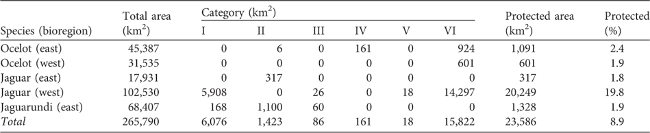
Seven Corridors were identified totalling 11,452 km2. None of these connect Units on opposite sides of the international border. Twelve Corridor Study Areas were identified, 50% of which connect areas across the international border. Only one Corridor currently has any protection: Sierra Madre–Sierra Picachos, with 128 km2 protected by Cumbres de Monterrey National Park and totaling 1.1% of all Corridor area. No Corridors were identified for jaguarundi because of lack of data.
Ocelots
The eastern bioregion for ocelots consists of 10 Units (45,387 km2) and three Corridors. There were also four Units and seven Corridors identified as Study Areas (Fig. 2) centred along the international border. These areas most likely connect breeding ocelot populations in the Sierra Madre and Gulf Coast regions to the Laguna Atascosa region in Texas. Little is known about ocelots in the western bioregion and no Corridors were identified there. Only one Unit was identified, running along the Sierra Madre Occidental in Mexico (31,535 km2; Fig. 2).

Fig. 2 Cat Conservation Units (CCUs) and Cat Conservation Corridors (CCCs) for ocelot (western and eastern bioregions) and jaguar (western and eastern bioregions). Units and Corridors are ranked by level of importance. JC-R1, LL-R4, and AB-1 are names given to Units during the mapping workshop.
Of the 11 Units delineated in both regions, four were ranked as very high priority: Sierra Madre (western bioregion) and Muzquiz, Laguna Catau, and Sierra de Tamaulipas (eastern bioregion), followed by four high priority Units located in the eastern region: Sierra Madre Oriental, Laguna Atascosa, Hidalgo and La Gloria (Fig. 2). Among them, La Gloria was determined to be especially important because it encompasses the majority of dense brushland in Starr County and the Rio Grande ecosystem.
In the eastern bioregion, two Corridors running between Sierra Tamaulipas and the Gulf Coast Corridor, and the Arroyo Los Olmos Corridor (connecting La Gloria Unit with the Rio Grande Study Area) were ranked as very high priorities (Fig. 2). Although Arroyo Los Olmos does not connect to another Unit, it was delineated based on observations of ocelots in the Rio Grande floodplain as they attempt to disperse through the Arroyo Los Olmos to establish territories in La Gloria area. Five areas (La Gloria, Laguna Madre, Laguna Atascosa, Lake Corpus Christi and Hidalgo) north of Brownsville, Texas were determined to require underpasses based on their history as highway mortality hot spots for ocelots (Fig. 2).
Jaguars
For jaguars in the eastern bioregion, four Units (17,931 km2) were identified along with three Corridors connecting them, on the Mexican side of the border (Fig. 2). In the eastern bioregion, no jaguar sightings have occurred on the USA side of the border in the last 50 years, and hence no Study Areas were delineated. Four Units were identified for jaguars in the western bioregion, two in the USA and two in Mexico. The two Mexican Units have a Corridor between them (Fig. 2). Otherwise, the connections between the Units are poorly understood and were determined to require further investigation. Specifically, the area between the Sierra Madre North and the Sky Islands needs to be studied to identify how jaguars are dispersing north from breeding populations in the Sierra Madre. Approximately 34% of the two USA Units are protected by a suite of Wilderness Areas and National Forests.
Of the eight Units delineated in both regions, three were ranked as very high priority: the Sierra Madre North and the Sky Islands Units in the west, and the Sierra de Tamaulipas Unit in the east (Fig. 2). The Sky Islands Unit has a particularly high level of protection; however, the status of jaguars there is uncertain. The Sierra de Tamaulipas range has no protection and the Sierra Madre North has < 3% protection. Two Units were ranked as high priority: Sierra Madre in the east and Mogollon Rim in the west. These Units deserve conservation attention in the near future (Fig. 2).
Four Corridors were identified for jaguars in both regions. Only the eastern bioregion has functional Corridors that connected all Units and where no areas require further study (Fig. 2). In the eastern bioregion the Sierra Madre to the Sierra Picachos Corridor was ranked as very high priority, and the Sierra de Tamaulipas-Sierra Maratinez and Sierra Madre-Sierra de Tamaulipas Corridors as high priority (Fig. 2). Because of existing habitat connectivity this bioregion appears to have greater integrity. However, only a fraction of the lands providing this connectivity have any type of protection.
For the western bioregion the Corridor connecting the Sierra Madre North to Sierra Madre South was designated a very high priority, although it currently has no protection (Fig. 2). This was the only Corridor identified for this region. Two underpasses were identified as being needed in northern Sonora, where jaguars are believed to be crossing roads as they disperse north (Fig. 2).
Jaguarundis
Two large contiguous Units (68,407 km2) were identified for jaguarundi in the eastern bioregion (Fig. 3): Nuevo León-Tamaulipas Plateau (very high priority habitat area) and South Tamaulipas-Coastal Veracruz (high priority habitat area). There were also two Study Areas identified on either side of the border, east of Big Bend National Park, Texas (Fig. 3). In the western bioregion no habitat areas were designated for jaguarundis due to an extreme lack of information about the species.

Fig. 3 Cat Conservation Units (CCUs) for jaguarundi (eastern bioregion). No habitat areas were delineated for the western bioregion because of lack of data. Units are ranked by level of importance.
Discussion
Protection of peripheral populations is an important aspect of the conservation of many species. Studies have illustrated that when species become rare they often persist in the periphery of their historic geographical ranges more so than elsewhere (Burbidge & McKenzie, Reference Burbidge and McKenzie1989; Channell & Lomolino, Reference Channell and Lomolino2000). Furthermore, climate change predictions advocate the protection and restoration of potential habitat to the north of current range limits and even north of the historic range. Current models predict that northern Mexico will suffer a high species turnover and disruption of ecosystems under certain climate change scenarios (Peterson et al., Reference Peterson, Ortega-Huerta, Bartley, Sanchez-Cordero, Soberon, Buddemeier and Stockwell2002). Conservation of peripheral populations also plays a role in maintaining the total genetic heterozygosity of a species (Young & Clarke, Reference Young and Clarke2000).
The USA-Mexico border region is a major hotspot for biodiversity, species richness, endemic and threatened species, and peripheral populations (Ceballos, Reference Ceballos1997; Ceballos et al., Reference Ceballos, List, Pacheco, Manzano-Fischer, Santos, Royo, Cartron, Ceballos and Felger2005). Local populations of more widely distributed species are often essential to maintaining the structure and function of regional ecosystems (Daily, Reference Daily1997; Terborgh et al., Reference Terborgh, Lopez, Nunez, Rao, Shahabudin and Orihuela2002). Also, because cats have large home ranges they are often considered umbrella species, an important concept in conservation biology, as protected areas designed for umbrella species have been able to afford sufficient protection to sympatric species over time (Lambeck, Reference Lambeck1997; Caro, Reference Caro2004; but see Seddon & Leech, Reference Seddon and Leech2008). If Neotropical cats are used as umbrella species (Foreman et al., Reference Foreman, Dugelby, Humphrey, Howard and Hodsworth2000a), protecting Cat Conservation Unit and Corridor areas could protect sympatric species whilst further studies are conducted to refine knowledge of the region's biodiversity.
The results of this study complement previous range-wide expert workshops on jaguars (Medellín et al., Reference Medellín, Equihua, Chetkiewicz, Crawshaw, Rabinowitz and Redford2002; Sanderson et al., Reference Sanderson, Redford, Chetkiewicz, Medellín, Rabinowitz, Robinson and Taber2002; Marieb, Reference Marieb2006) by providing finer detail about conservation priorities at a local scale and identifying new priority areas for the region. There are two major outcomes of this analysis. The first is the lack of protection associated with areas identified as Units and Corridors. Because land development and conversion in the border region are the primary threats to all three species, there needs to be greater protection of important habitat areas and dispersal corridors to ensure long-term viability of these populations. Although there is more nominal protection for Units (8.9%) than Corridors (1.1%), both lack protection beyond south-east Arizona and south-west New Mexico. This region is especially critical for the recovery of the jaguar in the south-western USA, as probably the source population is in central Sonora. To reach the USA jaguars need to travel through Sonora and Chihuahua, across unprotected areas where mortality is high and where continued expansion of the border fence will be another obstacle (Brown & López-González, Reference Brown and López-González2001; List, Reference List, Córdova and de la Parra2007).
Given that there are fewer protected areas in northern Mexico than in the USA, the Units and Corridors identified here represent an opportunity to expand land protection. These efforts, if coupled with information from other species or areas, such as the Terrestrial Priority Regions identified by CONABIO (CONABIO, 1998), could be used to promote protection of areas of overlap.
Perhaps most importantly the effective protection of both Units and Corridors justifies the creation of transboundary protected areas to maintain the high biodiversity of the border region, defined here as a transition zone of three of North America's ecoregions (Ceballos, Reference Ceballos1997; Bailey, Reference Bailey1998). The importance of transboundary conservation is important for felids and other rare species. For example, areas devoid of black bears in western Texas were recolonized by protected bear populations from the Serranias del Burro in Coahuila (Medellín et al., Reference Medellín, Manterola, Valdéz, Hewitt, Doan-Crider, Fulbright, Cartron, Ceballos and Felger2005). Other threatened species whose recovery on one side of the border depends upon the protection of adjacent areas in the neighbouring country include the black-tailed prairie dog Cynomys ludovicianus, bighorn sheep Ovis canadensis, pronghorn antelope Antilocapra americana and bison Bison bison (Ceballos et al., Reference Ceballos, List, Pacheco, Manzano-Fischer, Santos, Royo, Cartron, Ceballos and Felger2005; Medellín et al., Reference Medellín, Manterola, Valdéz, Hewitt, Doan-Crider, Fulbright, Cartron, Ceballos and Felger2005; Pelz-Serrano et al., 2006). However, the historically open border is now threatened by a border fence being constructed between the USA and Mexico that will prevent north and south movements of felids and other medium to large mammals (List, Reference List, Córdova and de la Parra2007).
Some of the Units and Corridors identified in this study overlap with areas where land protection efforts are underway, such as the proposed Janos Biosphere Reserve in Chihuahua (SEMARNAT, 2006) and the Cuenca Los Ojos project in Sonora (Cuenca Los Ojos, Reference Cuenca2008). Further north, the border fence has already obstructed some of the Units and Corridors proposed during this study (Eilperin, Reference Eilperin2008).
Another major outcome illustrated by this analysis is the need to obtain more information on the status of these three species of felid along the international border. Recent sightings of felids in the border region indicate they survive there but additional research is necessary in areas within 100 km of the border to understand better the ecological requirements and distributions of these three species. We believe it is this synthesis of knowledge on both sides of the border that is fundamental to the future protection of threatened and endemic fauna in this or any transnational region. As additional sightings continue to occur in the borderlands, and a new understanding emerges of its diverse inhabitants and their requirements for conservation, the Units and Corridors identified in this study will need to be revised. Only by doing so can we continue to make informed management decisions regarding these rare and cryptic species.
This mapping exercise also provided us with an opportunity to educate teachers and students in the border region. During the workshop teacher's guides and children's workbooks were developed and have recently been printed. These will be used to work with communities within high priority conservation areas. Both teachers and students will learn about the importance of conserving felids and other carnivores throughout the border lands. In the near future we plan to develop workbooks for private land owners in this region.
Acknowledgements
We wish to thank the Cat Action Treasury of the IUCN Cat Specialist Group, Defenders of Wildlife, the Howard Gilman Foundation, the Summerlee Foundation, the US Fish and Wildlife Service, the Wildlife Conservation Network, and WWF for financial and logistical support. We especially thank Charles Knowles, John Lucas and the staff at White Oak Plantation for hosting the mapping workshop. We thank Diana Lawhorn for development of the cat sightings database, Eric Sanderson and Mike Tewes for exchange of ideas during initial stages, Sharon Wilcox and Elizabeth Murdock for coordinating the mapping workshop, and all workshop participants who are not co-authors, including Allyson Atkins, Steve Bless, Manuel Bujanda Rico, Arturo Caso, Lee Elliot, Gabriela Gomez-Rodriguez, David Hodges, Elaine Iverson, Scotty Johnson, Ken Kaemmerer, Linda Laack, Patricia Manzano-Fischer, Stacy McReynolds, Aletris Neils, India Sanjuan and Lisa Williams. We thank Dr Reed Noss for a critical review of the manuscript. In particular, we thank Dave Foreman for his invaluable participation in the Bordercats Working Group, inspiring ideas, and unwavering motivation to conserve America's carnivores.
Biographical sketches
This study was one of the projects of the Bordercats Working Group (http://www.bordercats.org), which is part of the IUCN/Species Survival Commission's Cat Specialist Group. Participants in this mapping exercise had worked closely with the Bordercats Working Group for many years prior to the workshop and were all concerned about the status of border cats throughout their historic range. The land managers, scientists, and conservationists who participated in this study have dedicated a large portion of their careers to conserving biodiversity in the border region. This mapping exercise resulted from a shared belief that cats, as top predators, are a fundamental component of border ecosystems, border cat conservation is critical, present recovery plans and efforts are often inadequate for cat recovery, and threats to their survival are persistent.


