


INTRODUCTION
The term “site” is applied to a broad range of archaeological occurrences, from limited artifact surface scatters to thick stratified anthropogenic accumulations (Bar-Yosef and Goren, Reference Bar-Yosef and Goren1980). One of the confounding factors underlying the undiscriminating use of the term is the effects of post-depositional processes, which often blur distinctions between single events and multiple recurrences of archaeological deposition and accumulations. In open-air sites (OAS), such processes take place at diverse scales—from microscopic local disturbances to large-extent landscape processes.
Because OAS lack physical boundaries, they may present ‘lateral stratigraphies,’ in which sequential occupations are located side-by-side rather than in vertical sequences. In such cases, the temporal relationship between the remains of the occupations may be difficult to reconstruct. Given this combination of reasons, open-air anthropogenic accumulations of material culture often are perceived as partial, distorted, and potentially time-averaged archaeological records, where the effects of underlying anthropogenic versus geogenic factors are difficult to pry apart. Surface artifact scatters are treated with special caution, given that they may represent either remains of in situ occupations, or of deflated in situ occupations, or are entirely post-depositional scatters caused by geomorphic processes. Therefore, many researchers have viewed surface Paleolithic materials as less reliable, and therefore less informative, archaeological archives compared with sheltered or in situ OA sites, arguably to the degree that their investigation may lead to fallacious interpretations of long-term cultural processes (e.g., Coco and Iovita, Reference Coco and Iovita2020; Coco et al., Reference Coco, Holdaway and Iovita2020; but see Holdaway and Davies, Reference Holdaway and Davies2019; Douglass et al., Reference Douglass, Wandsnider and Holdaway2023).
Researchers have attempted to evaluate the scientific value of archaeological data extracted from OAS, focusing on the formation of palimpsests and possible ways to disentangle them at evolutionary and anthropological time scales, by using various types of empirical archaeological and geological data to discriminate between human and natural agents (see for example: Stern, Reference Stern1994; Bailey, Reference Bailey2007; Malinsky-Buller et al., Reference Malinsky-Buller, Hovers and Marder2011; Vaquero et al., Reference Vaquero, Chacón, García-Antón, Soler, de, Martínez and Cuartero2012; Hovers et al., Reference Hovers, Ekshtain, Greenbaum, Malinsky-Buller, Nir and Yeshurun2014, and references therein). Several problems inherent to the use of surface assemblages in Paleolithic research can be overcome by combining refitting analysis and attribute analysis, which focus on lithic technology (Chiotti et al., Reference Chiotti, Olszewski, Dibble, McPherron, Schurmans, Smith, Hawass and Richards2007, Reference Chiotti, Dibble, Olszewski, McPherron and Schurmans2009), and by relying on landscape-scale geomorphology and site-scale sedimentology (Thompson et al., Reference Thompson, Mackay, De Moor and Gomani-Chindebvu2014; Wright et al., Reference Wright, Thompson, Schilt, Cohen, Choi, Mercader and Nightingale2017; Burrough et al., Reference Burrough, Thomas, Allin, Coulson, Mothulatshipi, Nash and Staurset2022).
Archaeological thinking about site integrity in arid zones has been especially concerned with landscape stability and with the possible outcomes of prolonged exposure of surface archaeological remains to climate-driven geomorphic processes that control landscape evolution (e.g., Cancellieri and di Lernia, Reference Cancellieri and di Lernia2013). Arid zone surface sites may be highly resilient and preserve high-integrity archaeological signatures where the landscape is stable and relatively uninterrupted biologically or geomorphologically. Such sites, however, may also be prone to winnowing. On the other hand, some arid zone sites, especially those located along highly inclined slopes, may suffer from high erosion rates. Researchers focused their attempts on potential ways to discern single events of human activity (Hallinan and Shaw, Reference Hallinan and Shaw2015) and assess their preservation (Cziesla, Reference Cziesla, Cziesla, Eickhoff, Arts and Winter1990a, Reference Cziesla, Cziesla, Eickhoff, Arts and Winterb) in order to quantify human presence and its effect on desert landforms and desert pavements (Foley, Reference Foley, Hodder, Isaac and Hammond1981; Foley and Lahr, Reference Foley and Lahr2015). Another research focus has been to extract archaeological information at large geographical scales in geomorphologically dynamic areas where landscape evolution caused erosion and artifact movements at a number of spatial scales (e.g., Goldberg and Brimer, Reference Goldberg, Brimer and Marks1983; Olszewski et al., Reference Olszewski, Dibble, McPherron, Schurmans, Chiotti and Smith2010; Groucutt et al., Reference Groucutt, Scerri, Amor, Shipton, Jennings, Parton, Clark-Balzan, Alsharekh and Petraglia2017; Wright et al., Reference Wright, Thompson, Schilt, Cohen, Choi, Mercader and Nightingale2017; Hardaker, Reference Hardaker2020).
In this study we consider the potential archaeological merits of OAS in arid zones. Based on empirical data from the extensive research history in the Negev desert region in southern Israel, we combine archaeological and geomorphological methods to build a conceptual model of multi-scale effects on the archaeological remains. We show that integration of methodologies from both disciplines provides nuanced insights to our understanding of the archaeological record. By integrating the archaeological and geomorphic data sets in a multi-scale analytical approach, archaeologists may gain better options of interpreting regional effects on human evolution while the artifactual contexts provide high-resolution controls for site-specific geomorphic processes. Such insights then can be incorporated into syntheses and behavioral models on a regional scale.
We present a ‘proof-of-concept’ study for assessing the feasibility of the model suggested here for future study of OAS. Specifically, we apply the approach to three OAS in the central and northern Negev desert of Israel: Nahal Aqev (unit 7) (henceforth Nahal Aqev), Nahal Yitnan 7, and Giv'at Barne'a. All three OAS are placed within the chronological framework of the Middle Paleolithic (MP) period, yet under three different depositional scenarios. Our multi-scale approach allows us to assess the integrity of the three sites as sources of archaeological data and compare them, relying on geomorphic conditions supported by a plethora of geomorphic and Quaternary studies of the Negev to interpret the target sites (see Enzel et al., Reference Enzel, Amit, Dayan, Crouvi, Kahana, Ziv and Sharon2008; Enzel and Bar-Yosef, Reference Enzel and Bar-Yosef2017). Our investigation focuses on the degree and kind of lithic taphonomic modification (Hiscock, Reference Hiscock1985) in relation to variable temporal and spatial scales of landscape processes.
GEOLOGY AND QUATERNARY GEOMORPHIC EVOLUTION OF THE STUDY REGION
The studied sites are situated along a southwest-northeast transect that parallels the northwestern fringes of the Levantine-Syrian Arc fold structures of the northern and central Negev (Fig. 1). The Syrian Arc includes a series of parallel northeast-trending monoclines and synclines exposing limestone, dolomite, chalk, and flint of Upper Cretaceous to Tertiary age. Folding initiated during the late Turonian and continued to the early Eocene (Eyal and Reches, Reference Eyal and Reches1983). During the Eocene, thick carbonaceous sediments were deposited in the synclines, forming the sub-horizontal carbonate strata of the Avedat Group in the Avedat Plateau and the hills surrounding the Beer-Sheva valley. The sediments of Early Miocene fluvial conglomerates and sandstones of the Hazeva Formation (Calvo and Bartov, Reference Calvo and Bartov2001) were deposited on the Oligocene surface of the central and northern Negev, truncating the ridge crests and the top of the geological section deposited in the synclines of the Syrian Arc structures (Avni et al., Reference Avni, Segev and Ginat2012).

Figure 1. (a) Map of the Negev desert showing the 3 studied open-air sites and other MP sites in the region. (b) Soils and rainfall map (after Amit et al., Reference Amit, Simhai, Ayalon, Enzel, Matmon, Crouvi, Porat and McDonald2011) with sample sites (in red).
The present elevation of the region has been controlled by differential uplift since the Middle Miocene, influenced by Dead Sea rifting that generated a general uplift of its flanks (Avni, Reference Avni, Enzel and Bar-Yosef2017). This tectonic uplift, which ceased during the late Early Pleistocene (ca. 1 Ma), determined the two main ephemeral channel systems currently in the Negev desert area: one flowing towards the Mediterranean Sea in the northwest and the other into the Dead Sea Rift in the east.
The drainage basins of the central and northern Negev were shaped by phases of fluvial incision and aggradation during the Pliocene and the Pleistocene (Avni et al., Reference Avni, Faershtein, Porat, Enzel and Bar-Yosef2017; Matmon and Zilberman, Reference Matmon, Zilberman, Enzel and Bar-Yosef2017). Simultaneously, fluvial, aeolian, weathering, and soil-formation processes were active and shaped the present-day landscape. These include bedrock weathering (Yair, Reference Yair1983; Wieler et al., Reference Wieler, Gini, Gillor and Angel2021), cycles of loess deposition, erosion and redeposition, differential slope runoff generation (Wieler et al., Reference Wieler, Avni and Rosensaft2016), fluvial incision and deposition, calcrete formation (Vogel and Geyh, Reference Vogel and Geyh2008) and the formation of Reg soils through incorporation of dust and salt into the clastic sediments, clast shattering, and surface patination. Several fluvial terraces, dated to the last 0.5 Ma, have developed as a result of incision and episodic deposition of fluvial sediments, mainly controlled by climatic fluctuations (Goldberg, Reference Goldberg and Marks1976, Reference Goldberg1986; Porat et al., Reference Porat, Amit, Enzel, Zilberman, Avni, Ginat and Gluck2010; Matmon et al., Reference Matmon, Elfassi, Hidy, Geller, Porat and Team2016; Avni et al., Reference Avni, Faershtein, Porat, Enzel and Bar-Yosef2017, Reference Avni, Oron, Cohen-Sasson, Porat and Barzilai2021). These terraces are mapped and named from the older group of terraces (Q1), deposited during the Middle Pleistocene, to the youngest (Q3) terrace, deposited during the Late Pleistocene glacial phase (Avni and Wieler, Reference Avni and Wieler2013; Avni et al., Reference Avni, Faershtein, Porat, Enzel and Bar-Yosef2017, Reference Avni, Oron, Cohen-Sasson, Porat and Barzilai2021). The sites under discussion fall within the Q2 depositional phases that covered the Middle–Late Pleistocene transition.
Soil and sediments of the central and northern Negev, which comprise the main substrate for prehistoric sites, are dominated by primary and secondary loess deposits. Primary loess deposits, several meters thick, which originated as desert dust (Yaalon and Dan, Reference Yaalon and Dan1974), blanketed the highlands and valleys of the central and northern Negev during the Middle and Late Pleistocene (Bruins and Yaalon, Reference Bruins, Yaalon and Pesci1980; Pye and Tsoar, Reference Pye and Tsoar1987; Crouvi et al., Reference Crouvi, Amit, Enzel, Porat and Sandler2008, Reference Crouvi, Amit, Porat, Gillespie, McDonald and Enzel2009; Avni et al., Reference Avni, Oron, Cohen-Sasson, Porat and Barzilai2021). Most of the currently preserved loess cover in the Negev accumulated during the last major event of loess deposition, dated to ca. 70–20 ka, corresponding to the last glacial period (MIS 4–2) (Crouvi et al., Reference Crouvi, Amit, Enzel, Porat and Sandler2008), with the most intense accumulation taking place ca. 40–20 ka. Substantial older loess deposits were eroded during MIS 5 (Lucke et al., Reference Lucke, Roskin, Vanselow, Bruins, Abu-Jaber, Deckers and Lindauer2019; Avni et al., Reference Avni, Oron, Cohen-Sasson, Porat and Barzilai2021). Remains of earlier loess deposits, predating MIS 4, were preserved as relatively small-scale relicts in hilltop deposits (Crouvi et al., Reference Crouvi, Amit, Enzel, Porat and Sandler2008, Reference Crouvi, Amit, Porat, Gillespie, McDonald and Enzel2009) and within fluvial terraces deposited along the upper parts of main drainage basins of the central Negev highlands, such as in the upper Zin valley and the upper tributaries of Nahal (Wadi) Arod (Faershtein et al., Reference Faershtein, Porat, Avni and Matmon2016; Avni et al., Reference Avni, Oron, Cohen-Sasson, Porat and Barzilai2021). The fine, clay-size fraction of the loess cover in the Negev originates from distal sources in the Sahara Desert, while the coarser, silt-sized grains are winnowed (Roskin et al., Reference Roskin, Katra, Agha, Goring-Morris, Porat and Barzilai2014) and possibly abraded (Crouvi et al., Reference Crouvi, Amit, Enzel, Porat and Sandler2008) from relatively proximal sources, namely the Nile Delta and Sinai-Negev erg (Ben-Israel et al., Reference Ben-Israel, Enzel, Amit and Erel2015; Roskin and Tsoar, Reference Roskin, Tsoar, Enzel and Bar-Yosef2017).
Primary loess was eroded from the slopes and redeposited along the Negev highland valleys as alluvial and colluvial fills (Bowman et al., Reference Bowman, Karnieli, Issar and Bruins1986), that are up to ~20 m thick in the northern Negev plains (Zilberman, Reference Zilberman1991). Several paleosols with distinct carbonate-rich Bk horizons, evidence of cycles of deposition and pedogenesis, developed in the primary and secondary deposits (Zilberman, Reference Zilberman1991; Crouvi et al., Reference Crouvi, Amit, Porat, Gillespie, McDonald and Enzel2009; Robins et al., Reference Robins, Greenbaum, Yu, Bookman and Roskin2021).
Altogether, the loess deposits were pivotal components in the long- and short-term soil formation as well as slope and fluvial sedimentological processes. Most of the soils in the study region, such as calcic Loessial Serozems (Calciorthids) and Reg soils (Dan and Raz, Reference Dan and Raz1970), are comprised of substantial amounts of aeolian or reworked loess that form an important component of the soils. Archaeological deposits have been affected by these processes and may serve as markers for determining accumulation, fixation, and erosion rates (Lucke and Bäumler, Reference Lucke and Bäumler2021).
THE SITES
To construct a simple model with explicit parameters, we selected three sites—Nahal Aqev, Nahal Yitnan 7, and Giv'at Barne'a (Fig. 1a)—as examples for distinctly different depositional scenarios of lithic artifacts on the open landscape. We acknowledge that these are not the only possible scenarios of site formation histories. Still, for the purposes of the present research we chose to focus on these discrete case studies for clarity's sake. The three sites are all situated in a zone that today corresponds to an arid climate receiving an average of 75–100 mm annual precipitation (Fig. 1b; Amit et al., Reference Amit, Simhai, Ayalon, Enzel, Matmon, Crouvi, Porat and McDonald2011). Each site is situated within the upper reaches of a major drainage basin (Nahal Zin, Nahal Besor, and Wadi Al-Arish, respectively) of the central-northern Negev and the northern Sinai Peninsula. Floods in main ephemeral watercourses occur 1–3 times a year, with some of the large floods lasting for 1–2 days. Flood duration averages seven days per annum (Alexandrov et al., Reference Alexandrov, Laronne and Reid2003).
Accumulation histories are analyzed and explained in the Results section. We note here that our field observations, archaeological, geomorphic, and sedimentological analyses suggest that each site has undergone distinct landscape evolution processes, therefore each assemblage represents a different accumulation scenario in terms of its nature and duration.
The three sites were subject to analyses on three different scales: (1) the regional scale, where each site was placed in the context of the large geological and geomorphic processes that controlled landscape evolution in the Negev; (2) the site-specific scale of formation processes; and (3) assemblage-scale flint taphonomy. Importantly, the main raw material in all three assemblages is flint extracted from geological formations of Eocene age (Broun, Reference Braun1967; Benjamini, Reference Benjamini1979), exposed in immediate proximity to each of the sites. This reduces (albeit does not remove) the likelihood that lithic taphonomic characteristics are dictated by raw material differences.
Nahal Aqev
Nahal Aqev is an in situ archaeological assemblage that was sealed by sediment shorty after its accumulation; therefore, it has been subjected to a single process—continuous burial in an active fluvial-colluvial wadi terrace. The archaeological site was initially excavated in the 1970s (Munday, Reference Munday and Marks1977). During re-excavations in 2015–2016, several archaeological horizons were exposed below the formerly excavated ones. Of these newly excavated horizons, we analyzed unit 7, which is well confined stratigraphically and dated by luminescence methods (Barzilai et al., Reference Barzilai, Oron, Porat, White, Timms, Blockley and Zular2022).
Nahal Yitnan 7
Nahal Yitnan 7 is an assemblage with a complex history of episodic burial by loess sediments and pedogenesis, and partial exposure on the surface mainly due to slope processes. The assemblage was retrieved from a surface collection and from a shallow excavation of a horizon of a dense scatter of flaked flint with maximum depth of 30 cm below the eroded modern surface (Yegorov, Reference Yegorov2017).
Giv'at Barne'a
Giv'at Barne'a is a flint quarry and knapping site adjacent to a flint outcrop, at the top of a bedrock-dominated hill. Here, artifacts exposed on the surface and associated by typo-technological traits to several periods from the MP to Holocene, were collected and mapped.
HYPOTHESES
Given the geomorphic history of the study region, we posit that (1) the stratigraphic location of sites in relation to the regional loess cover is chronologically informative and enables their allocation to the time span of MIS 4–2 or to earlier or later time periods (we would thus expect that dates of sites embedded in loess sequences will fall within this time range); (2) the local geomorphic processes at each site are informative about cycles of deposition and erosion within the main periods of loess cover (this information in turn may be useful in creating a more accurate and nuanced geomorphic history); (3) taphonomic effects in lithics, as known from the literature (see Methods section and Supplementary data 4), may be linked to anthropogenic activities or/and to environmental processes (i.e., if the sources of taphonomic modifications are understood, they can be informative about broader scale processes in the geomorphic record). We use this information as a means to build a model of site preservation integrity that can be used to create an informed reconstruction of human settlement, activity, and movement across the region. However, a detailed discussion of the latter is outside the scope of this paper.
MATERIALS AND METHODS
Geomorphic field and laboratory methods
Stratigraphic sections at the local site scale were described by conventional geological and sedimentological field methods and placed within the regional stratigraphic scheme provided by 1:200,000 and 1:50,000 geological maps of the Geological Survey of Israel (Roded, Reference Roded1996; Zilberman and Avni, Reference Zilberman and Avni2005; Wdowinski et al., Reference Wdowinski, Sneh and Avni2012; Avni and Wieler, Reference Avni and Wieler2013). In addition, field surveys and recent Google Earth imagery were used for complimentary data on the study sites.
Samples were sieved to finer than 2 mm and analyzed for particle size distribution (PSD) with a Beckman-Coulter LS grain-size analyzer (Fraunhofer.rf780d diffraction). A representative aliquot of ~2 ml subsample was treated to dissolve carbonates and disperse fines. Total inorganic carbon (IC) was measured with a Primacs SLC TOC Analyzer. Munsell color was determined in the laboratory on dry samples.
Samples for optically stimulated luminescence (OSL) dating were collected at each site from excavated sediment sections related to the archaeological finds. The sediments were mostly loess and loess derivatives (reworked, mixed with gravel, or with additional local carbonates). The dated very fine-grained quartz sand (90–125 μm) grains originated from distal loess sources and are presumed to have been well bleached at the time of deposition (see Supplementary data 2 for sampling preparation and analytical protocols).
OSL dating followed protocols after Faershtein et al. (Reference Faershtein, Porat, Avni and Matmon2016). Equivalent doses (De) were measured on the purified quartz using the OSL signal and the single aliquot regenerative dose (SAR) protocol (Murray and Wintle, Reference Murray and Wintle2000). Eighteen to 34 aliquots (2 mm) were measured for each sample, and the average De and errors were calculated using the central age model (CAM; Galbraith and Roberts, Reference Galbraith and Roberts2012). Dose rates were calculated from concentrations of the radioactive elements U, Th, and K, measured on the additional sample by ICP-MS (U & Th) or ICP-OES (K). Moisture contents were estimated at 5 ± 3%, as appropriate for this arid to hyperarid region, and the cosmic dose was evaluated from current burial depths.
Lithic taphonomy
The lithic samples
From the perspective of lithic technology, MP assemblages from southern Levantine sites conform to a general classification of Levantine Mousterian—characterized by the conspicuous appearance of Levallois technology (Bar-Yosef, Reference Bar-Yosef, Hovers and Kuhn2006), which is absent or very rare in previous or successive periods in the Levant (Goren-Inbar, Reference Goren-Inbar2011; Malinsky-Buller, Reference Malinsky-Buller2016; Goder-Goldberger, Reference Goder-Goldberger, Leplongeon, Goder-Goldberger and Pleurdeau2020; Zaidner and Weinstein-Evron, Reference Zaidner and Weinstein-Evron2020). Procedures of the Levallois knapping system resulted in several indicative artifact categories such as Levallois cores, Levallois target items (points, flakes, and blades), and specific core trimming elements (Boëda, Reference Boëda, Dibble and Bar-Yosef1995). Since Levallois technology is diagnostic of MP knapping and produces some technologically indicative artifacts, we analyzed Levallois items from each site, assuming they fall within the MP even if no absolute dating was available. Hence, samples for lithic taphonomic analysis included all artifacts from Nahal Aqev and all Levallois cores and products from the other two assemblages. In Nahal Yitnan 7 the samples include all Levallois products excavated and collected (4.2% of the total assemblage); for Giv'at Barne'a, only a sample (~40% of all artifacts) was counted to techno-typological groups. All Levallois cores and products were analyzed (3% of the counted assemblage).
Taphonomic attributes
There does not appear to be any clear linear timeline for formation of the damages impacting flint items (Burroni et al., Reference Burroni, Donahue, Pollard and Mussi2002). While the intensity of alteration cannot be used as a relative chronological marker, types of impact can serve as indicators of assemblage history and accumulation processes. By contextualizing lithic taphonomic attribute states (e.g., states of breakage, surface alteration), we explored their use as meaningful tools for back-tracking natural processes that affected a site. A sample from each site (see above) was subjected to an attribute analysis focusing on taphonomic variables. The analysis was carried out by simple naked eye observations. After quantification of the results, taphonomic attributes were used for understanding each assemblage in the context of its accumulation history, as well as part of an inter-site comparison.
We focused on five variables (see Supplementary data 4 for further information about known causes of each taphonomic condition and examples).
Item breakage. Unintentional artifact breakage may occur due to rolling and saltation as coarse bedload during flood events, trampling by both anthropogenic and non-anthropogenic agents, and sediment compaction after coverage (McBrearty et al., Reference McBrearty, Bishop, Plummer, Dewar and Conard1998; Burroni et al., Reference Burroni, Donahue, Pollard and Mussi2002; Hovers, Reference Hovers, Martínez-Moreno, Torcal and de la Torre Sainz2003; Eren et al., Reference Eren, Durant, Neudorf, Haslam, Shipton, Bora, Korisettar and Petraglia2010, Reference Eren, Boehm, Morgan, Anderson and Andrews2011; Jennings, Reference Jennings2011). For our analysis, items were categorized as broken or complete.
General surface abrasion and edge damage. Small fractures and the general roughness of an artifact's lateral edges and the ridges on its flaked surfaces are related to mechanical movement in fluvial processes (Dibble et al., Reference Dibble, Chase, McPherron and Tuffreau1997; Burroni et al., Reference Burroni, Donahue, Pollard and Mussi2002; Grosman et al., Reference Grosman, Sharon, Goldman-Neuman, Smikt and Smilansky2011; Hovers et al., Reference Hovers, Ekshtain, Greenbaum, Malinsky-Buller, Nir and Yeshurun2014; Bustos-Pérez et al., Reference Bustos-Pérez, Díaz and Baena2019). The degrees of surface and ridge abrasion (fresh, partly abraded, and highly abraded) and of the item's edge damage (none, minimal, significant, and high) were assessed and categorized based on visual inspection.
Patination. In geomorphological studies, the term patina encompasses a varied group of rock-surface alterations compared to its archaeological use (Caux et al., Reference Caux, Galland, Queffelec and Bordes2018) and includes surface gloss (which we discuss separately). Here, we adopt the archaeological usage, by which ‘patination’ refers to changes in the color of flint, related to surface alterations caused by sediment chemistry, flint microscopic structure, humidity, and exposure to sun/light (Hurst and Kelly, Reference Hurst and Kelly1961; Honea, Reference Honea1964; Rottländer, Reference Rottländer1975; Friedman et al., Reference Friedmann, Goren-Inbar, Rosenfeld, Marder and Burian1995; Howard, Reference Howard1999, Reference Howard2002; Burroni et al., Reference Burroni, Donahue, Pollard and Mussi2002). Items were categorized into three conditions related to patination: existence of patina (patinated, not patinated, double patinated), type of coloring identified (desert varnish, white patina, white stains, black/gray coloring), and the patinated face of the artifact (one or both surfaces of the item).
Gloss. Glossy surfaces on flint artifacts, smooth to the touch, are a result of chemical processes and, to a lesser degree, mechanical weathering (Howard, Reference Howard1999, Reference Howard2002; Burroni et al., Reference Burroni, Donahue, Pollard and Mussi2002). Items were categorized into three groups according to the degree of gloss apparent on the item surface (none, some, significant).
Pitting. Pitting refers to visible spherical pits in the size range from 2 mm to several cm in diameter that are created on artifact surfaces by thermal (often referred to as potlid scars/craters) and chemical processes and may cause the splitting and breakage of an artifact (Burroni et al., Reference Burroni, Donahue, Pollard and Mussi2002; Knight and Zerboni, Reference Knight and Zerboni2018, Yegorov et al., Reference Yegorov, Marder, Khalaily, Milevski and Rosen2020). For this analysis items were categorized to three groups according to the number of pits apparent on the item surface (none, some, significant).
Statistical analysis
Chi-square (χ2) tests were used to test meaningful patterning of taphonomy-related conditions within each assemblage (χ2 goodness of fit test) and for comparisons between them (χ2 test of independence). The correlations between each site to the others were checked further using an ordinal correlation test, expressing the similarities or dissimilarities between the distribution of attribute states between each pair of sites in numeric values between −1 and 1. The tests were calculated using Excel, following the χ2 formulas for the tests and using the excel data analysis correlation tool (see Supplementary data 5 for full information on the variables used and the calculations).
RESULTS
The results for each of the three studied sites are presented in this section, following the three analytical scales we employed.
Nahal Aqev
Geological and geomorphological settings
The site of Nahal Aqev is situated within the gorge/canyon of the Aqev wadi, part of the Zin drainage system in the central Negev Highlands (Figs. 1, 2). The wadi fill consists of gravels and redeposited loess organized as a series of fluviatile terraces, accompanied by lateral colluvial deposits situated along the transition zone between the cliffs and the valley bottom. These terraces, which are mapped as Q2 and Q3 terraces, correspond to the Middle Pleistocene and Late Pleistocene deposition phases (Avni and Wieler, Reference Avni and Wieler2013; Avni et al., Reference Avni, Faershtein, Porat, Enzel and Bar-Yosef2017, 2021).

Figure 2. The study area of Nahal Aqev. (a) Location of the site and the current Ein Aqev spring, situated 500 m downstream (view to north). (b) Old and new excavation areas and the geological trench (view to east). The full terrace section is 7 m deep. (c) Southern view of the geological units bearing archaeological horizons, color-shaded for clarity (Unit 7, light blue, 0.5 m scale bar placed on the section). (d) Geological map of the site's vicinity (Avni and Wieler, Reference Avni and Wieler2013).
Local context
The site is stratified within the abandoned colluvial body that corresponds with the Q2 terrace surface (Avni et al., Reference Avni, Oron, Cohen-Sasson, Porat and Barzilai2021), deposited at an elevation of 430 m above mean sea level (amsl) along the western bank of the Ein Aqev Canyon. Eighteen sedimentological units were identified in the terrace sequence, including three preserved archaeological horizons (Barzilai et al., Reference Barzilai, Oron, Porat, White, Timms, Blockley and Zular2022).
Unit 7 is 30 cm thick and contains abundant knapped flint items (Fig. 2c). Both field observations and technological analyses suggest that the lithic artifacts, horizontally embedded within the matrix, derive from an in situ horizon protected from subsequent erosion by rapid accumulation of fine-grained sediments within the Q2 terrace. There are no indications for sorting, and 60.5% of the retrieved items are <2 cm in size, which suggests minor post-depositional water disturbance (Schick, Reference Schick1984; Dibble et al., Reference Dibble, Chase, McPherron and Tuffreau1997). The abundance of refitted items also suggests rapid burial of the lithics after their initial deposition (Villa, Reference Villa1982; Dibble et al., Reference Dibble, Chase, McPherron and Tuffreau1997; Deschamps and Zilhão, Reference Deschamps and Zilhão2018; Bertran et al., Reference Bertran, Todisco, Bordes, Discamps and Vallin2019).
Unit 7 was dated to 131 ± 23 ka by the post-infrared signal of alkali feldspars, which is consistent with its placement on a Q2 surface (Avni et al., Reference Avni, Oron, Cohen-Sasson, Porat and Barzilai2021; Barzilai et al., Reference Barzilai, Oron, Porat, White, Timms, Blockley and Zular2022). The feldspars showed very little scatter in De values, indicating adequate bleaching of all grains prior to deposition.
Flint taphonomy
The lithic assemblage of unit 7 comprises 4133 artifacts, among which 1479 are larger than 2 cm and were subjected to a detailed attribute analysis, per practice for MP assemblages (Hovers, Reference Hovers2009). Of the latter, 23 are cores and 1456 are knapping products (debitage and tools, Table 1). A smaller sample (n = 224) was studied for gloss and pitting attributes. The taphonomic analysis did not reveal any significant differences between cores and flaking products (but note the small size of the core sample).
Table 1. Breakdown of flint taphonomy attributes for the three assemblages

Flint items from Nahal Aqev show minimal surface abrasion, with 98% (n = 1449) showing no abrasion and only 2% (n = 30) abraded. More than half of the items are broken (57%, n = 844). Edge damage is less frequent with 40% (n = 530) showing minimal damage, 4% (n = 51) having significant damage, and a single item with extensive edge damage. Most of items (71%, n = 158) do not show gloss; with relatively low frequencies of moderate (27%, n = 60) and significant (3%, n = 6) gloss.
None of the items in the sample shows surface pitting (this may be a result of the smaller sample studied). Only 17% of the items (n = 251) in the total sample show patina, among which the dominant types are white stains (39%, n = 98) and black-gray color (38%, n = 96). An additional 22% (n = 55) bear white patina and only 2% (n = 3) show brown patination. Out of the patinated items, 94% (n = 237) bear patina on both faces. Only two items show different colorings on different flaking scars. None of the artifacts shows differential patination of distinct artifact faces.
The χ2 tests for Nahal Aqev showed that the distribution is significantly different from the null hypothesis for all attributes (see Supplementary data 5 for test results). This suggests meaningful patterning of taphonomy-related conditions, which in turn can be linked to specific environmental conditions at the site.
Nahal Yitnan 7
Geological and geomorphological settings
The Nahal Yitnan 7 site is located at the northern part of a plateau of the Eocene Avedat Group rocks (Figs. 1, 3a, b). The plateau was probably overrun by fluvial deposits (sandstone and conglomerates) of the Early Miocene Hazeva Formation. The site is adjacent to the Nahal Yitnan basin, a tributary of Nahal Beersheva.

Figure 3. Nahal Yitnan 7 site. (a) Southeasterly view of the slope with artifact scatter (~50 m long) and trench location (~20 m between East and West trenches). The valley of Nahal Yitnan is in the background. (b) Geological map of the site's vicinity (Roded, Reference Roded1996; Wdowinski et al., Reference Wdowinski, Sneh and Avni2012). The site's location is marked by the black and red diamond (c) Developed calcrete exposed uphill from the MP flint scatter (d) Excavation area C where horizon 3 bearing the artifacts was excavated. (e) Section of the excavation in area B showing horizons 4 and 3 with highly calcic loess at the bottom, under the artifact-bearing layer. Scale in (c–e) = 1 m.
The Nahal Yitnan basin drains northwards along an ancient ~300-m-wide valley that runs along the contact between soft chalk rocks of the Avedat Group and the hard limestone and dolomite rocks of the Judea Group (Fig. 3a, b). The valley was initially infilled with both in-situ and reworked Hazeva Formation clasts. The region was overlain by thick late Quaternary loess deposits that have been significantly eroded.
Today, the area is heavily grazed and tilled by local Bedouins, hence natural vegetation cover is sparse. In the Late Pleistocene, the region was likely covered by shrubs that stabilized the surface and affected soil formation and slopewash dynamics (Kijowska-Strugała et al., Reference Kijowska-Strugała, Wiejaczka, Lekach and Bucała-Hrabia2017).
Local context
The Nahal Yitnan 7 site is located at an elevation of ~450 m amsl on a slope of eroded Eocene chalk that is partially topped by a 20–60 cm-thick calcrete pre-dating loess deposition. Lithic artifacts were both scattered on the surface and buried along and within the southeastern gentle (5–10°) slope of a hill within the drainage area of a first-order tributary of the ephemeral Nahal Yitnan. The surface of the middle and lower parts of the slope exposes a ~40% cover of weathered and angular, cobble-size chalk fragments, and rounded fluvial pebbles on a calcic Loessial Serozem soil (Fig. 3a). The upper part of the slope comprises a 0–50 cm thick reworked loess deposit. A first-order wadi that drains the hillslope to the south has a thicker loess infill (Dan et al., Reference Dan, Yaalon, Koyumdjiski and Raz1976; Yair and Enzel, Reference Yair, Enzel and Ahnert1987).
The artifacts at Nahal Yitnan 7, which were systematically collected and excavated in two areas: B and C (Fig. 3; Yegorov, Reference Yegorov2017), were assigned to the MP period on the basis of their typo-technological characteristics. To identify the spatial distribution of the artifacts and to see if they derived from buried assemblages, two ~1 m deep trenches (East trenches A and B, respectively; Figs. 4a, S1.2, S1.3) were dug along the slope of the hill. An additional trench (West trench, Figs. 4b, S1.4) was excavated in the first-order wadi. The artifact-bearing horizon was identified at different depths in all three trenches, where it was sampled for sediment analysis and OSL dating.
The trenches reveal distinct catenary changes in the stratigraphic sequence at the site (see Supplementary data 1 for full sedimentological analysis). Particle-size distribution of samples from most of the units shows a general pattern characteristic of primary loess (Crouvi et al., Reference Crouvi, Amit, Porat, Gillespie, McDonald and Enzel2009) in the region (see full data in Supplementary data 3), mixed through slope-wash processes with fine-grained sand originating from the underlying Hazeva Formation. The sediments are highly calcic (46–64%) and resemble incipient calcrete, which can precipitate rapidly during intervals of decreased dust (loess) deposition, with contribution from the underlying weathered and eroded chalk deposits.
Approximately 20 cm-thick units of knapped flint artifacts, with differential preservation states, were identified, mainly in the Bk horizons (Fig. 4; Tables S1.1–3). Some artifacts were found in vertical positions. The presence of artifact-bearing sedimentological units in all the trenches demonstrates that lithics were distributed over an area of several hundred square meters. The spatial distribution of lithics on the surface is in accordance with the finds of artifacts in the upper units of the trench sections. Erosion of the loess along with modern, 30-cm-deep tilling (see Fig. 3a) partially contributed to the exposure of the artifacts.
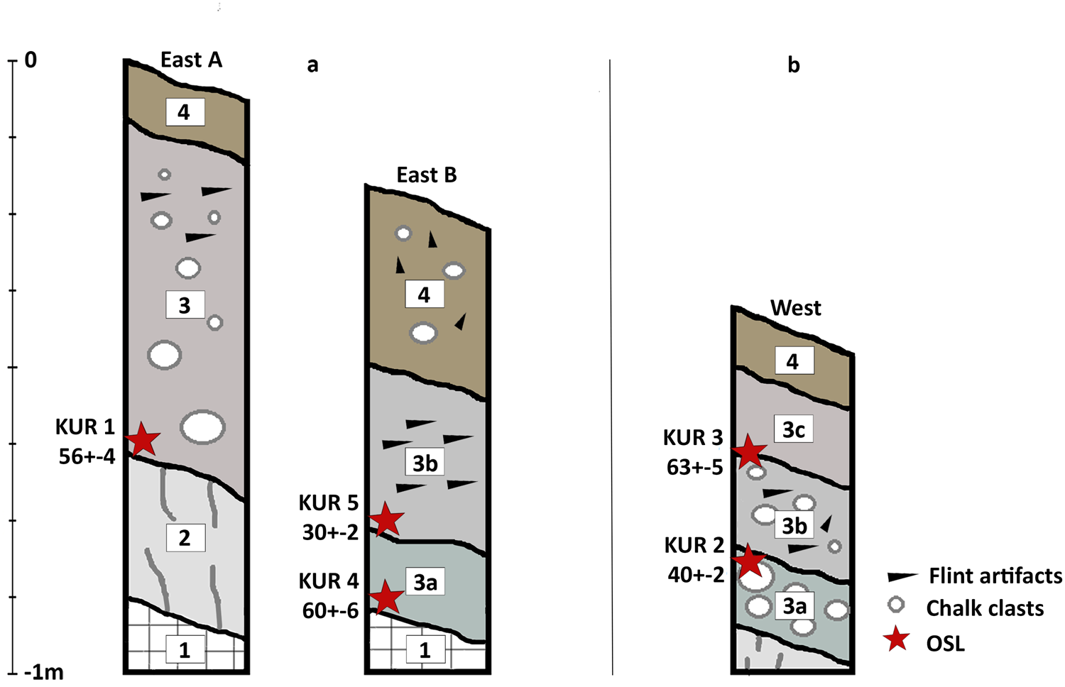
Figure 4. The studied sections of the Nahal Yitnan 7 site in the East (a) and West (b) showing the main units: 1 = fractured, horizontally bedded chalk; 2 = calcrete (nari) surface; 3 = bk calcic loess with artifacts dispersed within upper part and with few clasts; 3a = bk1 calcic loess with matrix-supported clasts; 3b = bk2 calcic loess and clasts with artifacts dispersed within central part of unit; 3c = bk3 calcic loess loam with few clasts; 4 = brown tilled loess with dispersed lithics. OSL ages are in in ka. See Supplementary data 1 for full sediment analysis.
OSL ages from the three stratigraphic sections range from 63 ± 5 ka to 30 ± 2 ka (Fig. 4; Table S2.1). The scatter within each sample, together with the reverse stratigraphic order in the West Trench (Fig. 4b), can be attributed to fluvial–colluvial processes that had affected the slope and the sediments that were analyzed for dating (Porat et al., Reference Porat, Duller, Amit, Zilberman and Enzel2009; Oron et al., Reference Oron, Groman-Yaroslavski, Lavi, Porat and Roskin2019). Most likely, the MP flint artifacts were originally embedded in loess deposited during the Late Pleistocene on top of the bedrock (Crouvi et al., Reference Crouvi, Amit, Porat, Gillespie, McDonald and Enzel2009). However, the slopes were continuously eroded by slopewash. Dynamic studies of slope wash in the semi-arid fringe of the Negev have shown that pebble- and larger-sized clasts are not transported downslope by slope wash, rather by livestock activity and that clast angularity was not a significant factor (Ungar et al., Reference Ungar, Stavi, Lavee and Sarah2010). However, these studies related to decadal-scale rainfall recurrence. We suggest that the extreme rainfall events such as those with recurrences exceeding 10–1000 years generated several brief clast movements. The movement of eroded loess in such events probably contributed to local reposition and transport of clasts and angular to sub-angular artifacts. These erosional processes led to size-related differential dislocation of artifacts in the lithic assemblage and resulted in underrepresentation of the small (<2 cm) component, which may have been eroded downslope. Notably, the two most scattered OSL samples (with overdispersion values of 43–44%; OD in Table S2.1) contain populations of older grains with ages of 75–77 ka (Table S2.1), suggesting that these grains are remnants of a landscape originally covered with older loess. Thus, human activity predates 63 ± 5 ka, whereas the OSL ages represent continuous slope processes and loess mixing and not the initial deposition of the loess sediment.
Artifact transport by slope wash and redeposition on the slope is supported by sedimentology. While the grain size distribution of the > 2-mm fraction of the upper A horizon resembles loess, it is not a primary and pure loess deposit (as in Crouvi et al., Reference Crouvi, Amit, Porat, Gillespie, McDonald and Enzel2009) but locally redeposited loess from slope wash (Table S1.4). The surface cover of thin loess mixed with a dense clast cover testifies to substantial stripping of the primary loess, which in turn explains the loess accumulations within the valleys of the adjacent drainage systems.
The high carbonate content (Table S1.4) of the artifact-rich layers appears to be post-depositional carbonate precipitation. During and following occupation, possibly after a period of erosion, aeolian loess deposition continued. The availability of calcium carbonate from adjacent and underlying bedrock, along with a 30% initial content of carbonates in the loess, led to development of a Bk horizon at the artifact level.
Flint taphonomy
Of the 149 Levallois items in the Nahal Yitnan 7 sample (Table 1), 33 are cores and 116 are knapping products (Levallois debitage and tools). There are no significant differences between cores and products in the distribution of taphonomic variables, with the exception of surface abrasion (more prominent on cores) and breakage (slightly more frequent in the flake sample).
In general, the Nahal Yitnan 7 sample shows moderate frequencies of surface abrasion, with 53% (n = 89) without any ridge abrasion, 46% (n = 68) partially abraded, and only 1% (n = 2) heavily abraded. More than half of the items (57%, n = 85) are complete, but 96% (n = 143) present edge damage, of which 42% (n = 78) present ‘intensive damage’ and 21% (n = 31) show ‘high damage’ (the most intensive damage category). Most items show surface gloss, 72% (n = 108) with significant polish and 19% (n = 28) with a moderate amount. Surface pitting occurs on only 2% (n = 3) of the items.
Seventy-eight percent (n = 114) of the items are patinated. The dominant patina is white (63%, n = 72). An additional 30% (n = 35) bear white stains, 5% (n = 6) show brown patination, and 2% (n = 2) with black/gray patination. In 90% (n = 104) of the cases, patina is apparent on both sides of the item, but only one item bears two different types of patina (on different flaking scars on the same face of the item).
The χ2 tests for Nahal Yitnan showed that the distribution is significantly different from the null hypothesis for all attributes apart from item breakage, where the distribution of breakage condition may be considered random (see Supplementary 5 for test results).
Giv'at Barne'a
Geological and geomorphic setting
The Giv'at Barne'a site is situated in the northwestern fringe of the central Negev Highlands, within the upper eastern reaches of the Wadi-Al-Arish basin of central and northern Sinai (Figs. 1, 5). The site, which is within the Ramat Barne'a plateau, is 10 km south of and below the Central Negev highlands. The plateau is composed of Middle Eocene chalky limestone interbedded with massive limestone units, forming the Matred/Nahal Yeter Formation. These units are primary runoff-generating rock formations (Wieler et al., Reference Wieler, Avni and Rosensaft2016), suggesting that the slopes have been undergoing significant slopewash. Pliocene to Early Pleistocene conglomerates of the Ahuzam Formation deposited along the drainage basins form prominent alluvial terraces rising ~20–30 m above the active channels (Zilberman and Avni, Reference Zilberman and Avni2005). During this long period of surface exposure, the plateau underwent significant weathering, loess deposition, and erosion. In adjacent regions of the Negev, soil formation occurred mainly in topographic lows and colluvial environments (Amit et al., Reference Amit, Enzel and Sharon2006; Enzel et al., Reference Enzel, Amit, Dayan, Crouvi, Kahana, Ziv and Sharon2008; Roskin et al., Reference Roskin, Katra, Porat and Zilberman2013). The soils on the stable carbonate surfaces are mainly brown lithosols and in the colluvial deposits mostly Loessial Serozems (Dan et al., Reference Dan, Yaalon, Koyumdjiski and Raz1970).

Figure 5. Giv'at Barne'a area. (a) Slope from the upper area on top of the hill (right) to the lower area (left). (b) Geological map of the area near the site (marked with black/red diamond) within the Ramat Barne'a plateau (Zilberman and Avni, Reference Zilberman and Avni2005). (c) Lower excavation area. (d) Cores on the surface.
Local context
The Giv'at Barne'a site is situated on a small (~150 × 100 m) geomorphologically stable, flat-topped hill (Fig. S1.5). The upper slope comprises sub-horizontal, well-fractured, well-pitted chalky limestone layers in the form of ledges that contain flint nodules (5–50 cm in diameter). The ledges are separated by several meter-wide horizontal intervals of flat bedrock. The middle and lower northern slope of the hill comprises softer limey chalk. The middle slope is partly covered by loess-dominated fill topped by cobble- to small boulder-size, pitted carbonate clasts, originating upslope.
The moderate (3–5°) lower part of the hillslopes has a colluvium-like morphology, with an unsorted mixture of pitted and angular carbonate pebbles and cobbles creating an incipient desert pavement-like cover. The degree of soil maturity and stability suggests that the soil is no older than Late Pleistocene in age (Table S1.5; Dan et al., Reference Dan, Yaalon, Moshe and Nissim1982; Amit and Gerson, Reference Amit and Gerson1986).
Flint appears mainly as knapped items. Natural flint fragments appear in varying concentrations on the surface.
Scattered knapped items were collected from the top 5 cm of the surface in two selected areas of the Giv'at Barne'a site: one on the hilltop and the other at the northern colluvial slope of the hill, where the artifacts are part of an incipient desert pavement clast cover, whereby dust accumulated below the exposed clasts (Amit and Gerson, Reference Amit and Gerson1986). Based on their typo-technological characteristics, items in these assemblages belong to several archaeological periods, although there is no clear differentiation in patination.
We focused on the diagnostic Middle Paleolithic Levallois items. Some of the Levallois lithic artifacts in the hilltop area were found adjacent to each other and could be refitted, which indicates only restricted movement of material in this part of the site. Post-depositional movement of artifacts contributing to the desert pavement on the colluvial slope may have been minimal, given the low slope angle and lack of sorting by artifact size.
The sediment on the lower colluvial slope was dated by OSL to determine the age of dust buildup beneath the artifacts (Fig. 6; Fig. S1.6). The OSL samples show high over-dispersion values (43% and 49%; Table S2.2), indicating significant mixture or partial bleaching possibly due to downslope transport. OSL ages of 21 ± 2 ka (horizon A) and 32 ± 5 ka (B horizon) represent gradual Late Pleistocene accumulation of dust. The age range of the soil profile, ~37–19 ka, falls within pre-LGM times when there was significant loess deposition (Crouvi et al., Reference Crouvi, Amit, Porat, Gillespie, McDonald and Enzel2009) and fixation (Kidron et al., Reference Kidron, Zohar and Starinsky2014; Lucke and Bäumler, Reference Lucke and Bäumler2021) in the region. As a desert pavement develops in a stable arid environment, the OSL ages post-date the overlying lithics and provide a timeline for down-profile loess accumulation, perhaps during periods of relatively higher precipitation. The rate of deposition decreased in the Holocene when primary and secondary loess availability decreased (Avni et al., Reference Avni, Faershtein, Porat, Enzel and Bar-Yosef2017) and the climate gradually aridified (Baruch and Goring-Morris, Reference Baruch and Goring-Morris1997; Robins et al., Reference Robins, Roskin, Yu, Bookman and Greenbaum2022; Vardi et al., Reference Vardi, Yegorov, Degen-Eisenberg, Boaretto, Langgut, Avni and Caracuta2023).

Figure 6. OSL-dated section of the lower colluvial slope pedosediment (A and B soil horizons) at the Giv'at Barne'a site. Ages are in ka.
The hilltop flint outcrop adjacent to the excavated areas has been used as a raw material source. During flint extraction, blocks were removed from a limestone ledge at the upper and western part of the hillslope. Loess-like dust in cracks and underneath the displaced limestone blocks was also dated by OSL to identify secondary loess deposition post-dating the knapping activities. Three reworked loess samples in the rock fissures were dated to 1.6–0.4 ka (Fig. S1.7; Table S2.2). These young Late Holocene ages, which indicate erosion cycles and refill of the loess, exemplify the dynamic erosive character of the Middle–Late Holocene that inhibits loess fixation on hilltops (Lucke et al., Reference Lucke, Roskin, Vanselow, Bruins, Abu-Jaber, Deckers and Lindauer2019). The location of the studied quarry is on a western-facing slope that was exposed to incoming cyclonic rain fronts (Enzel et al., Reference Enzel, Amit, Dayan, Crouvi, Kahana, Ziv and Sharon2008), which may have enabled relatively intensive processes of erosion.
The hill most likely was covered with loess during parts of the Late Pleistocene because primary loess sections with ages ranging from >90 ka to ca. 14 ka are preserved on hilltops in the Negev highlands (Crouvi et al., Reference Crouvi, Amit, Enzel, Porat and Sandler2008; Crouvi, Reference Crouvi, Amit, Porat, Gillespie, McDonald and Enzel2009). The runoff-generating rock formations at the site led to loess erosion that slightly reorganized the spatial and vertical positions of the lithics. Because no older and overlying loess sediment was preserved on the upper parts of the hill, the time of site-use during the MP cannot be ascertained.
Flint taphonomy
The sample consists of 144 items attributed to the Levallois production system (Table 1). Of these, 77 are cores and 67 are knapping products (Levallois debitage and tools). Seventy-three items were collected from the hilltop surface and 71 from the colluvial slope. There are no significant differences between cores and products in the distribution of taphonomic variables, with the exception of breakage and of surface polish that are slightly more frequent in the debitage compared to cores (Table 1).
The Giv'at Barne'a MP artifacts show high frequencies of abrasion, with only 34% (n = 49) showing no ridge abrasion, 58% (n = 83) partially abraded, and 8% (n = 12) heavily abraded. Most items are complete (64%, n = 93), but 95% (n = 137) show edge damage (46%, n = 66 with significant damage and 19%, n = 27 categorized as high damage).
Many items bear surface gloss, 41% (n = 59) showing a moderate amount and 21% (n = 30) with significant polish. Twenty-six percent (n = 38) of the items in the sample show also pitting on the surface. Almost all items are patinated (98%, n = 142) and the dominant patina is brown (72%, n = 103), with 23% (n = 3 3) having white patina and 4% (n = 6) showing white stains. Patina is apparent on both sides of the item in 95% (n = 133) of the items. Only one item bears two different types of patina (on different flaking scars on the same face of the item).
Several differences are observed between the lithics of the two areas. Forty percent (n = 15) of the items in the colluvial slope show no ridge abrasion, as opposed to only 28% (n = 9) at the hilltop. The lower area is also characterized by more items with white coloring (34%, n = 17), as opposed to only 7% (n = 2) on the hilltop. For the other taphonomic attributes, no differences were observed between the two areas. The χ2 tests for Giva't Barne'a showed that the distribution is significantly different from the null hypothesis for all attributes (see Supplementary data 5 for test results).
Inter-assemblage comparison of flint taphonomy
Inter-assemblage differences were tested statistically using χ2 tests under the null hypothesis of similar distribution of taphonomic variables among the three sites. The results show that the three assemblages differ significantly (in statistical terms) with regards item breakage, edge damage, and patina types. For the other variables, the sample size was not large enough to obtain valid results, so they were tested again combining some of the categories, still following questions of differential preservation between sites (see Supplementary data 5 for full tests results).
The three assemblages differ in the distribution of preservation states (Fig. 7). Giva't Barne'a appears to have undergone more artifact surface abrasion in general, as indicated by higher frequencies of abraded items and of highly abraded pieces in particular, while Nahal Aqev items are mostly unabraded; Nahal Yitnan presents more variable results. These differences are expressed in the correlation test results, showing high correlation between Giva't Barne'a and Nahal Yitnan and a weak correlation between Giva't Barne'a and Nahal Aqev. Broken items are somewhat more frequent in Nahal Aqev compared to the two other sites, yet there is a fairly strong correlation between the sites, with the strongest correlation between Giv'at Barne'a and Nahal Yitnan (Fig. 7b; Supplementary data 5). Edge-damage counts show similar results to surface abrasion (Fig. 7c; Supplementary data 5), Nahal Aqev being distinguished from the others by higher frequencies of artifacts without edge damage, while Giv'at Barne'a and Nahal Yitnan show a high correlation value.

Figure 7. Taphonomy variables on core and knapping products: (a) surface abrasion, (b) item breakage, (c) edge damage.
Some degree of artifact surface gloss was detected in all three assemblages (Fig. 8a). In comparison to the two other case studies, gloss in the Nahal Yitnan assemblage is more frequent, more intensive, and it appears on all cores and on most knapping products. The correlation between Nahal Aqev and Giva't Barne'a is positive, whereas it is strongly negative between these two sites and Nahal Yitnan.

Figure 8. Taphonomy variables on core and knapping products: (a) surface gloss, (b) pitting.
Pitting is rare overall in the three assemblages (Fig. 8b). It is more frequent in Giv'at Barne'a while completely absent from the Nahal Aqev assemblage, but these differences are not statistically valid due to the very low frequencies.
The distributions of patination states in the assemblages track the patterns of surface abrasion and edge damage (Fig. 9a). Nahal Aqev items are less patinated, whereas all items in Giv'at Barne'a and most items in Nahal Yitnan are patinated. Accordingly, there is a high correlation value between Giv'at Barne'a and Nahal Yitnan and very low correlation values between each of these sites and Nahal Aqev.

Figure 9. Coloring variables on core and knapping products: (a) patination, (b) Type of patina, (c) patination side on each item.
The distributions of patina types, however, show a more complex pattern (Fig. 9b). The most dominant patina type differs from one assemblage to the other as manifested in a very weak statistical correlation between Nahal Aqev and Nahal Yitnan and negative correlation values for Giva't Barne'a and the other sites. In Nahal Aqev, white stains and black/gray patina are common on the knapping products but do not appear on the cores. The white patina and desert varnish are most frequent in all the products in the assemblages from Nahal Yitnan and Giv'at Barne'a, respectively. In all three assemblages, patination always appears on both faces of the items (Fig. 9c) with the same coloring. Indeed, distribution of this specific taphonomic variable does not differ statistically among the assemblages and it shows strong correlation between all sites. In the few cases where patination appears on only one face of the core, it is on the flaking surface.
The corelation test results are consistent with the understanding that the differences do not conform to a unified pattern. While all three sites show some similarity in item breakage, pitting, and patination side and differ in the distribution of patina types, some attributes show stronger similarities between varying pairing of the sites. Specifically, Nahal Yitnan and Giv'at Barne'a show stronger corelations for surface abrasion, edge damage, and patination, while Nahal Aqev and Giv'at Barne'a show a stronger correlation due to the lower frequencies of gloss compared to Nahal Yitnan.
In summary, the results of the flint taphonomy analysis show that the three sites differ from one another in most variables. Importantly, all sites are located within a limestone-dominated bedrock in areas that were strongly affected by Late Pleistocene loess accumulation and erosion. We suggest that differences in site accumulation histories and post-depositional processes are manifested in the flint taphonomy. The combination of the results of the different scales of analysis and tying geomorphological processes affecting accumulation and preservation at each site with the taphonomy of the lithic assemblage, may also help work in reverse and relate specific observed taphonomic variables to specific regional or local geomorphic processes (see discussion).
DISCUSSION
The geomorphic, geochronological, and sedimentological analyses, at regional and local scales suggest three scenarios of burial and exposure histories for the three MP assemblages that serve as case studies. Despite some recognized intra- and inter-exposure variations in raw material properties, their common Eocene origin suggests that knapped items are less susceptible to taphonomic effects stemming from differences in raw material. This enables focus on the potential environmental drivers of modification and transformation.
Nahal Aqev represents a rapid accumulation of the archaeological horizon, followed by rapid burial shortly after anthropogenic activity. This is a diametrically different depositional history from the two other sites. At Giv'at Barne'a, the context is that of a long, almost continuous process of surface exposure, where reworked loess gradually accumulated beneath the artifacts. The depositional context of Nahal Yitnan 7 is complex, indicating a last glacial history of loess accumulation followed by episodes of exposure (of different degrees) due to active slope processes and erosion.
Several aspects of the analyses of lithic taphonomy seem to tie in with the geomorphic processes and may be helpful in back-tracking sedimentation cover and local fluvial processes. Taphonomic aspects such as surface abrasion of items, edge damage, pitting, and patination seem to co-vary with exposure duration. On the other hand, attributes such as artifact surface gloss are potentially indicators of localized slopewash, therefore sedimentological processes (represented in this study by the Nahal Yitnan case study) and are not necessarily attributed to long exposure of artifacts on the surface. Edge damage can certainly be a result of trampling during human occupation and, possibly, due to the use of the items. The much lower frequencies of edge damage in Nahal Aqev compared to the other two sites may suggest that long exposure and slope processes have more effect on edge damage than human behavior.
According to previous studies, artifact breakage is affected by the nature of sediments and cycles of coverage and exposure, trampling (by both human and non-human agents) when fully or partially exposed on the surface, and sediment compaction (see also Supplementary data 4), and thus may depict a more complex picture compared to other taphonomic variables. Nahal Aqev showed slightly higher breakage frequencies than the other sites, maybe due to burning and sediment compaction under a 3–4 m burial depth. The breakage at Giv'at Barne'a probably was due mainly to trampling and exposure to the sun since the artifacts were at the surface, while at Nahal Yitnan fluvial and slope processes are the more likely causes. Despite their different accumulation processes, the three analyzed assemblages show similar distributions of breakage, with nearly equal frequencies of broken items. This equifinality of anthropogenic and natural processes is of importance, because it clarifies that this taphonomic variable is a less-reliable proxy of depositional history.
The diversity and complexity of coloring documented in this study and the various inferred processes align with the observations from previous studies (e.g., Hurst and Kelly, Reference Hurst and Kelly1961; Honea, Reference Honea1964; Rottländer, Reference Rottländer1975; Friedman et al., Reference Friedmann, Goren-Inbar, Rosenfeld, Marder and Burian1995; Howard, Reference Howard1999, Reference Howard2002; Burroni et al., Reference Burroni, Donahue, Pollard and Mussi2002; Goldsmith et al., Reference Goldsmith, Enzel and Stein2012, Reference Goldsmith, Stein and Enzel2014; Dorn, Reference Dorn and Pope2013; Caux et al., Reference Caux, Galland, Queffelec and Bordes2018). Our results reaffirm the conclusion that patination should not be considered an a priori indication for higher levels of post-depositional damage or disturbance, and thus a less well-preserved site. The correlation between patina and preservation or exposure versus sediment coverage is not straightforward. Importantly, it is the type of patina (rather than its existence per se) that speaks to the natural or anthropogenic formation processes, both during and after site accumulation. In the arid environment of the Negev desert, coloring of flint surfaces sometimes points to long exposure on the landscape, leading mostly to the formation of desert varnish. In other cases, coloring is related to formation of the archaeological assemblages in a geomorphologically active environment, where white coloring, which is related to alkaline carbonate-rich sediment, will be more frequent at the expense of desert varnish. As in Nahal Yitnan 7, white patina is expected to occur with abrasion and gloss from the slope and fluvial activities. When the white coloring is associated with low rates of abrasion and edge damage, it may likely indicate sediment coverage of a well-preserved horizon, and not necessarily exposure.
Black and gray coloring is strongly associated with direct exposure to fire, and in most cases was caused by human activity. Unlike controlled heating, the exposure of flint item to direct fire probably is an unintentional side-effect of the use of fire on-site, similar to breakage or edge damage in some cases. Black coloring can be an indicator for fire-related activity on site, even when hearths are not recognized. On the other hand, the absence or low frequencies of black and gray coloring from sites such as Giva't Barne'a and Nahal Yitnan may result from re-patination due to exposure on the surface or chemical processes, and therefore cannot disprove fire-related activities.
The links between lithic taphonomy indicators and geomorphic processes are summarized in Table 2. Bearing in mind the complexity and variety of processes that can influence each attribute, as well as the non-linear accumulation of some of them, we merely point out the directionality (increase/decrease) for the processes recognized in the analyzed sites based on the differences observed and the correlation tests.
Table 2. Summary of the links between lithic taphonomy and observed geomorphic processes. Empty cells represent cases where cause/effect cannot be determined based on our sample.

*Depending on sediment chemistry; **Unevenly in specific areas of the site, due to burning.
Another issue arising from our data pertains to the use of luminescence dating in OAS in arid environments. The current study highlights some limitations but also the potential of the method as a tool in understanding site-formation processes. Again, this is related to the different burial and exposure histories for the MP archaeological artifacts in the sample sites. In Nahal Aqev, a dated sedimentological sequence provides the full chronological framework for human occupation. On the other hand, OSL dating at Giv'at Barne'a could not contribute to identifying the timing of human activity. No sediment was deposited with and above the artifacts; dust only accumulated under the artifacts, yet based on their typo-technological characteristics, this accumulation post-dates the items. Finally, in the more complex accumulation scenario of Nahal Yitnan, OSL ages, not directly applicable to the time of the human occupation, provide a minimal age for occupation and help explain and understand redeposition processes of artifacts.
How information is mined from OAS with different degrees of integrity speaks to the frame of mind of researchers as much as it does to the quality of the information gleaned from the sites themselves. Archaeologists typically prefer to study the best-preserved sites (Nahal Aqev in our sample), because these require simpler explanatory scenarios and provide more reliable information about human activities and behaviors. Perhaps counter-intuitively, sites such as Giv'at Barne'a allow an approach based on parsimony. Because site history presents a more linear trend of long-term exposure, there is less variability of formation process. This in turn calls for fewer steps and assumptions in analyzing the sites and the lithic remains in them. In particular cases (e.g., when flat areas form part of the site), assemblages might be more complete—to the degree that items can be refitted—and will offer reliable information about aspects such as lithic technology and activity areas, even if the time frame remains vague. In such cases, the occurrence of refits, combined with their lateral and vertical distributions can be used as a quantitative indicator for the intensity of post-depositional processes (Cziesla, Reference Cziesla, Cziesla, Eickhoff, Arts and Winter1990a,b). Otherwise, it is conceptually easier to limit analyses of such assemblages to very general conclusions (e.g., “hominins were active on this landscape at some point or points in time during the MP”), or to inflate the inferential significance of the archaeological contents of the sites because it is difficult to test empirically the underlying hypotheses.
Our analysis suggests that ‘intermediate’ sites such as Nahal Yitnan 7, with cycles of accumulation and exposure, may contribute environmental information and dating constraints that are missing from long-exposure sites, and can be used in a nuanced manner to infer broader trends in the human occupation of a region. While refitting success is unlikely in such contexts and the assemblages cannot be used, for example, in spatial analyses, the assemblages can be mined for technological information (see Hovers et al., Reference Hovers, Ekshtain, Greenbaum, Malinsky-Buller, Nir and Yeshurun2014), timing and length of the occupation, and be discussed in the context of broader regional schemes.
In the current case study, the whole assemblage of Nahal Aqev can be included in the technological and typological analysis, can be assigned confidently to the MP, and its OSL dating places it within ca. 130 ka or older (Barzilai et al., Reference Barzilai, Oron, Porat, White, Timms, Blockley and Zular2022). In Giv'at Barne'a, one may recognize and discuss the nature of the site as a workshop, but due to the mixture with knapping products from several periods, we cannot include non-Levallois items in the analysis and reconstruct the whole reduction sequence. In contrast, at the site of Nahal Yitnan, despite its complex depositional history, one can identify the better-preserved areas and include all lithic items in the technological analysis (e.g., technologically non-diagnostic items), such that the emerging understanding of the characteristics of the assemblage is based on a reliable dataset. While taking into consideration that the site probably represents more than one MP occupation event and may not contain a complete assemblage, it is possible to rule out mixture with other periods based on the taphonomic characteristics. Moreover, due to the geomorphic reconstruction of the loess cover–erosion cycles, the site can be tied to locally and regionally dated sequences and the temporal placement of the assemblage can be further constrained.
Integration of the three levels of analysis (i.e., examining the associations among regional, local, and site-specific depositional histories) allowed us to clarify the potential role of each such scale in understanding arid region OAS, in which lithic artifacts are the most common, and often the only, indications of human presence on the landscape. Such insights for the Negev MP are significant because technological traditions in this area have been argued to be linked to those observed in several neighboring areas (e.g., Goder-Goldberger et al., Reference Goder-Goldberger, Gubenko and Hovers2016; Barzilai et al., Reference Barzilai, Oron, Porat, White, Timms, Blockley and Zular2022). The Levantine MP has often been characterized through a three-phase sequence of technological changes, as evinced in the long sequence of Tabun Cave (e.g., Bar-Yosef, Reference Bar-Yosef, Akazawa, Aoki and Bar-Yosef1998). More recently, it was argued that the tri-partite Tabun model of technological change may more accurately describe MP technological variability in the Mediterranean ecological zone, but is less compelling for the arid areas because of the different ecological affordances and settlement systems in such areas (Hovers, Reference Hovers2009). Clarifying the temporal span and integrity of the assemblages from OAS in the arid zone can now address such questions with better-informed empirical data.
Our work also allows us to construct a conceptual model for arid region OAS (Fig. 10), drawing attention to the variety of potential relationships among environment, human behavior, and the archaeological record in arid conditions. The use of these artifacts as indicators for environmental effects has great value. At the site level, it allows us to assess accumulation history, but for regional research it can also be used as a tool for coherent integration of data from different sites into one data set. The understanding of where each site is placed within the range of exposure and preservation possibilities in the specific region allows, in turn, augmentation of the regional archaeological data base by using informed and critically evaluated data. Thus, we can mine the regional data base for information that otherwise would be overlooked or considered unreliable, or would be considered as introducing undesirable ‘noise,’ rank them differentially and choose the relevant assemblage from each site. The three model sites presented in this paper are part of a larger sample of 11 MP assemblages from the Negev, all analyzed in a similar way. In turn, the way that each one of the project assemblages can contribute to the regional research is assessed and the data is integrated and used to refine our knowledge of the human presence in the Negev during the MP.
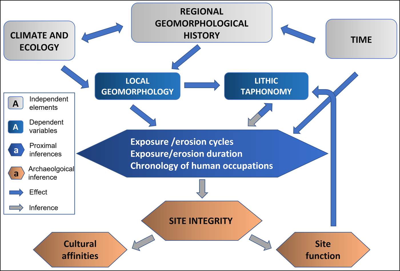
Figure 10. A schematic illustration for the conceptual model.
Finally, we suggest that our conceptual model bears implications for areas beyond the Negev desert, for example Arabia (Hilbert et al., Reference Hilbert, Crassard, Rose, Geiling and Usik2016; Groucutt et al., Reference Groucutt, White, Scerri, Andrieux, Clark-Wilson, Breeze and Armitage2021) and north and northeastern Africa (Olszewski et al., Reference Olszewski, Dibble, McPherron, Schurmans, Chiotti and Smith2010; Foley and Lahr, Reference Foley and Lahr2015), where much cultural material is known from surface collections. The kind of analysis that we used in our ‘proof of concept’ study may help in obtaining more information and in reaching a more informed evaluation of such records. Such additional insights may bear on the potential contribution of similar records to the ongoing discussion of Late Pleistocene dispersals and contacts among modern human populations and their contemporaries in arid areas, in which such regional records play a role.
Supplementary Material
The supplementary material for this article can be found at https://doi.org/10.1017/qua.2023.31
Acknowledgments
The excavations in Nahal Yitnan 7 and Giv'at Barne'a were conducted on behalf of the Israel Antiquities Authority, which granted us permission to use all figures of the excavations and finds from these sites. Artifacts were photographed by C. Amit and D. Gazit. The authors thank O. Barzilai and E. Boaretto for allowing the use of unpublished data from Nahal Aqev. Sedimentological analysis was conducted at the Sedimentology Laboratories at the University of Haifa. Maya Oron's PhD project has been supported by the IAA scholarship program and a research grant from the Ruth Amiran Fund for archaeological research in Israel, awarded by The Institute of Archaeology, The Hebrew University of Jerusalem.
Competing Interests
The authors declare no competing interests.


 Open access