


Introduction
The Main Base of the British North Greenland Expedition was established in Dronning Louise Land, a mountainous region within the margin of the ice cap in north-east Greenland (Fig. 1, p. 705). The land mass, separated from the coastal mountains by two great outlet glaciers, Storstrommen and Bistrup Bræ, increases in height from north-east to the south-west where the mountains reach altitudes of almost 2700 m. above sea level. There are no higher mountains in west and north Greenland, and only two mountain ranges in east Greenland have peaks rising to greater heights. Thus some of the highest mountains in the whole of Greenland are to be found in Dronning Louise Land.
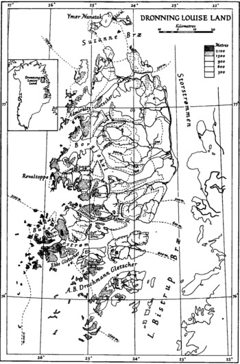
Fig. 1. Contour map of Dronning Louise Land
All the major glaciers of Dronning Louise Land were traversed during the geological survey, and at the same time numerous glaciological observations were recorded. Only one aspect of these observations is considered in this paper, which attempts to show that the outlet glaciers of the ice cap must pass over high rock thresholds in order to escape through the mountains and that, because the emerging thresholds separate the glaciers from their ice cap source as the ice cap decreases in height, a process of starvation has played a dominant rôle in the final stages of recession of the glaciers.
Recession and the Contributing Factors
Throughout Dronning Louise Land it is clear that the ice was formerly of much greater extent. Erratics may be found on most of the upland surfaces, showing that at one time the ice covered almost the whole of the region. Many glaciated valleys dissect the upland erosion surfaces, and ridges of moraine are plentiful in localities favorable to their preservation. Some of these valleys are occupied by large lakes, dammed at one or both ends by ice (Fig. 1). Corne glaciers, even in the higher areas, are often reduced to small lobes of ice occupying large excavations, and many corries are now empty. The floor of the corrie in Fig. 2 (p. 709) is about 1600 m. above sea level, and the mountains above it reach altitudes of 2300 m. The corrie glaciers which remain are diminishing in size. Examination of nunataks within and near Dronning Louise Land show that many of them result from significant thinning of the ice cap, the rock floor of which is now being exposed. Many of these nunataks are lower than the surrounding ice and are bordered on their up-stream side by a horseshoe moraine which stands perched on the ice sloping down to the nunatak. Such nunataks are common around the northern margin of Dronning Louise Land, and their presence suggests that bedrock is nowhere very deep beneath the surface of the ice cap in this area. The fact that Ymer Nunatak, to the north of the main land mass, is almost completely covered by a layer of till is evidence that the ice cap here was once at least 450 m. thicker than it is to-day.
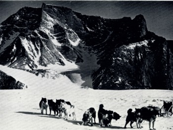
Fig. 2. A conic on the north wall of the upper Budolfi Glacier (Isstrom)
There is ample evidence of ice recession in Dronning Louise Land and we may now consider factors which have contributed to the recession. It is well established that the glaciers of the northern hemisphere are receding, and this is attributed to an amelioration of climate. The state of the corrie glaciers of Dronning Louise Land could be the result of increase in mean annual temperature, of decrease in the amount of local precipitation, or of a combination of both these factors. The thinning of the ice cap may be due to the general increase in temperature in the northern hemisphere, or it may be due to a decrease in the amount of precipitation over the ice cap further west. Detailed studies of the regime of the ice cap and of the outflow glaciers are required before the relative importance of these factors may be assessed. Since the larger glaciers flow eastwards through Dronning Louise Land from the ice cap, relations between the ice cap and these glaciers are clearly important. As FlintReference Flint and Boyd 1 points out “The altitudes of the rock thresholds if any, … are unknown. If these thresholds are relatively high, and if the ice over them is therefore relatively thin, a slight decrease in nourishment farther west might thin the ice over the thresholds enough to cause a disproportionately great shrinkage of the outlet tongues to the east.” It is a principal purpose of this paper to establish how the decrease in height of the ice cap, at least along its margins, has played an important part in the recession of some of the glaciers of Dronning Louise Land.
High rock thresholds do exist in the west of Dronning Louise Land. Examples can now be described, and their effect on the recession of the glaciers discussed.
The Effect of Rock Thresholds
A mountain range is present in the west, increasing in height from north to south and culminating in the region of alpine peaks which rise to almost 2700 m. above sea level. The contours on the map (Fig. 1) show the nature of the barrier presented to the ice by this mountain range ; along a front of over 150 km. it is breached by only three major glaciers, Admiralty Gletscher, Borgjökel and Budolfi Isstrøm. The. wide Suzanne Bræ; sweeps eastwards around the north of Dronning Louise Land, and the line of ice hills and steep ice slopes which extends to the north from the north-west corner of the land indicates that this glacier passes over a prominent threshold in the west. South of the alpine area, the mountain range continues as a line of nunataks and steep ice slopes (indicating buried peaks) which divides the ice cap proper from a lower expanse of ice within the limits of Dronning Louise Land. Two glaciers flow from this area, Ebbe Gletscher and A. B. Drachmann Gletscher, but neither of them extends westwards through the mountain range. Thus there is an almost continuous mountain barrier extending from north to south along the western margin of Dronning Louise Land; 20 to 30 km. to the west of Dronning Louise Land there is, in addition, a line of nunataks representing the peaks of a buried mountain range which must reduce the quantity of ice reaching the mountains of Dronning Louise Land. The presence of this buried mountain range has been confirmed by the geophysical results of the British North Greenland Expedition.
The large outflow glaciers of west Greenland, such as Umiamako Isbræ, Rink Isbræ and Jakobshavn Isbræ; extend far into the ice cap as high discharge ice streams occupying deep sub-glacial trenchesReference Bauer 2 . The three glaciers which breach the western mountain barrier of Dronning Louise Land show no signs of similar sub-glacial trenches extending into the ice cap. The large glaciers passing between the high cliffs are soon lost among the low ridges, hills and valleys which form the surface of the ice cap close to Dronning Louise Land, which fact strongly suggests that even the major glaciers pass over relatively high thresholds before flowing through Dronning Louise Land.
The presence of high rock thresholds must constantly restrict the quantity of ice flowing eastwards from the ice cap, but their effect will only become marked when the thickness of the ice flowing over the thresholds is reduced to the same order as that of the glaciers east of the mountains. Any further decrease in height of the ice cap, and therefore of the thickness of ice flowing over the thresholds, must then be reflected in a relatively more rapid recession of the glaciers.
All stages of this process may be observed in different parts of Dronning Louise Land. Most of the smaller glaciers in the west clearly originated as ice streams spilling from the ice cap through mountain passes. Fig. 3 (p. 709) shows examples of small overflow glaciers of this type which flow directly from the ice cap. In many places, they now lie at higher levels than the ice cap, and as they are then only supplied by local precipitation, which is insufficient to maintain them under present conditions, they are receding. South of the alpine peaks, there are several U-shaped valleys, high in the mountains, showing the positions of glacially deepened passes which are now ice-free.
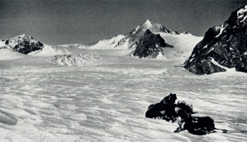
Fig. 3. Small glaciers spilling from the ice cap through mountain passes on the north side of the Budolfi Glacier (Isstrom)
A more striking example is offered by Eigil Sø. The surface of the lake lies in a deep trench at 650 m. above sea level, where the upland surface is about 1500 m. high, and it extends westwards for 20 km. almost to the foot of Revaltoppe, a mountain range which rises to an altitude of 2500 m. above sea level. This deep valley was carved by a large glacier and fed by tributary glaciers from the north and south as well as from the west. No glaciers reach the valley to-day ; the source of supply of ice has been cut off by the high mountains around the valley as the ice cap decreased in height.
An intermediate stage in the process of recession, resulting from starvation, is well illustrated by the Pony Gletscher. Between the Revaltoppe and the area of alpine peaks, the ice cap extends eastwards at a high altitude, about 1850 m. above sea level, and from this tongue of ice the Pony Gletscher flows into Vedel Sø, a lake which is dammed at its east end by the Ejnar Gletscher. Entry to the glacier from the west is down a series of steep ice slopes which give way quite sharply to a normal glacier tongue. The snout of the glacier passes into the lake by way of a steep, smoothly convex slope. There are no signs of calving from the snout, and when the glacier was visited in April 1954 there were no pressure ridges formed in the lake ice next to the snout, showing that there had been no movement of the glacier during the preceding winter. In contrast, winter movement of the Ejnar Gletscher at the other end of the lake had produced such a confusion of pressure ridges in the lake ice that it was difficult to find a route through them. The steep slopes at the head of the Pony Gletscher suggest the presence of a glacially modified corrie beneath the ice. The sides, head wall and floor of the corrie, merging into the tongue of the glacier, are clearly reflected in the surface contours of the ice cap in this area. The probable history of the glacier is readily deduced. With the onset of glacierization a corrie, which was the source of an eastward flowing glacier, formed in the high mountains. The ice cap was subsequently formed and it expanded and grew by processes which need not concern us here. When the ice cap became high enough, it flowed across the divide south of Revaltoppe and augmented the supply of ice to the relatively small corrie glacier, widening and deepening its valley. The glacier was then fed directly by the ice cap, and formed a tributary of the large Budolfi Isstrøm. Decrease in the level of the ice cap has virtually cut off the supply of ice from the west, and the glacier is now a stagnant remnant occupying a valley which is too large for it. Lateral moraines lying high on the sides of the lake are evidence of a much greater glacier which once flowed through this valley.
The shrinkage of this glacier, the disappearance of the glacier which formerly flowed through the valley containing Eigil Sø and the disappearance of the glaciers which once flowed through the glaciated passes high in the mountains are due primarily to thinning of the ice over the high thresholds of the mountain barrier in the west. I venture to forecast that if there should be a further slight decrease in the height of the ice cap, there would ensue a relatively rapid shrinkage and disappearance of all the glaciers, leaving Dronning Louise Land as a deeply dissected, ice-free mountain upland.
Conclusion
The evidence outlined above is sufficient to show that the recession of the glaciers of Dronning Louise Land is controlled, in the final stages, by the thinning of the ice cap and the consequent emergence of rock thresholds.
The margin of the ice cap in east Greenland is not well known, but from the photographs appearing in recent publications of Meddelelser om Gronland Reference Katz 3 it would appear that many of the glaciers of east Greenland have high rock thresholds at the ice cap margin. If this proves to be the case, the starvation of these glaciers by a process of being cut off from their ice cap source may be a much more important factor in their recent recession than has been previously recognized. The geophysical work of the British North Greenland Expedition has confirmed the presence of mountain ranges beneath the ice cap, parallel to the western mountain range of Dronning Louise Land, and as our knowledge of the sub-glacial topography of the ice cap increases, we will be better able to understand the nature of the escape routes of the ice as it makes its way eastwards and through the coastal mountains.
The writer is indebted to Dr. H. I. Dreyer for much constructive criticism during the preparation of this paper.


