Introduction
The stability of the West Antarctic ice sheet is related to the behavior of the fast-moving ice streams that drain it. Much effort thus has been directed towards understanding these ice streams. The United States program has especially focused on those ice streams (A E) flowing across the Siple Coast into the Ross Ice Shelf Among the most surprising discoveries on the Siple Coast ice streams has been how rapidly they are changing now and have changed recently (see review by Reference Alley and WhillansAlley and Whillans (1991)).
Many areas have been examined in detail, and most show non-steady behavior, including large changes in ice, velocity and grounding-line position over historical periods (Reference Stephenson and BindschadlerStephenson and Bindschadler, 1988; Reference WhillansThomas and others, 1988; Reference BinelschadlerBindschadler, 1993) and modern rates of thickness change approaching or exceeding 1m year1 in several areas (Reference MacAyeal, Bindschadler, Shabtaie, Stephenson and BentleyMacAyeal and others, 1987, Reference MacAyeal, Bindschadler, Shabtaie, Stephenson and Bentley1989; Reference Shabtaie, Bentley, Binelschadler and MacAyealShabtaie and others, 1988; Reference Whillans and BindschadlerWhillans and Bindsebadlcr, 1988; Reference Bindschadler, Roberts and MacAyealBindschadler and others, 1989, Reference Binelschadler1993). Probably the most dramatic change is that Ice Stream C apparently stagnated about a century ago (Reference RoseRose, 1979; Reference Shabtaie, Whillans and BentleyShabtaie and others, 1987; Reference Retzlaff and BentleyRetzlaff and Bentley, 1993); it has the radar signature of an active ice stream, but the crevasses of its shear margins and within the ice stream itself are buried by about a century of snowfall.
By analogy to its neighbors, lce Stream C probably was moving several hundred meters per year. No data are available on how long it took to slow down, but it dropped beneath the speed threshold needed to keep marginal crevasses open almost synchronously (within about 30 years) along about 300 km of the ice stream extending up-glacier from the grounding line (Reference Retzlaff and BentleyRetzlaff and Bentley, 1993).
Such a dramatic change in ice-stream behavior poses a large challenge to glaciological research. In seeking to understand it, we may learn much about the behavior of ice streams.
Previous hypotheses
The behavior of Ice Stream C has provoked much speculation. Reference RoseRose (1979) suggested that it is a surging ice stream, which cycles between fast and slow flow in the same way as some mountain glaciers do. This simple analogy is unlikely because most surging glaciers spend most of their time in the slow mode, but four of the five main Siple Coast ice streams are moving rapidly. Attempts to model surges in Antarctic ice streams failed to produce them (Reference Radok, Jenssen and McInnesRadok and others, 1987). Surging in mountain glaciers seems to require build-up of ice in a reservoir area, and surge termination follows draw-down of the reservoir, but the ice reservoir (catchment) of Ice Stream C is not strongly drawn down and looks like those of the other Siple Coast ice streams. Surging thus seems unlikely and we discount this hypothesis. However, some of the mechanisms that have been associated with surging might remain viable under different guises and below we discuss one (switches between channelized and distributed subglacial water drainages).
In discussing surging and changes in catchment areas, Reference RoseRose (1979) also indirectly suggested the possibility of piracy-perhaps lee Stream B had beheaded Ice Stream C by stealing ice from its catchment area. However, careful mapping (Reference Shabtaie, Bentley, Binelschadler and MacAyealShabtaie and others, 1988; Reference RoseRetzlaff and others, 1993) shows that this has not happened, although continuation of ongoing trends in thickness change might cause it to happen in the future.
In his discussion of Reference RoseRose's (1979) paper and in Reference Thomas, Stephenson, Bindschadler, Shabtaie and BentleyThomas and others (1988), Thomas suggested that recent grounding near the mouth of Ice Stream C might have created an ice plain or ice rises that generated backpressure and stopped the ice stream. By analogy to Ice Stream B, this grounding might have been caused by rapid sedimentation at the grounding line, possibly supplied by a deforming subglacial till (Reference Alley, Blankenship, Bentley and RooneyAlley and others, 1987a). However, we consider it unlikely that this would stop the ice stream, primarily because of analogy to Ice Stream B. There, an extensive ice plain leads to the Crary Ice Rise complex. Crary Ice Rise has a large restraining effect on ice flow (Reference MacAyeal, Bindschadler, Shabtaie, Stephenson and BentleyMacAyeal and others, 1987,Reference MacAyeal, Bindschadler, Shabtaie, Stephenson and Bentley1989), yet Ice Stream B curves around it and flows vigorously. On the ice plain, some strain rates are actually extensional along flow (Reference Bindschadler, Stephenson, MacAyeal and ShabtaieBindschadler and others, 1987) and not compressional as would be expected if backpressure were braking the ice stream. Most of the strain rates do show compression along flow (Reference Bindschadler, Stephenson, MacAyeal and ShabtaieBindschadler and others, 1987), but this can be explained by the transverse extension caused by down-glacier widening of the ice stream without appealing to ice-plain back-pressure; Reference Bindschadler, Stephenson, MacAyeal and ShabtaieBindschadler and others (1987) neglected gradients in longitudinal deviatoric stresses in their assessment of the force balance of the ice plain of Ice Stream B.
Reference Retzlaff and BentleyRetzlaff and Bentley (1993) suggested that instability of a distributed subglacial water system may have led to channelization of the water and reduced basal lubrication, stopping the ice stream. Water apparently flows beneath Ice Stream B in a high-pressure distributed system, which can be modeled as a thin film, and the high water pressures allow rapid bed deformation or sliding (Reference Alley, Blankenship, Bentley and RooneyAlley and others, 1987b; Reference AlleyAlley, 1989b; Reference KambKamb, 1991; Reference Kamb and EngelhardtKamb and Engelhardt, (1991)). Reference WalderWalder (1982) showed that, if such a distributed water system becomes thicker than a few millimeters, perturbations in its thickness will tend to grow. A film system thus might collapse into a low-pressure channelized system. Channel formation would be most likely near the grounding line, where the water supply is largest. Once formed, channels might grow headward. We know of no accurate estimates of possible rates of headward growth of channels into a distributed water system, or even whether such growth could occur. (The halder analysis is two-dimensional and does not consider variations along flow.) However, if up-glacier growth rates occurred at rates similar to down-glacier flow rates of water, just a few years or decades would be needed for channels to extend the length of the ice stream (see below).
Reference KambKamb and others (1985) and Reference KamhKamb (1987) discussed the collapse within hours of a distributed, linked-cavity drainage system to a channelized one beneath Variegated Glacier, Alaska, which caused termination of a surge of the glacier. However, this behavior may not tell us much about Ice Stream C. Variegated Glacier normally has a channelized drainage system maintained by abundant surface meltwater reaching the bed through moulins. Disruption of this surface-fed, channelized system triggered the surge, and re-establishment of this channelized system terminated the surge in a wave that propagated down-glacier. Theory suggests the possibility of qualitatively different behavior of subglacial water with point versus distributed sources (e.g. Reference WeertmanWeertman, 1972). Because Ice Stream C lacks delivery of abundant surface melt to the bed at certain points, there is no reason to expect the basal system of Ice Stream C to change in the same way as observed beneath Variegated Glacier at the end of its surge.
Arguments have been advanced against the possibility of film-to-channel collapse beneath an ice stream (Reference AlleyAlley, 1989a). The Walder instability requires a film of more than a few millimeters thickness. Calculations for the likely film thickness at the down-glacier end of Ice Stream C, following Reference Alley, Blankenship, Bentley and RooneyAlley and others (1987b) and including likely uncertainties in the basal shear stress and the geothermal flux, include within the error limits films thick enough to be unstable and thin enough to be stable. Reference Weertman and BirchfieldWeertman and Birchfield (1983) argued that, although the perturbation analysis of Reference WalderWalder (1982) was correct, development of the infinitesimal perturbations to finite size would induce other changes that would prevent maintenance of steady-state channels. This question is not fully solved.
Perhaps more importantly, the Walder analysis assumed a rigid bed. Soft sediments could creep into and close an incipient channel, as they have been observed to creep into subglacial tunnels (Reference BoultonBoulton, 1976;Reference Boulton and Hindmarsh Boulton and Hindmarsh, 1987). An incipient channel would have small sediment-transport capacity, and so would be closed rapidly, preventing growth to a low-pressure, steady-state configuration (Reference AlleyAlley, 1989a). Reference Walder and FowlerWalder and Fowler (1994) showed that any channels that do form over a soft bed will have relatively high water pressure owing to the effects of the soft sediment, allowing continuation of some basal lubrication.
We recognize that the Reference Weertman and BirchfieldWeertman and Birchfield (1983) and Reference AlleyAlley (1989a) arguments are based on theory and that theory can err. We thus maintain the film-to-channel collapse of Reference Retzlaff and BentleyRetzlaff and Bentley (1993) as a working hypothesis.
A thick, rapidly deforming glacier bed allows much debris transport and thus requires a large debris source. Unconsolidated or poorly consolidated sediments are the most likely source. Reference Boulton and JonesBoulton and Jones (1979) pointed out that long-term action of ice would remove such sediments. This would cause the deforming-till layer to thin, which might slow or stop the ice stream. Reference Anandakrishnan and BentleyAnandakrishnan and Bentley (1994) have reported that low seismic-velocity (hence poorly consolidated and easily eroded) sediments exist beneath the till of Ice Stream C, with thickness varying from 400 m at once site to only 100m nearby. Such large variations suggest the possibility of these sediments pinching out elsewhere. Because a till layer of variable thickness does seem to exist widely beneath Ice Stream C (Reference Atre and BentleyAtre and Bentley, 1990, Reference Atre and Bentely1993), full loss of the sediments supplying that till layer cannot have occurred. However, sediment loss by erosion could have caused till thinning, which in turn could have caused the growth of sticky spots of thin or zero till that slowed the ice stream (Reference Atre and BentelyAlley, 1993). Such sticky spots figure prominently in our water-piracy hypothesis.
The possibility of water piracy by Ice Stream B combines elements of Rose's ice piracy and Retzlaff and Bentley's film-to-channel collapse. We began considering the water-piracy idea in group meetings at the University of Wisconsin during the mid-1980s and it has influenced our field and theoretical studies since then. It has been

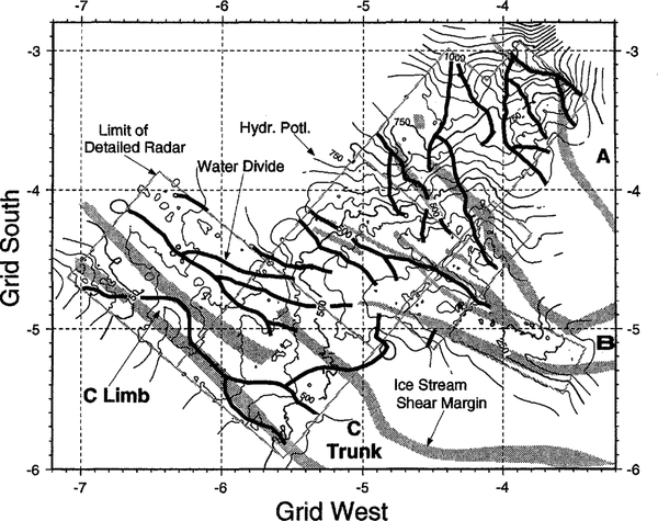
Fig. 1 Hydrologic potential map of the up-glacier parts of Ice Streams Band C. Potential is calculated as ice-surface elevation minus 0.1 x bed elevation in m (Reference Stephenson and BindschadlerPaterson, 1981, p. 142), and is equivalent to a head in units of ice thickness; multiply all values by pig 9000, where pi is the ice density, to obtain the potential in units of Pa. One degree on the grid scale is 111km. Water-flow divides are indicated by heavy lines, and show water flow from the limb of lee Stream C to lee Stream B.
presented briefly by Reference Alley and WhillansAlley and Whillans (1991). We now believe that enough data and interpretations are available to justify presentation to the community in greater detail.
Critical Observations
Interpretations of several new data sets are critical to our hypothesis. We summarize these briefly here. We find it useful to distinguish between the wide, main, downglacier part of the ice stream, which we call the trunk, and the narrow up-glacier extension, which we call the limb (Fig. 1).
The ice-stream trunk stopped almost synchronously (Reference RoseRetzlaff and Bendey, 1993). Ice-flow velocities on the trunk of Ice Stream C are barely more than measurement error (Reference Whillans, Bolzan and ShabtaicWhillans and others, 1987), although slow basal motion continues (Reference Anandakrishnan and BentleyAnandakrishnan and Bentley, 1993). The ice stream is delineated on radar records by the marginal crevassing typical of active ice streams, but the crevasses are bridged by many meters of snow accumulation. Short-pulse radar measurements of snow-bridge thicknesses combined with accumulation-rate measurements show that the trunk stopped nearly synchronously (± 30 years) about 130 years ago. A profile crossing the up-glacier end of the trunk and the down-glacier end of the limb shows a slightly more recent shut-down, but the difference is not statistically significant.
The limb of Ice Stream C extending up-glacier may still be active. A short-pulse radar profile across the limb well up-glacier shows a significantly more recent stagnation than for the trunk (Reference Retzlaff and BentleyRetzlaff and Bentley, 1993). Near the true-north side of the limb, open crevasses have been observed from aircraft, indicating active ice flow (Reference Retzlaff and BentleyRetzlaff and Bentley, 1990, Reference Retzlaff and Bentley1993). Active ice flow with many crevasses bridged might occur; balance velocities (and by analogy, whatever velocities apply to the current conditions) for the limb are slower than for the main part of an active ice stream, so the limb should shear past its margins and open its marginal crevasses more slowly than typical for active ice streams, allowing a greater chance of bridging those crevasses. No ice-flow velocities have been measured in the limb but, just beside it toward Ice _ Stream B, Reference Whillans and VeenWhillans and Van der Veen (1993) observed a velocity transitional between values typical of inland-ice and ice-stream flow, consistent with transitional flow there from inland to ice stream.
The bed of the trunk is well lubricated in most places, although with local sticky spots supporting most of the basal shear stress. Micro-earthquake monitoring near Upstream C camp on the trunk (Reference Anandakrishnan and BentleyAnandakrishnan and Bentley, 1993) shows that brittle fracture is much more common beneath Ice Stream C than beneath Ice Stream B. Quakes are generated along small thrust faults at or near, and parallel to, the ice-stream bed, with slip in the direction of local ice flow. The rupture surfaces are on the order of 10m across. Stress drops in the quakes are typically on the order of 1 bar (105 Pa) and a quake preferentially sets off others within 400 ± 400 m but extending as far as 1.5 km (Reference Anandakrishnan and BentleyAnandakrishnan and Bentley, 1993; Reference Anandakrishnan and AlleyAnandakrishnan and Alley, 1994).
Stress drops in ordinary earthquakes are not expected to relieve all of the applied stress. Earlier workers (e.g. Reference Wyss and BruneWyss and Brune, 1968; Reference BruneBrune, 1970) suggested that perhaps 1-10% of the applied stress is relieved in a quake. Newer estimates are scarce, possibly because of the difficulty of estimating the applied stress. If simple analogy holds and these old estimates are approximately accurate, the micro-earthquakes under Ice Stream C occur on failure planes in sticky-spot regions supporting 100-1000 times more basal shear stress than the regional average of about 0.1 bar (Reference Anandakrishnan and AlleyAnandakrishnan and Alley, 1994). In most earthquakes, aftershocks are generated in a region of similar linear dimension to the length of the rupture surface (Reference DasDas, 1992; in a single case, aftershocks have been documented to a distance of 17 times the source size; Reference HillHill and others, 1993). Again, if simple analogy holds, the observation of aftershocks within hundreds of meters of a quake suggests a rupture surface of hundreds of meters, compared to an estimate of 10m from the corner frequency of the energy spectrum of the quakes (Reference Anandakrishnan and BentleyAnandakrishnan and Bentley, 1993; Reference Anandakrishnan and AlleyAnandakrishnan and Alley, 1994).
The simplest interpretation of these data is that regions between sticky spots arc very well lubricated, so that stress is transmitted up to 1.5 km for rupture of a locked region spanning 10m. A 10 bar stress on 10m long sticky spots between perfectly lubricated areas under an average basal shear stress of 0.1 bar would imply 100 m spacing of the sticky spots. Non-zero strength of the lubricated areas would increase the spacing we estimate. In comparison, the clustering of micro-earthquakes suggests a few hundred meters spacing (Reference Anandakrishnan and AlleyAnandakrishnan and Alley, 1994), reasonably good agreement given the order-of-magnitude nature of these calculations.
These data suggest that in most places the ice stream is well lubricated and supports little or no basal shear stress; localized sticky spots support most of the stress (Reference Anandakrishnan and AlleyAnandakrishnan and Alley, 1994). This would concentrate the stress sufficiently to allow brittle fracture and would allow stress changes associated with a micro-earthquake to be transmitted long distances to other sticky spots. The scarcity of seismicity beneath Ice Stream B suggests that any sticky spots there are better lubricated than those beneath Ice Stream C (Reference Anandakrishnan and BentleyAnandakrishnan and Bentley, 1993).
Active-seismic data, and more recently drilling, have shown that Ice Stream B is underlain by a meters thick, very soft till that probably deforms and lubricates basal motion (Reference Blankenship, Bentley, Rooney and AlleyBlankenship and others, 1987;Reference Kamb and Engelhardt Kamb and Engelhardt, 1991). Theoretical estimates of its strength (Reference Alley, Blankenship, Bentley and RooneyAlley and others, 1987b) and laboratory (Reference KambKamb, 1991; Reference Kamb and EngelhardtKamb and Engelhardt, 1991) and small-scale in-situ strength tests (personal communication from H. Engelhardt and B. Kamb) preclude basal models in which much of the bed supports a significant shear stress without deforming rapidly.
The original interpretations of the basal properties of Ice Stream B were based on seismic-velocity analysis and on seismic profiling (Reference Blankenship, Bentley, Rooney and AlleyBlankenship and others, 1987; Reference Rooney, Blankenship, Alley and BentleyRooney and others, 1987). No velocity analyses have been conducted on Ice Stream C, but profiling (Reference Atre and BentelyAtre and Bentley, 1993) reveals a layer apparently similar to that beneath Ice Stream B. Seismic-phase analysis shows that extensive parts of this layer have low seismic velocity similar to values beneath Ice Stream B. Thus, it is likely that a soft, deformable till exists beneath Ice Stream C. Phase analysis also suggests spatial variability in the properties of the uppermost part of the till but cannot reveal how large the variations arc (Reference Atre and BentleyAtre and Bentley, 1990, Reference Atre and Bentely1993).
Imagery of the ice stream shows an "island" of ice in its center that looks more mottled than its surroundings, and the flowlines in the surroundings seem to be deflected around that island (Reference Jacobel, Gades, Gottschling, Hodge and WrightJacobel and others, 1993). Radar data show that the island coincides with a bedrock high Reference Jacobel, Gades, Gottschling, Hodge and WrightJacobel and others, 1993). High spatial variability in imagery, probably linked to bedrock highs, is known to occur over regions of enhanced basal drag (sticky spots) on Ice Stream E (MacAyeal, 1992), which strengthens the possibility that localized sticky spots exist beneath Ice Stream C.
Water piracy has occurred from the catchment area of Ice Stream C to the trunk of Ice Stream Reference RoseB. Rose (1979) and Reference Shabtaie and BentleyShabtaie and Bentley (1988) noted the combination of steep bedrock topography under flat surface topography, suggesting important dynamic effects. In particular, subglacial water flow is controlled by the ice-surface slope and about 10 times less importantly by the bed slope (e.g. Reference Stephenson and BindschadlerPaterson, 1981, chapter 8, equation 14). In all regions of steep ice-surface slope, ice and water flow are nearly parallel and down the gradient in ice-surface elevation. But, in regions of steep bed slope and gentle surface slope, water flow may occur clown the bed-elevation gradient or between it and the ice-surface gradient, whereas ice flow will continue along the ice-surface gradient.
Figure 1 shows hydrologic-potential data and drainage divides for subglacial water, assuming that the hydrologic potential is controlled by surface and bed elevations for constant-density ice, and not by gradients in basal shear stress (sec below). Surface and bed elevations are from Reference RoseRetzlaff and others (1993). It appears that water generated by basal melting in the catchment of Ice Stream C and along the limb is being diverted to Ice Stream B, near where the limb meets the trunk of Ice Stream C. Despite the tight flight-line spacing (5 or- 10km grid) and high accuracy (±7m for the surface and ± 40 m for the bed) of the data, there is some ambiguity in drawing the drainage divides. This uncertainty increases if we try to apply the data to 130 years ago, because surface elevations may have changed in the interim. But, the appearance of modern water piracy is strong and the possibility that this has existed for some time must be considered.
The lubricant for active ice streams is spatially variable. The evidence for large spatial variation in basal drag of active ice streams is becoming strong (see review by Reference AlleyAlley (1993). Seismic studies beneath Ice Stream B showed lubricating till thinning to below the seismic resolution of 1-2 m in localized areas, which suggested the possibility of till discontinuity (Reference Rooney, Blankenship, Alley and BentleyRooney and others, 1987). If a localized region has a high basal shear stress because of thin or absent till, the water pressure in a distributed system will be reduced in that region and water flow will occur preferentially toward it, partially lubricating it (Reference WeertmanWeertman, 1972;Reference Alley Alley, 1993). The ice stream thus may have water-lubricated sticky regions surrounded by till-lubricated slippery regions. The water lubrication will allow much faster motion for a given shear stress than would occur in the absence of the water lubrication; a water-lubricated sticky spot is less sticky than if there were no water lubrication.
Working hypothesis
We suggest that the position of the ice-stream head is related to some threshold, down-glacier of which sufficient lubricating water and till have been generated to allow ice-streaming (Reference AlleyAlley, 1990). Up-glacier of that head, steep ice-surface slopes control water flow in the ice-stream catchments, causing water flow to parallel ice flow. Along the ice stream, surface slopes are small enough that bed slopes are significant in controlling water flow.
We hypothesize that, earlier in its history, Ice Stream e did not reach the region of steep basal topography into Which it now extends. When, perhaps by head ward growth, it reached that region, basal meltwater was diverted from the catchment of Ice Stream C into Ice Stream B. Near the up-glacier end of the trunk, most of the subglacial water must be produced in the catchment but farther down-glacier production beneath the ice stream may be significant. Turning off the water at the up-glacier end of the trunk would have reduced lubrication on sticky spots near there, causing the ice velocity and the meltwater production there to drop. This, in turn, would have reduced lubrication on sticky spots farther down-glacier and would have stopped the ice-stream trunk in a wave propagating down-glacier.
The velocity of down-glacier propagation would scale with the now velocity of water in the distributed system. For a uniform film of thickness d, the depth-averaged flow velocity, u, is

where pg is the magnitude of the potential gradient driving water now and η = 1.8 × 10⁻³ Pa s is the viscosity of water (Reference WeertmanWeertman, 1972). Taking d = 1 mm, and Pg = 10 Pa m 1, u ≈ 15 km a1, water flow would traverse the trunk length of ≈300km in ≈20years. This is less than the uncertainty in the estimated ages of ice-stream stoppage and would appear as an instantaneous stoppage of the ice-stream trunk. Various estimates of water-film thickness based on theory (e.g. Reference Weertman and BirchfieldWeertman and Birchfield, 1983; Reference Alley, Blankenship, Bentley and RooneyAlley and others, 1987b) yield tenths of millimeters to millimeters for the film thickness, depending on assumptions about geothermal flux, ice-stream side drag and other factors, and depending on position along the ice stream. Reference Kamb and EngelhardtKamb and Engelhardt (1991) and a personal communication from H. Engelhardt and B. Kamb reported data indicating a water system with a transmissivity equal to a film averaging tenths of a millimeter thick near Upstream B, which is in the up-glacier part of a branch of Ice Stream B but which receives pirated water from the catchment of Ice Stream C.
The turn-off of the water supply would have allowed drainage of the film. That, in turn, would have lowered the water pressure in the film, decreasing the area occupied by the film and the interconnectedness of the film until water supply and transmission attained a new balance (Reference AlleyAlley, 1989a). For the case of Ice Stream C, that balance is likely to involve much less water transmission than beneath an active ice stream and thus much less distributed water. For a typical rift-basin heat flow, a steady temperature profile for inactive Ice Stream e would have close to zero basal melting or freezing the calculation is the same as that far ridge Be given by Reference Alley and BentleyAlley and Bentley (1988)). With no water supply from up-glacier and with little or no basal melting and possibly even basal freeze-on, the subglacial system of Ice Stream C cannot carry much water in steady state.
The fate of the water trapped in subglacial tills is of considerable interest. A few meters of dilated till with 40% porosity (Reference Blankenship, Bentley, Rooney and AlleyBlankenship and others, 1987) might compact to 30% porosity by expelling a few tens of centimeters of water. The time-scale would depend on the ability of the distributed system between ice and till to remove water supplied to it from below. We hypothesize that the ice stream stopped because the distributed system drained and thus lost its ability to transmit much water. If the ice then regelated into the sediment (Reference IversonIverson, 1993) or froze to the sediment, dewatering of till beneath the ice-stream trunk would require Darcian flow through the till to the grounding line. This would be a very slow process. The Darcian volumetric flow velocity, u a, is

where K is the hydraulic conductivity and is perhaps 10-6ms-1 in a soft till (Reference Boulton and HindmarshBoulton and Hindmarsh, 1987), p is the density of water, gis the acceleration of gravity and Pg is the potential gradient, and is determined primarily by the ice-surface slope along the trunk of the ice stream (along much of the trunk, the bed is nearly horizontal; Reference Shabtaie and BentleyShabtaie and Bentley, 1988).
The ice-stream trunk is approximately 300 km long. To drain the water released by till dewatering (about 0.1 m water per meter thickness of till) from just 100 km of that length would require that a volume of V = 104m3 flow through each meter thickness and width of till. Taking Pg = 10 Pa m-1, the time to drain the water is V/ u d =3 × 10⁵ a. Clearly, drainage can be faster if a limited ice-contact water system remains, or if drainage through sub-till sediments is allowed, and we would expect these. However, retaining dilated tills for 102 a is certainly possible.
The headward extension of the ice streams postulated here may be an expected development. At the end of the last ice age, the ice sheet experienced a large surface warming, which now should be causing basal warming and increased basal melting (Reference WhillansWhillans, 1978). Increased basal melting would allow the head ward extension of ice streams in at least some models (e.g. Reference AlleyAlley, 1990). If so, then the region of steep bedrock topography under the heads of Ice Streams Band C would at one time have been under steep surface slopes, but the surface slopes would have become flatter over time, eventually diverting the water flow and stopping Ice Stream C.
The rapid head ward extension of Ice Stream B observed by Reference Shabtaie, Bentley, Binelschadler and MacAyealShabtaie and others (1988) may be related to this expected slow head ward growth of the ice streams. It also may have been accelerated significantly by additional lubricating water obtained from Ice Stream C.
Problems and tests
We see a few problems with this hypothesis. One is that we have not quantified it - we do not have a numerical model running that produces the stoppage of Ice Stream C as a natural consequence. That might be a good test of our hypothesis, but we do not anticipate it any time soon. There now is so much freedom in terms of till-flow laws, sticky-spot character, water-system geometry and so on, that we suspect that we can develop a model that either would or would not stop Ice Stream C for the scenario outlined here. We thus have not attempted that exercise, although it might be interesting to find out just how wide the range of possible behavior is.
Given the rapid changes over time observed in ice-surface elevations elsewhere on the Siple Coast, a detailed modern determination of water-flow divides does not necessarily tell us where they were 130 years ago when the trunk of Ice Stream C stopped. For example, we postulate that the limb remains active while the trunk has stopped. The ice input from the limb thus would be piling up near where the limb and trunk meet. Suppose the limb is 1 km thick and has flowed at 100 ma1 for 100 years after the trunk stopped. Suppose, further, that the limb-trunk junction has thickened by 100m in this time, and the thickening decreases linearly and symmetrically away from the junction up-glacier and down-glacier. Mass continuity would require the thickening to extend 100km along-flow in each direction, with ice-surface slope having decreased up-glacier of the junction and increased down-glacier of the junction.
It is intriguing that the 100km immediately up-glacier of the junction today has a flatter surface slope than the 100km down-glacier (Reference Shabtaie, Bentley, Binelschadler and MacAyealShabtaie and others, 1988; Reference RoseRetzlaff and others, 1993), where as surface slope generally decreases down-glacier on the other ice streams (Reference Shabtaie, Bentley, Binelschadler and MacAyealShabtaie and others, 1988). However, if we allow such large thickness changes, and the possibility that ice-surface slope changed transverse to the ice stream as well as along it, we cannot reconstruct water-flow paths from 100years ago with great confidence.
Our greatest difficulty is that we cannot provide any unequivocal test of our hypothesis. Some of our assumptions can be tested (till discontinuity under the trunk of Ice Stream C and continued activity of the limb) but correctness of these assumptions would not establish correctness of our model. It would be interesting to see whether micro-earthquake activity is lower in the limb than in the trunk - in our model, water lubrication of sticky spots should minimize quakes up-glacier but not down-glacier.
We postulate that the wave of stagnation of the ice stream propagated down-glacier following water piracy. Reference Retzlaff and BentleyRetzlaff and Bentley (1993) postulated that the wave of stagnation propagated up-glacier as the subglacial water film collapsed to channels, starting at the grounding line where the film was thickest. Further short-pulse radar studies of the burial depth of marginal crevasses on the trunk of Ice Stream C, of the type already reported by Reference Retzlaff and BentleyRetzlaff and Bentley (1993), might provide the clearest test of these models if the short duration of the wave of stagnation could be resolved.
An informal reviewer suggested that, because water flow in Figure 1 passes beneath ridge BC, between Ice Streams Band C, but ridge BC is not an ice stream, we have a difficulty with our model. We do not consider this to be a serious problem for three reasons:
-
(i) Water flow is a necessary but not sufficient condition for ice streaming in our model, which also invokes till for much of the lubrication. It may be that conditions are not right for till generation in that part of ridge BC receiving water from the Ice Stream C catchment, or that there is a time lag for generating enough till to lubricate fast flow.
-
(ii) As shown in Figure I, water is funneled into the active regions ofIce Stream B but there is no funneling of the water crossing ridge BC. Perhaps not enough water reaches ridge BC to provide sufficient lubrication for streaming flow.
-
(iii) The maps and calculations of Reference Shabtaie, Bentley, Binelschadler and MacAyealShabtaie and others (1988) suggest, although they do not prove, that Ice Stream B is growing at the expense of ridge BC in that region of ridge BC receiving water diverted from Ice Stream C: If so, then perhaps the effects of the water piracy arc just now being manifested.
Although all of these are clearly hypothetical, they also are possible.
Summary
Data reported recently show that the trunk of Ice Stream C stopped almost synchronously about 130years ago. The limb extending up-glacier stopped more recently or is still active. The trunk of the ice stream has a well-lubricated bed in most places but with local stress concentrations suggesting sticky spots. The lubrication is probably supplied by a soft till layer. Near where the limb meets the trunk, the ice stream has very gentle surface slopes overlying steep bed slopes, and a new map of modern hydrologic potential indicates that meltwater from the catchment and limb of lee Stream C drains into Ice Stream B rather than into Ice Stream C.
We hypothesize that the ice streams have been extending slowly into the inland ice in response to increased basal melting there caused by Holocene warmth. When the nearly flat ice-stream surfaces reached the steep basal topography now beneath the limb/trunk junction, water piracy occurred with the water from the lee Stream C catchment diverted to Ice Stream B. This caused enhanced headward, growth of Ice Stream B. This water diversion reduced lubrication on sticky spots beneath Ice Stream C where till was thin or absent, causing their drag on ice flow to increase and the ice stream to stop. As the distributed water system drained, the soft, dilated till around the sticky spots lost a ready conduit for water released during compaction, so dewatering has been slow and the till remains soft.
If our hypothesis is correct, then the limb of Ice Stream C is still active, the till beneath Ice Stream C should be discontinuous or at least variable in thickness, and the ice stream should have stopped in a wave propagating down-glacier from the region of the limb/trunk junction.
Acknowledgements
We thank the U.S. National Science Foundation and the D. and L Packard Foundation for financial support, and L. Whillans, S. Shabtaie and other members of the West Antarctic Ice Sheet Project for suggestions, discussions and data access. This is contribution No. 540 of the Geophysical and Polar Research Center, University of Wisconsin-Madison.