


1. Introduction
The aim of this paper is to investigate the influence of glacier structure on debris transport and deposition at Haut Glacier d’Arolla, Switzerland, a small temperate alpine valley glacier currently in a state of recession.
The importance of ice structures and ice deformation processes in debris transport has been highlighted in several recent papers on polythermal glaciers in Svalbard (e.g. Reference Boulton, van der Meer, Beets, Hart and RueggBoulton and others, 1999; Reference Hambrey, Bennett, Dowdeswell, Glasser and HuddartHambrey and others, 1999; Reference Hambrey and GlasserHambrey and Glasser, 2003). Previous studies of temperate glaciers either consider debris transport as part of a larger- scale glacier system approach (e.g. Reference Boulton, Eyles and SchluchterBoulton and Eyles, 1979; Reference DrewryDrewry, 1986; Reference Small, Gurnell and ClarkSmall, 1987; Reference Kirkbride and MenziesKirkbride, 1995; Reference Evans and EvansEvans, 2003), or are concerned only with specific aspects of debris transport, for example the development of medial moraines (Reference Eyles and RogersonEyles and Rogerson, 1978; Reference Small, Clark and CawseSmall and others, 1979; Reference Gomez and SmallGomez and Small, 1985; Reference AndersonAnderson, 2000) or dirt cones (Reference BoultonBoulton, 1967; Reference DrewryDrewy, 1972; Reference Kirkbride and SpeddingKirkbride and Spedding, 1996). In this paper we concentrate on the relationship between debris transport processes and glacier structure, in particular the role of folding in medial moraine formation, the formation of dirt cones from englacial debris layers, and the role of crevassing.
2. Field Site
Haut Glacier d’Arolla lies at the southern end of the Arolla valley, which forms the western branch of the Val d’Herens in the Valais canton of Switzerland. The rapidly receding glacier is ~4 km long, and descends from 3500 m a.s.l. at its headwall to 2560 m a.s.l. at its snout. It has a wide accumulation area comprising two main basins feeding a narrow tongue (Fig. 1). The largest of the basins is the Mont Brule basin (~2.5 km2) forming the southeastern area, with a smaller (~1 km2) basin between La Vierge and L’Eveque.
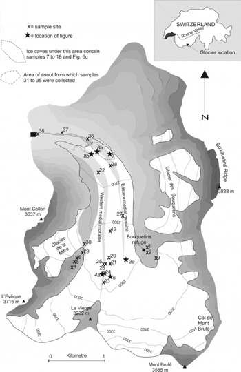
Fig. 1. Location map of Haut Glacier d’Arolla, showing place names mentioned in text, location of sediment sample sites and locations of photographs shown as subsequent figures.
There is a substantial literature covering many aspects of Haut Glacier d’Arolla, for example glacier geometry (Reference SharpSharp and others, 1993), subglacial hydrology (e.g. Reference Nienow, Sharp and WillisNienow and others, 1998), glacial meltwater chemistry (e.g. Reference Brown, Sharp and TranterBrown and others, 1996), interactions between glacier dynamics and hydrology (e.g. Reference Mair, Nienow, Willis and SharpMair and others, 2001), and the development of high-resolution glacier flow modelling (Reference Hubbard, Blatter, Nienow, Mairand and HubbardHubbard and others, 1998; Reference Hubbard, Hubbard, Maltman, Hubbard and HambreyHubbard and Hubbard, 2000). The formation of medial moraines and sediment transport pathways have also been described at the glacier (Reference Small, Clark and CawseSmall and others, 1979; Reference Gomez and SmallGomez and Small, 1985; Reference Small, Gurnell and ClarkSmall, 1987).
3. Methods
Structural mapping
The structure of Haut Glacier d’Arolla was determined by field and aerial photograph observations, from which a series of structural maps were produced. Field observations were made over three seasons between 1999 and 2001.
Sedimentary descriptions and clast analysis
Sedimentary descriptions were made in the field based on Reference HambreyHambrey’s (1994) modification of Reference MoncrieffMoncrieff’s (1989) nongenetic classification of poorly sorted sediments. Clast analysis is used to differentiate between sediment sources, transport histories and depositional environments in the glacial setting (Reference BoultonBoulton, 1978; Reference Benn and BallantyneBenn and Ballantyne, 1994). The approach used in this study is to compare samples of known transport or known depositional environments with samples of unknown or uncertain transport or depositional environments.
Thirty-eight sediment samples of 50 clasts each were collected from a variety of locations on and around Haut Glacier d’Arolla (Fig. 1) and classified into groups according to where the sample was collected. For each clast the following were recorded: (i) lithology, (ii) shape (relative lengths of the a (long) axis, b (intermediate) axis and c (short) axis), (iii) roundness (smoothness or angularity of the edges), and (iv) texture (surface roundness such as faceting and striations). Clast sizes were recorded using the Reference WentworthWentworth (1922) scale of grain-size. Clast roundness was estimated visually using the six roundness classes according to Reference KrumbeinKrumbein (1941) and Reference PowersPowers (1953). Clast data are presented in a modified RA/C40 plot (Reference Benn and BallantyneBenn and Ballantyne, 1994), which is a covariant plot of the RA index (modified in this study to be the percentage of very angular, angular and subangular clasts) and the C40 index (percentage of clasts with a c: a axial ratio of ≤ 0.4).
4. Summary of the Structural Evolution of Haut Glacier d’Arolla
Figure 2 demonstrates the structural evolution of the glacier in a simplified schematic form. The first event in the structural evolution of Haut Glacier d’Arolla is the deposition of snow, forming primary stratification in the upper glacier basin, which, following firnification, forms glacier ice (Fig. 2a). The upper basin is divided into subflow units according to where the ice originated. As the stratification moves down-glacier it becomes progressively folded, as a result of compression as the wide upper glacier feeds into a narrow tongue (Fig. 2b).

Fig. 2. Simplified structural evolution of Haut Glacier d’Arolla, showing the development of the key structures that are associated with debris entrainment, transport and deposition.
The glacier tongue is dominated by longitudinal foliation, which forms both from folding and eventual transposition of primary stratification, and any other structures formed in the upper reaches of the glacier (Fig. 2c). Also common in the glacier tongue are crevasse traces, which represent either the closure of open crevasses or the unopened continuation of crevasses. Crevasse traces rotate and become curved according to variations in velocity as they travel down the glacier tongue. At the snout of the glacier, some crevasse traces form stepped surfaces, which are interpreted as being reactivated thrust faults, resulting from longitudinal compression at the glacier snout (Fig. 2d).
5. Relationships between Debris Transport and Glacier Structures
Medial moraines
The medial moraines of Haut Glacier d’Arolla were investigated by Reference Small, Clark and CawseSmall and others (1979), Reference Gomez and SmallGomez and Small (1985) and Reference Small, Gurnell and ClarkSmall (1987) when the glacier was considerably larger. The observations made in this section are independent of this previous work, but comparisons are made in the discussion.
Haut Glacier d’Arolla has two main medial moraines: an eastern and a western (Fig. 1). The relationship between ice structure and medial moraine formation is different at each of the moraines. The point of emergence of the eastern medial moraine has moved up-glacier, in step with the rapid ablation and lowering of the surface of the glacier. The eastern medial moraine consists of a series of elliptical or V- shaped lenses, orientated roughly parallel to primary stratification and longitudinal foliation. At some locations, debris emerges along planes parallel to primary stratification (Fig. 3a). Debris in each lens is of a distinct lithology, a variety of either meta-pelite or meta-granite. The a axis of clasts emerging from the primary stratification tends to be parallel to fold axes measured along the plane of emergence (Fig. 3b). Once debris has emerged from the ice, it creates a variable debris cover ranging from ~20% to 100%. Down- glacier, the lenses become one joined-up mass, with denser debris cover creating an ice-cored ridge.

Fig. 3. Debris emerging to form the eastern medial moraine. (a) Debris emerging from primary stratification at the top of the glacier tongue to form one lens of the eastern medial moraine. Iceaxe right of centre for scale. Ice flow top left to bottom right. (b) Rose diagram displaying the a axis (long) orientation of clasts emerging in situ from the ice, forming one lens of the eastern moraine. The orientation of fold axes measured along the plane of emergence is 004°, dipping at 11° N. The a axis of the majority of clasts is orientated at a similar angle.
The western medial moraine is situated on the boundary between the main Haut Glacier d’Arolla flow unit and the La Vierge tributary glacier. In some places, the ice core of the western medial moraine is exposed by cross-cutting crevasses. Within the crevasse walls, steeply dipping foliated ice containing occasional debris-rich layers is exposed (Fig. 4a). The debris-rich layers vary in width from 30 to 1000 mm. Debris also emerges from less-steeply dipping (50-54° to east) debris-rich septa on the eastern margin of the western medial moraine. The a axis of clasts from within the debris- rich ice exposed in the medial moraine is parallel to the trace of the surrounding longitudinal foliation (Fig. 4a and b).

Fig. 4. Debris in the western medial moraine. (a) Two debris bands exposed by a crevasse cutting the western medial moraine. The long axis of many clasts is near-vertical, parallel to longitudinal foliation. Ice-axe for scale in centre of panel. Ice flow is into page. (b) Rose diagram displaying the a-axis (long) orientation of clasts emerging from foliation within the walls of a crevasse cutting the western moraine. The orientation of foliation measured within the crevasse is 170°, dipping at 72° W. The a axis of the majority of clasts is orientated at a similar angle.
Sediment samples were collected from the western and eastern medial moraines; they range from cobble-gravels to boulder-gravels and were dominated by clasts with high RA values (100%) and moderate to high C40 values (44-90%) (Fig. 5).

Fig. 5. Results of clast analysis from Haut Glacier d’Arolla, presented as RA/C40 plot. RA index has been modified in this study to be the percentage of very angular, angular and subangular clasts. Small numbers next to each data point correspond to sample numbers provided in Figure 1.
Crevasses and crevasse-traces debris
Crevasse traces, found near active crevasse fields near the top of the glacier, commonly (~80%) have debris associated with them (Fig. 6). In contrast, crevasse traces that have travelled a long distance from their source do not. The debris is brown or black clay, silt and sand. It has a high organic content with fragments of grass, moss, pine needles and leaves. The clay and silt commonly smells organic (foetid). Some deposits also contain angular to subangular rock fragments up to 5 mm in diameter, but insufficient gravelsized clasts for clast morphological analysis. Deposits are occasionally wider and deeper (up to 80mm) along some irregularly shaped crevasse traces with associated crystal quirks (ice structures representative of former englacial streams and moulins;Reference StenborgStenborg, 1968).

Fig. 6. A crevasse trace within an area of active crevassing picked out by a line of mud and silt. Ice flow is right to left.
Englacial debris layers
Within the walls and ceiling of ice caves at the snout of Haut Glacier d’Arolla are occasional discrete debris accumulations, termed englacial debris layers in this paper (Fig. 7). They are uncommon; fewer than ten were observed in each of the three field seasons between 1999 and 2001. Similar englacial debris layers are observable at the glacier surface, where they provide a source for dirt cones (see below).

Fig. 7. Englacial debris layers exposed in ice cave wall under snout of glacier. Thin debris layer concordant to foliation (two arrows) has been offset by a near-vertical, discordant debris layer (horizontal arrow). Offset direction indicated by small arrows. Ice flow is right to left.
Englacial debris layers vary from very thin (<10mm) dispersed silt and clay layers to ~0.5m thick. Their thickness varies along the length of the exposed layer, typically between 0.2 and 0.3m. All debris layers have a sharp boundary with the adjacent debris-free ice. The englacial debris layers usually extend for 5-20m, before disappearing into the roof of a cave or cave walls. The semitransparent nature of the ice indicates the layers continue within the ice, but at an angle to the ice cave wall. No debris layer was actually observed to start or finish; instead they change orientation or disappear into the debris-covered cave floor.
The material observed within the debris layers varies. It is always frozen with interstitial ice within the matrix. Some thin layers contain only clay, silt and fine sand, whilst thicker layers typically contain clast-rich intermediate diamicton. Englacial debris layers sometimes contain massive, unsorted sediments, whilst others contain bedded sedimentary sequences in which beds can be traced along the debris layer for ~1 m. Where a layer contains clasts within a finer matrix, the clasts show a strong fabric, parallel to the edges of the debris layers (i.e. perpendicular to debris layer strike). All sediment samples were clast-rich sandy diamicton with up to 10% faceted clasts and 2% striated clasts. Clasts were dominantly subangular and subrounded, with moderate to high RA values (24-74%) and low C40 values (22-32%), similar to samples collected from dirt cones and subglacial sediments (Fig. 5).
Dirt cones
‘Dirt cones’ are ice-cored, debris-mantled mounds formed by differential ablation rather than mechanical processes. In August 2001, ten main dirt cones were recognized at Haut Glacier d’Arolla (Fig. 8a and b), similar to the elongated ridges described on glaciers in Svalbard by Reference BoultonBoulton (1967), Greenland by Reference DrewryDrewry (1972), and Iceland and New Zealand by Reference Kirkbride and SpeddingKirkbride and Spedding (1996).

Fig. 8. Dirt cones near the snout of Haut Glacier d’Arolla. (a) Dirt cone with long axis trending parallel to ice flow, created from an englacial debris layer emerging parallel to longitudinal foliation. Ice flow into page. (b) The exposed ice core of a dirt cone. Ice flow right to left. Debris on the up-glacier (right) side of the dirt cone is frozen, and is fed by an englacial debris band which is concordant with local transverse foliation orientation.
The debris that forms dirt cones emerges as englacial debris layers from within the ice, either as wide sheets or linear trains of debris. Debris emerging in linear trains of sediment emerges roughly parallel to longitudinal foliation (Fig. 8a), whereas debris emerging in sheets emerges along reactivated crevasse traces (thrust faults) orientated perpendicular to the ice-movement direction (Fig. 8b).
Occasionally, bedded sedimentary sequences are exposed within the debris forming dirt cones. Five sediment samples were collected; all are sandy-pebble gravels with up to 26% faceted and 4% striated clasts. All samples had low to moderate RA values (0-38%) and low to moderate C40 values (6-44%) and plot close to glaciofluvial, subglacial and englacial sediments on a RA/C40 plot (Fig. 5).
6. Debris-Ice Structure Relationships: Interpretation
Medial moraine formation
The eastern medial moraine of Haut Glacier d’Arolla forms from rockfalls in the southeastern accumulation area of the glacier (Fig. 9). The distinct lithology (varieties of meta-pelite or meta-granite) of each lens suggests point sources for the rockfalls. Once buried in an englacial position, the debris is reorientated during the folding of the surrounding primary stratification in a manner similar to that proposed for polythermal glaciers in Svalbard (Reference Hambrey and GlasserHambrey and Glasser, 2003). In some cases, debris is exposed along a single limb of a fold within the open to isoclinal folding of primary stratification (Fig. 2a and b), or it may be exposed along both limbs of the fold, forming a V-shaped moraine (Fig. 9). The eastern moraine forms where it is because (1) it is fed by regular rockfalls from an area of relatively weak rock (the weathered contact between meta-pelites and meta-granites) which exists at Col de Mont Brule and (2) it marks the junction between two minor flow units (schematically represented in Fig. 2), where tighter folding concentrates the debris.

Fig. 9. Schematic summary of contemporary debris transport processes at Haut Glacier d’Arolla. Aerial view shows main inputs and transport processes occurring at the glacier surface. Cross-sections 1-3 summarize moraine formation. Cross-section 4 runs parallel to flow direction through the snout of the glacier.
Previous authors (Reference Small, Clark and CawseSmall and others, 1979; Reference Gomez and SmallGomez and Small, 1985; Reference Small, Gurnell and ClarkSmall, 1987) suggested that the eastern medial moraine is formed by the emergence of coarse angular clasts from a series of short longitudinal debris bands, identical to the debris emerging along planes of primary stratification described here. Introducing the concept of folding of rockfall-bearing primary stratification into the hypothesis of medial moraine formation explains the intermittent nature of the moraine lenses and the V-shape of some moraines (noted in Fig. 9 here and Fig. 2 in Reference Gomez and SmallGomez and Small, 1985).
The western medial moraine of Haut Glacier d’Arolla is interpreted as being directly fed from rockfall material from La Vierge, as well as internal rockfall-derived debris layers concentrated along this flow unit boundary as a result of tighter folding at the boundary (Fig. 9). Reference Gomez and SmallGomez and Small (1985) suggested that the western medial moraine is formed by direct rockfall from La Vierge and additionally nourished by two near-vertical englacial debris layers, in turn derived from rockfall and supraglacial clasts, which have been eroded along the side-wall/glacier interface. In contrast, Figure 9 explains the presence of multiple englacial debris layers that feed the western medial moraine, rather than just the two observed by Reference Gomez and SmallGomez and Small (1985). No evidence of the comminution of supraglacial clasts was observed during data collection for this study, so abrasion at the side- wall/ice interface (suggested by Reference Gomez and SmallGomez and Small, 1985) is not included in Figure 9.
Debris associated with crevasse traces
The high organic content of the debris associated with crevasse traces suggests the majority of this debris originates on the surface of the glacier. Debris may have been transported into open crevasses by the wind or surface meltwater. Once closed, crevasse traces create negative- relief features, which may act as a sediment trap for debris being washed or blown over the glacier surface.
Englacial debris layers
Two main hypotheses are suggested here for the origin of englacial debris layers at Haut Glacier d’Arolla. The first is that they are infilled englacial water channels. In this hypothesis, debris is transported by water between foliae (cf. Reference Kirkbride and SpeddingKirkbride and Spedding, 1996) or along thrust faults (cf. Reference Glasser, Bennett and HuddartGlasser and others, 1999). Sediment-rich water forces its way between foliae, forming englacial debris layers concordant with local foliation, and exploiting thrust faults or reactivated crevasse traces, creating englacial debris layers discordant to local foliation. Infilled foliation-parallel conduits crop out as linear trains of debris. In contrast, thrust faults may encourage sheet-flow of water and wide englacial debris layers.
Either water pressure must have been very high to allow up-slope propagation of water along structural weaknesses, or the discordant englacial debris layers have been subsequently back-tilted by compression since deposition, or a combination of the two. High water pressure may occurearly in the melt season, before the subglacial drainage system is fully developed and when the snout is still frozen to its bed. High basal water pressure is suggested by Reference Ensminger, Alley, Evenson, Lawson and LarsonEnsminger and others (2001) for the injection of turbid meltwaters into basal crevasses, forming laminated debris bands at Matanuska Glacier, Alaska, USA. An alternative mechanism is provided by Reference Kirkbride and SpeddingKirkbride and Spedding (1996) and Reference Spedding and EvansSpedding and Evans (2002), who have suggested that subglacial streams can become englacial when a subglacial deepening is present near the glacier snout. The presence of such an overdeepening near the snout of Haut Glacier d’Arolla, although small, was suggested by Reference SharpSharp and others (1993, Fig. 4).
The second hypothesis for the formation of englacial debris layers is that they are debris-laden thrust faults. This hypothesis requires that up-glacier ice overrides down- glacier ice via thrust faults, which also incorporates and transports basal sediments to a higher position. If thrusting has created the englacial debris layers, the bedded sedimentary sequences within the layers suggest unaltered subglacial sediment has been frozen-on and incorporated into the thrust in a manner similar to that described on polythermal glaciers in Svalbard (Reference Hambrey, Dowdeswell, Murray and PorterHambrey and others, 1996; Reference Murray, Gooch and StuartMurray and others, 1997) and on temperate glaciers in Chile (Reference Glasser and HambreyGlasser and Hambrey, 2002). However, thrusting does not explain the linear nature of debris layers emerging parallel to longitudinal foliation.
The similarity of sediment samples from englacial channels and subglacial sediments suggests that the former may be derived from the latter. Either hypothesis could account for the transport of subglacial clasts into an englacial position, and it is also possible that both processes operate in tandem.
Formation of dirt cones
The textural similarity between the sediment in englacial debris layers and the sediment forming dirt cones at Haut Glacier d’Arolla and the similarity in clast morphology (moderate to high RA values and low C40 values) (Fig. 5) suggests that the latter form as a result of differential ablation in locations where englacial debris layers crop out at the glacier surface. Englacial debris layers orientated parallel to longitudinal foliation form dirt cones with ridges orientated parallel to longitudinal foliation. In contrast, dirt cones fed by englacial debris layers emerging from thrust faults are elongated perpendicular to ice flow.
Clast morphology data (Fig. 5) indicate some dirt-cone samples have a similarity with glaciofluvial sediments whilst others are similar to subglacial sediments, further suggesting the englacial debris layers that form the dirt cones are polygenetic.
7. Conceptual Models of Debris Transport at Haut Glacier D’Arolla
The overall debris transport system at Haut Glacier d’Arolla is best summarized as a conceptual model. Hypothetical sediment inputs, sediments in transport, sediments being deposited and the reworking of sediments at Haut Glacier d’Arolla are summarized in Figure 9.
Cross-sections 1 and 2 (Fig. 9) summarize the formation of the eastern medial moraine at Haut Glacier d’Arolla. Rockfalls in the accumulation area are progressively folded within primary stratification as the glacier flows from a wide upper basin into a narrow tongue (cf. Reference Hambrey, Bennett, Dowdeswell, Glasser and HuddartHambrey and others, 1999). Ablation exposes the sections of folded medial moraine along the glacier tongue. Rockfall debris which has been folded along the limb of a fold is exposed as V- shaped moraines.
Cross-section 3 (Fig. 9) summarizes the formation of the western medial moraine at Haut Glacier d’Arolla. Direct rockfall from La Vierge is the main source of debris forming the moraine (cf. Reference Gomez and SmallGomez and Small, 1985). Rockfall debris which has been deformed within the ice is concentrated at the flow unit boundary between the main glacier tongue and the La Vierge tributary. Ablation along the glacier tongue exposes debris, which contributes to the increasing dimensions of the western medial moraine.
Cross-section 4 (Fig. 9) is a long-section of glacier snout, in particular displaying the relationship between dirt cones and surrounding ice structures, and the reworking of sediments by proglacial streams.
8. Conclusions
This study of the role of ice structures in debris transport at Haut Glacier d’Arolla has the following implications for other glaciers of similar morphology and thermal regime.
Ice deformation and associated ice structures play an important role in debris transport at Haut Glacier d’Arolla. For example, (i) medial moraines are strongly controlled by the folding of ice containing rockfall debris, (ii) debris accumulates in crevasses, which is later exposed along crevasse traces and (iii) dirt cones and englacial debris layers emerge from, or occur along, reactivated crevasse traces.
Previous conceptual models of the formation of medial moraines in temperate glaciers are developed significantly by the introduction of the folding of rockfall material within primary stratification. In particular, folding explains the multiple debris layers feeding the western medial moraine and the V-shape of some moraine lenses within the eastern medial moraine of Haut Glacier d’Arolla.
Dirt cones at Haut Glacier d’Arolla are formed by the differential ablation of englacial debris layers. Englacial debris layers are created when sediment-rich subglacial water under pressure forces a pathway through the ice, either concordantly between foliae, or discordantly along thrust faults (reactivated crevasse traces).
Acknowledgements
B. Goodsell gratefully acknowledges funding from The Leverhulme Trust whilst the manuscript was prepared. Fieldwork was undertaken whilst B. Goodsell was in receipt of a University of Wales, Aberystwyth, PhD studentship. The authors would like to thank several people for constructive comments at several stages of this paper: D. Benn, B. Hubbard, P. Knight, R. Naruse (Scientific Editor) and M. Truffer.


