


Introduction
Landscape characteristics are critical components of wildlife habitat and geographical analysis of such characteristics is an essential element in wildlife conservation (Jenness, Reference Jenness2007). Landscape topography influences the spatial distribution of wildlife (Kie et al., Reference Kie, Bowyer, Boroski, Nicholson and Loft2002; Boxall et al., Reference Boxall, Giannico and Li2008) and topographic characteristics are often used to analyse and assess habitat (Jenness, Reference Jenness2004). While the distribution of animals also depends on biotic factors, topography is a stable feature and can be used in initial assessments of habitat suitability and quality. The effect of patterns of abiotic factors on population and community dynamics is of great importance, especially given the number of species inhabiting patchy landscapes (Wiens, Reference Wiens, Hansson, Fahrig and Merriam1995; Tilman & Kareiva, Reference Tilman and Kareiva1997; Ricketts, Reference Ricketts2001). Developments in geographical information systems (GIS) are facilitating a greater application of spatial analysis to threatened species in cases where habitat patchiness and quality are key limiting factors, such as for the giant panda Ailuropoda melanoleuca (Ouyang et al., Reference Ouyang, Li, Liu, Liu, An and Zhang2002; Xiao et al., Reference Xiao, Ouyang, Zhu, Zhao, He and Wang2004), which is categorized as Endangered on the IUCN Red List (Lu et al., Reference Lü, Wang and Garshelis2008).
Drawing on the concept of elevational migrants Loucks et al. (Reference Loucks, Lü, Dinerstein, Wang, Fu and Wang2003) designed conservation landscapes for the giant panda throughout its stronghold, the Qinling Mountains in China. In a different region, the Qionglai Mountains, Xu et al. (Reference Xu, Ouyang, Andrés, Zheng, Liu and Xiao2006) used elevation and slope (elevation is strongly associated with giant panda activity; Liu & Jin, Reference Liu and Jin2008) to identify important linkage areas for giant panda management and conservation. While these and other studies have considered landscape topography to be a critical factor in habitat evaluation (Ouyang et al., Reference Ouyang, Li, Liu, Liu, An and Zhang2002), a theoretical framework for this relationship has not been developed and the extent to which topographic factors affect the distribution of the giant panda is unknown. Habitat suitability models based on topographic landscape features should be able provide a simplified assessment tool for giant panda conservationists and facilitate broader planning.
The giant panda occurs across six major mountain ranges in China: Qinling, Minshan, Qionglai, Liangshan, and Greater and Minor Xiangling Mountains (SFA, 2006). The Qinling Mountains provide critical high-quality habitat for giant pandas, characterized by steep high-altitude slopes and narrow catchments in the north and gentle low altitude slopes and broad open catchments in the south. This area supports a significant proportion of the remaining giant panda population (Pan et al., Reference Pan, Gao and Lü1988, Reference Pan, Lü, Zhu, Wang, Wang and Long2001; Hu, Reference Hu2001; SFA, 2006). Studying the relationship between suitable topographic landscape patterns and giant panda distribution in the Qinling Mountains will facilitate the development of a theoretical framework for studies of giant panda habitat quality and patterns of occurrence. Here, using GIS and statistical methods, we examine the effect of topographic landscape features on giant panda distribution across the species’ core habitat. We also assess the existing conservation network in this region and make proposals for optimizing this network to maximize conservation outcomes.
Study area
The Qinling Mountains are located in a transitional zone between the northern subtropical and warm temperate zones, form a watershed between the Yangtze and Yellow Rivers, and are also the source of several lesser tributaries. The highest peak is Taibai Mountain at 3,767 m. Three major roads running north-south are located in the east of the study area (national roads 108 and 210 and Xihan expressway). Our study area spans six counties in Shanxi province (Taibai, Zhouzhi, Ningshan, Foping, Yangxian and Liuba), covering an area of 614 km2, in which there were c. 271 giant pandas in 2001 (17% of the global wild population; SFA, 2006). This population comprises five subpopulations (Fig. 1): Pingheliang, Jinjiliang, Tianhuashan, Xinglongling-Taibaishan and Niuweihe (Sun et al., Reference Sun, Zhang and Jin2006). Thirteen nature reserves covering 365,228 ha and encompassing 88% of the Qinling Mountains' panda population (239 of 271 pandas in 2001) have been established to protect the giant panda and its habitat. This study site is also covered by the giant panda primary conservation network (Yan, Reference Yan2005; Sun, Reference Sun2007).

Fig. 1 The study area in Qinling Mountains, indicating the distribution of the giant panda Ailuropoda melanoleuca, the locations of the five subpopulations (names in yellow boxes), high quality topographic habitat patches, (see text for definition), occurrence and home range (see text for details) of giant pandas from the 2000–2001 survey (SFA, 2006; Sun, Reference Sun2007), reserves for the giant panda, and areas of suggested adjustment to the reserve network (see text for further details).
Methods
In the Qinling Mountains the giant panda shows a preference for habitat characterized by altitudes of 1,500–2,400 m, slopes of 0–30° and aspects of 67.5–292.5° (Pan et al., Reference Pan, Gao and Lü1988, Reference Pan, Lü, Zhu, Wang, Wang and Long2001; Ministry of Forestry & WWF, 1989; SFA, 2006; Sun, Reference Sun2007). We selected the range of these three features as representing high quality topographic habitat and using 1:50,000 WGS 84 UTM topographic maps from China’s National Fundamental Geographical Information Centre we created a digital elevation model, with a resolution of 30 × 30 m, for areas inhabited by the giant panda across the Qinling Mountains. Employing the three topographic landscape features we used the spatial analysis function of ArcView v. 3.2 (ESRI, Redlands, USA) to calculate and produce a GIS layer of this high quality topographic habitat.
The third and most recent survey of the giant panda was undertaken during 2000–2001, co-sponsored by China’s State Forestry Administration and WWF. The results from this survey were made available in 2004 and final reports published later (SFA, 2006; Sun, Reference Sun2007). Using giant panda occurrence data based on the longitude and latitude of the sightings, tracks, scats and den sites from this survey we were able to produce a GIS layer of the regional boundaries of areas inhabited by the five subpopulations. Giant pandas forage for 14 hours per day (Pan et al., Reference Pan, Lü, Zhu, Wang, Wang and Long2001) and therefore to create a realistic spatial representation of habitat used we overlaid on each panda occurrence point two circles, with radii of 411 and 1,839 m., respectively. Previous work has shown that giant pandas move on average 411 m and 0.53 km2 per day and have a yearly home range of 10.62 km2 (radius 1,839 m; Pan et al., Reference Pan, Lü, Zhu, Wang, Wang and Long2001). For comparative purposes we present analyses using both these measures of habitat use. Giant pandas are solitary animals and do not traverse large areas except during times of elevational migration. The 2000–2001 survey was conducted from November to June, while giant pandas were occupying altitudes of 1,000–2,100 m and not migrating (Pan, Reference Pan1995; Sun, Reference Sun2007). Therefore, the occurrence data used here are not skewed towards higher elevations and represent the broadest occurrence possible.
We overlaid the four GIS layers (high quality topographic habitat, panda occurrence data, daily movement range, yearly home range) to examine the relationships amongst these data. We then ran a canonical correlation analysis on the distribution pattern of high quality topographic habitat patches and giant panda occurrence; this is referred to as the correlation analysis method by Graeme (Reference Graeme2000). We used the Calculate Geometry function in ArcGis to calculate the longitude and latitude of the geometrical centres of every polygon of high quality topography within each giant panda’s annual home range. Using the point location occurrences of each giant panda we used SAS v. 9.1 (SAS Institute Inc., Cary, USA) to examine the correlation between the distribution of high quality topographic patches and presence of giant pandas by longitude and latitude. To determine the quality of the current reserve network Fragstats v. 3.3 (McGarigal & Marks, Reference McGarigal and Marks1995; Wu, Reference Wu2001) was used to calculate the following three landscape indices for high quality topographic patches within the area of each subpopulation and nature reserve: (1) patch density, as number of patches per 100 ha of the total area, (2) the area of the largest patch and its percentage of the total area of high quality topographic habitat, and (3) mean patch area.
Results
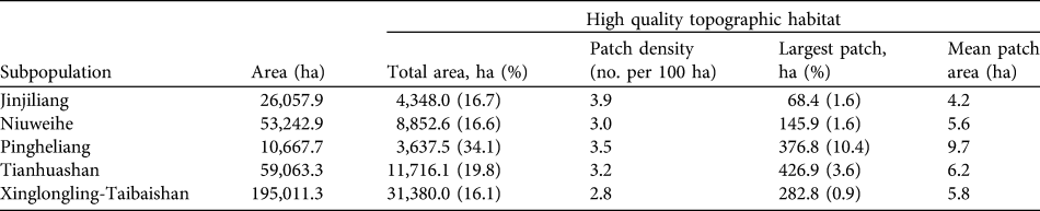
High quality topographic habitat for the giant panda in the Qinling Mountains was found to cover an area of 92,788 ha; i.e. 15% of the total area where giant pandas occur in these Mountains. The distribution of giant pandas closely follows the distribution of this high quality topographic habitat, and areas with a dense concentration of patches of suitable topography were strongly associated with areas of high giant panda density (Fig. 1). The five subpopulations inhabit 59,934 ha (65%) of the high quality topographic habitat. Of the five subpopulations Xinglongling-Taibaishan occupies the largest area of high quality habitat (31,380 ha), and Pingheliang the smallest (3,637 ha). However, Pingheliang has the largest mean patch area (9.7 ha) of high quality habitat and is the least fragmented subpopulation. The mean patch area of high quality habitat in the region of the Jinjiliang subpopulation is 4.2 ha and the largest patch is 68 ha, an indication that the area inhabited by this subpopulation is highly fragmented. Similarly the region of the Niuweihe subpopulation has a mean patch area of high quality habitat of 5.6 ha and the largest patch is 146 ha, and it is thus also highly fragmented (Table 1).
Table 1 The five subpopulations of the giant panda Ailuropoda melanoleuca in the Qinling Mountains (Fig. 1), with the area occupied by each and, for patches of high quality topographic habitat for the species (see text for definition), the total area (and percentage of area occupied by the subpopulation in parentheses), density, area of the largest patch (and percentage of the total area of high quality topographic habitat in parentheses), and mean area.
We found that 61% of giant panda occurrence records were within high quality topographic habitat, and that 91% (2,156 ha) of the daily range of giant pandas lay within high quality topographic habitat patches. The yearly home ranges contained a total of 22,578 ha of high quality topographic habitat. There was a significant positive correlation between the distribution pattern of high quality topographic habitat patches and the population of giant pandas (canonical correlation coefficients, ρ1 = 0.999; ρ2 = 0.995; P1 < 0.0001, P2 < 0.0001; Fig. 1).
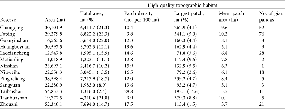
The current nature reserve network across the Qinling Mountains includes 51,782 ha of high quality topographic habitat; i.e. 56% of the total area and 14% of the total area of reserves. Because of other terrain features and reserve borders the distribution of suitable topographic habitat is uneven (Table 2). For example, the Foping, Changqing and Guanyingshan Reserves contain relatively high percentages of high quality topographic habitat (23, 21 and 22%, respectively) but the recently established reserves of Ninshan, Motianling and Sangyuan contain only 10, 11 and 9%, respectively, of high quality topographic habitat. There are also large differences in the mean patch size of high quality topographic habitat between reserves. Foping Reserve has a relatively high mean patch size (10.2 ha) and small patch density (9.8 patches per 100 ha) and has little fragmentation. In contrast, Taibaishan Reserve, with a mean patch size of high quality habitat of 3.5 ha and a high patch density of 28.8 patches per 100 ha, is highly fragmented (Table 2).
Table 2 The 13 giant panda reserves across the Qinling Mountains (Fig. 1), with the area of each and, for patches of high quality topographic habitat for the species (see text for definition), the total area (and its percentage of reserve area in parentheses), density, area of the largest patch (and percentage of the total area of high quality topographic habitat in parentheses) and mean area, and the number of giant pandas recorded in the 2000–2001 survey (SFA, 2006; Sun, Reference Sun2007).
Discussion
Habitat connectivity is of critical importance to population growth and recovery, genetic flow, and dispersal and migration (Hargrove et al., Reference Hargrove, Hoffman and Efroymson2004). Previous work has attributed the lack of a connection between the giant panda subpopulations of Niuweihe and Xinglongling-Taibaishan to agricultural development and human activity along the Xushui River (Ministry of Forestry & WWF, 1989; Pan et al., Reference Pan, Lü, Zhu, Wang, Wang and Long2001). However, our analysis shows that there is no high quality topographic habitat between these subpopulations and the lack of a connection may thus be the consequence of natural topographic barriers (Fig. 1).
The southern part of Laoxiancheng Reserve contains few patches of high quality topographic habitat but nevertheless supports a high density of giant pandas (14 pandas in 30 km2), six times greater than the average for the Qinling Mountains (7.8 giant pandas per 100 km2; Fig. 1; SFA, 2006). This may explain why more giant pandas have been invading the nearby village and more giant pandas have been injured and are in poor health in this area in recent years (Sohu, 2006a; WWF–China, 2007, 2008; Sohu, 2009). In contrast, large areas of high quality topographic habitat occur in the eastern Qinling Mountains (in the Guanyinshan and Tianhuashan Reserves) and along the Qinling Ridge (Fig. 1) but these areas support few giant pandas. This may be explained by habitat degradation as a result of logging and the construction of roads (Sun, Reference Sun2007).
The positive correlation between the availability of high quality topographic habitat and the occurrence of giant pandas (91% overlap when using daily range, 100% when using yearly home range) shows that suitable topography is important for giant pandas. Similarly, Loucks et al. (Reference Loucks, Lü, Dinerstein, Wang, Fu and Wang2003) found that areas with a greater number of patches of suitable topography, such as Foping and Changqing Reserves, are dense zones of giant panda habitat, whereas areas with fewer patches of high quality topography, such as the Xushui River catchment, have little high quality panda habitat. There is one discrepancy, however, between our study and that of Loucks et al. (Reference Loucks, Lü, Dinerstein, Wang, Fu and Wang2003): the classification of the area between the subpopulations of Xinglongling-Taibaishan and Tianhuashan. Despite being previously noted as an area without linkage between giant panda subpopulations (Fig. 1), we conclude that, with the availability of dense patches of high quality topographic habitat along Qinling Ridge, this zone should contain good habitat. Extensive bamboo restoration has taken place in this area in recent years following tunnel construction for the 108 national road, and giant panda tracks and scats are now frequently observed there (Sohu, 2006b). Again, this demonstrates that topography is an important component of giant panda habitat and, once other disturbances are removed, places with suitable topography can be quickly recolonized.
Of all the factors that affect the quality of giant panda habitat, topography is not normally subject to change. Given the role of topography in shaping habitat, landscapes containing ideal topographic features must be a critical consideration in reserve design. The existing system of nature reserves is too heavily weighted towards judicial and administrative boundaries, to the detriment of other factors. As a result, the giant panda conservation network may not fully support conservation goals. For example, whilst several reserves contain little high quality topographic habitat, several contain large areas of such topography. Moreover, some areas contain reasonable levels of high quality topographic habitat and play an important role in dispersal and migration of giant pandas but are not protected by the current reserve system. Some areas previously identified as corridors or sites for linkage, are, according to our analysis, not necessarily of conservation value. Areas such as Erlangba, a section of the 108 national road in Qinling Ridge, Dashuping, Houzhenzi, Longcaoping, Jiuchihe and Caiziping, have been designated as suitable corridor habitat (Fig. 1; Ministry of Forestry & WWF, 1989; Loucks et al., Reference Loucks, Lü, Dinerstein, Wang, Fu and Wang2003; WWF–China & Academy of Forest Inventory and Planning of Shanxi Province, 2005) but, except for Dashuping, Houzhenzi and Qinling Ridge, no other site contains high quality topographic habitat.
Our findings facilitate a better understanding of giant panda population patterns across the Qinling Mountains. Based on our analysis we believe that conservation of the giant panda needs to have an increased focus on areas with high quality topographic habitat for the species, and we therefore make several recommendations: (1) With little high quality topographic habitat in Sangyuan Reserve, Niuweihe and Sangyuan Reserves should be combined into a single reserve. (2) Tianhuashan Reserve should be extended to cover the patches of suitable topography that lie to the west of the Reserve. (3) Containing poor high quality topographic habitat and only one giant panda, Ninshan Reserve should be treated as a important corridor between the Jinjiliang and Pingheling subpopulations. (4) Three localities that are not included in the protected network, namely Dashuping between the Niuweihe and Xinglongling-Taibaishan subpopulations, Jinjiliang between the Tianhuashan and Jinjiliang subpopulations, and Houzhenzi, with three neighbouring Reserves (Taibaishan, Laoxiancheng and Zhouzhi), should be protected as important linkage zones that could facilitate dispersal and genetic flow. (5) Disturbances from transportation, hydropower development, livestock grazing, collection of herbs and tourism in the eastern part of the study area, particularly in Guanyinshan and Tianhuashan Reserves, should be restricted. (6) The monitoring programme for the giant panda in the southern part of Laoxiancheng Reserve, where high quality topographic habitat is limited, should be modified to increase the frequency of surveillance and detection, and contingency plans should be put in place to cope with potential issues such as bamboo flowering events and disease epidemics.
Our findings and recommendations are being used in the giant panda conservation programme. For example, Houzhenzi has been listed as a pilot project in a giant panda corridor programme sponsored by WWF and the local government, and the area of Jinjiliang will be included in the giant panda reserve network in the Qinling Mountains by establishing a new reserve. In addition, giant panda habitat is being restored in the eastern part of Qinling Mountains by control of disturbance and planting of bamboo. Although there is as yet no emergency plan for the giant panda the construction of an emergency rescue system for giant pandas was incorporated into the giant panda conservation plan for 2010–2020 by the State Forestry Administration.
Acknowledgements
We thank Fan Zhiyong, Director of the species department at WWF–China for providing instruction during our study, and Tao Yi, Qi Dunwu, Zhang Hongmao, Zhang Jiahua and Zhang Wei for feedback and assistance. This study was funded by WWF–China (CN0892) and supported by the State Forestry Administration of China. We are grateful to Chai Wansuo and Zeidae for editing this article.
Biographical sketches
Ming-Hao Gong has been studying the giant panda and its conservation for many years and is responsible for reserve design and the implementation of management plans. Yan-Ling Song’s research interests focus on the conservation of threatened wildlife, behaviour and animal ecology. Her research group has undertaken projects on threatened deer, takin and the giant panda.


