


Introduction
The intrinsic value of nineteenth and early twentieth century search reports to understanding the archeological record of the 1845 Franklin northwest passage expedition and to better correlate data with confirmed or hypothesized events is indisputable. First-person narratives of search expeditions and of Inuit oral history continue to figure prominently in reconstructions of events, but their usefulness in identifying and explaining the expedition’s archeological record is not a straightforward exercise and can lead to confusion rather than clarity. Site coordinate data recorded by early Franklin searchers, for example, are an important consideration in designing archeological surveys but its utility is limited due to susceptibility to familiar but nevertheless significant error, particularly coordinates for longitude. Complications arising from incorrect locational data are amplified by the provisional nature of maps based on them, by the generally flat landscapes of King William Island and Adelaide Peninsula, and by the fact that many of the reported sites had been altered by multiple episodes and types of disturbance. Limiting factors such as these are common where historical narratives inform archeological research, and they are hardly unique to archeological investigations of the 1845 Franklin expedition. The use of historical records pertaining to the Franklin expedition is often complicated, however, by their assumed reliability which can impede efforts to incorporate archeological perspectives particularly those that challenge reconstructions derived primarily from historical accounts (Stenton & Park, Reference Stenton and Park2017).
New investigations of the archeological record of the 1845 Franklin expedition’s presence on King William Island and Adelaide Peninsula commenced in 2008 with a focus on previously examined but often inadequately documented sites and on renewed searches for sites identified and interpreted primarily through historical lenses. In this paper, two sites on King William Island in the latter category are presented as a case study of factors contributing to the misidentification and misinterpretation of a historically familiar but archeologically obscure Franklin expedition site on King William Island.
Discoveries made on the west coast of King William Island by the 1859 Franklin search expedition led by Francis Leopold McClintock provided the first detailed intelligence concerning the fate of the 1845 Franklin expedition (McClintock, Reference McClintock1859b). These finds have been the subject of numerous studies, and the focus of this paper is a re-examination of McClintock’s sole Franklin expedition discovery on the south coast of the island – a human skeleton and a small collection of associated artifacts. Analyses of this find have endeavored to identify the individual by correlating biographical and other data contained in naval records with the artifactual evidence, specifically, clothing fragments and the contents of papers contained in a pocketbook found with the skeleton. The sailor’s identity has never been positively ascertained but it is generally believed that the initial attribution of the remains to Henry Peter (“Harry”) Peglar, Captain of the Foretop, HMS Terror (McClintock, Reference McClintock1869) was incorrect and that two more plausible candidates are Thomas Armitage (Gunroom Steward) and William Gibson (Subordinate Officers’ Steward), both of whom also served on HMS Terror and were known to Peglar through previous service on other ships (Cyriax & Jones, Reference Cyriax and Jones1954; Jones, Reference Jones1984; Stein, Reference Stein2007). Nevertheless, in the Franklin expedition literature the site continues to be known colloquially as the “Peglar” skeleton.
Interest in the Peglar site emerged from archeological investigations conducted in 2019 at a site where a disturbed grave containing a partial human skeleton was found in 1973. That site, NdLe-16, had a brief but interesting investigative history resulting in the attribution of the skeletal remains to a member of the 1845 Franklin expedition. For reasons that will be explained, it is not a particularly well-known site, but re-examination of historical records and new archeological evidence reveal that it is the Peglar site. This paper explains the basis for the confusion about the site’s identification and corrects interpretive errors made in 1859 and in 1973.
1857–59 McClintock Franklin Search Expedition
The most familiar source of information concerning the discovery of the Peglar skeleton is the various editions of “The Voyage of the ‘Fox’,” McClintock’s narrative of his 1857–59 Franklin search first published in 1859 (McClintock, Reference McClintock1859b). Occasionally cited, but generally less well-known, is the account published in Danish by his interpreter Carl Petersen (Petersen, Reference Petersen1860). A third source is McClintock’s sledge journal for the period of April – June 1859 (McClintock, Reference McClintock1859a). All these sources have been consulted in the present study, with particular emphasis on McClintock’s journal which contains information as recorded during the search (i.e. unedited for publication). To provide a framework for the discussion that follows, data contained in McClintock’s journal have been summarized and cross-referenced with his and Petersen’s published accounts. The journal was written in pencil, and some words are faded and difficult to read, but the sections pertaining to the discovery of the Peglar skeleton are sufficiently legible to enable reconstruction of the events that occurred during the period in question.
McClintock’s search strategy involved travel during the evening, typically setting out between 6:30 and 7:30 PM and usually stopping to camp the following morning between 5:00 and 6:00 AM. Miles were occasionally denoted using an apostrophe (e.g. 5’), and distances traveled were recorded to within a mile or less (e.g. 15 – 16 miles; 4½ – 5 miles). In the discussion that follows, distances recorded by McClintock in geographical miles (essentially equivalent to nautical miles; McClintock, Reference McClintock1859b, p. 226) are shown in parentheses, and for the period of 23–26 May, during which the Peglar skeleton was found, his rate of travel along the search route averaged 3.3 km (1.8 miles) per hour (Table 1).
Table 1. Summary of McClintock’s travel along Simpson Strait of King William Island, 23–26 May 1859.

a Travel time reduced by 1.5 hours for examination and rebuilding of two stone cairns.
b Travel time reduced by 2 hours for examination and burial of skeleton.
A synopsis of the published version of the discovery of the Peglar skeleton is as follows: it was found by McClintock, shortly after midnight of 25 May 1859, on the south coast of King William Island, on a snow-covered gravel ridge east of Cape John Herschel. The skeleton was face down, and small animals had gnawed and, in some cases, dissevered limb bones. Fragments of clothing and a few personal items surrounded the skeleton (McClintock, Reference McClintock1859b, pp. 274–275). McClintock recorded the location of the skeleton as 16.7 km (9 miles) east of Cape John Herschel and on the map of the McClintock search expedition published in 1859; it is shown as about midway between Cape John Herschel and Gladman Point.
McClintock maintained detailed records of his expedition including navigational observations, times, and estimated distances traveled, and there is no reason to question these details of his account of the discovery of the Peglar skeleton. Accordingly, archeological surveys intended to relocate the site for further investigation would logically be conducted along the shoreline between the two named landmarks (Stenton, Reference Stenton2018). This area was surveyed in 1981 but the Peglar site was not found (Beattie, Reference Beattie1981). Given its described characteristics and the passing of more than a century, the skeleton could easily have been overlooked in 1981 or in subsequent searches, but the reason that no evidence of it was found is because it is not located there. McClintock described the site as being 9 miles east of Cape John Herschel and west of Gladman Point, just as it was shown on the expedition map prepared by John Arrowsmith which McClintock had undoubtedly reviewed and validated. The point-to-point distance between Cape John Herschel and Gladman Point, however, is 14 km (7.5 miles) meaning that the Peglar skeleton could not simultaneously have been 9 miles east of Cape John Herschel and west of Gladman Point. A simple explanation for the apparent contradiction is the understandable imprecision of the 1859 Arrowsmith map. Arrowsmith was a prominent mapmaker (Skurnik, Reference Skurnik2020), and his chart of the 1857–59 McClintock search expedition is an important reference document. On the map, the distance between Cape John Herschel and Gladman Point is approximately 24 km (13 miles) (Fig. 1), about the same distance shown between them on the 1843 map of the Dease and Simpson expedition, also prepared by Arrowsmith. On James Wyld’s c. 1859 map of McClintock’s expedition, the distance is roughly 37 km (20 miles), and on Gould’s 1927 map, it is about 22 km (12 miles). Thus, the apparent geographical contradiction between the site’s location as described and as mapped can be explained as a reflection of a lack of accurate cartographic data resulting in all the maps unintentionally exaggerating the distance between the two landmarks.

Fig. 1. Excerpt from Arrowsmith’s 1859 map of McClintock expedition showing the locations of Gladman Point, Cape Herschel, and the place where the Peglar skeleton was found.
Mapping inaccuracies do not explain, however, why McClintock referenced the location of the skeleton relative to Cape John Herschel rather than to Gladman Point which, based on the maps, was arguably as near to it as was Cape John Herschel. Moreover, the chronology of McClintock’s search narrative includes the discovery, prior to finding the skeleton, of a large stone cairn west of Gladman Point. He referenced the location of the cairn relative to Gladman Point but chose Cape John Herschel as the geographic referent for the location of the skeleton. The explanation for this decision, a seemingly inconsequential matter but one having implications for archeological investigation of the Peglar site, is found in McClintock’s journal.
“Fox” Journal of Sledge Journey April – June 1859
23–24 May
On Monday, 23 May 1859, McClintock was returning from a search of Montreal Island and environs and was camped on the ice off the north shore of Adelaide Peninsula near an outer island in Barrow Inlet. At 7:00 PM, his party broke camp and sledged north across Simpson Strait to the south coast of King William Island. They reached the island just over seven hours later at 2:15 AM, having traveled 25 – 26 km (13½ – 14 miles). Their point of landfall was described as a little stony point a short distance west of the Peffer River. The specific reference to the Peffer River suggests McClintock was describing the small point of land located 1.5 km west of the mouth of the river. From there, they continued north-northwest another 8 – 9 km (4½ – 5 miles) and encamped at 5:00 AM on 24 May (McClintock, Reference McClintock1859a, Monday 23 May). The exact location of the 24 May camp is unknown but has been approximated based on the estimated distance traveled of 34 km (18.5 miles) (Table 1; Fig. 2).

Fig. 2. McClintock survey route of 23–26 May 1859 as reconstructed from his journal of April – June 1859. The location of the Peglar skeleton has been approximated using the 1859 Arrowsmith map.
24–25 May
Retracing McClintock’s movements over the next two days is more difficult, but they have been extrapolated by correlating dates, times, and distance intervals with the encampments which were the endpoints of the daily surveys. On Tuesday, 24 May, he set out at 6:40 PM and just over ten hours later camped on the ice at 4:50 AM of 25 May. After factoring in an unplanned detour inland, McClintock estimated that they had advanced no more than 28 or 30 km (15 or 16 miles). Just over 5 km (3 miles) into the trip, they reached a river and upon a hill on its west bank found an abandoned snow house and “an unusually conspicuous native cairn” which was dismantled and the ground beneath it examined (Petersen, Reference Petersen1860, p. 194).
Other details for this leg of the journey are less easily reconstructed as places located along the route that would help to plot the course and timing more precisely, such as Douglas Bay and Tulloch Point, are not mentioned. It is also not clear if the search included roughly 11 km (6 miles) of shoreline of inner Douglas Bay. An 11:40 PM journal entry noted that the coast turned up greatly to the north-northwest for a short distance, as does the eastern shoreline of the mouth of Douglas Bay, but an hour later, at 12:50 AM, they had crossed a small bay and reached a point of land 3.7 km (2 miles) to the west. The 12:50 AM journal entry is consistent with the estimated rate of travel (i.e. traveling about 3.7 km (2 miles) in just over one hour) but it is not clear if Douglas Bay was the small bay described. It presumably was and McClintock might have characterized it as such and not surveyed its shoreline due to difficulty in distinguishing land from sea. His second in command, Lt. William Hobson, who at the time was searching the west coast of King William Island, periodically faced this same challenge (Hobson, Reference Hobson1859; Stenton, Reference Stenton2014, p. 516), and McClintock attributed the unintended detour of several miles inland earlier in the evening specifically to the same issue: “We got inland when trying to proceed further, land and ice being uniformly covered with snow, the former devoid of elevation or any remarkable feature” (McClintock, Reference McClintock1859a, Tuesday 24 May).
The most confusing detail in McClintock’s journal entry for 24 May is his belief that he had reached Gladman Point: “12:50 AM of Wednesday 25th reached another little point having marched due west for 2 miles across a small bay (Pt. Gladman)” (McClintock, Reference McClintock1859a, Tuesday 24 May). Based on the time recorded, McClintock’s position at 12:50 AM would have been about 30 km (16 miles) southeast of Gladman Point and four hours and roughly 13 km (7 miles) southeast of where he eventually camped in the morning of 25 May. A possible explanation is that he had reached Tulloch Point, or one nearby, and unintentionally recorded it as Gladman Point but his description of the next landmark confirms his geographical error. Just over three hours later at 4:00 AM, he reached the next point of land, described as being of somewhat higher elevation and having a small bay on its east side. Here, McClintock reported finding another prominent and well-built cairn and that his position was west of Gladman Point: “Upon a conspicuous point, to the westward of Point Gladman, a cairn nearly five feet high was seen, which, although it did not appear to be a recent construction, was taken down, stone by stone, and carefully examined, the ground beneath being broken up with the pickaxe, but nothing was covered.” (McClintock, Reference McClintock1859b, p. 273).
Petersen’s account concurs with the key points of McClintock’s version including the discoveries and the investigations of the two cairns, but he did not reference their locations relative to known or otherwise identifiable landmarks (Petersen, Reference Petersen1860, pp. 195–196). Based on the times recorded, the second cairn was probably located at or near Peabody Point. Between 12:50 AM and 4:00 AM, they would have traveled about 10 km (5.4 miles) placing them in the vicinity of Peabody Point which has a small bay on its east side. The large stone cairn was completely dismantled and rebuilt after which they moved on and encamped. The brief amount of time (50 min) between finding, dismantling, and rebuilding the cairn and stopping to set up their next camp suggests that the cairn was examined expeditiously and that the camp was established a short distance from it. A hypothetical 29 km (15.5 miles) course from the presumed 24 May encampment, excluding inner Douglas Bay, would situate the 25 May camp just west of Peabody Point (Fig. 2).
25–26 May
McClintock recorded the time of departure from the 25 May camp as 7:15 PM, and Petersen (Reference Petersen1860, p.195) reported it as 7:30 PM. After marching approximately 9 km (5 miles), he described reaching a point of land to the east-southeast of which was an island 2.8 km (1.5 miles) offshore and 1.9 km (1 miles) long. From the description, this would appear to be Eta Island, which is roughly 1.9 km in length, although only half the distance offshore from the point where McClintock presumably described it. They traveled a total of 30 km (16 miles) in just over 10 hours and camped on the ice at 5:40 AM of 26 May. The location of this camp was recorded on a small map sketched in McClintock’s journal, and its position was described in detail: “Our encampment is 2’ from the peninsula point & within ¼th of a mile of the land and 4½ or 5 miles from C. Herschel” (McClintock, Reference McClintock1859a, Wednesday 26 May). The sketch map is reproduced in Fig. 3 and shows the locations of the 26 May and 27 May camps, the approximate distances between them, McClintock’s sledging route, and Cape John Herschel. The “peninsula point” 2 miles from the 26 May camp is unquestionably Gladman Point which McClintock had mistakenly placed about 30 km to the southeast. This explains why he reported the location of the large cairn as being west of Gladman Point and the location of the Peglar skeleton as east of Cape John Herschel – in both cases, he thought they were the nearest named landmarks.

Fig. 3. Left: McClintock’s sketch map showing the location of his 26 May camp west of Gladman Point, and the course of his 26 – 27 May sledge route. Right: McClintock’s map redrawn from his 1859 sketch. Bottom: Key locations from McClintock sketch map plotted on topographic map 67A, Simpson Strait.
The Peglar skeleton
The singular discovery event during the 25–26 May search was the sailor’s skeleton (Fig. 4) which, given the snow conditions, McClintock described as “an extraordinary piece of good fortune” (McClintock, Reference McClintock1859a, Wednesday 25 May). The time of the discovery is not recorded in McClintock’s journal, but in published accounts, it was said to be shortly after midnight of 25 May, making the actual date of the discovery 26 May.

Fig. 4. Artist’s renditions of McClintock’s discovery of the “Peglar” skeleton on 26 May 1859. (l): Illustrated Times, 19 October 1859, depicting the body in the supine position; (r): Die Franklin-Expedition und ihr Ausgang, (Wagner, Reference Wagner1861), showing the body in the prone position. McClintock reported that only a portion of the skull was visible through the snow and that the body was found in the prone position. (Images Courtesy Logan Zachary Collection).
Petersen (Reference Petersen1860, p. 195) described the time of the event as “sometime around midnight.” McClintock’s journal reveals that the Peglar site was not located where it had been reported and mapped, but it contains information that can be used to approximate its correct location. Using 12:15 AM on 26 May as an estimate for the time of the discovery, the skeleton would have been found 5 hours and 25 minutes prior to McClintock stopping to camp at 5:40 AM. At the estimated rate of travel, the skeleton would have been situated about 18.5 km (10 miles) from the 26 May campsite, but McClintock reported it as being about that same distance (9 miles) from Cape John Herschel, which was 8 to 9 km (4½ to 5 miles) northwest of the 26 May camp. In attempting to approximate where the skeleton was found, two variables affecting time and distance records must be considered. First, McClintock was not traveling during the entire ten-hour period, and the Peglar site was the only place on that day’s search where he stopped for any length of time. How much time was spent examining the skeleton is not stated but the following day at Cape John Herschel he spent one and a half hours examining the Simpson cairn in an unsuccessful search for a Franklin expedition record (McClintock, Reference McClintock1859a, Thursday 26 May). It is conceivable that an equal, if not greater amount of time, was spent examining the skeleton of a member of the expedition, and if a minimum of two hours is allowed for the multiple interventions that occurred, the travel time to the 26 May campsite would be reduced to 3 hours and 25 minutes which converts to a distance of about 11 km (6 miles).
The second consideration is differentiating distances recorded as point-to-point from those of the indirect and longer sledge route. McClintock’s journal described the route taken from the Peglar site to the 26 May camp as northwest along the shoreline, a short distance into what is now McClintock Bay, around what is now Hobson Island to Gladman Point, and then northwest along the shoreline to the site of the camp. A hypothetical route plotted between the two locations using this description would be approximately 10 km (5.5 miles) long. On his sketch map, however, McClintock referenced key locations using point-to-point distances which presumably also applied to the distance between Cape John Herschel and the Peglar skeleton. Thus, if the 26 May camp was roughly equidistant between the Peglar site and Cape John Herschel, the skeleton must have been situated 8 – 9 km (4½ – 5 miles) southeast of the 26 May camp. Using the tip of Gladman Point as an unambiguous landmark in McClintock’s description and subtracting the distance between it and the 26 May camp (3.7 km; 2 miles) would place the Peglar site approximately 4.6 – 5.6 km (2.5 – 3 miles) southeast of the tip of Gladman Point.
McClintock provided few other particulars about the location of the skeleton, but Petersen (Reference Petersen1860, p. 195) recorded two crucially important details. The first was the presence of a rock behind the skeleton. He gave no indication of its size, but it apparently was large enough for him to have not only remarked on it, but to also speculate that the man might have sat on the rock to rest and then fell face down as he attempted to stand up. McClintock described clearing away the snow within a radius of 2 – 3 m (8 – 10 ft) around the skeleton, but he did not mention the rock in his journal or in his published account of the discovery. The second detail recorded by Petersen was that after examining the site the bones, presumably meaning those disarticulated by animals, were gathered with the rest of the skeleton and covered with rocks. This is significant for two reasons: it reveals the existence at the site of a makeshift grave, a potentially identifiable archeological feature, and because no other description about the way the bones were treated prior to departing the site has been found in other accounts of the expedition, including McClintock’s journal.
Description of skeletal remains
McClintock described the skeleton as “perfectly bleached,” lying face down, and with the limbs and the smaller bones “either dissevered or gnawed away by foxes” (McClintock, Reference McClintock1859a, Thursday 26 May; McClintock, Reference McClintock1859b, p. 274). Petersen remarked that “based on how the skeleton was positioned, it seemed that the person had fallen right on his face” (Petersen, Reference Petersen1860, p. 195). None of the documents specify the criteria on which the body was determined to be in the prone position, and it is not clear from either comment if the orientation of the cranium was being described. Both statements are also difficult to evaluate due to uncertainty about McClintock’s and, Petersen’s level of familiarity with human skeletal anatomy, the positional integrity of other parts of the skeleton given that some limb bones had been disarticulated by animals, and a lack of detail about how thoroughly the snow covering the skeleton had been removed. Some parts of the skeleton were conceivably frozen to the ground and apart from the gathering of the disarticulated limb bones the reports contain no mention of any attempt to move the skeleton to facilitate its examination or burial. The recovery contexts of some of the clothing fragments relative to parts of the skeleton might have indicated the position of the body, but Petersen characterized them as “only a few rags scattered around the skeleton in different directions” (Petersen, Reference Petersen1860, p. 195), and McClintock described the clothes as having been “torn to atoms.” These remarks suggest it is unlikely that clothing was a factor in determining or confirming the position of the skeleton. Identifying the position of a largely intact skeleton laying on the ground would seem to be a straightforward exercise, and there is no obvious reason to question the official report. However, as will be discussed, this detail has a bearing on the identification of the Peglar burial site.
Artifacts
The published list of artifacts found with the skeleton was a leather pocketbook containing several papers, a pocket comb, a clothes brush, two coins, two silk-covered great-coat buttons, fragments of a cotton shirt and neckerchief, and pieces of a blue double-breasted waistcoat or jacket with silk-covered buttons (McClintock, Reference McClintock1859b, p. 371). McClintock (Reference McClintock1859b, p. 274) stated that “every scrap of clothing was gathered up” but it is not clear what happened to all of them. His journal lists clothing fragments not itemized in the published account including trousers, a woolen comforter, mitts, drawers, and two pairs of stockings (McClintock, Reference McClintock1859a, Thursday 26 May; Cyriax, Reference Cyriax1939, p. 171). The National Maritime Museum lists only the neckerchief, two coat buttons, the shirt fragment, and a piece of the waistcoat with four attached buttons (Walpole, Reference Walpole and Potter2017). Interestingly, McClintock’s inventory of the clothing found with the skeleton did not include footwear.
To summarize, a review of published and unpublished historical records of McClintock’s sledge journey along the south coast of King William Island between 23 and 26 May 1859 provides important new details about the discovery of the Peglar skeleton. Most significantly, it reveals that McClintock made a previously undetected geographical error about the location of Gladman Point that would result in the location of the Peglar site being incorrectly described, mapped, and interpreted for over 160 years.
Exercise Northern Quest – Franklin Search, July 1973
Exercise Northern Quest was a volunteer military training exercise conducted on King William Island in July 1973. It involved twenty-three members of the 1st Battalion, Royal Canadian Regiment (1RCR), CFB London, and two representatives from the Defence and Civil Institute of Environmental Medicine. The purpose of the exercise was twofold: to provide training and skill development in a challenging physical environment and to acquire new information concerning the fate of the 1845 Franklin northwest passage expedition (Walsh, Reference Walsh1973).
Operating from a base camp established on 10 July at Gladman Point, sixteen of the participants organized into three search teams that over a ten-day period conducted reconnaissance of approximately 200 km of the south coast of King William Island between Todd Island and Terror Bay, and a small section of shoreline of northern Adelaide Peninsula. Each team was assigned to one of three search areas: Gladman Point – Terror Bay, Gladman Point – Tulloch Point, and Douglas Bay – Todd Island. In preparation for the exercise and to assist searchers, a guide booklet was assembled that included an annotated map showing the locations where discoveries had been made in the nineteenth and early twentieth century. The guide map and a subsequent annotated topographic map of Simpson Strait (67A) showing discoveries made by the 1RCR reproduced the location of the Peglar skeleton as shown on the 1859 Arrowsmith map and labeled as a “19th Century Finding” (Fig. 5).

Fig. 5. Excerpt from 1RCR annotated topographic map showing the place where the skeleton was found in 1973. The red stars indicate discoveries made in the nineteenth century. The second star to the left of the 1RCR flag is location of the Peglar skeleton as recorded in 1859. (Source: Walsh, Reference Walsh1973).
Inuit and European artifacts were found in all the survey areas, but the highlight was the 16 July discovery by the Gladman Point – Tulloch Point team of a disturbed human grave next to a large boulder on the shore southeast of Gladman Point (Fig. 6). The search team was drawn to the grave, which they examined over several days, by bleached bones protruding from it. Removal of the rocks and several inches of moss revealed a human skeleton, largely complete, but minus the cranium (Walsh, Reference Walsh1973, Search Day Five, 16 July 1973). The following day, the bones were removed from the grave and the skeleton was partially reassembled on a sheet of plywood. During that process, two buttons were found among the bones. On 19 July, a cairn commemorating Exercise Northern Quest was erected ten yards from the grave, and additional bones, teeth, and buttons were recovered by sifting the soil removed from the grave through a makeshift screen. The bones and artifacts were collected, and Exercise Northern Quest personnel re-deployed to London on 26 July. The collections made by the search teams were sent to the National Museum of Man in Ottawa (now the Canadian Museum of History) for expert examination and care. Following their arrival at the museum, their fate would become something of a mystery.

Fig. 6. Map of south-central King William Island showing the location of NdLe-16 relative to the recorded location of the Peglar skeleton.
In a letter dated 5 November 1973, Brigadier-General J. A. Fulton, Commander, Canadian Forces Northern Region confirmed for the Commanding Officer of the First Battalion Royal Canadian Regiment that the National Museum of Man had received the collections for identification and safekeeping. Unfortunately, no records have been found at the Canadian Museum of History concerning the inventory or the analyses performed on the human bones and artifacts received from the 1RCR. Fulton’s letter included a quote, however, from separate correspondence received from William E. Taylor Jr., Director of the National Museum of Man. The wording of the quote implied that the grave contained the remains of a member of the 1845 Franklin expedition: “The material collected this summer will add, I am sure, to the data already existing and lead, hopefully, one day to an understanding of the events involved in the demise of the Franklin expedition.” (Walsh, Reference Walsh1973, J. A. Fulton Correspondence).
The results of Exercise Northern Quest were published in Pro Patria/Connecting File (Bentley, Reference Bentley1973), in the February 1974 edition of Canadian Motorist (Pyragius, Reference Pyragius1974), and in the 1974/5 edition of Sentinel, the magazine of the Canadian Forces (Walsh, Reference Walsh1974/5). In the Pro Patria/Connecting File and Canadian Motorist articles, the skeletal remains were described as having been transferred to and undergoing analysis at the National Museum of Man. In the Sentinel article, they were described as having been “identified as European of about the period (125 years ago) of the missing explorers” (Walsh, Reference Walsh1974/5, p. 24).
Examination at the National Museum of Man of the human skeleton and associated artifacts found by the 1RCR was unquestionably conducted by experts, but their identities are unknown, and because no cranium was found, the morphology of which at that time would have been used to assess ancestry (J. Cybulski, personal communication, 23 May 2020), it is not clear how the individual’s ancestry and attribution to the Franklin expedition were established. The identification might have been based on diagnostic attributes of the associated artifacts, but if so, they were not described in any detail in the published accounts. The absence of the analysis records is compounded by the unfortunate circumstance that the 1973 skeletal and artifact assemblages from NdLe-16 have been missing for decades, and their location is listed as unknown in the records at the Canadian Museum of History (S. Girling-Christie, personal communication, 24 October 2019).
Skeletal remains
An inventory of the skeletal remains received by the National Museum of Man in 1973 is not available, but one in situ and one post-excavation photograph of the skeleton confirm that substantial portions of the axial and appendicular skeleton were recovered (Fig. 7). The cranium was not found, but the mandible, several ribs, the sacrum, and most, if not all, of the lumbar and thoracic vertebrae were present. Appendicular elements include the scapulae, at least one humerus and one radius, and both pelves, femora, and tibiae. Smaller bones of the hands and feet, if present, are difficult to identify in the photographs.

Fig. 7. Skeleton at NdLe-16 as exposed in situ during 1973 excavation (l) and after partial reassembly (r). The thoracic and lumbar vertebrae in the in situ image indicate that the skeleton is in the supine position. In the photograph of the reassembled skeleton, these same vertebrae are not in their correct anatomical orientation. (Source: Walsh, Reference Walsh1973; Walsh, Reference Walsh1974/5, p. 24).
The skeleton discovered in 1973 was described as found “lying in a face down position with the arms folded under the breast” from which it was inferred that he had “… fallen, died in his sleep or maybe had hastily been buried there as a large rock nearby looked like a marker” (Pyragius, Reference Pyragius1974, p. 14). The criteria used to infer the position of the body as prone are not stated, but in the photograph taken during excavation (Fig. 7) the lower vertebral column is exposed in situ. The visible thoracic and lumbar vertebrae are in correct anatomical order and orientation, indicating that the skeleton was not face down but lay in the supine position. The height of the individual was speculated to be about six feet, but the criteria used to arrive at that estimate, considered too tall to be an Inuk, are not stated (Pyragius, Reference Pyragius1974, p. 14).
Artifacts
The artifacts found with the skeleton in 1973 were described as three cloth-covered metal buttons, one pearl button, and several pieces of cloth of undetermined type (Bentley, Reference Bentley1973, Annex G). No other information about these items has been found. Photographs were taken by the 1RCR of all the recovered artifacts (Bentley, Reference Bentley1973, p. 8), but copies have not been found in the Royal Canadian Regiment Museum Archives.
To summarize, despite a lack of detailed information about the finds made in 1973, obvious parallels exist with important details of the site discovered by McClintock in 1859. The Peglar skeleton was found next to a conspicuous rock, and before leaving the site, the bones had been buried beneath rocks. These details match both the description of the site and the recovery context of the human skeleton found in 1973. The skeleton found by McClintock was not examined by experts, but the associated artifacts established that the deceased was a member of the 1845 Franklin expedition. Details are lacking, but the skeletal and artifact assemblages recovered from NdLe-16 in 1973 were examined by one or more experts who concluded the individual was a male of European ancestry and a member of the 1845 Franklin expedition. In both cases, the physical position of the body was reported to be prone, but photographic evidence from NdLe-16 indicates that the body interred there was in the supine position.
Several points of divergence between the 1859 and 1973 findings also exist. The most obvious is the difference in geographic location. It has been established that the location of the Peglar site as described and mapped in 1859 is incorrect and that like NdLe-16 it is located southeast of Gladman Point. However, the 1RCR never claimed to have found the Peglar site, undoubtedly because the 1859 map was considered correct and because other details of their discovery such as the presence of a grave constructed next to a large rock did not match McClintock’s published account. Another discrepancy is the presence of animal bones found with the skeleton excavated in 1973, for which there is no mention in the 1859 records (Stenton, Reference Stenton2018).
The similarities and differences between these two sites raise interesting questions about the Peglar site. Was the skeleton found in 1973 a previously undiscovered grave of a member of the 1845 Franklin expedition who was buried by his shipmates, or had the 1RCR rediscovered the Peglar skeleton buried in 1859 by McClintock? If so, were the reported physical positions of the two skeletons the result of McClintock, like the 1RCR, having misinterpreted it? Finally, in the absence of the collections and the records explaining how the European ancestry of the skeleton from NdLe-16 was determined, might the animal bones commingled with the human skeleton found in 1973 signify that the individual was Inuit and that NdLe-16 was not the site where the Peglar skeleton was found? In 2019, NdLe-16 was re-examined to search for new evidence that might provide answers to these questions.
Archeological investigations
NdLe-16 is located on the south coast of King William Island, 5.5 km southeast of the tip of Gladman Point, on a raised shoreline comprised of generally small, angular carbonate shingle interspersed with larger rocks (Fig. 8).

Fig. 8. General view of NdLe-16 showing large boulder on the left and the 1RCR commemorative cairn on the right.
The most prominent cultural feature at NdLe-16 is the 1RCR commemorative cairn erected in 1973 (Fig. 9). It is approximately 1 m in height and 1.5 m in diameter at the base. The cairn is intact except for the displacement, many years ago judging from the degree of lichen cover, of a few rocks near the bottom of the structure. A 20 × 20 cm block of concrete is set into the top of the cairn, on which is affixed a 10 × 14 cm bronze plaque. The plaque faces Simpson Strait and the text reads:
EX NORTHERN QUEST
1ST BN THE ROYAL CANADIAN REGIMENT
CFB LONDON ONT
20 JULY 1973

Fig. 9. Commemorative cairn erected at NdLe-16 by 1st Battalion Royal Canadian Regiment.
The plaque is weathered but in good condition apart from the removal of the unit insignia, originally positioned below the text, with its former location marked by a dark circular patch 3 cm in diameter. Shallow linear score marks in the surface of the bronze around the dark patch suggest a pointed implement, possibly a screwdriver or the tip of a knife, was used to pry off the insignia. The cairn was documented but not otherwise disturbed.
The most prominent natural feature at the site is a large, rectangular boulder, measuring approximately 80 cm wide, 1.2 m long, and 80 cm high (Fig. 10). On the south side of the boulder is an area of several square meters of sparse vegetation, a few small rocks, and isolated pieces of weathered animal bone. Also present is a shallow and slightly elongated depression parallel to the long axis of the boulder. Nothing about the feature suggested it was a grave, but it was identified as the spot from which the skeleton had been disinterred in 1973 as its distance from the commemorative cairn (9.5 m) matched the distance in the 1RCR report (10 yds).
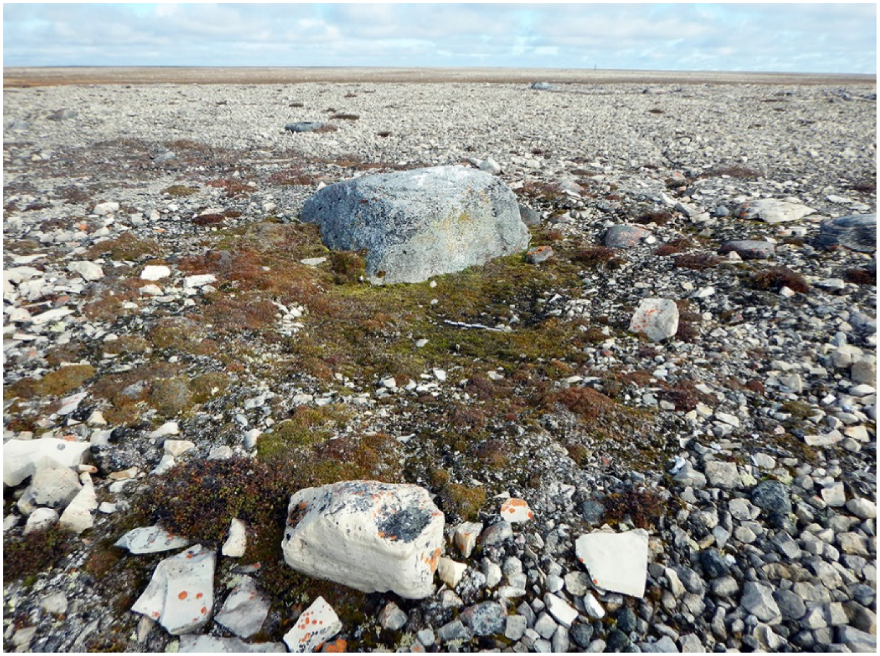
Fig. 10. Large boulder at NdLe-16. Test excavations were conducted along the edge of the boulder in the vegetated area in the center of the photograph.
Based on the recovery in 1973 of three metal buttons, a wide area around the boulder and the presumed grave was scanned with metal detectors but no targets were identified.
Five 50 × 50 cm test units were excavated along the edge of the shallow depression adjacent to the boulder. These yielded one human bone, two artifacts, and a small quantity of faunal remains. Although few, the items provided data suitable for addressing three interrelated research questions about NdLe-16: (i) the ancestry of the skeletal remains, (ii) the attribution of the site to the 1845 Franklin expedition, and (iii) the relationship, if any, between NdLe-16 and the Peglar site.
Ancestry
The single human bone found at NdLe-16 was a left first metatarsal. Based on its recovery context, it is presumed to be from the same skeleton exhumed at NdLe-16 in 1973. The metatarsal was intact and in good condition apart from the post-mortem loss of the distal end, which appeared to have been gnawed off by a small animal. DNA analyses yielded mitochondrial (U5a2a) and Y-chromosome (R1b) haplogroups indicative of a male of European ancestry.
Attribution to the Franklin expedition
The two artifacts recovered in 2019 are both buttons, one is two-piece and fabric-covered, and the other is made of bone (Fig. 11). The fabric-covered button (Fig. 11c) is dark brown and measures 13.6 mm in diameter. The shank portion is missing. The material covering the button face has a textured pattern of narrow bands approximately 1 mm wide. The bone button (Fig. 11d) was recovered from the same unit as the human metatarsal. It is complete and in good condition, measuring 16.7 mm in diameter with a slightly concave face and a 3.4 mm rounded rim. The back is slightly convex and has spin marks. It has four 1.8 mm vertical sew-through holes for fastening.

Fig. 11. Recto and verso views of buttons recovered in 1859 from the Peglar site and in 2019 from NdLe-16. a-b: two of four fabric-covered buttons from NMM AAA2117 (© National Maritime Museum, Greenwich, London); c: button NdLe-16:1 (© Government of Canada, Canadian Conservation Institute); d: button NdLe-16:2.
The absence of the 1973 collections from NdLe-16 precluded comparisons with the two buttons found at the site in 2019, but comparison with buttons recovered from the Peglar site by McClintock in 1859 yielded important results. The bone button has no counterpart in the McClintock collection at the National Maritime Museum, but similar examples have been found at Franklin expedition sites elsewhere on King William Island and the NdLe-16 specimen is not inconsistent with a Franklin expedition attribution. In contrast, the fabric-covered button proved to be highly diagnostic. Comparison of NdLe-16:1 with the fabric-covered specimens in the McClintock collection revealed it to be an exact match with four buttons attached to a piece of the waistcoat found with the Peglar skeleton (Fig. 11a, b). McClintock described the object (National Maritime Museum, AAA2117) as part of a “… double-breasted jacket of fine blue cloth – slashed sleeves, 5 buttons upon each, also covered buttons – jacket edged with silk braid” (McClintock, Reference McClintock1859a, Thursday 26 May). The textile is now almost completely disintegrated, but an illustration of the object showing three of the buttons appeared in the Illustrated London News in October 1859 (Fig. 12). The AAA2117 buttons range in diameter from 13.5 – 13.7 mm (A. Macken, personal communication, 2 February 2022).
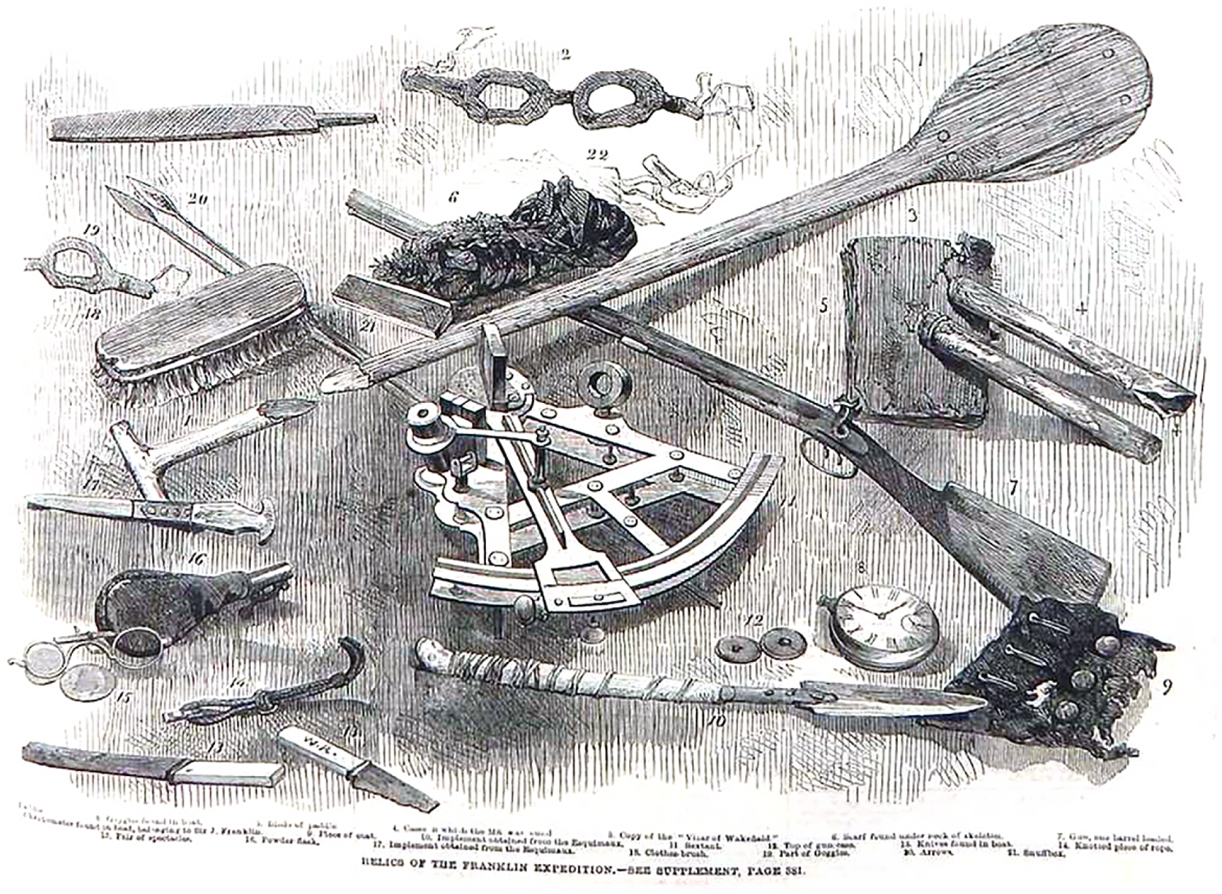
Fig. 12. Franklin relics recovered by the 1859 McClintock search expedition. NMM AAA2117, the waistcoat fragment with attached buttons found at the Peglar site, is shown in the lower right (#9 Piece of coat). (Illustrated London News, October 15, 1859).
Relationship of NdLe-16 to the Peglar site
The combined historical, genetic, and archeological evidence reveals that in 1973, the 1RCR rediscovered the site where McClintock had found and buried the Peglar skeleton on 26 May 1859. McClintock’s journal shows both the reason why the discovery site was mapped incorrectly and the information needed to determine its actual location. Crucially important site details recorded by Petersen in 1859 match those described by the 1RCR in 1973. Photographs taken in 1973 establish that the skeleton was in the supine position which both McClintock and the 1RCR misinterpreted as prone. DNA data from NdLe-16 confirm the remains discovered in 1973 were those of a male of European ancestry as was originally reported but for which no records have been found. Finally, the fabric-covered button recovered from NdLe-16 in 2019, identical to those from the waistcoat fragment McClintock found with the Peglar skeleton in 1859, indisputably unites the two discoveries.
An unresolved question concerns the presence of animal bones found with the skeleton at NdLe-16 in 1973 and from the test units excavated in 2019. A previous study (Stenton, Reference Stenton2018, p. 206) raised the possibility that given the absence of the artifacts and the analysis records, the presence of both human and animal bones in the grave at NdLe-16 could indicate that the deceased was an Inuk and not a European. Important details about the recovery context of the non-human bones found in 1973 are lacking, but the comparable patterns of weathering and staining on the bones as seen in the attempted reassembly of the skeleton confirm the admixture of human and non-human bones in the burial feature. Nevertheless, the possibility of Inuit ancestry for the human remains can now be rejected based on genetic evidence and a more plausible explanation for the mixed assemblage is the possible re-use of the grave by Inuit as a food cache or perhaps as a refuse area. Either form of re-use seems unusual, however, given Inuit knowledge of skeletal anatomy and the large number of human bones present in the grave in 1973. Descriptions of the 1859 interventions at the site contain no mention of animal bones or the presence of a pre-existing structure, suggesting that in constructing the grave McClintock had not repurposed an Inuit cache.
Conclusion
Investigation of NdLe-16 illustrates how inadvertent errors can shape elements of historical narratives about the 1845 Franklin expedition. It reveals that in 1973 the 1RCR unknowingly rediscovered the site where the Peglar skeleton had been found in 1859. A still unidentified member of the 1845 Franklin expedition died and was buried at NdLe-16, but not by his shipmates, but by McClintock just over a decade after the sailor’s death. McClintock’s placement of the Peglar site 9 miles southeast of Cape John Herschel was within a mile of the actual distance but his misidentification of Gladman Point resulted in the site being mapped about 13 km northwest of its actual location. Closer inspection of photographic evidence from NdLe-16 also reveals that contrary to the 1859 and the 1973 reports, the skeleton was not found in the prone position, a detail often highlighted as emblematic of the physical and mental exhaustion that foreshadowed the man’s death.
Further possible confusion about the location of the Peglar site is reflected in the place name that commemorates him. Peglar Point, approved as an official geographic name in 1961, is located 30 km southeast of Cape John Herschel, on the shore of King William Island about 1.5 km northwest of Eta Island (Fig. 6). The criteria on which this specific landform was selected for the name Peglar Point could not be determined, and while a commemorative name can be attached to any geographical place, it seems unusual for this name to have been officially assigned to a landform inconsistent with the published details of McClintock’s discovery including the, albeit incorrect, Arrowsmith map. Persons unfamiliar with the historical records might mistakenly conclude that Peglar Point is where the skeleton had been found.
Historical records of discoveries related to the 1845 Franklin expedition are important resources for archeologists, and the fact that they contain errors is unsurprising. Some are minor in nature and easily recognized, while others, like the McClintock example, are less obvious and more difficult to detect. By correcting the historical and archeological records about the Peglar site, the investigation of NdLe-16 underscores the importance of carefully evaluating all available forms of evidence. In some cases, the limited number and scope of archeological analyses of Franklin expedition sites has encouraged continued reliance on historical records for interpretive purposes, and it is hoped that the present study contributes to improving this situation.
Acknowledgements
This study was made possible through the generous assistance and cooperation of many individuals and organizations. I am grateful to the Government of Nunavut Department of Culture and Heritage, the Inuit Heritage Trust, the Hamlet of Gjoa Haven, and the Kitikmeot Inuit Association for their support of the field research and the analyses of human skeletal remains as part of the study of the 1845 Franklin expedition. The investigation of NdLe-16 would also not have been possible without the exceptional logistical support provided by the officers and crew of the Canadian Coast Guard ship Sir Wilfrid Laurier. Special thanks are also extended to Robert Park, Gavin Poole, and Amilia Xu for their assistance with the 2019 field investigations at NdLe-16.
The study of the Peglar site could not have been completed without the generosity of several individuals at the National Maritime Museum, Greenwich, and my sincere thanks are extended to Penny Allen, Scarlet Faro, Aisling Macken, Jeremy Michell, Glen Smith, Tina Warner, and Nicola Yates. At The Royal Canadian Regiment Museum, Georgiana Stanciu provided invaluable assistance with obtaining information about Exercise Northern Quest held in the museum’s Archives Collection. Special thanks are also extended to Major (retired) John O’Quinn and to Captain (retired) R. T. Walsh for sharing their personal knowledge of Exercise Northern Quest and important details about the discovery of the skeleton at NdLe-16. Sincere thanks are extended to Stacey Girling-Christie, Benoit Theriault, and Janet Young at the Canadian Museum of History for their advice and assistance in searching for information about the fate of the 1973 collections from NdLe-16. I also thank Jerome Cybulski for his helpful suggestions regarding the possible whereabouts of the NdLe-16 skeletal remains. Thanks are also extended to Kathleen Sullivan and Geneviève Desrochers at the Canadian Conservation Institute and to Edward Atkinson and Steve Perry at the Government of Nunavut. Philip Goldring’s assistance with searching for information about the naming of Peglar Point is also greatly appreciated. I also thank Logan Zachary for the historical images of the discovery of the Peglar skeleton and for his thoughts on various matters related to the 1857–59 McClintock search expedition.
Financial support
Field investigations were funded by the Government of Nunavut, Department of Culture and Heritage, Nunavut Archaeology Program. The DNA analysis was funded through a Trent University research grant to Anne Keenleyside.
Conflict of interest
None.


 Open access