

1. INTRODUCTION
The sounding lead and line, together with their shallow-water cousin, the sounding rod, have been used since antiquity, as evidenced by Herodotus (440BC) and Oleson (Reference Oleson2008). Also, their likely use in the North Sea during the so-called “Dark Ages” has been discussed in this Journal by Kemp and D'Olier (Reference Kemp and D'Olier2016). Taylor (Reference Taylor1959) recorded that Fra Mauro added a note to his magnificent 1458 Mappamundi which she translated as “Navigation is not by chart and magnetic compass, but by the sounding lead.” However, apart from one or two such early references, the present paper picks up the story in the sixteenth century, when a little more documentation becomes available. To keep the paper to a reasonable size, the author restricts his discussion, almost exclusively, to the use of the lead and line in British ships.
A useful starting point is the title page of Wagenhaer's (Reference Wagenhaer1584) masterpiece, Spieghel der Zeevaerdt (Figure 1). It is notable that the two major figures are both shown casting lead-lines, the importance of which might well be reflected by the sartorial splendour of the two gentlemen concerned. The Spieghel der Zeevaerdt was translated into English as The Mariner's Mirror and, to this day, its title page is reproduced on the cover of the Journal of the Society for Nautical Research.
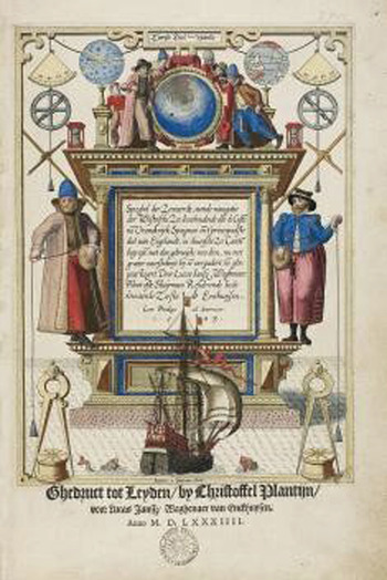
Figure 1. Title page, Spieghel der Zeevaerdt.
Few such illustrations exist although, going back to Norman times, Kemp and D'Olier (Reference Kemp and D'Olier2016) have previously noted the use of what appears to be a sounding line for testing the depth of water when approaching an anchorage, in scene 6 of the Bayeux Tapestry.
Another early reference that sets the scene for the present paper concerns the 15th Century first English “rutter”. Taylor (Reference Taylor1957) tells us that, in c. 1470 this document listed soundings and the nature of the sea-bed in the approaches to the English Channel. Some examples were included in Kemp and D'Olier (Reference Kemp and D'Olier2016) and are not repeated here. However, they comprised water depths of up to 80 fathoms, each with detailed sea-bed characteristics.
These last two references conveniently distinguish the two principal purposes for which the lead and line were used.
The Bayeux Tapestry shows a leadsman, on one of Harold Godwin's ships, monitoring the decreasing depth of water as the ship approached the shore, whilst a shipmate was standing ready to let the anchor go as soon as the appropriate depth was found.
The information in the English Rutter, on the other hand, was provided so that soundings with lead and line could be used to estimate a ship's position while well offshore. The depths quoted were too great for anchoring and the emphasis given to the nature of the sea-bed was very clearly related to areas off prominent points of land, such as Ushant and Lizard, which were not anchorages by any stretch of the imagination.
The considerable depths quoted show that fifteenth century sailors were prepared to go to a great deal of trouble to make use of this information. A ship would have had to be stationary through the water to measure depths much greater than 20 fathoms, and it would have been back-breakingly laborious to make frequent casts and, each time, retrieve by hand between 50 and 100 fathoms of wet rope with a heavy weight on the end.
Inventories of ships during the fifteenth century, for example Moore (Reference Moore1914), confirm that ships were supplied with sounding leads and lines, but the emphasis in this paper is to consider how this equipment might actually have been used at sea. Later inventories, and records of finding sounding leads in shipwrecks such as those recovered from the Mary Rose which sank in 1545, are of great general interest but are not touched upon again in this paper.
2. SIXTEENTH CENTURY EXPERIENCES
2.1. Rutters
In the sixteenth century, records describing the actual use of soundings were not plentiful, but they began to appear with what Taylor (Reference Taylor1959) described as, “The explosive entry of England into world affairs in the mid-years of the first Elizabeth.”
Waters (Reference Waters1958) tells us that the first printed English rutter was a translation by Richard Copeland from the French Le Routier de la Mer, ascribed to Pierre Garsie and published in Rouen from 1502. Copeland's first edition was in 1528. This contained much information concerning depth of water and the character of the sea bed, and was intended to provide navigational guidance for ships in the wine trade entering the English Channel.
Another section was added to this rutter in 1541, covering the “North Part”. This dealt with the Scottish coast and was based on Alexander Lindsay's “A Rutter for the Scottish Seas”. Lindsay's work contained detailed information on courses, distances and tides but, perhaps because of the different characteristics of the northern coastline, he confined his depth of water entries to a few anchorages.
Later editions based on Copeland's work contained enhanced information, and May (Reference May1970) has listed the soundings in the approaches to the English Channel from a 1567 edition as follows. Here and elsewhere in this paper, the transcription from archaic into modern English is due to the author, but the older form is retained in a few places where the meaning is clear.
If you are at 60 or 65 fathoms you shall find small sand and muddy grounds and you shall be off the coast of Ushant.
And if you are towards the bank of Scilly, you shall have 86 or 90 fathoms and you shall find in your lead stony ground and you shall make a great way towards the bank of Scilly.
When you are at 71 fathom you shall find small black sand and you shall be athwart of Lizard.
When you are at 60 or 65 fathoms you shall find white sand and white soft worms, and you shall be very close to Lizard.
Between the Peninsular of Cornwall and Ushant, in the middle of the Channel, you shall find 70 fathoms.
When you are athwart of Plymouth or Start Point you shall find stremy ground and dents in the tallow, and soundings of 41 or 42 fathoms.
On coming nigh to Portland you shall find 30 fathoms and stones like beans. And this sounding lasts until the Isle of Wight and, in the same depth, you shall find white stones and others that are greater, and then you shall be athwart the Isle of Wight.
Two or three leagues from the Isle of Wight you shall find 25 fathoms with dents or clefts in the tallow like small thread.
Two or three leagues from the Casquets you shall find 40 fathoms and big stones, rugged and black.
Between Beachy and the Isle of Wight you shall find, a league from the land, 38 fathoms and pebbles as big as beans.
Between Folkestone and Boulogne is a bank that is called Rippe Rappe which is in the middle of the route, as near Picardy as England, and close to it is 26 or 27 fathoms.
Beneath the Castle of Dover you shall find 10 fathoms.
In the strait of Calais you shall find 30 fathoms.
Between Calais and Thanet you shall find 25 fathoms.
The above listing is illustrated, graphically, in Figure 2.

Figure 2. Soundings in the English Channel.
At this point, it is appropriate to consider the accuracy of the soundings, and it is clear that many of the depths are exaggerated. The true fifty fathom line, shown in Figure 2, lies to the south-west of Land's End, yet greater depths than this are listed off the Lizard. Similarly, a depth of 30 fathoms off the Isle of Wight appears to be inside the 25 fathom line. These discrepancies might be due to the difficulty of ensuring that the lead-line was vertical when sounding in deep water. With a ship stopped in the water, a sounding line would only fall vertically to the sea bed if the whole column of water was stationary or moving with the tide at the same rate. In practice, the ship could be making leeway due to a wind, and a tidal stream would run more slowly at greater depths due to friction from the sea bed. Both these effects would cause the lead-line to depart from the vertical and thus to indicate an exaggerated depth of water.
There was also the difficulty of sensing when the lead had reached the sea-bed. In 1644 Mainwaring (Reference Mainwaring1644) gave the weight of a deep-sea lead as 14 lb (6·35 kg). However, the dry weight of a 1½ inch circumference rope (i.e. ½ inch diameter) is about 0·1 kg/metre, so 100 metres would weigh 10 kg. A back-yard experiment by the author indicated that, if the rope were wet, the weight would be more than doubled, say to 20 kg. Thus, when taking a 50 fathom (100 metre) sounding, the momentum of the lead-line running out would have been three times the momentum of the lead itself. Even in calm conditions, it must have been very difficult for a leadsman to sense when the lead reached the sea-bed and considerably more difficult in moderate sea conditions. Any delay in sensing when the lead reached the sea bed, as the line continued to run out under its own momentum, would have given rise to an exaggerated depth estimate.
A third factor is that some, at least, of the quoted depths were derived from French sources. As we are reminded by Cotter (Reference Cotter1971) the French fathom was shorter than the English fathom so that a depth of eight English fathoms would have been equal to nine French fathoms.
It is noteworthy that the above errors would always cause an increase in the measured depth and never a decrease. Their presence might well be a reason why rutters often gave prominence to the nature of the sea bed rather than the depth of water.
The information included in rutters accumulated over the years from soundings recorded by sailors during many routine trading voyages. It was extended by explorers and adventurers as they voyaged further afield where, in unfamiliar locations, they needed to test the water depth to find safe passages and anchorages. Much of the information was carried in the memories of mariners but updated printed records appeared from time to time.
William Bourne (Reference Bourne1574) published A Regiment for the Sea which included a listing of soundings in the English Channel, derived from Richard Copeland's earlier work. Wagenhaer's (Reference Wagenhaer1584) Spieghel de Zeevaerdt followed and also contained soundings for the English Channel which gave more emphasis to depths rather than the nature of the sea bed. The Spieghel der Zeevaerdt was translated into English by Anthony Ashley in 1588 as The Mariners’ Mirrour. Then, Edward Wright (Reference Wright1599) published Certain Errors on Navigation. This was a ground-breaking work in many ways but, for the purposes of this paper, we particularly note his chart of the North Atlantic from the Azores to the English Channel. This was on what is now known as the Mercator projection the mathematical basis of which had been first developed by Wright. The north-east section included comprehensive soundings in the western approaches to the Channel, and is illustrated in Figure 3.

Figure 3. Section of Edward Wright's Chart of Reference Wright1599.
The concentration and density of the soundings suggests that an organised effort had been undertaken to obtain them, which would have involved a huge expenditure of time and physical labour. Such an investment of resources underlines the importance accorded to soundings at that time. The soundings, themselves are typically about 30% greater than the actual depths, which might be explained, at least in part, by the author's previous comments on possible causes of error. However that might be, the 100 fathom line, as implied by those soundings lies only 110 nautical miles west of Land's End. This is well short of the true distance of 200 miles.
2.2. Sixteenth Century Explorers
Nicholas Bourne (Reference Bourne1652) collected a report describing the use of the lead and line for surveying a safe approach and anchorage during Sir Francis Drake's circumnavigation. Thus, on 27 December 1577, in the approach to Mogadore, it was recorded that:
Lying about a mile from the main, a boat was sent to sound the harbour and, finding it safe, and in way of the entrance on the north side about five or six fathom water (but on the southern side it is very dangerous) we brought in our whole fleet.
Similarly, Kenyon (Reference Kenyon1980) reproduced the Arctic Journal of Captain Edward Fenton in which, for the fourth of July 1578, we find that they entered a great sound, looking for a place to anchor:
And sailing 3 leagues into it, did sound it over and again and found 100, 60, 40 and 30 fathoms until we came to 15 along the north shore, being flat ground and shoal water but so rocky and hard ground that it was not possible to anchor in.
The next day, coming out of the entrance to the sound:
….. did set our sail and turned into the shore sounding, and found 34 fathom stremie Footnote 1 ground and there did anchor.
Of particular note are the depths of the soundings which Fenton recorded. Repeatedly retrieving up to 100 fathoms of line from icy water would have been no task for the faint-hearted. Such depths were of no use for identifying safe anchorages, but they were clearly felt worth recording for their navigational value.
Another late sixteenth century record, in somewhat warmer water, has been left by Sir Richard Hawkins who, in July 1593 was approaching the coast of Africa in about 5° North. As recorded in more detail by Kemp and D'Olier (Reference Kemp and D'Olier2016), he unexpectedly came across shoal water and sent boats ahead of the ship to sound and thus to find a safe anchorage.
These examples show the care with which the early explorers took soundings in order to keep their ships from stranding and to discover safe anchorages. This information would then have been used to provide greater detail on rutters and to extend their application.
Soundings were also recorded in depths of water where there was no intention of anchoring (as in Fenton's case) and these provided positioning information for later navigators.
2.3. The use of soundings for navigation
Fenton not only recorded soundings during his explorations, but a journal of his also provides an example of the value of using known soundings for navigation. This document is included in a book, edited by Taylor (Reference Taylor1959) entitled (with some understatement) The Troublesome Voyage of Captain Fenton. His was an abortive venture, during 1582/83, originally intended to instigate spice trading with the Moluccas. We pick up the story as Fenton, having abandoned an attempt to reach Newfoundland (don't ask), approached the English Channel from the Atlantic.
Fenton gave a day-to-day account of his progress, which included the courses and distances sailed and his estimate of each day's run. He also recorded the weather and other significant observations. When the sky was clear, he included an observation of “altitude”, which would have been that of Polaris. In 1583, Polaris was about 3° from the true pole, but we know that Fenton had, on board, tables, translated from the Portuguese, which allowed a correction to be made to an observed altitude to find the altitude of the true pole. The altitude of the true pole is, of course, equal to the observer's latitude.
Ninety-six days after last sighting land, Fenton recorded the following:
Friday the 7 June. At midday went till 7 the next day, E for 14 leagues and E by S for 14 leagues. Sounded at 5 o'clock in the afternoon at Thomas Hood's request and had no ground, notwithstanding that he supposed himself to be within 60 leagues of the Lizard.
Thomas Hood had sailed with Sir Francis Drake and was one of two pilots on board Fenton's ship. In this case, he clearly felt that they had made sufficient easterly progress to be within 180 miles of the Lizard and within soundings. That is, in water depths of less than 100 fathoms. (Note that Thomas Hood's 60 leagues (180 miles) was a better estimate of how far the 100 fathom line was west of Lizard than was the 110 miles indicated by the chart of Figure 2). The previous day, Fenton had recorded an altitude of 50°19′. The Lizard is actually in 49°58′N, but latitudes were not accurately known or observed in Fenton's time and were still a matter of uncertainty over a hundred years later. For example, in 1697, a table by Colson gives the latitude of the Lizard as 50°10′ N. and that of the Isles of Scilly as 50°12′ N. (Bishop Rock is actually in 49°52′ N.). And there was a spread of up to 48′ in the latitudes observed by officers in the ill-fated squadron of Sir Clowdisley Shovel in 1707 (see May, Reference May1960). In the event, it was not until 10 June that Fenton's ship came into soundings as was reported by the following entries in his journal.
Monday the 10 th day. Very early in the morning we sounded and had 108 fathoms, fair white small sand, being then upon the entry of the Bank, as Simon Farnando Footnote 2 told me and at midday went till 7 the next day E. 12 leagues and E. by S. 13 leagues at 8 o'clock at night and had the like as above.
Tuesday, the 11 th day. At midday we went till 7 the next day E. & SE 24 leagues. Sounded at 6 o'clock at night and had 80 fathoms like the first with some red specks therein.
Wednesday, the 12 th day, sounded in the morning and had similar shoaling with some shells. At midday, very stormy We triced in our main-sail and saw a sail to the west of us until 7 at night, S. 3½ leagues. Sounded and had 85 fathoms small brown sands with little shell and like slivers of flax, and so till 7 in the morning SE. 5 leagues, and then descried certain hulks towards whom we steered until 8 o'clock but could not overtake, SSW, 5 leagues. Then we sounded and had 85 fathoms, brown sand with St James shells being upon the Bank and Scilly as we supposed N. or N. by E of us. Cast about and went for Ireland, NW. by N. 5 leagues.
Altitude 48 ° 48′. Wind at NE. and ENE. and E.
Thursday the 13 th day. At Midday went till 12 the next day NNW. 21 leagues.
Altitude 49 ° 52′. Wind at E. and ESE. and SE.
Friday, the 14 th day. At midday went until 12 the next day N. 18 leagues and N. by W. 9 leagues. Sounded at 6 o'clock at night and had 65 fathom, ooze.
Altitude 51 ° 31′. Wind at SE.
Saturday the 15 th day. At 8 o'clock in the morning discovered land (God be praised) towards Youghal in Ireland, having been 103 days without sight of any land, and so went NNW. And NW. to Kinsale, where we came to anchor (God be praised) about 3 0’clock in the afternoon, going N and N. by E. into the haven ……..
The author has worked back from Fenton's arrival at Kinsale to his position on Monday 10 June, using his estimates of daily progress, taking 3 miles to the league and bearing in mind that a nautical mile (1 minute of latitude) was, at the time, thought by British seamen to equal 5000 feet (Waters, Reference Waters1958). Also applying a variation of 10°E (its value in 1583) to Fenton's courses. The resultant track is shown in Figure 4, and there are a number of points of interest.
-
(i) For a ship approaching the English Channel from the west, the 100 fathom line provided a reliable indication of longitude. This at a time when the only alternative was by dead-reckoning which was likely to be hugely in error after, perhaps, a three months crossing of the Atlantic. As noted in Section 6 below, this depth contour was still being used as late as 1948. In Fenton's time there would, no doubt, have been differing views amongst pilots as to how far the 100 fathom line lay to the westward, but Hood clearly knew that it was at least 60 leagues (180 miles) from the Lizard because he expected to be within soundings at that distance. This corresponds well with the actual figure of 200 nautical miles.
-
(ii) On 10 June, Simon Ferdinando told Fenton that the sounding of 108 fathoms marked the ship's entry to the “Bank”. That is to the continental shelf which extended to the 100 fathom line and then dropped, precipitously, to thousands of fathoms. The previous latitude observation had been during the night of 6/7 June 1583 but, at 50°19′ Ferdinando would have been confident that the ship was well to the south of the Irish coast.
-
(iii) For the next two days, Fenton headed somewhat south of east, evidently making to the English Channel. On the morning of Thursday 13 June, he tried, unsuccessfully, to make contact with some local vessels. Based on a sounding of 85 fathoms, brown sand and shells, and a latitude, observed during the previous night of 48°48′, he supposed that the Isles of Scilly lay in a N or N by E direction, which showed an impressive awareness of the ship's position after his long Atlantic crossing (Figure 3 suggests they were actually ENE). The depth of water matched that shown in Figure 2, south-east of Scilly although the bottom sample of brown sand differs from the stony ground suggested by the rutter. No doubt, Hood and Ferdinando would have had their own views as to what the brown sand signified.
Whatever the case, and perhaps influenced by the generally easterly winds, Fenton then decided to make for Ireland. Accordingly, he headed a little to the west of north and reached Kinsale on Saturday 15 June.
-
(iv) Fenton does not give a time for the “altitudes” that were observed when Polaris was visible, but they must have been taken in periods of twilight or darkness during the short June nights. Within this uncertainty, they all appear to be remarkably good (perhaps within 10 minutes of arc) as compared with the reconstructed track of the Galleon Leicester.
Whatever his limitations as a leader of men and a decision maker, Fenton was well served by his two pilots who brought his ship back to England with impressive confidence considering the limitations of the available equipment and knowledge.
3. 17th CENTURY PROGRESS
The format of the lead and line used at that time is confirmed by an entry in Sir Henry Mainwaring's (Reference Mainwaring1644) Seaman's Dictionary. He tells us that the deep-sea lead-line was a “small line”. That is, it was thin as compared with the shorter, hand lead-line, which reduces the weight and makes sounding practicable, although still hard work, in deep water.
He leaves us in no doubt as to the value of the information provided by deep water soundings: “… and so, according to the depth and ground in many known places, as in coming into our Channel and many other places, when we can see no land yet we know where we are.
In the seventeenth century, there were many voyages of routine trading in familiar waters where soundings and the nature of the sea bed provided a principal method of navigation. For the English Channel and its approaches, these are well documented in publications such as A Regiment for the Sea by William Bourne (Reference Bourne1574) which continued through several editions to 1587 and then, with revisions by Thomas Hood to 1631. New observations were included in the Great Britain Coasting Pilot produced by Captain Greenville Collins (Reference Collins1693) following the first systematic survey of British waters which he had completed in 1681.
There were also increasing numbers of voyages by adventurers and merchants probing further afield into unknown waters, where taking soundings would be a matter of prudent navigation and recording them would provide guidance for subsequent voyages.
For example, May (Reference May1970) tells us that Henry Hudson, on his third voyage, sounded regularly when approaching the Newfoundland Banks in July 1609. In the deep Atlantic water, he usually sounded once every day, often at 2000 hours to avoid falling in with the land during the night. Once he had found bottom, he sounded more frequently. Thus, at that time on 6 July, he found no ground at 100 fathoms but, at the same time on the following day he found ninety-five fathoms with a sample of white sand. This kind of routine was of immediate value for the safety of his ship and, by recording the soundings, he provided information that could be included in rutters or on charts.
An example from even more distant waters is the case of Captain John Daniel whose ship, the New London, came across shoal water and islands off the coast of what is now Western Australia in 1681 (Lee, Reference Lee1925). Daniel took soundings and sketched a chart of his findings, which comprised the northernmost of the Abrolhos Islands, an archipelago surrounded by shoal water.
Although Daniel appears not to have known it, the islands had been discovered and described by the Dutchman, Frederick de Houtman, commanding the ships Dordrecht and Amsterdam in 1619. Houtman gave the position of the Islands as 28°46′S. and Daniel, who only saw the northerly islands of the group, 28°36′S.
Few other points along the Western Australian coast had been visited at that time and it is of interest that The Abrolhos Islands appear to have been the target landfall for William Dampier as he approached that coast in 1699 in his ship, the Roebuck. Dampier had on board a chart which he said was by Abel Tasman, who had mapped the north-western coasts of Australia in 1644. Whether from this chart, or elsewhere, Dampier believed the Abrolhos Islands to be in 27°28′S. Thus, when debris in the water indicated that he was approaching land in latitude 28°36′S at night-time, he found 45 fathoms of water over coarse sand and thought he was off the southern end of the shoal water. He therefore altered course to the south, which was logical, but wrong. Unknown to Dampier, he was in the latitude Daniel had found for the northernmost island in the group, and to the north of the latitude Houtman had recorded. The error became apparent as the soundings decreased and he found a coral bottom, so he made a 180 degree turn and headed north until the soundings increased.
Clearly, it was not only in the approaches to the English Channel that reliable information on soundings was of great value to the early navigators.
4. CONTINUED USE OF LEAD AND LINE
By Dampier's time, more accurate instruments, such as the Davis Back-staff, had become available, and reliable predictions of the Sun's declination were published, so that observations of a ship's latitude were facilitated. However, a ship's longitude could not be found by astronomical means and estimates made by dead reckoning led to increasing errors as a voyage progressed.
As has been already noted, the 100 fathom line in the western approaches to the English Channel provided an estimate of longitude which became of increasing value as its position became charted more reliably. Further to the east, the 50 fathom line, running north-south from the Scilly Islands to Ushant, provided another check on a ship's longitude. (The only deeper soundings to the east were those in the narrow canyons of the Hurd Deep.)
Moving into the 18th Century, the invention of the reflecting quadrant by Hadley in 1731 allowed greater precision in the measurement of latitude. John Hamilton Moore (Reference Moore1772) published his “Practical Navigator and New Daily Assistant” which, among many other items, included advice for entering the English Channel. Moore recommended that a ship should keep to latitude 49° N, and he then listed the water depths and bottom samples that should be expected as the ship progressed. See Cotter (Reference Cotter1971) for a note as to how Moore's advice changed in successive editions of the “Practical Navigator”, up to the 19th edition in 1814Footnote 3 . There was also a table, contained in the 1796 and subsequent editions, listing the soundings and seabed quality to be found at distances up to 150 miles from Ushant along the parallels of 48°20′N and 48°30′N.
By the end of the 18th Century, chronometers and accurate lunar tables made it possible to find longitude by astronomical observation, but chronometers were expensive and many mariners lacked the capability of performing the calculations required to reduce lunar observations. The lead-line therefore continued as an important navigational instrument until well into the 19th Century, by which time mechanical systems, developed by Kelvin and others, allowed deep water soundings to be measured with greater convenience and while a ship was under way.
Following Moore's “Practical Navigator”, a number of other navigation manuals were published in the UK, including popular works by Norie, Raper and Lecky, but these no longer contained a listing of soundings and the associated character of the sea bed. This was surely because of the increasing availability of reliable charts which provided such information in a more graphic and useful format. The first Admiralty chart was issued in 1800 and Admiralty charts became available for sale to the general public in 1821.
Pre-dating the Admiralty charts were the, so called, “Blueback” charts, published privately by a number of mainly London-based companies who, in the early 20th Century, became consolidated into Imray, Laurie, Norie and Wilson, Ltd. The “Bluebacks” remained popular among merchant seamen and fishermen up to World War II. (See Fisher, Reference Fisher2001a; Reference Fisher2001b). Under the Imray imprint they continue to be much used by yachtsmen and fishermen.
On the early Admiralty charts and Bluebacks, the 100 fathom line appeared, as shown in Figure 4. This was near its true position as shown on modern charts and well to the west of its position on Edward Wright's chart (Figure 3).

Figure 4. Fenton's track in the Western approaches to England and Ireland.
Charles Cotter (Reference Cotter1971) (a sometime colleague of the author) referring to the end of the 19th Century, suggested that:
Long before the advent of the echo sounder, by the use of which it is not possible to ascertain the nature of the bottom, navigation by sounding lead {\ldots} had become an obsolescent art.
Few people would argue with that as a general statement, but the use of soundings for particular applications, although less and less frequently measured with lead and line, continued into the 20th Century.
5. TWENTIETH CENTURY APPLICATIONS
By the beginning of the 20th Century, the use of astro navigation for position fixing was a matter of routine. However, in overcast conditions which, especially in temperate latitudes, might persist for many days, soundings continued to provide a valuable navigation aid as discussed by Kemp et al. (Reference Kemp, Cockcroft, Gylden, Iijima, Koburger, Lyon, Page and Thirslund2008). This included the long established practice of locating the 100 fathom line when approaching the English Channel from the west or the south-west. In the early years of the 20th century use was made of a Kelvin sounding machine, or similar, as reported by Kemp from personal experience in 1948. However, from the 1930s ships were increasingly fitted with echo sounders which provided a more convenient method of locating a depth contour and, since such contours were generally parallel to a coastline, they frequently made a good cut with a shore-based radio beacon. The previously noted 100 fathom line was a special case of this technique so that, when approaching the south-west of Ireland from the Atlantic, the contour made a good cross with a bearing from the radio beacon at Mizen Head or Bishop Rock or, when approaching the English Channel from Biscay, a good cross could be obtained with a bearing from the radio beacon at Ushant. This was a useful method of fixing position in fog before the advent of radar and electronic position fixing systems made it redundant.
Nevertheless, there remained some notable uses of the lead and line, including the remarkable escape of the Pacific Steam Navigation Company's Ortega when pursued by the German cruiser Dresden, off the south-west coast of Chile in September 1914 (Lyon, Reference Lyon2016). Rather than surrender his ship to the faster Dresden, Captain Kinneir made his best possible speed towards and into the Estracho de Nelson (Nelson Strait). This was un-surveyed and the “American Pilot” of 1916 reported that it led “into a shallow, rock-strewn basin.” Captain Lüdecke of the Dresden, wisely, declined the challenge but Captain Kinneir, faced with the certain loss of his ship if he tarried, proceeded into the strait. He put down two boats which went ahead to sound and to find a viable passage through the reefs and the rock pinnacles, just as Drake and Hawkins had done in the 16th Century.
It is a daunting prospect when a navigator has to make a tortuous passage through a charted area marked with many shoals, rocks and other dangers to navigation. Even worse, is to be confronted, as Captain Kinneir was, by a known dangerous area shown on the chart as an expanse of white paper with not so much as a sounding marked. Despite the many dangers, including strong currents and tidal rips, he took his ship safely through the Estracho de Nelson (Nelson Strait) and then back to open water through the longer, and equally treacherous, Canal Smyth (Smyth's Channel). See Figure 5.

Figure 5. Escape route of the Ortega (marked in red)
Captain Kinneir's use of the lead and line was an exceptional event, but the lead and line were used routinely, into the 20th Century, by fishermen. As related by Cooper (Reference Cooper2010), in 1937 his father took his trawler from Lowestoft to the Dogger Bank on a three-day voyage, finding his way and monitoring his progress at the fishing ground exclusively by use of the lead and line. His Blueback charts remained rolled up and were never consulted. Some discussion of how he might have used sea-bed information is contained in Kemp and D'Olier (Reference Kemp and D'Olier2016). Later in the 20th Century, electronic position fixing systems and sophisticated acoustic “fish-finders” were developed and the lead and line became redundant for fishermen.
6. CONCLUSIONS
During the 16th Century and until the finding of longitude became a matter of routine, the lead and line was a vital navigation aid, although the author suggests that, in the literature, it has not been accorded the importance it merits. Its use for making a safe approach to an anchorage was invaluable until the general introduction of the echo-sounder in the 1930s. More controversial was the use of lead and line for position fixing in offshore waters. However, the recording of water depths greater than 50 fathoms, together with sea-bed information in sailing directions and later on charts, could only have been for that purpose.
May (Reference May1973) writing about the history of the lead and line, observed, “That we hear little about it is not surprising, for it is so simple that no-one would think it necessary to describe it.” Just so.


