


Introduction
The recent 2007 Intergovernmental Panel on Climate Change (IPCC) assessment noted that, like glaciers worldwide, tropical glaciers have been in a state of retreat from their mid-19th-century maximum. Since the 1970s, coinciding with the beginning of the Landsat satellite era, tropical glaciers have been retreating quickly. Moreover, the smallest tropical glaciers appear to be the most affected (Reference Lemke and SolomonLemke and others, 2007). While glaciers in the Andes and in East Africa have received the most recent attention, work on the last remaining glaciers in Papua, the Indonesian western half of the island of New Guinea, has been more limited. Advances in satellite technology and methods for detecting and analyzing glacier areas are enabling us to better document the retreat and demise of these small ice masses. A better understanding of the temporal changes in these small, and quickly disappearing, ice masses may aid in gaining better knowledge of the exact climate–glacier interactions in this region. Important to this endeavor is to document the pattern of glacier recession whenever possible so that an adequate archive exists such as is being created by the Global Land Ice Measurements from Space (GLIMS) project.
The 2500 km long Pegunungan Maoke (Central Range) forms an east–west spine down the center of the island of New Guinea. During the 20th century, four areas of this range are known to have supported glaciers. Allison and Peterson (1989) reported that the Indonesian portion of the island, Papua (officially named Irian Jaya until 2002), still supported glaciers into the early 1980s. Two of these areas, the Puncak Jaya massif (Carstenz) and Ngga Pilimsit (Idenburg-top), lie within 20 km of each other, while a third, Puncak Mandala (Julianatop), lies several hundred kilometers to the east (Fig. 1). A fourth area, Puncak Trikora (Wilhelminatop), is known to have supported a small ice cap which disappeared during the period 1939–62 (Reference MercerMercer, 1967). Recently, Reference Klein and KincaidKlein and Kincaid (2006) reported the disappearance of the glacier on Ngga Pilimsit by 2003 and speculated that the glaciers on Puncak Jaya will disappear within the next 50 years.
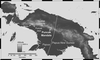
Fig. 1. Map of New Guinea showing the location of areas known to contain glaciers during the 20th century.
However, the current state of the small ice cap on Puncak Mandala has been unknown until now. Allison and Peterson (1989) were able to identify its existence on Landsat multspectral scanner (MSS) images acquired on 19 August 1981, 21 March 1983 and 3 January 1984. We utilize remote sensing to ascertain whether an ice cap remains on Puncak Mandala. Specifically, freely available Landsat MSS, Thematic Mapper (TM) and Enhanced TM Plus (ETM+), as well as Advanced Spaceborne Thermal Emission and Reflection Radiometer (ASTER), images archived within the United States for the period 1973 to May 2007 are examined to determine if an ice cap remains on the peak.
Puncak Mandala
Puncak Mandala (4°42′30″ S, 140°17′21″ E) is the highest peak (4640 m a.s.l.) in the Star Mountains of central New Guinea (Fig. 1). It is composed of massive limestone units that dip to the north, causing the peak to be asymmetric, with steep southern cliffs and much gentler slopes to the north. Because of the dip, the extent of both recent and Pleistocene glaciers in the range has been more extensive on the gentler northern slopes (Löffler, 1982).
Compared to the glaciers on Puncak Jaya, the small ice cap on Puncak Mandala has received scant study. However, Puncak Mandala has been known to have glacier cover since 1909, when the earliest observation of snow cover on the peak was recorded and a sketch of the ice cover was made (Anon., 1913; Reference Brongersma and VenemaBrongersma and Venema, 1963). Oblique aerial photographs taken in 1945 by the United States Air Force show a small summit glacier lying to the north of the peak on the gentler northern slopes (Reference VerstappenVerstappen, 1960). In 1959, a Dutch group climbed the peak and estimated the glacier to be approximately 100m thick (Reference Brongersma and VenemaBrongersma and Venema, 1963), while photographs taken in 1959 show the ice cap to be semicircular in shape. None of these observations enabled the ice loss to be calculated, although Reference VerstappenVerstappen (1960) did note that the glacier appeared to have been in rapid retreat from 1945 to 1959. Allison and Peterson (1989) were able to identify the ice cap on early 1980s MSS images, but these were of insufficient quality to map its extent.
Methods
Multiple archives of Landsat and ASTER images held within the United States, including those at the United States Geological Survey’s (USGS) EROS Data Center, the University of Maryland’s Global Land Cover Facility archive and Michigan State University’s Tropical Rain Forest Information Center, were searched for suitable images. The scenes selected for analysis are listed in Table 1. Unfortunately, digital versions of the MSS images originally analyzed by Allison and Peterson (1989) are not currently held in the USGS EROS Data Center archive. This precluded a direct comparison of the images used to identify the ice caps in the early 1980s with more recent images.
Table 1. Satellite images of Puncak Mandala selected for analysis

All selected images were georectified to make it possible to easily locate Puncak Mandala despite extensive cloud cover obscuring identifiable topographic features. To georectify the images, a TM image acquired on 19 March 2000 and obtained from the University of Maryland’s Global Land Cover Facility archive was selected as the base image. All other Landsat images were rectified to this base using a first-order polynomial warp. A small number of ground-control points (GCPs) were selected through visual analysis on each image. The root-mean-square (rms) errors for the control points were one to two pixels (30–60 m), which is adequate for qualitatively assessing the presence or absence of an ice cap. All ASTER images were geolocated to within a few hundred meters using the location information provided with the images, which was sufficient to identify Puncak Mandala.
Following georectification, images with cloud-free, or at least partially cloud-free, views of the peak were selected for further analysis. Unfortunately, due to persistent cloud cover, only three Landsat images (Table 1) could be located that provided sufficiently cloud-free views of the peak that enabled unambiguous identification of the presence of snow/ice on Puncak Mandala.
The area of ice/snow remaining on Puncak Mandala was determined in two manners, visual analysis and the normalized difference snow index (NDSI). False-color composites were created from Landsat bands 5 (1.55–1.75 μm), 4 (0.76–0.90 μm) and 2 (0.52–0.60 μm) and ASTER bands 4 (1.60–1.70 μm), 3 (0.76–0.86 μm) and 2 (0.63–0.69 μm) as red, green and blue, respectively. The glaciers were clearly distinguishable from the light-colored limestone bedrock. The NDSI is the normalized difference ratio between a visible band (Landsat band 2) and a shortwave infrared band (Landsat band 5) and has a long history of use in the detection of snow (Reference Hall, Riggs and SalomonsonHall and others, 1995). It is computed as follows:
Several NDSI thresholds ranging from 0.3 to 0.5 were used to identify snow- and ice-covered pixels and serve as a check on the visual estimates of snow and glacier area.
Results
Despite being partially obscured by cloud, a small area of snow/ice (approximately 10 000–12 000 m2) could be visually identified on the peak in an image acquired on 6 April 1989. Further visual analysis of a cloud-free image acquired 4 months later on 4 August 1989 indicated a snow/ice extent of approximately 15 000 m2 on the summit (Fig. 2). While it is impossible to differentiate between snow and glacier ice in these two images, the consistent presence of snow/ice over 4 months in the same geographic location suggests that a glacier could be present and that the Mandala ice cap could not have exceeded 15 000 m2. A cloud-free image of the Puncak Mandala summit acquired on 12 March 2003 shows no snow or ice present (Fig. 3).

Fig. 2. Landsat band 2 image of the possible ice cap remaining on Puncak Mandala on 4 August 1989. The remaining snow/ice is enclosed by the white circle.

Fig. 3. Landsat ETM+ band 2 image acquired on 12 March 2003 showing no ice and snow present on Puncak Mandala.
Two additional ASTER images acquired on 21 July 2001 and 31 May 2003 support this conclusion. Although the peak itself was cloud-covered in these, scattered transient snow was visible on the south-facing slopes below the peak. No such transient snow was present in the two Landsat images with snow/ice visible on the peak. This strongly suggests that the snow and ice present on the summit in the Landsat images is likely the remnants of the ice cap.
Discussion and Conclusions
Given the analyzed images, it is reasonable to conclude the ice mass visible on two dates in 1989 was probably the remains of the Puncak Mandala ice cap. The entire ice cap must have disappeared entirely before March 2003, probably several years earlier given its small size in 1989. Thus the only remaining ice masses in Papua (formerly Irian Jaya) are on Puncak Jaya. While it is impossible to quantify the retreat of Puncak Mandala over the 20th and early 21st centuries, as with other glaciers in Papua and across the tropics the ice mass on Puncak Mandala was in a state of retreat over this time period and finally disappeared in the 1990s or early 2000s.
Acknowledgements
This work was funded by NASA grant 02000-015. We thank S. Hastenrath for inquiring into the status of this ice cap which served as the impetus for this study.
7 November 2007


