


Introduction
An ice core, drilled in 1966, for glaciological and climatological studies through the Greenland ice sheet at Camp Century (Fig. 1) penetrated 3.5 m of sub-ice material. The sub-ice part of the core is till-like material (Reference Hansen and LangwayHansen and Langway, 1966) containing numerous cobbles and fragments of crystalline rock. Debris apparently derived from the sub-ice material is abundant in the 16 m of ice immediately above the ice-sub-ice interface (Reference Herron, Hoar and LangwayHerron and Langway, 1979; see Fig. 2). It is probable that the large cobbles are representative of the local bedrock, although the thickness of till underlying the ice sheet at this site is not known. The dynamics of the ice sheet indicate that, if the cobbles are not locally derived, they must have been transported from further inland. The sub-ice material of the Camp Century core thus provides a rare though incomplete look at the geology of the bedrock beneath the ice sheet.

Fig. 1. Location map showing the relative positions of Camp Century and the coastal exposures of the Rinkian mobile belt (shaded area; after Reference Dawes, Escher and WattDawes, 1976). Principal exposures are in Inglefield Land, to the north of Thule, and on Melville Bugt, south of Thule.
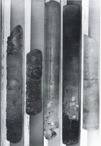
Fig. 2. All of the approximately 3.5 m of sub-ice core and about 25 cm of the “dirty” ice recovered at Camp Century. The sections are in order from right to left: section 1 at the far right is the uppermost section; section 5 at the far left is the bottom section of the core. The top section (1) shows the contact between the main glacier mass and the sub-ice material. Beginning at the contact in section 1, the sub-ice material is sandy, grading to a finer sand (section 2), and still lower, a wedge of very coarse pebbles in a silty matrix. Beneath the wedge and continuing in section 3 is a thick layer of higher ice-content silt-clay that extends almost to the bottom of the section. At the bottom of section 3 is an ice lens nearly 10 cm thick. Sections 4 and 5 show the till-like material containing a heterogeneous assortment of non-stratified cobbles and pebbles in a finer sand-silt-clay matrix. (Photograph by D. Atwood, CRREL.)
The sub-ice material has received little geological attention as it represents samples of unknown lithologies and structures from beneath the ice. However, similar studies on grab samples from lunar rocks and meteorites have indicated that such investigations are not totally futile. Therefore, a petrographic and geochemical study of the crystalline rocks from the sub-ice material was undertaken in an attempt to characterize the bedrock geology and to provide the basis for possible correlations with the exposed crystalline basement on the perimeter of the ice sheet.
Sub-ice material
The sub-ice material is a mixture of cobbles, fragments, and dirty ice, and consists of approximately 50-60% crystalline ice. Seventeen rock samples were removed from the ice for this study; these included igneous, metamorphic, and sedimentary specimens. The samples weighed between 4 and 1132 g, but the weights are unrepresentative as most specimens were cut by the drill bit during coring. Numerous smaller fragments were also observed in the core. The larger samples were relatively fresh with only a small weathering rind, typically rimming the smooth uncut surface. Some of the smaller fragments showed extensive weathering effects. These included a shale fragment that could not be removed intact due to its deteriorated condition.
The densities of the samples were also determined and are listed in Table 1. A slight correlation seems to exist between the density and the vertical stratigraphic position of the specimens in the core, with the least dense samples near the top. The cobbles appeared in groupings with depth; no large fragments or cobbles were found in the upper 1.2 m, and none was found between 1.3 and about 2.5 m. The majority of the large fragments were found between 3.0 m and the bottom of the core. No explanation for this distribution is offered.
Petrography
Based on thin-section petrography, the majority of the sampled rock types could tentatively be ascribed to a single metamorphic complex consisting of gneisses, granites, and metabasalts. There are four granodioritic gneisses, six tonalitic gneisses, three granites, a basic amphibolite, and a basic granulite (Table 1). If the rocks are considered as part of a metamorphic complex, the mineral assemblages present are not sufficient to delineate accurately the metamorphic regime but, in general, the assemblages fall into the broad category of upper amphibolite facies. Temperatures and pressures are estimated to between 550°C and 650°C, and about 4 kbar.
In addition to the crystalline rocks, there are also a relatively pure sandstone and a silty sandstone, which show minor metamorphic features.
Geochemistry
Ten crystalline rock samples were selected for analysis on the basis of petrography. Chemical analyses were performed using U.S. Geological Survey “rapid” analysis techniques (Reference ShapiroShapiro, 1975), except for rare-earth element and isotopic analyses, which were determined by isotope-dilution mass spectrometry. The results of the chemical analyses are given in Table II. The major-element compositions of the samples are fairly typical of granitoids. There is no regularity in the variation of total iron, MgO, CaO, Na2O, and K2O with silica. No regular pattern of variation of either major-element chemistry or modal abundances is evident even within the granitic gneiss.
Table I. Modes, densities, core positions, and cobble sizes of samples from the sub-ice material from the Camp Century ice core

The abundances and distribution of the rare-earth elements are also typical of granitoids; the light rare earths are highly enriched relative to the heavy rare earths with considerable variation between samples. As in the major-element data, the rare-earth data display no regular pattern of variation with lithology. As the rare-earth elements are believed to be relatively immobile during amphibolite-facies metamorphism, the data should reflect differences in the parental rock compositions of the meta- morphic samples.
Table II. The chemical composition of crystalline rock samples from the sub-ice material of the Camp Century ice core. Oxide values in weight per cent; rare-earth abundances in p.p.m.

Two of the samples (1062-1A and 1063-1A) have been analyzed for whole-rock Rb-Sr systematics. These two samples are nearly identical in rare-earth element abundances and therefore may be related. Together they indicate an age of about 1100 Ma. Individually, they give model ages using a 0.701 initial of 3660 and 2760 Ma. Considering the initial of 0.712 associated with the 1100 Ma age, it is tentatively concluded that these are approximately 3000 Ma old rocks that were reset to 1100 Ma during the Carolinidian orogeny. A Hudsonian age (about 1800 Ma) might be more reasonable, based on exposed rocks of similar lithologies on the north-western coast of Greenland but, even given very large errors, the samples do not approach a line of this age. Therefore, these samples either cannot be used together to define an isochron or they are younger than Hudsonian. Additional work is needed to resolve the ages of the samples from the sub-ice material.
Discussion
Reference Dawes, Escher and WattDawes (1976) has described rocks from the crystalline basement complex in the Melville Bugt- Inglefield Land area that are essentially identical to those obtained from the Camp Century sub-ice material. This complex is part of the Rinkian mobile belt (Reference Dawes, Escher and WattDawes, 1976) that is exposed for over 700 km along the northern half of the west coast of Greenland (Fig. 1). If the Camp Century samples are associated with the Rinkian mobile belt, then the mobile belt must extend at least 200 km inland to the east. However, the Rinkian mobile belt is Hudsonian in age (1650-2000 Ma), while the Camp Century samples are tentatively dated at 1100 Ma and are associated with the Carolinidian orogeny. The effects of the Carolinidian orogeny are strong on the east coast of Greenland but weak on the west coast. It appears that the Camp Century rocks cannot be simply correlated with the rocks on the west coast of north-west Greenland and the geologic make-up of inland northern Greenland remains an enigma that will not be solved until more samples, preferably of bedrock from beneath the ice sheet, are available.


