

No CrossRef data available.
Article contents
V.—On the Three Glaciations in Switzerland
Published online by Cambridge University Press: 01 May 2009
Extract
Until very recently it was thoroughly recognised that in post- Tertiary, viz., Pleistocene or Diluvial times, there occurred in Switzerland, as elsewhere, two glaciations which covered the Alps and the greater part of the Swiss lowlands, and between which intervened a genial or interglacial period. The repeated advance of Swiss glaciers was first established by Escher von der Linth and Heer, more especially upon the evidence of the lignite slate deposits near Durnten and Wetzikon, which fringe the edge of what was at one time the Limmat and is now the Glatt valley, to the N.E. of Zurich, and were formed during the interglacial period referred to.
- Type
- Original Articles
- Information
- Copyright
- Copyright © Cambridge University Press 1894
References
page 28 note 1 In a recent paper “On the Engadine Lakes” I showed-and this is also Prof. Bonney's and Prof. Heim's view-that the crest line of the old Inn watershed was about six miles more to the south than it is now; but on Prof. Heim's theory the crest line of the Julier Alps and Hinter-Rhine watershed, if placed in a line with Lugano and Botzen, would have been 35 miles further south than it is now, a conjecture for which there is no evidence.
page 29 note 1 Wettstein, A.,“Geologie von Zurich uiid Umgebung, 1885.” This gifted young geologist lost his life on the Jungfrau.Google Scholar
page 29 note 2 Naturf. Gesells. Neujahrsblatt, 1891.Google Scholar
page 29 note 3 Vergletcherung der Deutschen Alpen, 1885; Der Alte Rheingletscher, 1886.
page 29 note 4 Verg-letcherung der Salzach Gebietes, 1886.
page 29 note 5 Fluvio Glaciale Ablagerungen der Nordschweiz. Geol. Karte Schweiz, 1891.
page 30 note 1 ProfHeim, , Neujahrsblatt, 1891Google Scholar. Prof. Heim argues that the glaciers preserved the Limmat and other lake valleys from being choked up by surface moraine, since they carried it on their hacks and thus served as a bridge. But these valleys must have been, and were, filled up to a considerable extent by ground moraine, part of which was subsequently again removed by fluvial erosion. Judging from the depth at which the ground moraine must have been deposited at the bottom of some of these preglacial or Miocene valleys, and the altitude at which sheet-gravel is found (3300 feet above sea-level at the Bachtel east of Zurich, and 3500 feet near Biegenz on Lake Constance), the glaciers mustinmany places have reached a thickness of 2000 feet and more. Above Amsteg, in the lteuss valley, the glacier scratches reach up to 6600 feet, and in the Rhone valley (Canton Vaud) even up to 11,000 feet altitude above sea-level.
page 31 note 1 Puntaiglas granite and diorite are derived from the classic locality or valley of the same name, descending from the southern slopes of the TiJdi group to the Vorder-Rhine valley near Trums. Sernifite is a red limestone derived from the Sernf valley in the Glarner Alps from Glarus to Elm.
page 31 note 2 Marmels gabhro is derived from the classic locality of that name, situated in the Oberhalbstein or Sur valley (Julier Pass) of the Grisson Alps.
page 33 note 1 Broadly speaking, the three glaciations are typically represented in the Zurich District by the three ranges of hills running parallel to the lake, viz.:-
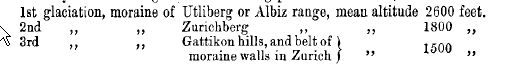
above sea-level, or 1150, 450, and 150 feet above lake-level respectively.inall cases, the moraine rests on molasse. Quite recently I had occasion again to examine these deposits in the company of Prof. Bonney.
page 33 note 2 Among the deposits of the second interglacial period should be further noted the “Löss,” viz. the fine sand and loam which, occurs extensively along the foot of the Jura, as well as in the Rhine valley near Rhinfelden and Basle, and also in the Aare valley near Aaran, and again near the confluence of the Aare and the Rhine, and generally rests on the fluvio-glacial deposits of the second glaciation. By some geologists this Löss has been held to be simply mud, deposited by rivers when in flood; by others as the product of chemical metamorphism; and again by others, such as Professors Richthofen and Muhlberg, as of Æolian origin, viz. as blown Band, this latter theory being the one now in vogue. Further interglacial evidence ia afforded by the so-called lake-chalk of Zurich, viz. the chalk which separates out of the lake water, and a deposit of which was found in the bed of the Limmat at the lower end of the lake, between the moraine of the second and third glaciations.
page 33 note 3 The fluvio-glacial deposits or gravel-beds of the second and third glaciations, which in the North of Switzerland extend along the principal rivers to their confluence with the Rhine, and thence and beyond to Basle, are called by Dr. Du Pasquier the Upper-Terrace and Lower-Terrace Gravels respectively. The moraines of the second and third glaciations are called by Swiss geologists the “outer” and “inner” moraines respectively; Dr. Du Pasquier,indeference perhaps to these time-honoured designations, and also to those of “first and second glacial periods,” or “last” and “penultimate” glaciation, terms the Pliocene (hollow nagelfluh) glaciation the “old” glacial period; I have called them simply first, second, and third glaciations.
page 34 note 1 Peat-moors, such as those in the Glatt valley N.E. of Zurich and on the hills (Zurich berg) which separate that valley and the lake of Zurich, are always an infallible criterion of ground moraiue underlying them. This ground moraine or boulder-clay generally rests on the bottom of pre-glacial molasse valleys; it offers great resistance to the percolation of water and even to fluvial erosion, and remains compact. Hence the soil overlying the boulder-clay does not favour cultivation. Surface moraine or moraine sand, on the other baud, is highly conducive to vegetation, owing to its permeability and the consequent decomposition of alkali producing vegetable matter.