


Introduction
The Batn el-Hagar (Belly of Stone) is a 160km-long stretch of the Nile Valley in Sudan above the Second Nile Cataract where the river passes over a shallow bed in the exposed granite basal complex. Characterised by hyperaridity, a dearth of arable land and a very low carrying capacity, this region appears to have always been a challenging environment, especially since the introduction of agricultural subsistence strategies (Hewes Reference Hewes1966: 42–43). In the area of the Semna Cataract, where our work is focused, larger populations are limited to the Nubian Christian period (AD 641–1400), when new irrigation technology and cultural factors favoured settlement; and the Egyptian Middle Kingdom (2010–1685 BC), when the cataract became Egypt's southern border with the state of Kush (Kerma).
Since 2012, the Uronarti Regional Archaeological Project (URAP) has been excavating the Middle Kingdom fortress of Uronarti, just south of the Second Cataract (Knoblauch et al. Reference Knoblauch, Bestock and Makovics2013; Bestock Reference Bestock2017). The fortress is one of five built by Senwosret III to consolidate economic and military control of the new border zone (Knoblauch Reference Knoblauch and Raue2019) between Egypt and Nubia. Based on earlier survey fieldwork by Mills (Reference Mills1965, 1973; Edwards & Mills Reference Edwards and Mills2013), this zone was previously believed to be sparsely populated, with Egyptian activity restricted to the formal fortress structures and their immediate environs. The URAP implemented a programme of systematic extensive survey of the Western Desert near Uronarti to test this ‘minimalist model’ of Egyptian occupation, documenting over 100 distinct archaeological features, including several sites of Middle Kingdom occupation (Figure 1).

Figure 1. Survey area with sites of interest located.
Methodology
The survey team employed satellite remote-sensing analysis, systematic extensive pedestrian survey, artefact analysis, photogrammetric modelling and architectural recording to locate and document a wide range of archaeological features and artefacts. Data were collected with a bespoke paperless recording system, developed on-site and continually modified throughout the season in response to user feedback (Figure 2).
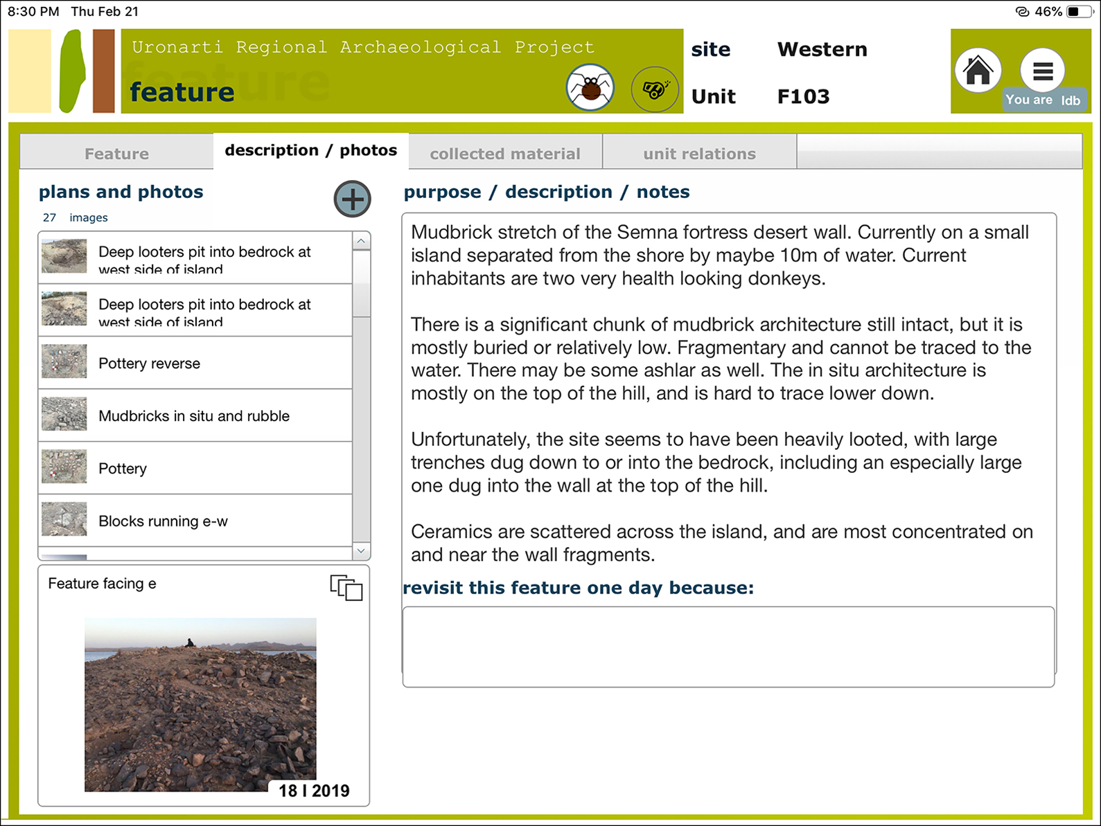
Figure 2. Screenshot of the paperless recording system.
Areas of potential interest were located through visual analysis of pansharpened, high resolution (0.46m) WorldView 2 satellite imagery provided by the Digital Globe Foundation. The images also provided recent data on Nile water levels and landscape change over the past year. The results of this analysis were compared with longer-term data from Google Earth and published data from previous surveys of the area by Steindorff (Felber et al. Reference Felber, Kampp-Seyfried, Spiekermann and Steinmann2000), Vercoutter (Reference Vercoutter1957) and Mills (Reference Mills1965, 1973; Edwards & Mills Reference Edwards and Mills2013). While previous surveys were primarily concerned with low-elevation features close to the pre-dammed route of the Nile, the URAP's investigations focused on features over 180m asl.
Survey data were collected using a structured query language (SQL)-based paperless recording system, accessed through a FileMaker Go user interface and facilitating multimedia data collection and evaluation. This interface was constructed within the framework of the broader URAP recording system (Brown University n.d.), streamlining artefact registration and analysis, and facilitating comparison with excavated material culture and architectural features. Once sites were identified, features were recorded and surface ceramics, lithics and other cultural materials were collected, quantified and documented. This information was entered into the paperless database in real time; ceramics were photographed, and diagnostic sherds collected for analysis.
Select features were recorded in more detail using a combination of photogrammetry and topographic survey; aerial photographs were taken by a kite-mounted Olympus TG-4 camera alongside manual photography using the same camera. These 16-megapixel photographs were processed into three-dimensional models, digital elevation models and orthophotographic meshes with high metric accuracy (Sapirstein & Murray Reference Sapirstein and Murray2017). Spatial referencing was provided by ground control points recorded using Emlid Reach RS+ Real-Time-Kinematic Differential GPS units with a fixed base located at the URAP campsite and a rover collecting corrected data with sub-centimetre accuracy from a distance of up to 6km.
Results
In total, 115 features were documented, in nine survey units. The majority of archaeological features were either small dry-stone constructions (huts), often circular or semi-circular (n = 95), or monumental walls probably associated with the Middle Kingdom fortifications (n = 3). These features were not discrete, however, often being in close proximity to one another. Other documented features included graves, cleared areas, a mortared stone building of uncertain date, modern ephemeral reed-and-wood huts used by local fishermen and at least one area that had been heavily modified by manual surface mining for gold. The water level of Lake Nubia was exceptionally high during the survey, which was undertaken in January 2019, and many features that had been identified previously by the URAP (Knoblauch et al. Reference Knoblauch, Bestock and Makovics2013) were inundated, along with areas normally under intensive cultivation and pasture.
Of note is the rediscovery and documentation of two sections of a monumental defensive wall that ran for 5km along the west bank between the now-submerged fortress of Semna and Uronarti (Edwards & Mills Reference Edwards and Mills2013). As with a comparable Middle Kingdom wall at the First Cataract, documented between Elephantine and Shellal (von Pilgrim et al. 2011: 135–37), the Semna-Uronarti wall was probably intended to protect a heavily utilised land route that bypassed a poorly navigable stretch of the river. Mills (Reference Mills1973: 206, pl. 2) cleaned and documented a section of the Semna-Uronarti wall during his fieldwork, and Knoblauch et al. (2013: 138) recorded a segment that consisted of mud-bricks built directly onto the bedrock. At the two sections of wall currently above water, the URAP noted construction in both mud-brick and stone; the stonework included dry fieldstones, in the higher courses, and cut foundation blocks. The northern section of the wall (F050), stretching some 303m along a ridge, is primarily preserved as a series of parallel dry-stone linear features with occasional exposed mud-brick (Figure 3). The southern section of the wall (F103), extending 106m, consists of a mud-brick superstructure atop regularised and well-built stone foundations (Figure 4). The heterogeneity of construction techniques presumably reflects adaptations by the Egyptian architects to local topography and other variables; for example, the nature of the subsurface and the distance to locally available resources.

Figure 3. F050, Semna Wall north.

Figure 4. F103, Semna Wall south.
Other stretches of dry-stone walling were also noted, often formed by piled stones stretching along ridgelines and saddles (Figure 5). Surface pottery was found at each of these wall features. Interestingly, the dateable surface ceramic assemblage was entirely of Egyptian Middle Kingdom date, and circular dry-stone constructions (huts) were often located in the immediate vicinity (Figure 6). Earlier surveys (Borchardt Reference Borchardt1923: 24; Edwards & Mills Reference Edwards and Mills2013: 10) found a much longer (3km) wall of the same type on the eastern bank near Kumma. Whether such walls were simply a means of regularising or augmenting the topography during the Middle Kingdom, or were related to hunting activities, as in Middle Nubia where such walls are common (Edwards & Mills Reference Edwards and Mills2013: 10), is difficult to determine on current evidence.

Figure 5. S005 and other features detected with WV2 imagery.

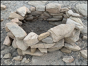
Figure 6. F082, a ‘typical’ circular dry-stone structure.
The URAP also recorded several ridgetop clusters of dry-stone features, along with numerous other constructions across the landscape built from local bedrock. Small assemblages of surface artefacts were occasionally recorded in association with these features, and all diagnostic ceramic sherds were exclusively of Middle Kingdom date. Infrequent chipped- and ground-stone tools were also recorded, most probably alluding to on-site food preparation (hunting or grain processing) during this same period. Artefacts firmly dating to other periods were notably absent, other than traces of modern local lifeways (clothing, medicine, butchered animals, fishing nets and the like).
Implications
Perhaps the most important trend in our survey results is the proliferation of Egyptian pottery beyond the immediate environs of the Uronarti fortress, associated with dry-stone architecture at elevations far removed from the ancient course of the Nile. Combined with the extra-mural stone settlement that the URAP documented on Uronarti Island (Bestock & Knoblauch Reference Bestock and Knoblauch2015), these finds suggest that the Egyptian presence in this inhospitable border region was diverse, and certainly not confined to the formal fortress structures as hitherto believed. Determining discrete functions for these sites is difficult without excavation, and more systematic survey is required to highlight settlement patterns on a diachronic scale. Future field seasons will extend this survey in both the Eastern and Western Deserts. Excavation of select dry-stone structures recorded in 2019 will also be incorporated in order to understand the function of these features and their direct relationship with material culture emanating from nearby fortresses.
Acknowledgements
The authors would like to thank the Sudan National Corporation of Antiquities and Museums—in particular Elnzeer Tirab—and the members of our survey team: Abigail Stoner, Allison McCoskey, Anna Soifer and Lyndelle Webster. Many thanks to the DigitalGlobe Foundation for providing satellite imagery. Finally, we thank the many local fishermen and shepherds who kindly facilitated our research and provided welcome hospitality in the Western Desert.


