


Introduction
Excavation between 1977 and 1981 of a cropmark at Balbridie, Aberdeenshire, Scotland (Figure 1), revealed a substantial timber hall of a form previously only associated in Scotland with buildings of early medieval date. Radiocarbon dating, however, revealed the hall to date to the Early Neolithic period (in Scotland, c. 3800–3300 cal BC) (Fairweather & Ralston Reference Fairweather and Ralston1993). The site is remarkable not only for the outstanding evidence of this timber building, but also for the exceptional preservation of substantial quantities of carbonised grain within the negative features of the structure. As part of the ongoing post-excavation and full publication of the site, the opportunity arose to reassess the nature of this cereal assemblage using analytical techniques that were unavailable at the time of recovery and its initial archaeobotanical analysis. Here, we report on the first stable isotope analysis of the cereals from Balbridie, alongside stable isotope analyses of archaeobotanical material from three other Neolithic assemblages: Skara Brae, the Braes of Ha'Breck and Dubton Farm (Figure 1; for site descriptions, see below). These analyses provide the opportunity to explore crop-growing conditions in contrasting environmental settings, from north-east Scotland (Balbridie and Dubton Farm) to Orkney (Skara Brae and Braes of Ha'Breck), and to compare agricultural practices during different phases, from the earlier fourth (Balbridie and Dubton Farm phase 1) to later fourth (Skara Brae, Braes of Ha'Breck and Dubton Farm phase 2) millennium BC. We measured the length, width and depth of 196 Neolithic cereal grains from these sites before undertaking carbon and nitrogen stable isotope analysis on each grain (for the methods used, see the online supplementary materials (OSM)) to examine crop-growing conditions and to assess the extent to which grain size reflects growing conditions or landrace type (i.e. crop variety). The results of the isotope analyses, together with new ecological analyses of the archaeobotanical data from these sites, provide novel insights into the nature of early farming practices in North-west Europe.

Figure 1. Location of study sites (figure by R.R. Bishop and P.A. Rowley-Conwy).
Reconstructing cultivation strategies
The stable isotope composition of archaeological crop remains provides a direct method of investigating growing conditions in the past, potentially allowing variation within and between harvests to be identified (Bogaard et al. Reference Bogaard2013). Modern field trials have revealed that stable nitrogen (δ15N) and carbon (δ13C) isotope compositions in crop remains reflect, respectively, the application of nitrogen-enhanced organic matter (manure, household midden, seaweed or fish remains) and the varying availability of water (e.g. Bogaard et al. Reference Bogaard2013; Wallace et al. Reference Wallace2013; for further detail, see OSM1). Manuring implies a long-term investment in the land, which would have increased productivity for crops grown repeatedly on the same plot without the need to employ shifting (slash-and-burn) cultivation methods (Bogaard et al. Reference Bogaard2013). Ecological data from crop weeds in archaeobotanical assemblages can also permit differentiation of permanent (more annuals and disturbed ground taxa) and shifting (more perennials and woodland taxa) cultivation, where sufficient weed seeds are available in archaeobotanical assemblages (Bogaard Reference Bogaard2002).
Neolithic farming in Britain
Extensive archaeobotanical investigations over the past 50 years have revealed much about the relative roles of different cereal crops in the subsistence practices of Neolithic farmers in Britain (Jones & Rowley-Conwy Reference Jones, Rowley-Conwy, Colledge and Conolly2007; Bishop et al. Reference Bishop, Church and Rowley-Conwy2009; Treasure et al. Reference Treasure, Gröcke, Caseldine and Church2019). Relatively little, however, is known about Neolithic cultivation methods, including where and how cultivation was practised and the social geography of crop production. At one extreme, it has been proposed that Early Neolithic populations were semi-mobile pastoralists, who grew cereals only sporadically and/or in transient plots with limited management (e.g. Thomas Reference Thomas2013: 400–402); at the other extreme, it has been argued that crops were cultivated intensively, in permanent plots located beside settled farmsteads (e.g. Bogaard & Jones Reference Bogaard and Jones2007; Rowley-Conwy et al. Reference Rowley-Conwy, Gron, Sørensen and Rowley-Conwy2020). It has also been suggested that cereal agriculture was largely abandoned by the Late Neolithic across Britain and Ireland (Stevens & Fuller Reference Stevens and Fuller2012), although this proposal has been disputed with reference to Scotland, where there is evidence that cultivation continued to be important (Bishop Reference Bishop2015).
The cereal remains recovered from Balbridie, along with those from recent excavations at the Neolithic settlement at the Braes of Ha'Breck on Wyre, Orkney (Thomas & Lee Reference Thomas and Lee2012), provide key evidence in relation to these debates. Together, the assemblages consist of tens of thousands of grains, representing two of the largest Neolithic cereal assemblages from North-west Europe. Thus, in conducting isotope analyses of these important assemblages, we aim to address the following questions: was cultivation long-lasting or transient? Were crops grown intensively in small plots or extensively over larger areas? Do the crop remains represent single or multiple harvests? Were different crops grown separately as unmixed stands or were they sown as maslins, with several crops grown and harvested together? And how do these new data relate to the evidence of Neolithic subsistence strategies across North-west Europe more widely?
Crop-growing conditions in Neolithic Scotland
Balbridie
During the thirty-eighth or thirty-seventh centuries cal BC (see Bayesian modelling of radiocarbon dates by Whittle et al. Reference Whittle, Healy and Bayliss2011: 833), the rectangular timber-built hall at Balbridie burnt down, preserving Early Neolithic pottery and more than 20 000 cereal grains within the postholes and construction trenches of the building (Fairweather & Ralston Reference Fairweather and Ralston1993). The cereal assemblage is dominated by emmer wheat (Triticum dicoccon Schrank), but also features substantial quantities of naked barley (Hordeum sp. naked) and free-threshing wheat (T. aestivum L./T. turgidum L./T. durum Desf.) (Figures 2 & 3). No zooarchaeological remains were recovered, probably due to the acidic soils of the area, which prevent bone preservation.

Figure 2. Plan of negative features at Balbridie, showing distribution of cereals by feature (data from Fairweather & Ralston Reference Fairweather and Ralston1997). F294 and F40 are the features analysed in the isotope study (figure by R.R. Bishop).

Figure 3. Cereal data for the contexts analysed in the isotope study. n = number of grains analysed (figure by R.R. Bishop).
The results of the stable isotope analyses from Balbridie have produced surprising results (Figures 4 & 5), which contrast with the generally accepted model for European Neolithic farming based on cultivation in manured and intensively managed, long-lived plots (Bogaard et al. Reference Bogaard2013). The majority of the δ15N values for crops at Balbridie are at or below the natural baseline for the area (Figure 4); these low δ15N crop values (mean: 0.6‰±1.1; range: –1.6‰ to +3.7‰) suggest that the crops were grown on soils that had not been manured, or that had received minimal inputs of manure or other fertilisers for several years. It is also possible that the cereals were grown on recently established and manured plots, as crop isotope values do not necessarily increase in the first season following the application of manure (Fraser et al. Reference Fraser2011), or, alternatively, on unmanured ground as part of a slash-and-burn system, as land recently cleared by burning may produce relatively low δ15N crop values (Styring et al. Reference Styring2017: 372). In either of the latter two cases, weed data indicative of recently cleared forests might be expected (Bogaard Reference Bogaard2002); the wild seeds from Balbridie, however, consist primarily of annuals and taxa associated with disturbed land and grasslands (Figures 6 & 7; Table S1; for further discussion, see OSM3). The combined data from the cereals and weeds are therefore consistent with cultivation on well-established (>10 years) arable land, managed without manuring, implying that local soils were sufficiently productive without the use of fertilisers during this initial farming phase.

Figure 4. Crop stable isotope results for the study sites (figure by R.R. Bishop).

Figure 5. Summary of cereal grain sizes and crop stable isotope values for the study sites (figure by R.R. Bishop).

Figure 6. Habitat associations for wild seed taxa for study sites. n = number of seed taxa. NB: the Skara Brae wild seed assemblage post-dates the cereal assemblage (figure by R.R. Bishop).

Figure 7. Annual and perennial wild seed taxa proportions for study sites. n = number of seed taxa (figure by R.R. Bishop).
The capital delta carbon stable isotope values (Δ13C: calculated from δ13C to allow for changes in atmospheric δ13C over time and to enable comparison between sites; see OSM1) range from 15.9 to 19.3‰ (mean: 17.5‰±0.8; Figures 4 & 5), with most of the grains falling in the moderate- to well-watered range, as identified through experiments with modern crops (Wallace et al. Reference Wallace2013). In line with these studies, the wheat grains from Balbridie tend to have lower Δ13C isotope values (indicating lower water availability or increased light intensities during growth: see OSM1) than the barley grains, which is thought to reflect the fact that wheat continues to photosynthesise later into the summer than barley whilst soils are drier and light intensity is higher (Wallace et al. Reference Wallace2013).
Experiments show that the range in isotope values for cereal grains grown in a single field in the same year can be as high as 5‰ δ15N and 1.5‰ δ13C (Heaton et al. Reference Heaton, Jones, Halstead and Tsipropoulos2009; Fraser et al. Reference Fraser2011, Reference Fraser2013; Wallace et al. Reference Wallace2013). At Balbridie, the δ15N isotope values for the crops are uniformly low (i.e. they vary by less than 5‰) and suggest that all three species were grown on similar soils, perhaps within the same field (Table S3). The range in δ13C values for the crops (Table S3), however, is greater than would be expected if all the grain had been grown under the same conditions (i.e. greater than 1.5‰), suggesting either: (a) crops that were grown in plots with different micro-environments (e.g. soils with differing water-retention capacities and/or light conditions, for example, shade from vegetation); and/or (b) cereals from multiple harvests, reflecting inter-annual variation in weather, for example, rainfall. In either case, a level of management to ensure resilience in crop production is evident: sowing in diverse parts of the landscape would have reduced the risk of losing an entire crop, while the storage of multiple harvests would imply that surplus grain was retained for more than one year, ensuring against crop failure.
The quantity and dominance of free-threshing wheat in post feature F40 suggests that this crop species was deliberately cultivated, harvested and stored in a specific part of the building (Figure 2; Fairweather & Ralston Reference Fairweather and Ralston1993). In contrast, with the exception of one feature (F313) where the cereal assemblage is dominated by naked barley, archaeobotanical material from the building's post features are dominated by emmer (approximately 50–85 per cent), with variable, but lower proportions of naked barley (approximately 10–50 per cent) (see Figure 2). The consistency of these proportions in the different features across the building implies that the crops were grown as maslins (multiple crops grown together), rather than as two separate crops, which were then subsequently mixed during storage in the building.
A range of scenarios could explain the low δ15N values for crops from Balbridie. One interpretation is that animal husbandry was not a major part of the economy and thus little animal manure was available. Alternatively, animals may have grazed in the wider landscape throughout much of the year, reducing manure availability for fertilising crops grown closer to the building. Another possibility is that both crops and animals were kept near the building, but that the manure was not used for crop fertilisation. However the results are interpreted, the significant number of cereal grains recovered and their relatively large sizes suggest that local soils were sufficiently productive for crop cultivation without the need for manuring (Figure 5). J.C.C. Romans classified the soils from the turf packing in the building's construction trenches as a brown earth in the initial stages of podsolisation (Fairweather & Ralston Reference Fairweather and Ralston1993)—that is, a free-draining soil with high levels of natural fertility (James Hutton Institute 2021). Field trials also show that, although manuring increases crop yields significantly, it is possible to maintain moderate yields over the short- to long-term without the use of manure (Reynolds Reference Reynolds and Anderson1999).
Dubton Farm
In contrast to Balbridie, the site at Dubton Farm, Angus, consists of an isolated series of pits of large (phase 1: c. 3940–3659 cal BC) and small (phase 2: c. 3640–3374 cal BC) size, with no associated structures (Cameron Reference Cameron2002). The archaeobotanical assemblage also differs in that it contains substantial quantities of cereal chaff and weed seeds, as well as a mixture of emmer wheat, naked barley and free-threshing wheat grain (Figure 3; Church Reference Church and Cameron2002). As at Balbridie, no evidence for animal husbandry was identified, though acidic soils again prevent bone preservation.
The δ15N isotope values for crops at Dubton Farm range from –0.9 to 6.5‰ (mean: 3.2‰±1.6) and are consistent with low-to-moderate levels of manuring, fitting well with the wider North-west European dataset (Figures 4–5 & 8) and the model of intensive cultivation in permanent plots (cf. Bogaard et al. Reference Bogaard2013). Waterlogging and slash-and-burn cultivation are unlikely causes of the moderate to high δ15N isotope values for crops because wet indicator species and woodland taxa are absent from the wild seed assemblage and annual taxa are dominant (Figures 6 & 7). The Δ13C values range from 16.7 to 21.1‰ (mean: 18.7‰±0.9), suggesting the crops were predominately moderately- to well-watered (cf. Wallace et al. Reference Wallace2013). The ranges of δ15N and Δ13C stable isotope data for crops from the two phases of the site overlap and there are no clear differences between the phases (Table S4).

Figure 8. Crop stable isotope values for Neolithic sites in North-west Europe (figure by R.R. Bishop).
The relatively wide ranges in the carbon and nitrogen stable isotope values of crops from Dubton Farm suggest that the grain was grown in a variety of conditions, most likely in different fields (individual crop ranges in δ15N >5‰ and in δ13C >1.5‰) (Table S3). Moreover, experiments show that barley Δ13C is typically 1–2‰ higher than wheat when grown on the same soils (Wallace et al. Reference Wallace2013); the virtually identical mean Δ13C isotope values for wheat (18.6‰) and barley (18.9‰) from Dubton Farm therefore also support the suggestion that the two crops were cultivated in separate fields, with barley grown on slightly drier soils and, if locally grown, perhaps within the free-draining and fertile brown earth soils of the area (James Hutton Institute 2021; Scotland's Soils n.d.). The variable crop isotope data most likely reflect mixing of different harvests from different crops and different harvest years within the pits.
Skara Brae and the Braes of Ha'Breck
The UNESCO World Heritage Site of Skara Brae on Orkney's west Mainland, a surviving complex of stone-built structures, preserves an outstanding record of Neolithic society and economy (Clarke & Sharples Reference Clarke, Sharples and Renfrew1990; Shepherd Reference Shepherd, Hunter and Sheridan2016). The two main phases of this settlement (Phase 1: c. 2910–2880 to 2860–2840 cal BC, Phase 2: c. 2800–2700 cal BC to 2550–2420 cal BC; Shepherd Reference Shepherd, Hunter and Sheridan2016) each encompassed six to eight buildings, surrounded by accumulated construction and occupation deposits, including two specific midden agglomerations (Shepherd Reference Shepherd, Hunter and Sheridan2016). In 1972–1973, a small cereal assemblage, predominantly of naked barley, together with some emmer wheat and hulled barley (Hordeum sp. hulled), was recovered from an early phase of occupation (Phase 0, c. 3360–3160 cal BC) underlying this main settlement (Figure 3) (Shepherd Reference Shepherd, Hunter and Sheridan2016; Rowley-Conwy & Bishop Reference Rowley-Conwy and Bishop2021). In addition, a large assemblage of wild seeds was recovered from the two main phases of the settlement, which post-date the Phase 0 cereal assemblage (Figures 6 & 7).
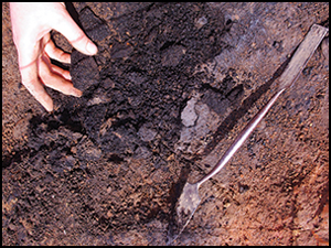
The site at the Braes of Ha'Breck is located on Wyre, a small island (approximately 1.5 × 2.5km) north of Mainland, Orkney (Thomas & Lee Reference Thomas and Lee2012; Farrell et al. Reference Farrell, Bunting, Lee and Thomas2014). The settlement comprises two timber-built and three stone-built structures, with evidence for several phases of construction, an external working floor, and occupation deposits, including midden deposits (Thomas & Lee Reference Thomas and Lee2012). Bayesian modelling of the radiocarbon dates indicates that occupation began c. 3585–3375 cal BC and ended c. 3270–2980 cal BC (Bayliss et al. Reference Bayliss, Marshall, Richards and Whittle2017). Within one of the stone-built structures was a layer of carbonised grain (dated to 3090–2920 cal BC; Garrow et al. Reference Garrow, Griffiths, Anderson-Whymark and Sturt2017)—perhaps a store accidentally burnt in a house fire (Figure 9) (Thomas & Lee Reference Thomas and Lee2012; Bishop Reference Bishop2013). This assemblage, which comprises hundreds of thousands of grains, is one of the largest Neolithic cereal assemblages in North-west Europe (Bishop Reference Bishop2015). Elsewhere on site, charred cereals, almost exclusively of naked barley, together with scarce emmer wheat and hulled barley, were recovered in moderate concentrations from a range of negative features, occupation deposits and hearths (Figure 3) (Bishop Reference Bishop2013). Both sites produced evidence for cattle and sheep/goat husbandry, with pig also recovered in smaller quantities from Skara Brae (Clarke & Sharples Reference Clarke, Sharples and Renfrew1990: 75; Thomas & Lee unpublished data).

Figure 9. The grain-rich layer at the Braes of Ha'Breck: A) location of the main concentration of grain in the north end of house 3; B & C) detail of carbonised grain in house 3 (photographs and plan by A.S. Thomas and D.H.J. Lee).
The δ15N isotope values for the crops at Skara Brae range from 0.9 to 5.3‰ (mean: 3.2‰±1.1) (Figures 4 & 5) and are consistent with low-to-moderate levels of manuring (cf. Bogaard et al. Reference Bogaard2013). At the Braes of Ha'Breck, there is considerable variation in the δ15N isotope values for the crops (mean: 3.9‰±2.3; range: 0.2‰ to 13.7‰)—greater than at any other site considered here—indicating low, moderate and high levels of manuring. The medium and high δ15N isotope values are unlikely to result from waterlogging. Though no wild seeds were recovered in association with the cereals at Skara Brae (Rowley-Conwy & Bishop Reference Rowley-Conwy and Bishop2021), the Δ13C isotope values for the crops from the site indicate relatively dry growing conditions (Figure 4), consistent with growth in the sandy soils of the area (see below). Furthermore, at the Braes of Ha'Breck, seed indicators of wet growing conditions are relatively rare (see Figures 6 & 7; Table S1).
Most of the data from both Orcadian sites fall within the ‘moderate manuring’ range (Figure 4), consistent with the dataset for early cereal agriculture across North-west Europe (Figure 8). This suggests that these crops were mainly cultivated in permanently maintained plots fertilised with nitrogen-enhanced organic material. The consumption of grain from these manured crops could partly explain the relatively high δ15N values observed in Neolithic human remains from Orkney (Schulting et al. Reference Schulting, Sheridan, Crozier and Murphy2010).
The very high δ15N isotope values from the Braes of Ha'Breck (8.8‰ and 13.7‰; see Table S5) are most likely explained by the addition of nitrogen-enhanced organic matter to the soils. The alternative of cultivation directly on a midden, as has been suggested for Neolithic Orkney at Tofts Ness (Guttmann et al. Reference Guttmann, Simpson, Davidson and Dockrill2006), is both logistically impractical due to unstable surfaces on middens and strategically undesirable because of the likely adverse effects of exploiting such high nitrogen conditions, which would have risked lodging and loss of the crop (cf. Briggs Reference Briggs1978: 302–308). The grains were well preserved, and the samples were reanalysed to ensure accuracy, so charring at high temperatures or analytical error is unlikely, although contamination cannot be ruled out (see OSM2). Similarly high δ15N isotope values for Neolithic naked barley were obtained from Frydenlund in Denmark (13.8‰) (Gron et al. Reference Gron2021) and Oldenburg LA77 in Germany (13.9‰) (Filipović et al. Reference Filipović2019), which the latter authors suggest might reflect the use of seaweed fertiliser or manure from seaweed-eating herbivores. The impact of fertilising crops with manure from herbivores with marine diets has yet to be assessed, and crop trials of hulled barley in Orkney using seaweed fertiliser have not produced δ15N crop isotope results above 5.6‰ (Blanz et al. Reference Blanz2019). The latter result, however, might be explained by the seaweed and soil in this study having similar δ15N values, with recent experiments by Gröcke and colleagues (Reference Gröcke2021) demonstrating a significant increase in δ15N (up to 15‰) for beans grown in soils fertilised with seaweed and marine fish rich in nitrogen.
The Δ13C values at Skara Brae (14.6–17.9‰; mean: 16.2±0.9) are notably lower than at the Braes of Ha'Breck (16.1–19.8‰; mean: 17.8±0.8) and the other sites considered here (Figures 4 & 5). This probably reflects the relatively low water-retention capacity of the calcareous windblown sands at Skara Brae (Simpson et al. Reference Simpson, Guttmann, Cluett and Shepherd2006; Scotland's Soils n.d.) and/or the higher soil salinity resulting from salt spray—both factors that lower Δ13C values (see OSM1). In contrast, Wyre lacks the windblown sand deposits of west Mainland, Orkney, and today the Braes of Ha'Breck is located within an area of non-calcareous gleys, which are a less well-drained soil type (Scotland's Soils n.d.). Other factors, such as increased openness of the landscape (Heaton Reference Heaton1999), are an unlikely cause of the lower Δ13C values at Skara Brae, since pollen evidence suggests that both sites were located in relatively open conditions (Fyfe et al. Reference Fyfe2013). Drier soils, and hence lower Δ13C values, have also been linked to more steeply sloping topography in semi-arid regions, where water-stress was potentially an issue (Bogaard et al. Reference Bogaard2016). Here, however, altitude/slope is unlikely to have been a significant factor, given Scotland's relatively wet climate (see also Gröcke Reference Gröcke1998: 3). Nevertheless, lower rainfall at Skara Brae as a result of changing climate remains a possibility, as the date ranges for the two crop assemblages do not quite overlap. The relatively higher Δ13C values for Balbridie and Dubton Farm—both located inland and well away from saline environments—might reflect greater levels of shading by vegetation, since woodland was more extensive on mainland Scotland than Orkney (Fyfe et al. Reference Fyfe2013; Farrell et al. Reference Farrell, Bunting, Lee and Thomas2014).
The grain from the Orkney sites tends to be smaller than that from the mainland sites (Figure 5). Significantly, there is no correlation between grain size and δ15N or Δ13C isotope values (Figure S1), so these size differences do not reflect manuring rates or the availability of water (Figure 5). Recent studies support this, suggesting that barley grain morphology and size are influenced more by landrace type than growing conditions (e.g. Wallace et al. Reference Wallace2019). The size differences could therefore reflect adaptations to the local conditions (e.g. rainfall, exposure, soil type), perhaps representing the development of separate landraces for Orkney and mainland Scotland. As the Orcadian assemblages are several centuries later in date than Balbridie and Dubton Phase 1, it is also possible that there was size reduction over time.
The range in δ15N values for the available data suggests that the Skara Brae cereals were all grown under the same conditions (individual crop ranges all <5‰), whereas the Braes of Ha'Breck crops were not (individual crop ranges >5‰; Table S3). Caution should be exercised here, however, as this apparent difference may be due to the comparatively low number of grains recovered and the relatively low isotope sample size from Skara Brae. Nonetheless, the range in crop δ13C values for both sites is greater than might be expected if all the grain had been grown together (individual crop ranges all >1.5‰; Table S3). The variable carbon stable isotope values from Skara Brae probably reflect the mixing of different harvests within the deposits. It is likely that animal manure was intentionally spread on fields by people rather than directly by animals grazing on fallow cereal plots; Neolithic domestic herbivore δ15N values for Orkney are typically between 6 and 7‰ (and for Skara Brae the mean sheep δ15N value is 6.5‰), which are comparable to those obtained for wild herbivores in the region (δ15N typically approximately 6‰; Jones & Mulville Reference Jones and Mulville2016: 672). This suggests that cattle/sheep consumed little cereal chaff from manured crops.
Notably, the nitrogen and carbon stable isotope values for crops from the conflagration deposit at the Braes of Ha'Breck are just as variable as the values from the other contexts (Table S4), suggesting that the deposit contains multiple stored harvests, or grain grown in different microenvironments. The variable manuring of different harvests, however, does not fully account for the variation in δ15N values. Experiments have shown that after manuring ceases, δ15N values for crops grown on previously manured soils can take many decades (approximately 70 years) to return to unmanured levels (Fraser et al. Reference Fraser2011: 2796). The wide range of values recorded here therefore suggests that crops were grown in a range of locations in the surrounding landscape. This fits with the initial analysis of the potential arable weeds, which suggests cultivation on soils with variable levels of fertility (Bishop Reference Bishop2013). It is important to consider the small size of the island, which may have provided relatively restricted locations for optimal cultivation and limited options for wild plant collection. It is possible that crops were therefore grown extensively across the island to buffer against crop failure. Similarly, hazelnut shells are exceptionally rare in the assemblage, suggesting that the gathering of wild plants was not integral to the economy of this site (Bishop Reference Bishop2013). Alternatively, the conflagration deposit may represent a communal store for different households, perhaps including communities on neighbouring islands that had access to different amounts of animal manure and/or land with different levels of fertility. Although no other Neolithic settlements have been discovered on Wyre, the neighbouring island of Rousay features the Skara Brae-style settlement of Rinyo, in addition to a dense concentration of Early Neolithic chambered cairns (Davidson & Henshall Reference Davidson and Henshall1989), suggesting a relatively well-populated landscape.
International research context
The Balbridie cereal data contrast with the results from Lismore Fields, another British Early Neolithic timber-built settlement, which demonstrate relatively high rates of manuring, but are similar to the low δ15N isotope values for cereals identified for four Early Neolithic sites in Wales and those from the monumental enclosure at Sarup in Denmark (Figure 8) (Bogaard et al. Reference Bogaard2013; Treasure et al. Reference Treasure, Gröcke, Caseldine and Church2019). Nonetheless, taken as a whole, the dataset from the four sites examined here shows that soil amendment strategies in Neolithic Scotland were similar to those employed elsewhere in Europe at that time, with evidence for cultivation on a range of different soils with variable δ15N levels (Bogaard et al. Reference Bogaard2013). This indicates that a variety of cultivation strategies was implemented across North-west Europe, perhaps according to the natural fertility of different soils, the extent of stock-keeping and the availability of manure, as well as access to labour and the crop management expertise of these early farmers.
The low Δ13C values at Skara Brae, together with the generally low values at the other three sites, are surprising, considering both the relatively wet Scottish climate and the wider European dataset (Figure 8). These results seem to suggest that, in addition to water availability and manuring level, other factors, such as soil type and soil salinity, substantially influence the Δ13C values of crops. Consequently, models for interpreting crop Δ13C levels based on Mediterranean environments (e.g. Wallace et al. Reference Wallace2013) probably need further refinement before application to crop remains from North-west Europe. Specifically, the relatively low and variable Δ13C results from the case studies presented here highlight the need for further research into the factors affecting crop Δ13C variability in non-arid regions.
Conclusions
The large-scale application of stable isotope analysis to archaeobotanical assemblages from Neolithic sites in Scotland provides new insights into agricultural practices in North-west Europe. The new data from Balbridie reveal that cereals were successfully cultivated in well-established plots without manuring, implying that local soils were naturally productive during this initial farming phase. At other sites in Scotland, cultivation practices were similar to those implemented elsewhere in Neolithic Europe, involving intensive manuring of permanent plots, and indicating a sustained investment in the productivity of the land. At Balbridie, cereals appear to have been consistently planted in fairly uniform soils, but at other sites (e.g. Braes of Ha'Breck) there is evidence that the cereals were grown on a range of soils, suggesting that cultivation was undertaken over a larger area than is often assumed for Neolithic Britain, or that there was a degree of cooperation in crop storage between households. The evidence for the storage of harvests from different microenvironments and/or years within the structures at Balbridie and the Braes of Ha'Breck implies that Neolithic farmers implemented measures to buffer against crop failure, creating a level of economic resilience to environmental and social uncertainty. The variability of the cropping strategies identified highlights the adaptability of early farming practices, and the potential of stable isotope analysis of cereals for recognising past sustainable (and unsustainable) land use elsewhere across the globe; in turn this may provide lessons for managing future human impacts on the environment. It also emphasises the importance of analysing material from multiple early farming sites, as a single site may not be representative of the range of cultivation practices across a large region. Finally, the results highlight the idea that farming in Scotland was both stable and well-adapted to the changeable climatic conditions of the fourth and third millennia cal BC.
Acknowledgements
Many thanks to Kirsty Cameron for advice on Dubton Farm and to the reviewers for their useful comments.
Funding statement
Stable isotope analyses were funded by the Department of Archaeology and Stable Isotope Biogeochemistry Laboratory (SIBL) at Durham University through MJC and DRG, respectively. Open Access funding was provided by the Universitetet i Stavanger, Norway.
Supplementary materials
To view supplementary material for this article, please visit https://doi.org/10.15184/aqy.2022.107.


 Open access