


Introduction
The study of military and caravan structures along the eastern Roman frontier has received renewed attention, thanks in part to the application of new research techniques (e.g. Hildebrandt et al. Reference Hildebrandt, Shamir, Galili, Shamir and Bar-Oz2023; Fradley et al. Reference Fradley, Wilson, Finlayson and Bewley2023). Results have highlighted the need to shift from limited aspects of a site, such as just its physical remains, towards its longue durée and the monitoring of preservation threats; this is particularly required for cultural heritage in the Middle East and North Africa (MENA). Recently, the fort and caravanserai at Khirbet al-Khalde in southern Jordan was investigated with these factors as a backdrop (Figure 1); the results connected to the site's ongoing resilience and destruction are presented here.

Figure 1. Map of region, showing location of site (image from the Khirbet al-Khalde Archaeological Project).
Multiscalar survey and cultural heritage protection
The site at Khirbet al-Khalde, 26km north-east of Aqaba in the Wadi al-Yutm, encompasses a fort, a caravanserai, two watchtowers, cisterns, an aqueduct and cemeteries (Figure 2).

Figure 2. Drone imagery of site with important features highlighted (image from the Khirbet al-Khalde Archaeological Project).
These remains have suffered extensive damage from modern disturbances, including looting and bulldozing (Figures 3 & 4). The area was visited by travellers and archaeologists in the nineteenth and twentieth centuries, and their reports are crucial to understanding the site's general chronology and its function as a military and trade station along this frontier (Kennedy Reference Kennedy2002). However, despite the site's significance and earlier work (e.g. De Backer & Scott Reference De backer and Scott2015), the new survey is the first systematic archaeological investigation with focus on site chronology, high-definition mapping, resilience and resource exploration, and an assessment of damage to its archaeological remains. In addition to surface collection, the investigation included architectural survey, 3D modelling of features, drone imaging, damage assessment and a restudy of reports, travel accounts, photographs and earlier satellite imagery.

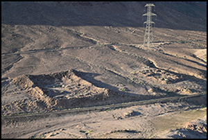
Figure 3. Overview of main site, facing south (photograph by Khirbet al-Khalde Archaeological Project).

Figure 4. Composite image of Roman fort and presumed caravanserai (figure by Khirbet al-Khalde Archaeological Project).
Here, we use case studies to highlight the potential of an integrative survey approach, which is also of benefit in non-conflict zones where damage to sites resulting from urban sprawl, modern developments and looting has significantly increased in the past decades (e.g. Stott et al. Reference Stott, Kristiansen, Lichtenberger and Raja2018).
Disentangling modern disturbances
The north-east-oriented fort at Khirbet al-Khalde features four corner towers which, like the rest of the structure, have collapsed. Bisheh et al. (Reference Bisheh, Farajat, Palumbo and Waheeb1993: 124–25) stated in their publication that the northernmost tower had been partly destroyed by bulldozing. We confirmed this observation, but also assessed that the entire area north-east of the fort had been heavily bulldozed on several occasions. One bulldozing event occurred during the construction of the railroad, which runs alongside the north-west wall of the fort and comes within 10m of its remains. The area in front of the fort carries traces of bulldozing and the find-rich surface shows that archaeological material has been moved around extensively to create a level surface for constructing the railroad. During this process, the tower was probably partly bulldozed.
The Hunting Aerial Survey of Jordan in 1953 contains two aerial photographs of the site. Neither of these show any major damage to its remains, although the Desert Highway is clearly visible to the west of the site (Figure 5A). Satellite images from the Corona database taken in 1967 also show no traces of major damage to the site (Figure 5B). With the construction of the railroad, from 1975 onward, access to the site and broader local and regional knowledge of its remains improved, which in turn also facilitated its looting. This access and familiarity no doubt further increased after the later commissioning of the electrical transmission line and its access road, which bisects the site to the south-east of the fort. During the recent survey, approximately 50 looters’ pits of varying sizes around the main structures were documented (Figure 6) in addition to a heavily disturbed cemetery to the north-east. It had at least 44 graves, all of which were illicitly dug into at some point after the date of the corona images (Harvey et al. Reference Harvey, Intagliata, Mokránová, Raja and Zoppiin press).

Figure 5. A) aerial photograph of Khirbet al-Khalde from 1953 (photograph by Hunting Air Survey, courtesy of Aerial Photographic Archive for Archaeology in the Middle East); B) Corona satellite image (United States Geological Survey (USGS), Earth Resources Observation and Science (EROS) Center Archive).

Figure 6. Drone imagery of main site showing locations of disturbance (image from the Khirbet al-Khalde Archaeological Project).
Water infrastructure as chrono-resilience indicator
In this project, the site's aqueduct, which connects the fort to a spring approximately 1km to the south-east, was studied to assess chrono-resilience and resource management. In 1939, Stein recorded this aqueduct, but his description lacks detail and presents several misinterpretations (Gregory & Kennedy Reference Gregory and Kennedy1985: 312). In 2023, our survey traced the aqueduct's line and mapped its route with a total station and handheld Garmin GPS. Visible sections of the aqueduct were photographed and described, and loose pipe and mortar samples were collected. In addition, the aqueduct's route was photographed in high resolution by a drone (Figure 3).
The combination of the pedestrian and drone surveys has allowed for precise mapping of the aqueduct's course, documenting its method of construction and assessing its condition in unprecedented detail. With the exact route of the aqueduct and its topography mapped in high resolution and the ceramic water pipes carefully documented, it is now possible to assess the gradient of the water channel and its flow rate in greater detail than was previously possible. This will enable a better understanding of the water resources that were available at the site to support its development.
Another outcome of this multiscalar approach was the identification of several misinterpretations and omissions by Stein during his survey of the aqueduct. Neither Stein nor any other early explorer of the site noted the presence of the stone-built and plastered water tank at the source of the spring. In addition, Stein and others noted the presence of a ‘reservoir’ approximately halfway along the line of the aqueduct, but our assessment of this structure suggests that it was not hydraulic in nature, but rather a stone constructed enclosure pre-dating the construction of the aqueduct.
Conclusion
Our integrative survey approach has resulted in deeper understanding of Khirbet al-Khalde and its chrono-resilience through a multiscalar approach, including the archaeometric survey, making of precise plans as well as a detailed damage assessment, which made clear how the site's preservation has deteriorated since the early twentieth century. The construction of the railroad caused significant damage to the structures through bulldozing and increased access to the site, which also facilitated looting. The existence of numerous looting pits within the small area of 0.8ha underlines an urgent need for archaeological and preservation work. The documentation of modern disturbances has proved crucial to define research plans and goals by identifying areas most at risk and will guide future archaeological research at Khirbet al-Khalde.
Acknowledgements
The Khirbet al-Khalde Archaeological Project is funded by the Augustinus Foundation and the Carlsberg Foundations and the Danish National Research Foundation (DNRF119) and an American Center of Research grant (S. Thomas Parker Memorial Fund). The directors thank the Department of Antiquities of Jordan and ACOR for support.


 Open access