Hostname: page-component-76fb5796d-dfsvx Total loading time: 0 Render date: 2024-04-26T22:47:23.894Z Has data issue: false hasContentIssue false

Maritime endangered archaeology of the Middle East and North Africa: the MarEA project

Published online by Cambridge University Press:  01 December 2020

Georgia Andreou*
Affiliation:
Department of Archaeology, University of Southampton, UK
Lucy Blue
Affiliation:
Department of Archaeology, University of Southampton, UK
Colin Breen
Affiliation:
School of Geography and Environmental Sciences, Ulster University, UK
Crystal El Safadi
Affiliation:
Department of Archaeology, University of Southampton, UK
Harmen Otto Huigens
Affiliation:
School of Geography and Environmental Sciences, Ulster University, UK
Julia Nikolaus
Affiliation:
School of Geography and Environmental Sciences, Ulster University, UK
Rodrigo Ortiz-Vazquez
Affiliation:
Department of Archaeology, University of Southampton, UK
Kieran Westley
Affiliation:
School of Geography and Environmental Sciences, Ulster University, UK
*
*Author for correspondence: ✉ g.m.andreou@soton.ac.uk
Rights & Permissions [Opens in a new window]

Abstract

The ‘Maritime Endangered Archaeology’ (MarEA) project is conducting remote, large-scale identification and assessment of vulnerable maritime heritage to assist in its management in the face of challenges such as climate change and rapid urbanisation.

Type
Project Gallery
Copyright
Copyright © The Author(s), 2020. Published by Cambridge University Press on behalf of Antiquity Publications Ltd

Introduction

Current research on maritime archaeology in the Middle East and North Africa is at a key juncture. Alongside interdisciplinary theoretical research on maritime networks and connectivity (Leidwanger & Knappett Reference Leidwanger and Knappett2018; El Safadi & Sturt Reference El Safadi and Sturt2019), scholars are increasingly asking more diverse questions, particularly in relation to climate change (e.g. Van de Noort Reference Van de Noort2013; Fatoric & Seekamp Reference Fatoric and Seekamp2017), past sea-level change and palaeo-landscape reconstruction (Benjamin et al. Reference Benjamin2017; Sturt et al. Reference Sturt, Flemming, Carabias, Jöns and Adams2018), rapid, cost-effective and accurate methods of recording vulnerable sites (Andreou Reference Andreou2018; Pourkerman et al. Reference Pourkerman2018), remote monitoring of areas currently inaccessible to archaeologists (Westley et al. Reference Westley, Carayon, Breen and Blue2018), as well as building local capacity for the study and preservation of maritime cultural heritage (Blue & Breen Reference Blue and Breen2019).

This brings into focus the far-reaching impact of climate change and human adaptive strategies on coastal landscapes. Given this context and the importance accorded to the maritime environment in human history as a driving force for human dispersal and interaction (Knappett Reference Knappett2011; Bailey et al. Reference Bailey2012), it is now more than ever crucial to document maritime archaeological sites and evaluate the threats endangering them, in order to ensure their sustainable management.

The MarEA Project

The ‘Maritime Endangered Archaeology’ (MarEA) project is a five-year programme (2019–2024) supported by the Arcadia Fund. The MarEA project is a joint effort between the Universities of Southampton and Ulster, working in partnership with the ‘Endangered Archaeology of the Middle East and North Africa’ (EAMENA) project in Oxford. The programme's central aim is to document and assess threats to the maritime archaeology of the Middle East and North Africa region. It also endeavours to establish professional networks and reinforce existing partnerships with governments, universities and NGOs from the Middle East and North Africa region. More broadly, the MarEA project aims to form global collaborations for the sustainable management of endangered maritime heritage (Figure 1).

Figure 1. Coverage of the MarEA project (produced by Crystal el Safadi on ArcGIS using ESRI DigitalGlobe 2019).

The programme focuses on recording the dynamic and exceptionally vulnerable maritime landscape (coastal and submerged) using established methodologies for remote recording and assessment of endangered sites, as introduced by EAMENA (Rayne et al. Reference Rayne, Bradbury, Mattingly, Philip, Bewley and Wilson2017; Zerbini Reference Zerbini2018), and data storing and management within the EAMENA database (database.eamena.org). The MarEA project also considers long-standing research on the use of geospatial datasets in heritage monitoring (e.g. Castrianni et al. Reference Castrianni, di Giacomo, Ditaranto and Scardozzi2010; Hritz Reference Hritz2014; Casana & Jakoby Laugier Reference Casana and Laugier2017; Danti et al. Reference Danti, Branting and Penacho2017).

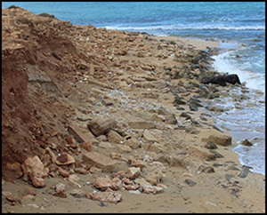
Documentation is based primarily on the assessment of high-resolution satellite imagery for site identification, condition assessment and landscape characterisation, supplemented by marine geophysical data, extant grey and peer-reviewed literature and in situ visits where and when available (Figure 2). Recording these observations enables the development of coastal vulnerability models, which in turn assist local heritage professionals to formulate and prioritise management strategies (e.g. monitoring, field assessment) (Figure 3).

Figure 2. Wave and storm impacts resulting in coastal erosion and damage to buildings of the Classical city of Tocra, Libya (photograph and assessment by Saleh Alaurfi).

Figure 3. Basic first pass coastal vulnerability index model produced for the Jordanian part of Gulf of Aqaba, incorporating data on natural processes and features (wind fetch, elevation, slope and coastal geomorphology) (produced by Kieran Westley on ArcGIS).

Additional examination relies on comparative diachronic analysis of spatial datasets to map shoreline change and quantify erosion and accretion rates. This is further complemented by the documentation of human impacts including conflict, land reclamation, shoreline modification (Figures 4–5), urban expansion and agricultural intensification. These observations will enable researchers and heritage practitioners to identify maritime sites, and rapidly and consistently record characteristics that are necessary to develop interdisciplinary and more holistic narratives surrounding the maritime landscape.

Figure 4. Aerial photograph and satellite imagery analysis in Mokha, Yemen, a key location for international coffee trade between the sixteenth and eighteenth centuries AD (produced by Harmen Otto Huigens on ArcGIS).

Figure 5. Satellite image assessment of al-Bateen shipyard in 2007 (top) and 2019 (bottom). Al-Bateen has undergone major transformation (landfill, dredging and building development) since 2007, with the construction of a modern marina and luxury buildings that gradually displaced shipyards and shipping communities (produced by Rodrigo Ortiz-Vazquez on ArcGIS).

Work in progress

To date, recording has focused on the coastal zones of Tunisia, Libya, Egypt, Lebanon, Syria, Sudan, Yemen, Oman, the UAE, Bahrain and Kuwait. The MarEA project is collaborating with EAMENA to incorporate new maritime-specific terminologies, along with expanding documentation to include geoarchaeological and palaeoenvironmental information. This allows for more accurate identification and assessment of maritime sites and improved contextualisation of their topographic and (palaeo)environmental setting.

The MarEA project is also working on developing heritage-management tools suited to the needs of local practitioners and professionals, such as coastal vulnerability indices, a regional coastal and maritime heritage guide to expand capacity in underwater cultural heritage for archaeological practice in the region.

Preliminary findings indicate that natural coastal processes present the greatest threat to maritime archaeological sites, while recent intensive development is also placing considerable stress on coastal sites and cultural landscapes.

Acknowledgements

We would like to thank the EAMENA team (Oxford, Durham and Leicester Universities) for their collaboration, and we also acknowledge support from antiquities departments, archaeologists and scholars from the Middle East and North Africa region.

Funding statement

We are grateful to Arcadia, a charitable fund of Lisbet Rausing and Peter Baldwin, for generously funding our project.

References

Andreou, G.M. 2018. Monitoring the impact of coastal erosion on archaeological sites: the Cyprus Ancient Shoreline Project. Antiquity Project Gallery 92(361). https://doi.org/10.15184/aqy.2018.1Google Scholar
Bailey, G. et al. 2012. DISPERSE: dynamic landscapes, coastal environments and human dispersals. Antiquity Project Gallery 86(334). Available at: http://www.antiquity.ac.uk/projgall/bailey334 (accessed 8 September 2020).Google Scholar
Benjamin, J. et al. 2017. Late Quaternary sea-level changes and early human societies in the Central and Eastern Mediterranean Basin: an interdisciplinary review. Quaternary International 449: 2957. https://doi.org/10.1016/j.quaint.2017.06.025CrossRefGoogle Scholar
Blue, L. & Breen, C.. 2019. Maritime archaeology and capacity development in the global south. Journal of Maritime Archaeology 14: 321–32. https://doi.org/10.1007/s11457-019-09244-xCrossRefGoogle Scholar
Casana, J. & Laugier, E. Jakoby. 2017. Satellite imagery-based monitoring of archaeological site damage in the Syrian civil war. PLoS ONE 12: e0188589. https://doi.org/10.1371/journal.pone.0188589CrossRefGoogle ScholarPubMed
Castrianni, L., di Giacomo, G., Ditaranto, I. & Scardozzi, G.. 2010. High resolution satellite ortho-images for archaeological research: different methods and experiences in the Near and Middle East. Advances in Geosciences 24: 97110. https://doi.org/10.5194/adgeo-24-97-2010CrossRefGoogle Scholar
Danti, M., Branting, S. & Penacho, S.. 2017. The American Schools of Oriental Research cultural heritage initiatives: monitoring cultural heritage in Syria and northern Iraq by geospatial imagery. Geosciences 7: 95. https://doi.org/10.3390/geosciences7040095CrossRefGoogle Scholar
Fatoric, S. & Seekamp, E.. 2017. Are cultural heritage and resources threatened by climate change? A systematic literature review. Climatic Change 142: 227–54. https://doi.org/10.1007/s10584-017-1929-9CrossRefGoogle Scholar
Hritz, C. 2014. Contributions of GIS and satellite-based remote sensing to landscape archaeology in the Middle East. Journal of Archaeological Research 22: 229–76. https://doi.org/10.1007/s10814-013-9072-2CrossRefGoogle Scholar
Knappett, C. 2011. An archaeology of interaction: networks perspectives on material culture and society. Oxford: Oxford University Press. https://doi.org/10.1093/acprof:osobl/9780199215454.001.0001CrossRefGoogle Scholar
Leidwanger, J. & Knappett, C. (ed.). 2018. Maritime networks in the ancient Mediterranean world. Cambridge: Cambridge University Press. https://doi.org/10.1017/9781108555685CrossRefGoogle Scholar
Pourkerman, M. et al. 2018. Tracking shoreline erosion of ‘at risk’ coastal archaeology: the example of ancient Siraf (Iran, Persian Gulf). Applied Geography 101: 4555. https://doi.org/10.1016/j.apgeog.2018.10.008CrossRefGoogle Scholar
Rayne, L., Bradbury, J., Mattingly, D., Philip, G., Bewley, R. & Wilson, A.. 2017. From above and on the ground: geospatial methods for recording endangered archaeology in the Middle East and North Africa. Geosciences 7: 100. https://doi.org/10.3390/geosciences7040100CrossRefGoogle Scholar
El Safadi, C. & Sturt, F.. 2019. The warped sea of sailing: maritime topographies of space and time for the Bronze Age Eastern Mediterranean. Journal of Archaeological Science 103: 115. https://doi.org/10.1016/j.jas.2019.01.001CrossRefGoogle Scholar
Sturt, F., Flemming, N.C., Carabias, D., Jöns, H. & Adams, J.. 2018. The next frontiers in research on submerged prehistoric sites and landscapes on the continental shelf. Proceedings of the Geologists' Association 129: 654–83. https://doi.org/10.1016/j.pgeola.2018.04.008CrossRefGoogle Scholar
Van de Noort, R. 2013. Climate change archaeology: building resilience from research in the world's coastal wetlands. Oxford: Oxford University Press. https://doi.org/10.1093/acprof:osobl/9780199699551.001.0001CrossRefGoogle Scholar
Westley, K., Carayon, N., Breen, C. & Blue, L.. 2018. Benchmarking the maritime cultural heritage of Syria. Report prepared for the Honor Frost Foundation. Available at: https://honorfrostfoundation.org/2019/08/20/benchmarking-the-maritime-cultural-heritage-of-syria (accessed 8 September 2020).Google Scholar
Zerbini, A. 2018. Developing a heritage database for the Middle East and North Africa. Journal of Field Archaeology 43: 918. https://doi.org/10.1080/00934690.2018.1514722CrossRefGoogle Scholar
Figure 0

Figure 1. Coverage of the MarEA project (produced by Crystal el Safadi on ArcGIS using ESRI DigitalGlobe 2019).

Figure 1

Figure 2. Wave and storm impacts resulting in coastal erosion and damage to buildings of the Classical city of Tocra, Libya (photograph and assessment by Saleh Alaurfi).

Figure 2

Figure 3. Basic first pass coastal vulnerability index model produced for the Jordanian part of Gulf of Aqaba, incorporating data on natural processes and features (wind fetch, elevation, slope and coastal geomorphology) (produced by Kieran Westley on ArcGIS).

Figure 3

Figure 4. Aerial photograph and satellite imagery analysis in Mokha, Yemen, a key location for international coffee trade between the sixteenth and eighteenth centuries AD (produced by Harmen Otto Huigens on ArcGIS).

Figure 4

Figure 5. Satellite image assessment of al-Bateen shipyard in 2007 (top) and 2019 (bottom). Al-Bateen has undergone major transformation (landfill, dredging and building development) since 2007, with the construction of a modern marina and luxury buildings that gradually displaced shipyards and shipping communities (produced by Rodrigo Ortiz-Vazquez on ArcGIS).