


Introduction
The study of ancient and historical salt production has been a major theme for archaeologists of many world regions (e.g. Weller Reference Weller2002; McKillop Reference McKillop2005, Reference McKillop2019; Li & von Falkenhausen Reference Li and von Falkenhausen2010; Flad Reference Flad2011; McKillop et al. Reference McKillop2019; Sherlock Reference Sherlock2021). Questions remain, however, regarding the scale and organisation of production, particularly for the supply of large populations, such as the Classic Maya (AD 300–900). The ancient Maya used two main methods to produce salt: solar evaporation and boiling brine in containers over fires. Evidence for the former is found on the north coast of the Yucatán, where production may have been controlled by nearby inland cities, with distribution facilitated via coastal trading ports, especially in the Postclassic period (AD 900–1500) (Andrews Reference Andrews1983; Kepecs Reference Kepecs, Smith and Berdan2003). Meanwhile, evidence for the evaporation of brine in pots—in the form of briquetage, or coarse vessels and associated ceramic material—is documented at ‘salt kitchen’ sites along the coasts of Belize and Guatemala (McKillop Reference McKillop2019); the boiling of brine was also practised near inland salt springs (Williams Reference Williams2021). In this article, we report on the discovery of a Late Classic-period residential building and three associated salt kitchens that supported the surplus household production of salt at Ta'ab Nuk Na, the largest of the Paynes Creek Salt Works in Belize (Figure 1).

Figure 1. Map showing location of Paynes Creek National Park in southern Belize (inset shows location within the Maya region) (map by M.L. Eggart, based on 1:50 000 Belize topographic map #39; Overseas Surveys 1976).
The excavation of salt kitchens at several of the Paynes Creek salt works has revealed how they were used for producing salt and storing brine, loose salt and salt cakes. Salt was extracted by boiling brine in ceramic bowls, jars or basins made from local clay and quartz sand, supported above fires by solid clay cylinder supports (McKillop Reference McKillop2002: fig. 3.1). These ceramic vessels were standardised in size, but varied significantly in style, suggesting the production of standard-sized salt cakes by differing work parties—perhaps households—for subsequent transportation to inland marketplaces (McKillop Reference McKillop2002, Reference McKillop2021).
The Paynes Creek Salt Works preserves evidence for 110 discrete underwater sites featuring pole-and-thatch buildings constructed along the shores of a seasonally hyper-saline coastal lagoon (McKillop Reference McKillop2019). Pole-and-thatch structures are common in traditional Maya villages today and were likely equally as common at ancient Maya sites, although the tropical environment (and lack of building foundations) means that they are typically archaeologically invisible (Wauchope Reference Wauchope1938; Haviland Reference Haviland1985). Household archaeology provides information on Maya settlement patterns and buildings (Lohse & Valdez, Jr. Reference Lohse and Valdez2004; Robin Reference Robin2012); pole-and-thatch structures are likely to have been used as domestic residences, salt kitchens, workshops, and for storage.
Some 4042 wooden posts demarcating buildings have been mapped at 70 submerged Paynes Creek sites (McKillop Reference McKillop2019); the portions of these posts that had been dug into the ground were remarkably preserved in the anaerobic mangrove peat. Excavation of some of the many smaller sites around the lagoon has identified high densities of briquetage, comprising 90–98 per cent of the material recovered, indicating that they functioned as kitchens for the large-scale production of salt (McKillop & Sills Reference McKillop and Sills2016, Reference McKillop, Sills, Matthews and Guderjan2017). The two largest sites, Ta'ab Nuk Na and Ek Way Nal, were therefore selected for further investigation in the expectation that one or more of the 10 structures mapped at each site may have functioned as a domestic residence for the salt workers or served some functions other than as a salt kitchen.
Mapping wooden architecture and associated artefacts on the sea floor at Ek Way Nal, located in the main channel of the lagoon, revealed a Terminal Classic (AD 800–900) residential structure and associated salt kitchens (see McKillop & Sills Reference McKillop and Sills2021). Here, we report the discovery of a Late Classic (AD 600–800) residential structure and three salt kitchens at Ta'ab Nuk Na, the largest of the Paynes Creek Salt Works sites, dated to the Maya Late Classic, a period during which inland demand for dietary salt was at its greatest. How was coastal production organised to meet that demand?
Organisation of Maya salt production
Several factors are important in delineating the organisation of production, including population concentration (nucleated or dispersed), scale (size); intensity (part-time or full-time); constitution (industrial to kin-based); and context (independent or attached to royal households) (Costin Reference Costin1991). The Paynes Creek Salt Works comprise five nucleated groups of sites within an area of 5km2 (McKillop Reference McKillop2019: fig. 4.7). The discovery of residential structures at both Ta'ab Nuk Na and Ek Way Nal suggests that labour was kin-based, paralleling evidence for Classic Maya household production elsewhere (Sheets et al. Reference Sheets2015). Production was based on household surplus, independent of oversight by royal courts, practised full-time during the dry season, and possibly year-round—as at the modern salt works at Sacapulas, Guatemala (Reina & Monaghan Reference Reina and Monaghan1981).
Coastal Maya salt workers needed to produce surplus salt beyond that required by their own families or community in order to supply this biological necessity to growing Classic-period populations at inland cities, towns and villages. The temporal and spatial shift in production from Ta'ab Nuk Na (Late Classic) to Ek Way Nal (Terminal Classic) raises questions regarding the amount of salt produced by the Paynes Creek Salt Works at any given time. Even with as few as 10 salt kitchens across the 70 mapped sites in operation at any one time, however, the overall level of production would have been high, especially if production was full-time during the four-month dry season or practised year-round (McKillop & Aoyama Reference McKillop and Aoyama2018; McKillop Reference McKillop2019).
Using ethnographic analogy with late twentieth-century production at the Sacapulas salt works, it is possible to estimate the amount of salt produced—either loose salt or fire-hardened salt cakes—at the Paynes Creek Salt Works. At Sacapulas, each family had a kitchen (6 × 8m) dedicated to producing salt by boiling brine from a salt spring; the resulting salt was then traded at marketplaces in the surrounding region (Reina & Monaghan Reference Reina and Monaghan1981). The salinity of the brine from the spring was first concentrated by pouring it over salty soil in a raised container and collecting the enriched brine in jars positioned below. These jars were then moved to salt kitchens, which were distributed in a line near the spring; in addition, each family had a domestic residence located farther away from the spring. Shaping brine-boiling bowls over a mould and baking them in the sun took place outside the residences, but all other aspects of salt production were focused on the salt kitchens. The centre of each kitchen had an elevated platform, allowing the brine to be boiled, using approximately two dozen bowls at a time raised over a fire. The Sacapulas kitchens also featured stacks of firewood, jars of brine or loose salt, salt cakes and neatly stored, broken clay bowls; the latter were periodically dumped outside along the walls of the kitchen. Although most salt was produced during the dry season, salty soil was stored inside, beside the walls and on the floor (thus raising the floor level) in order to allow further salt to be produced, as needed, in the rainy season.
One family studied at Sacapulas produced 113.4kg of salt in two days (Reina & Monaghan Reference Reina and Monaghan1981). Working six days a week, the family could make 340kg, or 5443kg of salt in the four-month dry season. The Sacapulas salt works had 50 kitchens in operation simultaneously during the twentieth century. Applying these figures to the Paynes Creek Salt Works, assuming 10 kitchens were in simultaneous use, salt yields would have been 3400kg per week, or 54 432kg during the four-month dry season (McKillop & Aoyama Reference McKillop and Aoyama2018; McKillop Reference McKillop2019, Reference McKillop2021). Estimating consumption of 6g of salt per person per day (or 2.3kg annually) (Adshead Reference Adshead1992: 191), 10 kitchens could have provided enough dietary salt for 24 000 people. More salt kitchens, however, may have been in use at any one time. Most of the Paynes Creek Salt Works sites have been radiocarbon dated to the Late to Terminal Classic periods (McKillop Reference McKillop2019: fig. 6.18), but whether they were all in contemporaneous use is unknown. If all 110 localities of the Paynes Creek complex were active at the same time, and especially if worked full-time, the scale of production would have been substantial. If only one or a few localities were active at a time, or sites were worked seasonally or part-time, the scale, intensity and nature of production would obviously have been lower.
Ta'ab Nuk Na: discovery, sea-floor survey and mapping
Systematic survey of Ta'ab Nuk Na was conducted using research flotation devices to float back and forth over the submerged site without damaging the artefacts and wood embedded in the sea floor. Temporally diagnostic and distinctive pottery, along with all chert and obsidian, and other material, such as ground stone and wooden posts, were flagged for mapping. Among the resulting forest of coloured and labelled flags, the spatial patterning of artefacts and outlines of buildings are not initially apparent (Figure 2). Therefore, each flagged artefact and wooden post was mapped using a total station position at a fixed, concrete datum (Figure 3). The data were then downloaded to a laptop and transferred to the project GIS in order to observe spatial patterns. The distribution of mapped wooden posts reveals 10 wooden buildings and adjacent plazas or yards. The buildings at the northern end of the site are more clearly defined than those at the southern end, closer to the shore, where mangrove has encroached over them. Plotting the posts by diameter reveals large supporting and corner posts and smaller, non-load-bearing elements (Figure 4).

Figure 2. Southern part of Ta'ab Nuk Na from the water, looking south towards the mangrove shoreline, with flags marking the locations of hardwood and palmetto palm posts in the sea floor at the underwater site (photograph by H. McKillop).
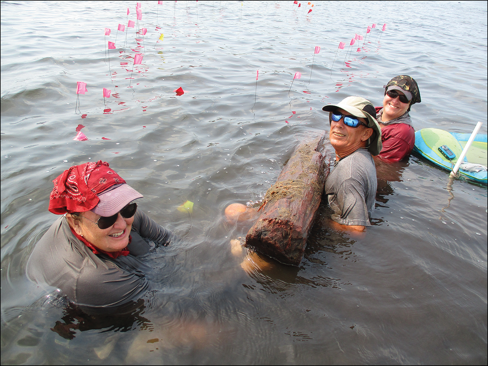
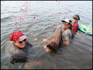
Figure 3. Large Nunavut post from the western periphery of Ta'ab Nuk Na (photograph by C. Foster, Louisiana State University).
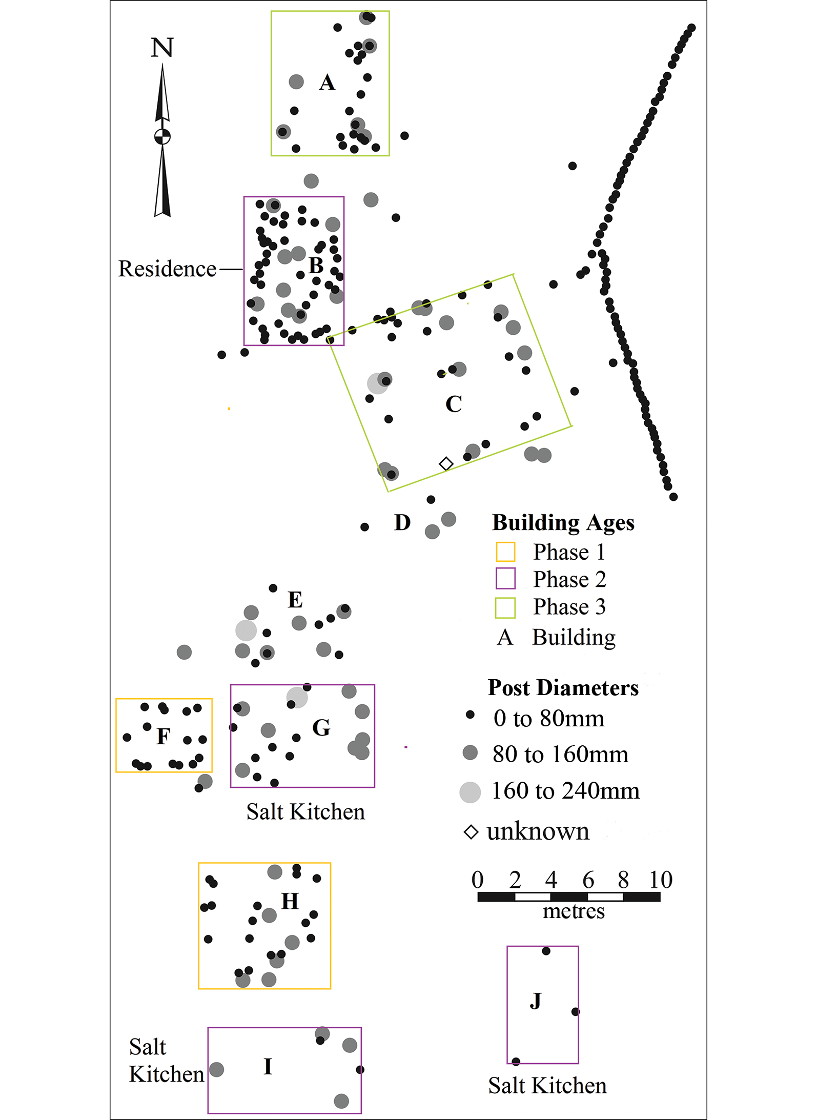
Figure 4. Map showing size ranges of wooden posts, with outlines of buildings assigned to Phase 1 (Buildings F and H), Phase 2 (Buildings B, G, I and J), and Phase 3 (buildings A and C) (map by H. McKillop from total station map by H. McKillop).
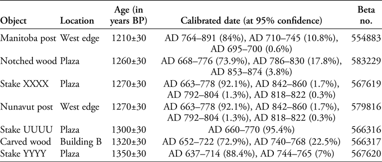
Dating building construction
Radiocarbon dates on samples from the wooden posts indicate three construction phases (Figure 5 & Table 1). The earliest (Phase 1) includes Buildings F and H, built sometime from the end of the Early Classic (AD 300–600) to the first part of the Late Classic (AD 600–800). The site of Ek Way Nal was not in use at this time (McKillop & Sills Reference McKillop and Sills2021: fig. 7) (Figure 5).

Figure 5. Sequence of building construction for Ta'ab Nuk Na and Ek Way Nal, based on radiocarbon-dated wooden posts. Buildings are indicated by letter. Dated post (for Ta'ab Nuk Na) indicated by number. * = rosewood handle (figure by H. McKillop).
Table 1. Radiocarbon dates for wooden posts in chronological order from Ta'ab Nuk Na (at 95% confidence), from Beta Analytic, using the high-probability density range method (Bronk Ramsey Reference Bronk Ramsey2009) and the IntCal20 database (Reimer et al. Reference Reimer2020).

The main phase of construction at Ta'ab Nuk Na took place in the Late Classic, sometime between AD 650 and 750/800 (Phase 2). Four buildings were constructed at this time, including the residential structure (Building B) and three salt kitchens (Buildings G, I and J). This phase of activity coincided with the initial construction of Buildings B and G—both used for salt making—at Ek Way Nal, in the early part of the Late Classic, between AD 650 and 700.
Finally, Buildings A and C at Ta'ab Nuk Na were built during Phase 3, between the end of the Late Classic and the end of the Terminal Classic (AD 800–900). These two buildings have provided limited evidence for salt production. This final phase at Ta'ab Nuk Na corresponds to the peak of salt production at Ek Way Nal during the end of the Late Classic through to the Terminal Classic. Post-dating activity at Ta'ab Nuk Na, Building I at Ek Way Nal represents the final phase of construction at the latter site, dated to the Early Postclassic, between AD 900 and 1000.
Temporal indicators from non-briquetage pottery
Most of the ceramic material from Ta'ab Nuk Na is briquetage, which is not temporally diagnostic. Other pottery, however, is consistent with the Late to Terminal Classic radiocarbon dates on wooden building posts (Figures 6 & 7). Non-briquetage pottery includes Belize Red throughout during all three phases (Figures 6 & 7a). Belize Red is a serving ware imported from the upper Belize Valley and dates to the Late and Terminal Classic periods at Caracol and elsewhere (Chase & Chase Reference Chase and Chase2012). Some modal traits, such as gouge-incised scallop or diagonal lines on the vessel exterior, are not evident in the Ta'ab Nuk Na sample, but are present at other Paynes Creek sites, including Ek Way Nal (McKillop Reference McKillop2002: 86–90, figs 3.35–3.37; McKillop & Sills Reference McKillop and Sills2021). The presence of Belize Red at Ta'ab Nuk Na before the Terminal Classic (AD 800–900), in contrast to its presence after AD 800 at the inland site of Lubaantun (Hammond Reference Hammond1975), suggests that the dates for this type of pottery may be earlier at Lubaantun as well. Warrie Red jars with distinctive stamped decorations on the vessel shoulder (Figure 7b–c) and orange-slipped bowls with incisions (Figure 7d–f) are found in Phases 1 and 2 at Ta'ab Nuk Na. Unit-stamping (impressed geometric or animal designs repeated on the shoulder of the vessel exterior) is rare at Ta'ab Nuk Na compared with other lagoon sites (McKillop Reference McKillop2019: 164–69). At Ek Way Nal, for example, Warrie Red unit-stamped jars are absent in the early part of the Late Classic, but common at the end of the Late Classic and throughout the Terminal Classic. Warrie Red resembles unit-stamped Pantano Impressed pottery at Lubaantun and is also found at other sites (Hammond Reference Hammond1975; Sabloff Reference Sabloff1975; McKillop Reference McKillop2002: 77–86, figs 3.29–3.30).

Figure 6. Map of posts and non-Punta Ycacos pottery, with artefact catalogue numbers and description. Buildings F and H are Phase 1; Buildings B (residence), G, I and J (salt kitchens) are Phase 2; Buildings A and C are Phase 3; Buildings D and E are of unknown age (map by H. McKillop from total station map by H. McKillop).
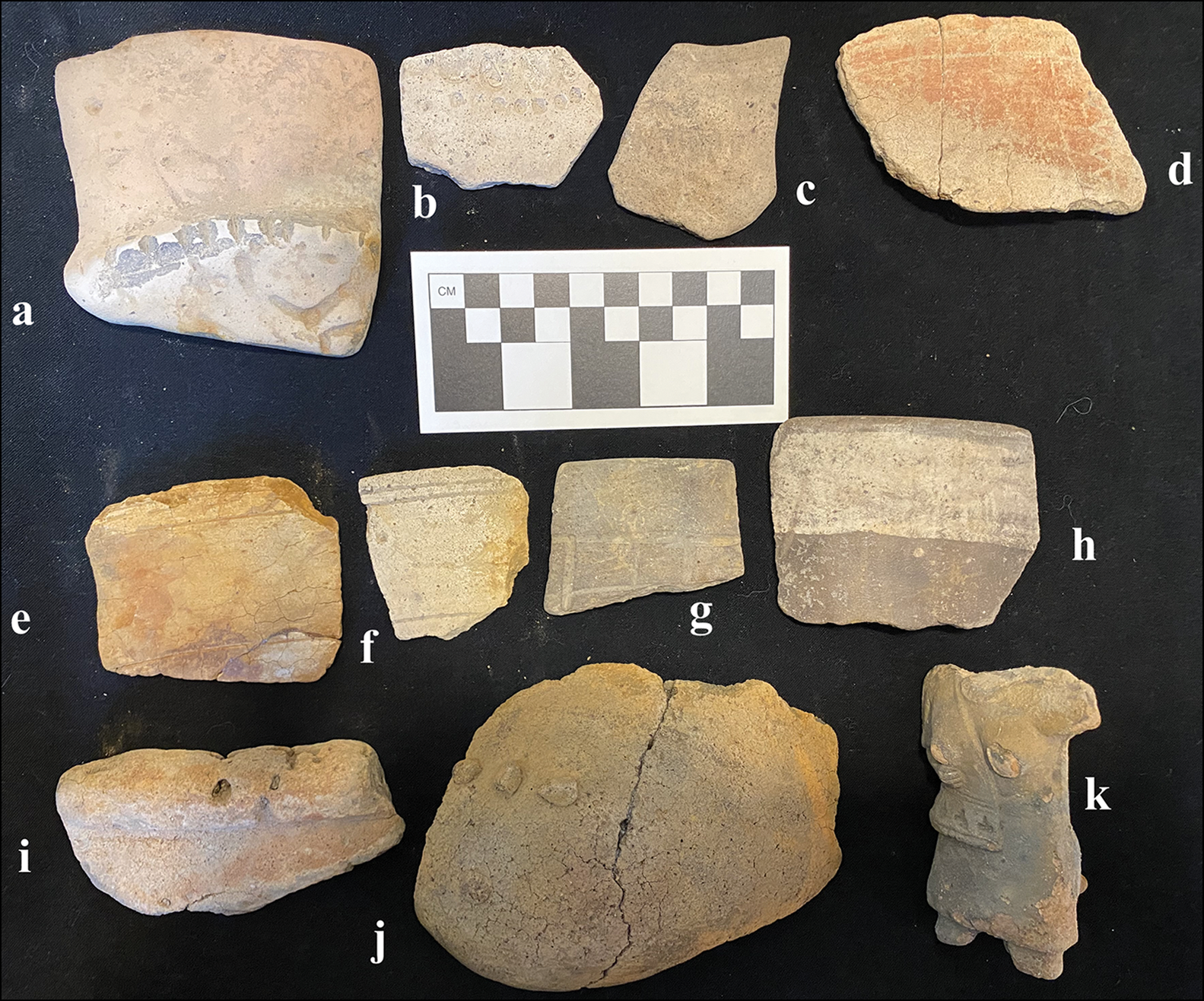
Figure 7. Selected Late to Terminal Classic pottery (see Figure 6 for positions in relation to buildings): a) Belize Red bowl (BBBBB1), with notched basal angle; b) Warrie Red jar (MMMM5), with ‘S’ stamp; c) Warrie Red jar (JJJJ), with thumbnail impressions; d) orange-slipped bowl (MMMM2), with exterior zig-zag and line incisions; e) orange-slipped rim (XXXX1), with dashed incisions; f) incised bowl (OOOOO3); g) slipped vase rim (GGGG), with incised glyphs in blocks; h) vase rim (CCCC1), with painted band below the rim; i) bolstered rim of red-slipped bowl (L); j) shoe pot (jar with one wall expanded in size; LLLLL2); k) ocarina (figurine whistle of woman, with sound chamber behind; MMMMM) (photograph by H. McKillop).
Late Classic pottery includes a vase rim sherd with pseudoglyphs (Figures 6 & 7g) that resembles a partial vase that was found on survey before the site was mapped (McKillop Reference McKillop2019: fig. 6.3a), and a vase sherd with a painted rim band (Figure 7h). Bowls with exterior bolstered rims are assigned to Phases 2 and 3, based on their discovery in dated buildings A, B and I (Figure 7i). A partial shoe-pot (with one side expanded in a shoe form; Figures 6 & 7j) from Building B resembles an example from Pork and Doughboy Point (Hammond Reference Hammond1975: fig. 105b). A red-slipped tobacco pot was recovered from near Building J (McKillop Reference McKillop2019: fig 6.3b) (Figure 6). Both shoe-pots and tobacco pots are found at other Late Classic sites. Phase 2 includes the only Lubaantun-style ocarina (figurine whistle), which was not made at Ta'ab Nuk Na and may have been made at Lubaantun (Figure 7k). Lubaantun-style ocarinas are present at Ek Way Nal during the site's initial construction phase in the early part of the Late Classic but are subsequently absent (McKillop & Sills Reference McKillop and Sills2021: figs 16–17).
Building B
Building B is interpreted as a residential structure for the salt workers during Phase 2, due to the absence of briquetage and the diversity of other ceramics and stone tools used for domestic tasks, such as cooking, storage, serving and consumption. Alongside Warrie Red water jars, Building B also featured Belize Red serving bowls, vases, a shoe-pot, and an open bowl with an exterior bolstered rim (Figure 6). A ceramic spindle whorl (perforated potsherd disc) suggests the spinning of cotton for fishing nets or clothing (artefact WW), while the leg of a stone metate (a type of quern) indicates the grinding of maize (artefact S) (Figure 8). A variety of chert tools was found on the sea floor at Building B (Figure 8). Most of the chert from Building B and elsewhere at Ta'ab Nuk Na resembles chert from Colha in northern Belize, indicating that the Ta'ab Nuk Na Maya were able to trade beyond the southern Belize region for high-quality chert. Use-wear analysis of 20 chert artefacts from Ek Way Nal and other sites in the lagoon system indicates that most were used for processing fish or meat, with some used for cutting or whittling wood (McKillop & Aoyama Reference McKillop and Aoyama2018; McKillop & Sills Reference McKillop and Sills2021). The Ta'ab Nuk Na chert tools are therefore expected to be multi-purpose, including woodworking. In addition to wooden building posts, wooden objects recovered include a small paddle from west of Building B (McKillop Reference McKillop2019: fig. 6.14; Figure 8) and a carved object in Building B (Table 2). Too small for use with a canoe, the wooden paddle may have been used to stir large pots of food or salt.
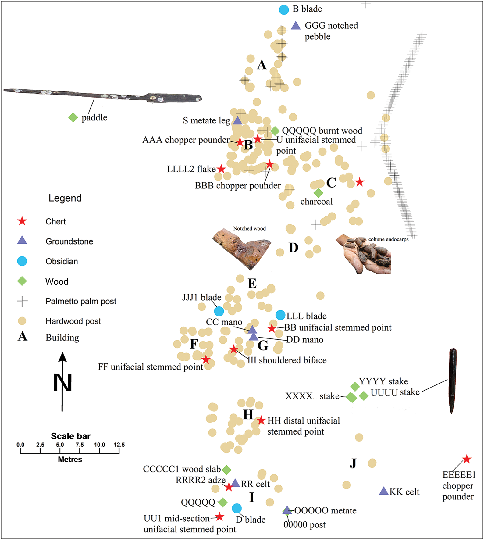
Figure 8. Map showing wooden posts, as well as chert, ground stone, obsidian, and wooden artefacts, with artefact catalogue numbers and description. Wooden paddle = 0.9m long; UUUU wood stake = 0.2m long (map by H. McKillop from total station map by H. McKillop).
Table 2. Radiocarbon dates for wooden objects from Ta'ab Nuk Na in chronological order (at 95% confidence), from Beta Analytic, using the high-probability density range method (Bronk Ramsey Reference Bronk Ramsey2009) and the IntCal20 database (Reimer et al. Reference Reimer2020). See Figure 9 for images of notched wood and UUUU stake and Figure 3 for Nunavut post.
Buildings G, I and J as salt kitchens
The Maya salt workers lived in Building B and used Buildings G, I and J as salt kitchens. These latter buildings were the focus for brine boiling in Phase 2 (c. AD 650–780). Evidence of salt production consists of briquetage, represented by jars, bowls and basins of the Punta Ycacos Unslipped pottery type (McKillop Reference McKillop2002: 54–72) (Figure 9a–c & e). In contrast to its absence in Building B, briquetage is abundant in Buildings G, I and J (Figure 10). Solid clay cylinder vessel-supports include examples with flat bases or sockets, where the vessel rested at the top of the cylinder support. Also present amongst the salt production equipment are jars for storing brine or loose salt and grinding stones for preparing maize used in salt production.

Figure 9. Punta Ycacos pottery from the sea-floor survey, with artefact catalogue numbers, description and building location: a) 69B, basin; b) basin rim (VVVV) exterior, Building I; b) basin rim (VVVV) exterior, Building I; c) basin rim (VVVV) interior, Building I; d) boat model (TTTT2), with four holes for suspension, Building J; e) Paynes Creek open bowl (LLLL2), interior, Building B; f) funnel (DDDD1) for channelling enriched brine into pot, Building I; g) figurine body (PPPP), Building F (photograph by H. McKillop).

Figure 10. Map of posts and Punta Ycacos pottery, including briquetage, as well as non-salt making objects (composite burners, candeleros, handles, figurine, canoe model and incised sherd), with artefact catalogue numbers and descriptions (map by H. McKillop from total station map by H. McKillop).
Punta Ycacos Unslipped pottery (Phase 2) from Buildings A, G, I and J also includes non-briquetage artefacts made from the same clay and quartz sand temper as the brine-boiling artefacts. Similar artefacts were recovered from Building F, which lacks evidence for brine boiling (Figures 9–10). Non-briquetage Punta Ycacos artefacts include composite burner stands (Ball & Taschek Reference Ball and Taschek2007), candeleros (small incense burners), a model canoe with four holes for suspension (Figure 9d), a figurine (Figure 9g), handles from burners (Figure 10), and a sherd with checkerboard incising (artefact OOO; Figure 10). Composite burner-stands were used for household cooking and have been found in domestic contexts in the upper Belize Valley and at Caracol (Chase & Chase Reference Chase, Chase, Demarest, Rice and Rice2004; Ball & Taschek Reference Ball and Taschek2007). The figurine and canoe model may have been toys. Water jars were needed for storing enriched brine before it was boiled and for storing the resultant loose salt, as at Sacapulas (Reina & Monaghan Reference Reina and Monaghan1981). Three types of non-local water jars at Ta'ab Nuk Na are Warrie Red, Mangrove Unslipped and Paynes Creek Unslipped (Figure 6).
Although grinding stones indicate the domestic preparation of maize or other foods, manos and metates (grinding stones) also are used in the brine-boiling process in the Maya highlands. At Sacapulas, if a ball of maize meal floated in the enriched brine, it was considered sufficiently salty for boiling (Reina & Monaghan Reference Reina and Monaghan1981). The brine-boiling bowls in the salt kitchens were coated with maize meal before brine was added, in order to seal the vessel surface. At Ta'ab Nuk Na, evidence for maize grinding has been found in Building B and in the salt kitchens (Buildings G and I).
Activities at Ta'ab Nuk Na
Alongside the residential structure (Building B) and the focus on brine boiling in Buildings G, I and J, other activities at the site probably included the enriching of brine before it was boiled, the preparation of fishing gear, spinning of cotton, food consumption, crafting of clay objects, cutting and whittling of wood, cleaning and cutting of fish/meat, and the drying and salting of fish/meat. Some of these activities took place within Building B, and others in the open. A clay funnel (DDDD1; Figures 9f & 10) was possibly used in the brine-enrichment process, as at the Eleanor Betty site, where a funnel was found under a wooden canoe that had been repurposed as a container for salty soil (McKillop et al. Reference McKillop, Sills and Cellucci2014). Fishing is attested by the recovery of a notched pebble (artefact GGG) that was probably used as a fishing weight (McKillop Reference McKillop2019: fig. 6.6; Figure 8).
Some salt was probably used for preserving fish, as indicated by use-wear analysis of chert tools from other lagoon sites (McKillop & Aoyama Reference McKillop and Aoyama2018). The absence of fish or other bones is unsurprising, given the acidic red mangrove peat, which dissolves limestone and dolomite temper in pottery. Three wooden stakes buried in deep silt north of Building J may have held lines from a drying rack or other apparatus used to preserve fish or meat (Figure 8)—an activity reported from other coastal sites in Belize (Graham Reference Graham1994; Masson Reference Masson and Emery2004: 114). Radiocarbon dating of the stakes indicates they are contemporaneous with Buildings B, G, I and J (Table 2). A wooden slab (artefact CCCCC1) between Buildings H and I (Figure 8) may be part of a box for salting fish. The notched wood in the plaza (Figure 8) and the carved wooden object in Building B also date to Phase 2 (Table 2).
Food consumption is attested by the abundance of uncharred endocarps from native cohune palms (Attalea cohune), which are abundant on the nearby high ground to the west of the Deep River (Wright et al. Reference Wright, Romney, Arbuckle and Vial1959), as well as mano and metate fragments from Buildings B, G and I. Cohune endocarps were common on the sea floor, in particular to the south of Building C (Figure 8). Cohune, as well as coyol palm (Aculeata mexicana), was a common food recovered from midden deposits at Wild Cane Cay and other nearby coastal communities (McKillop Reference McKillop1994).
Woodworking is suggested by wooden objects, sharpened ends of building posts, and the diversity of chert stone tools found in all buildings except A and J (Figure 8). A long pole (Manitoba post) aligned with a line of palmetto palm posts on the west side of the site dates to Phase 3, and is contemporaneous with Building A (Table 2). A short, heavy beam (Nunavut post; see Figure 3 & Table 2) dates to Phase 2, as do the three wooden stakes north of Building J (Figure 8).
Discussion
Based on radiocarbon dates from building posts at Ta'ab Nuk Na, construction at the site began with Buildings F and H, sometime between the end of the Early Classic and the first part of the Late Classic. Neither building produced evidence of salt production from the sea floor. Four buildings were then constructed during the Late Classic, including a large residential structure (Building B) and three salt kitchens (Buildings G, I and J). The timing of this is significant, placing salt production at Ta'ab Nuk Na during the most developed ancient Maya period, when inland dietary salt was most in demand. The dates refine previous radiocarbon dating of 40 other sites in the lagoon, which indicate salt production during the Late and Terminal Classic (McKillop Reference McKillop2019: tab. 6.2 & fig. 6.18). In contrast, most evidence for construction and salt production at Ek Way Nal dates to the end of the Late Classic through to the Terminal Classic (McKillop & Sills Reference McKillop and Sills2021).
Ta'ab Nuk Na is the largest of the submerged sites, with slightly more than 600 mapped posts. Long lines of palmetto palm posts on the east and west sides defined the site's boundaries, shored up the edges of the land and defined open areas for various activities. The clay funnel outside Building I suggests that brine enrichment took place in this area. The wooden slab between Buildings I and H may be part of a wooden box for salting fish. The wooden stakes in the sea floor to the north of Building J may have held a wooden rack for drying salted fish.
The temporal difference between Ta'ab Nuk Na and Ek Way Nal may reflect a shift in production from one area of the lagoon system to another. Ta'ab Nuk Na is the largest site in the West Point area, whereas Ek Way Nal is the largest site in the Main Channel. The dating of individual buildings at Ta'ab Nuk Na and Ek Way Nal indicates that both were multi-component sites and underscores the value of radiocarbon dating individual buildings at other salt works.
Conclusions
Ten wooden buildings and associated artefacts mapped on the sea floor at Ta'ab Nuk Na provide new information on the organisation of Classic Maya salt production using the brine-boiling method. Radiocarbon dates on building posts provide a three-phase construction sequence spanning the end of the Early Classic through the Late and Terminal Classic periods, with evidence for a residential structure and a peak of salt production during the Late Classic. Building B, constructed during Late Classic Phase 2 (c. AD 650–780), is identified as a residential structure on the basis of a diversity of pottery and stone objects typical of household use at other Maya sites, and an absence of briquetage. These artefacts indicate activities such as catching and processing fish, spinning cotton, and other household tasks, including cooking, grinding maize and woodworking. The discovery of the residential building at Ta'ab Nuk Na supports a view of household production by workers living on site.
Contemporaneous salt kitchens in Phase 2 include Buildings G, I and J, which were used for brine boiling, as indicated by briquetage, but also contained other objects, including an ocarina and a locally made figurine. Other salt-related activities may have included brine enrichment and the preservation of fish.
Salt production by a household at Ta'ab Nuk Na fits well with a Classic Maya economy, where households produced surplus resources or commodities for local exchange, as well as for trade at regional marketplaces (Robin Reference Robin2012; Sheets et al. Reference Sheets2015). Estimates of salt yields based on ethnographic analogy with historic salt production at Sacapulas underscore the large quantities of salt produced by such households (Reina & Monaghan Reference Reina and Monaghan1981). Extrapolating beyond Ta'ab Nuk Na to the greater Paynes Creek Salt Works, more than enough salt was produced across 10 salt kitchens to meet the dietary needs of nearby, inland communities in the Classic period (McKillop & Aoyama Reference McKillop and Aoyama2018; McKillop Reference McKillop2019).
Acknowledgements
The fieldwork was carried out under permits from the Belize Institute of Archaeology, for which we are grateful. We appreciate assistance, both in the field and in the laboratory, of current and former LSU undergraduate and graduate students, particularly Cher Foster, Rachel Watson, Hollie Lincoln, Rianna Bowen, Conner Flynt, Matt Helmer, Amanda Pitcock and Mark Robinson, as well as Orlando Usher, John Young, and our host family, Tanya Russ and John Spang. We appreciate comments on the manuscript from Arlen Chase and Nan Gonlin.
Funding statement
This research was funded by NSF grants 0513398 and 000451189.


 Open access