


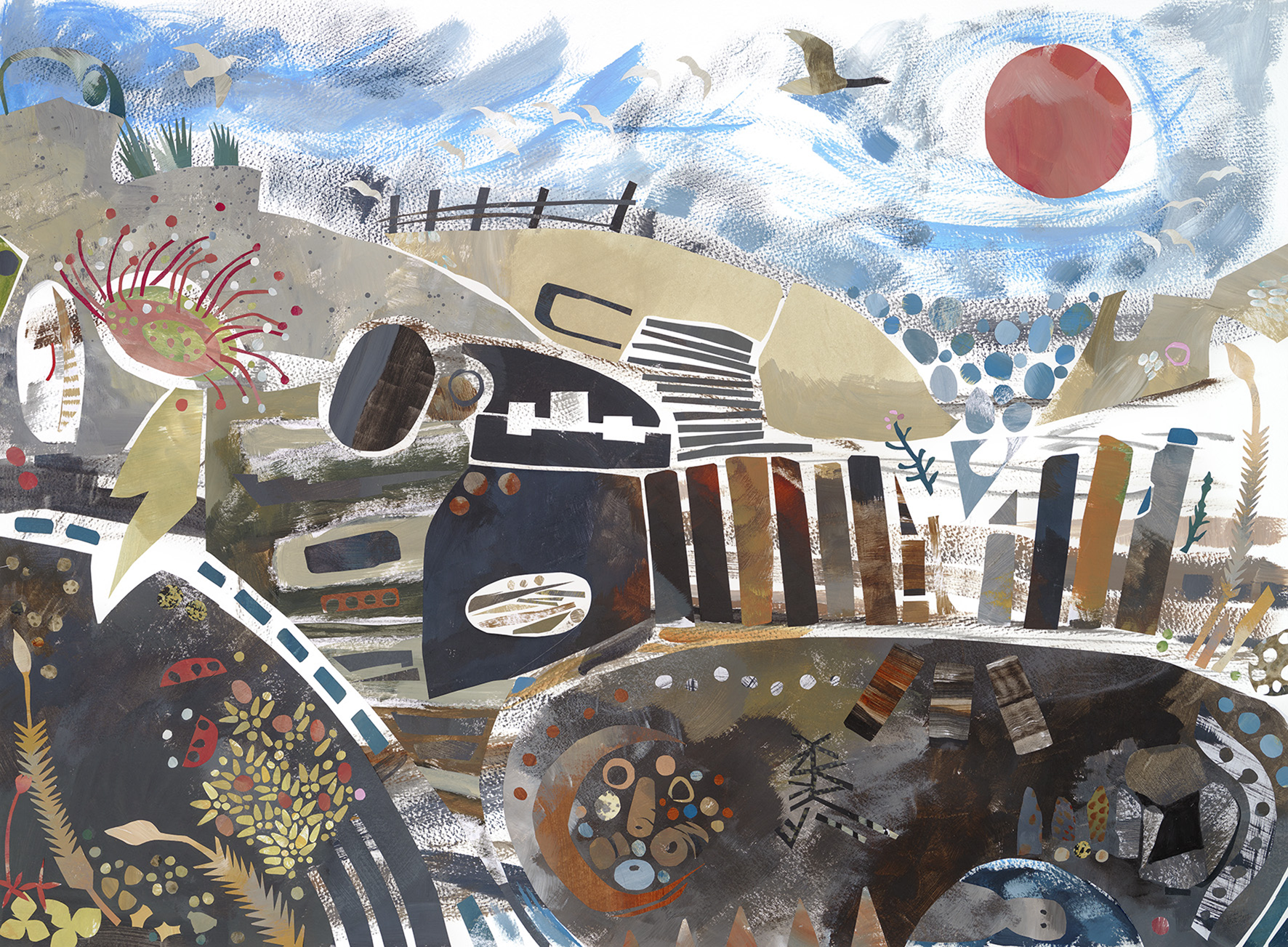
Frontispiece 1. A collage by artist/archaeologist Rose Ferraby, created for a collection of archaeological poetry, Peat (2023), edited by Melanie Giles and published by Guillemot Press. Developing from the ‘Peat Pasts, Presents, Futures project’ at the University of Manchester (funded by UMRI), the collection follows the past, present and future of peatlands and their interwoven stories of ecologies, human lives and changing climates. Image © Rose Ferraby.

Frontispiece 2. Aerial view of excavation in advance of a residential development, south of Salisbury, UK. Five Bronze Age round barrows, from a cemetery of approximately 20 such monuments, have been investigated. The barrows, levelled by centuries of agriculture, survive only as ditches. The photograph shows one circular ditch cut into hill wash on the Nadder valley floor (top) and another cut into the adjacent chalk hillside, on the northern edge of Cranborne Chase (bottom). At the centre of the latter barrow was the inhumation burial of a child, one of ten burials and three un-urned cremations recovered from the site. Other features include hundreds of pits of Neolithic, Bronze and Iron Age date and a possible Saxon sunken-featured building. Photograph © Rosanna Price/Cotswold Archaeology.
The Nebelivka Hypothesis: cities past
![]() Each year, The Antiquity Trust sponsors the Theoretical Archaeology Group (TAG) plenary session. The keynote speaker at Edinburgh TAG 2022 was David Wengrow, who spoke about ‘The Nebelivka Hypothesis (or, cities against the state)’, using the Trypillia mega-sites to question the definition of urbanisation and the position of the modern state as a telos of human political development. Now, the Nebelivka Hypothesis has evolved into an installation at the Venice Biennale. John Chapman and Bisserka Gaydarska, who have worked extensively on the mega-sites including Nebelivka, reflect on their recent visit to La Serenissima:
Each year, The Antiquity Trust sponsors the Theoretical Archaeology Group (TAG) plenary session. The keynote speaker at Edinburgh TAG 2022 was David Wengrow, who spoke about ‘The Nebelivka Hypothesis (or, cities against the state)’, using the Trypillia mega-sites to question the definition of urbanisation and the position of the modern state as a telos of human political development. Now, the Nebelivka Hypothesis has evolved into an installation at the Venice Biennale. John Chapman and Bisserka Gaydarska, who have worked extensively on the mega-sites including Nebelivka, reflect on their recent visit to La Serenissima:
Almost ten years ago Antiquity published the first, and so far only, complete geophysical plan of a Trypillia mega-site—that of Nebelivka, in central Ukraine.Footnote 1 The Anglo-Ukrainian project that has been investigating the world's first low-density egalitarian cities has now reached a new milestone of public recognition through an installation at the 18th Venice Architecture Biennale. The interdisciplinary nature of this biennale, with much anthropology, geography and fine arts alongside architecture, has ensured that the Trypillia mega-sites are in good company, including 16 practices representing African and Diaspora architectural production on show in the Giardini exhibition space and 37 practitioners in the ‘Dangerous Liaisons’ section in the Arsenale. This is a smorgasbord of an exhibition, with visitors free to make their own connections across time and space. In the widely praised Brazilian pavilion focusing on Indigenous production, two quotations help to make sense of the Trypillia presence in Venice: Benin artist, Thierry Oussou (2019) reminds us that “without memory, there is no people”, while Sonia Guajajara (2023) from Brazil's newly formed Ministry of Indigenous Peoples, posits that “The future is ancestral”. Memories and ancestors were central to the Trypillia experience of living in the mega-sites and of how that experience is portrayed in the Venice installation.
The Nebelivka Hypothesis—cities against the state’ has been created by the Forensic Architecture Group at Goldsmiths College, London (Eyal Weizman, Davide Piscitelli and colleagues),Footnote 2 in collaboration with David Wengrow (UCL-Institute of Archaeology), the Kyiv-based Centre for Spatial Technologies and the Anglo-Ukrainian Nebelivka research group. The installation features a 10 × 2m space ‘excavated’ into the gallery's concrete floor to evoke a Trypillia dwelling-house (Figure 1). Video back-projections then fill this ‘house’, telling the story of the discovery of the mega-sites and their geophysical investigation.
The installation shows how the geophysical results relate to the buried remains, how Trypillia farming created new soils, and how the egalitarian plan of the site, based upon neighbourhoods and quarters incorporating people from nearby smaller Trypillia sites, evolved. The key message is that the development and occupation of these cities did not need hierarchy, top-down control or military force, as emphasised in traditional accounts of urban development. This alternative—and timely—narrative is further explored by David Graeber and David Wengrow in The Dawn of Everything.Footnote 3
The videos are complemented by a series of interviews with the present-day inhabitants of Nebelivka and a book summarising the video commentary. As Weizman and Wengrow suggest, this exhibition marks the artistic culmination of the Nebelivka Project. But, in a wider sense, at this time of mortal danger to the Ukrainian state, this installation underlines the scarcely acknowledged contribution of those ancestors who once lived in the area of modern Ukraine to the world's historical evolution in the form of the planet's earliest cities. Readers are warmly invited to visit the 18th Architecture Biennale, which remains open until 26 November 2023. After that date, it is hoped that the video, with accompanying interviews and book, will be available for display in other venues.

Figure 1. The Nebelivka Hypothesis (photograph by Marco Zorzanello, courtesy of La Biennale di Venezia).
Neom: cities future
![]() Over on the other side of the Grand Canal, timed to coincide with the Biennale, a trade exhibition is promoting a self-styled ‘smart’ city under construction in northern Saudi Arabia: Neom. One of the most distinctive elements of this futuristic development is a planned super-skinny linear city (‘The Line’), 200m wide but 170km long, stretching inland from the Red Sea coast. This utopian project promises to correct pretty much every architectural, ecological, social and economic ill that has characterised the previous 6000 years of city-building by, seemingly, offering more of the same. On steroids. And then some. Given the themes of this year's Biennale, including decarbonisation and decolonisation, Neom not only fails to ‘read the room’, it demolishes the room and rebuilds it—bigger, smarter, longer!
Over on the other side of the Grand Canal, timed to coincide with the Biennale, a trade exhibition is promoting a self-styled ‘smart’ city under construction in northern Saudi Arabia: Neom. One of the most distinctive elements of this futuristic development is a planned super-skinny linear city (‘The Line’), 200m wide but 170km long, stretching inland from the Red Sea coast. This utopian project promises to correct pretty much every architectural, ecological, social and economic ill that has characterised the previous 6000 years of city-building by, seemingly, offering more of the same. On steroids. And then some. Given the themes of this year's Biennale, including decarbonisation and decolonisation, Neom not only fails to ‘read the room’, it demolishes the room and rebuilds it—bigger, smarter, longer!
Of course, planned cities are nothing new, from royal capitals to colonies imposed on imperial peripheries. Such foundations have a habit, sooner or later, of disappointing the ideals espoused by their builders. Some, such as Akhenaten's Amarna, fail to outlive their founder. Others, such as Yaśodharapura (Angkor), thrived for several centuries before finding themselves rendered peripheral by wider geopolitical developments. Many remain in occupation today—for humans are quick to form an attachment to place and slow to move on—but how many of these cities now resemble or embody their founders’ visions? Few have not outgrown their limits, been destroyed and rebuilt, or adapted to new realities. Beijing has sprawled far beyond the perfect square city established by the Ming according to the cosmological planning principles of the Kao Gong Ji; and no trace remains of the round city of Baghdad founded by the Abbasid Caliph al-Mansur. In short, even a cursory historical lesson suggests the best-laid architectural plans rarely survive contact with reality unchanged following contact with reality.
But Neom's phantasmagorical vision is not casually ahistorical; it revels in the suggestion of a clean break. One of the initiative's slick promotional videos baldly states: “We can elevate life because we have a blank canvas”.Footnote 4 Like most places claimed as terra nullius, however, this is not a blank or empty landscape. In the same way that the so-called ‘Empty Quarter’ (Rub’ al Khalim) of the southern Arabian peninsula has been settled and exploited for millennia, so has the region around Neom.Footnote 5 The construction of this new city, like any other, will therefore involve the displacement of present-day inhabitants and damage to the environment and archaeological sites. A recent study, for example, has used remote-sensing data to assess the impact of construction work on the archaeology of the region, identifying not simply the potential destruction of sites but also the severing of historical landscapes of movement, such as caravan routes.Footnote 6 The Nebelivka Hypothesis postulates that the genealogy of cities as one of extraction, predation and hierarchy must change if we are to achieve a sustainable and equitable future. The Neom Hypothesis posits the exact opposite. For all its futurism, Neom is stuck in the past, doing more of the same, and attempting to sell us a different outcome.
Borders past and present
![]() By geometrically cutting across the landscape, ‘The Line’ is less like a city and more like a border. This brings us neatly to a debate section in the current issue exploring the archaeology of ancient and modern-day borders, emphasising how contemporary political debate draws upon the former to shape the latter. In the opening article, Emily Hanscam and Brian Buchanan compare contemporary perceptions of Hadrian's Wall in the north of Roman Britain with the modern-day US/Mexico border. They argue that archaeologists need to address more directly the material and imagined continuities of such borders and the socio-political narratives drawn from them in public discourse.
By geometrically cutting across the landscape, ‘The Line’ is less like a city and more like a border. This brings us neatly to a debate section in the current issue exploring the archaeology of ancient and modern-day borders, emphasising how contemporary political debate draws upon the former to shape the latter. In the opening article, Emily Hanscam and Brian Buchanan compare contemporary perceptions of Hadrian's Wall in the north of Roman Britain with the modern-day US/Mexico border. They argue that archaeologists need to address more directly the material and imagined continuities of such borders and the socio-political narratives drawn from them in public discourse.
The call is timely. A recent report, A Walled World: towards a global apartheid, documents that in the year the Berlin Wall fell, 1989, there were just six border walls between nations; by 2018 that figure had increased to 63, with three-quarters of these new borders located in Europe and Asia.Footnote 7 While these increasingly securitised lines represent a new phenomenon in terms of their numbers, the concept of the border is not new. And some of the earliest known examples are found in the same region where they are proliferating today: Western Asia. For example, the title of James Crawford's The Edge of the Plain: how borders make and break our world Footnote 8 is inspired by a territorial dispute between the cities of Lagash and Umma in third-millennium BC Mesopotamia. This multigenerational conflict over a strip of fertile land called Gu'edina, or the ‘Edge of the Plain’, is recorded in several sources, including on an inscribed limestone pillar, currently in the British Museum, that was intended to mark the border and resolve the conflict. The dispute, however, continued, ultimately ending in the destruction of Lagash.Footnote 9 Another case, from only a few centuries later, is the ‘Très Long Mur’, a low stone wall running for more than 200km across the Syrian steppe, probably marking the eastern border of the kingdoms of Hama or Ebla.Footnote 10 The debate piece by Hanscam and Buchanan and the four invited responses look critically at the discourse around the archaeology of such borders and advocate for a more progressive and proactive field that encompasses both past and present. In doing so, they are not alone; a new book on Africa in the Roman Empire, for example, rejects the colonial concepts and terminology of earlier accounts and recasts the Roman ‘frontier’—which included several stretches of stone wall—as a ‘security zone’ for the Mediterranean Empire.Footnote 11 This change in terminology actively reflects that of contemporary geopolitics. Given the EU's attempts to externalise the southern border of Europe by paying African states to intercept migrants before they arrive on the Mediterranean shore, the EU borderlands now reach into sub-Saharan Africa, encompassing a security zone across the same region as that which buffered the Roman Empire. In the post-globalisation age, the resurgence of nationalism, combined with the growing mobility of people seeking to escape war, poverty and climate change, suggests that borders will further proliferate in coming years. Archaeologists have a role to play here, and need to look again at the archaeology of borders and borderlands to contribute to wider understanding of their effects, past and present.
Archaeological futures: Indigenous Archaeology
![]() Periodically, we have invited archaeologists from different parts of the world to take stock of recent developments in specific fields or regions and to consider how the subject might develop. In the latest contribution to our ‘Archaeological Futures’ series, Lindsay Montgomery (University of Toronto) and Tiffany Fryer (University of Michigan) reflect on the reshaping of archaeological research in the Americas through collaborative community-engaged research. Reviewing a growing body of work informed by decolonisation, the authors explore the shifting power dynamics within the discipline and, connecting with our debate feature on borders, the need for a political and socially relevant archaeology. Drawing examples from South, Central and North America, the authors identify the centrality of collaborative work to address topics of importance for Black and Indigenous scholars and descendant communities. While the authors focus on the Americas and some of the specific contexts and research found there, the wider issues and themes they raise resonate globally.
Periodically, we have invited archaeologists from different parts of the world to take stock of recent developments in specific fields or regions and to consider how the subject might develop. In the latest contribution to our ‘Archaeological Futures’ series, Lindsay Montgomery (University of Toronto) and Tiffany Fryer (University of Michigan) reflect on the reshaping of archaeological research in the Americas through collaborative community-engaged research. Reviewing a growing body of work informed by decolonisation, the authors explore the shifting power dynamics within the discipline and, connecting with our debate feature on borders, the need for a political and socially relevant archaeology. Drawing examples from South, Central and North America, the authors identify the centrality of collaborative work to address topics of importance for Black and Indigenous scholars and descendant communities. While the authors focus on the Americas and some of the specific contexts and research found there, the wider issues and themes they raise resonate globally.
Montgomery and Fryer begin with recent events surrounding the management of the Montpelier estate in Virginia which was owned by the fourth US president, James Madison. Like many of the founders of the United States, Madison used enslaved people to work his estate.Footnote 12 During 2022, the Board of Montpelier, which now oversees the site, became embroiled in a public dispute involving co-stewardship with descendant communities and the estate's approach to wider collaborative heritage management practices intended to redress Montpelier's legacy of oppression. The eventual resolution of that dispute coincided with the announcement earlier this year of a $5.8m grant for the construction of a memorial to the enslaved people who lived and worked at Montpelier.Footnote 13 The memorial to the ‘Invisible Founders’ has been funded by the Mellon Foundation as part of its five-year, $250m initiative to “reimagine and rebuild commemorative spaces and transform the way history is told in the United States”.Footnote 14 Over the past five years, many public statues and monuments—of colonialists, slaveowners, Confederates and others—have been removed from public spaces in the US and around the world; the Mellon Foundation initiative represents the next step in reshaping these spaces, moving on from removal to replacement.
This year's Society for American Archaeology (SAA) meeting (29 March–2 April) featured several sessions dealing with collaborative and community-driven archaeology. The conference was held in Portland, Oregon, located in the traditional lands of the Multnomah, Clawwe-wallah and Clackamas Chinookan peoples and Tualatin Kalapuya. In addition to various presentations and round tables, some delegates also visited the Fort Vancouver National Historic Site to hear about recent work underway there to decolonise the presentation of the site. Located across the Columbia River from Portland, Fort Vancouver was a fur-trading post that served as the Pacific headquarters of the Hudson's Bay Company during the early nineteenth century. The original impetus for the preservation and public presentation of the site, which began in 1948, was closely connected with the fort's significance for a Euro-American history of the region—having several hundred inhabitants from Europe and the US East Coast, it was for some decades, the largest non-Native settlement in the Pacific Northwest. But Fort Vancouver was also a cosmopolitan place; adjacent to the fort was a settlement known as Kanaka Village, named for the many kanaka, or Pacific Island workers, especially from Hawai‘i, who lived and worked at the fort, as well as local Indigenous traders and families. Increasingly, the archaeological investigation and heritage presentation of sites such as Fort Vancouver are being re-orientated to ensure the fuller acknowledgement of the roles of all those who were present.
Fort Vancouver was only one of a whole network of similar trading posts across the Pacific Northwest and, after the SAA meeting, I headed towards the coast to investigate some other locations of historical encounters. On an overlook near the mouth of the Columbia River stands a 38m-high column, erected in 1926, narrating the history of the city of Astoria (Figure 2). Bar a brief mention of the time “Before the white men came”, the Astoria Column offers a history that begins with European contact and is driven by colonial achievement. It reports Captain Robert Grey's arrival at the mouth of the Columbia in 1792, the overland arrival of the Lewis and Clark expedition in 1805, the foundation of Fort Astoria and the development of the fur trade, the arrival of the pioneers and so on. The Indigenous peoples of the region appear throughout the spiralling narrative, but there is no doubt that ‘progress’ was the work of the Euro-Americans. The Astoria Column was inspired by and modelled on Trajan's Column in Rome—which narrates the eponymous emperor's conquest of Dacia (modern Romania)—and the two columns share the same colonial logic.

Figure 2. The Astoria Column, Astoria, Oregon (photograph by R. Witcher).
The story of the overwintering in the area in 1805–6 of Meriwether Lewis, William Clark and the Corps of Discovery takes up a large proportion of the column's narrative. The Lewis and Clark Expedition was commissioned by President Thomas Jefferson in 1803 with the goal of exploring the newly acquired Louisiana Purchase territory and the possibility of an all-water route across the continent. Having finally arrived on the Pacific Coast in late 1805, the expedition established a small winter fort, named after the local Clatsop people. Through diaries recording scientific and ethnographic encounters, we have detailed accounts of the explorers' experiences, of the Indigenous populations—upon whom the Corps was almost entirely dependent—and scientific observations of local flora and fauna. Despite their brief time at the mouth of the Columbia (around five months), today, that visit is prominently mapped across landscape with place names derived from the explorers’ accounts (such as Cape Disappointment) and heritage sites, including an on-site reconstruction of Fort Clatsop (though no archaeological remains have yet been located). Moreover, the Fort Clatsop Historical Park lies at the western end of the Lewis and Clark National Historic Trail, which links together heritage sites crossing 16 states, from Pennsylvania to the Pacific Coast, materialising the 8000km route of the expedition on a grand scale. In this way, the Lewis and Clark National Historic Trail, and places such as the Fort Vancouver National Historic Site and the Astoria Column extol a partial vision of American history predominantly intended for one particular community. But, of course, all these places and events were shaped by encounters—friendly, violent, economic, social—between diverse groups of peoples. Increasingly, such sites are presenting a more rounded view of these relations, engaging with relevant communities to write more inclusive narratives, often drawing on the results of new archaeological investigations. But what about sites that pre-date colonial contact altogether? How have their investigation and presentation contributed to contemporary social and political identities?
Ancestral futures: Ozette and the Makahs
![]() A 370km drive north from the mouth of the Columbia lies Cape Flattery, the most north-westerly point of the Olympic Peninsula, and of the contiguous United States. This is the home of the Makahs (Qʷidiččaʔa⋅tx̌), or the People of the Cape (Figure 3). For many archaeologists, this corner of Washington will be familiar for the excavations undertaken at the whaling village of Ozette, a settlement occupied from pre-contact times through to the 1920s.Footnote 15 Some initial archaeological investigations in 1966 identified well-preserved organic materials; a few years later, coastal erosion of the site led to the invitation by the Makahs for the archaeologists to return and undertake further work. The ensuing project blazed a trail for collaboration between local communities and archaeologists. Through the 1970s, the project revealed the remains of several plank-built houses complete with an unprecedented array of material culture: canoes and paddles, tools and weapons of stone, wood and shell, wooden boxes and containers, cordage and basketry, textiles and clothes, rain hats, fish hooks, carved figurines and personal ornaments.Footnote 16 Among the faunal remains were huge quantities of shellfish and the bones of fish, sea-birds and mammals, especially whales. The extraordinary quantity and range of material culture and ecofacts, and their excellent state of preservation, are explained by a large mudflow which engulfed part of the village. The precise date of this event remains unclear; a radiocarbon measurement on charcoal from a hearth returned a date of 440±90 BP, broadly compatible with dendrochronological dates on archaeological wood from trees still living in 1613 and 1719. With the exception of a few iron objects, possibly made from metal from Japan, there were no finds of Euro-American origin. Collectively, the evidence suggests that the mudflow occurred perhaps a century or two before the arrival of Europeans in the region at the end of the eighteenth century.
A 370km drive north from the mouth of the Columbia lies Cape Flattery, the most north-westerly point of the Olympic Peninsula, and of the contiguous United States. This is the home of the Makahs (Qʷidiččaʔa⋅tx̌), or the People of the Cape (Figure 3). For many archaeologists, this corner of Washington will be familiar for the excavations undertaken at the whaling village of Ozette, a settlement occupied from pre-contact times through to the 1920s.Footnote 15 Some initial archaeological investigations in 1966 identified well-preserved organic materials; a few years later, coastal erosion of the site led to the invitation by the Makahs for the archaeologists to return and undertake further work. The ensuing project blazed a trail for collaboration between local communities and archaeologists. Through the 1970s, the project revealed the remains of several plank-built houses complete with an unprecedented array of material culture: canoes and paddles, tools and weapons of stone, wood and shell, wooden boxes and containers, cordage and basketry, textiles and clothes, rain hats, fish hooks, carved figurines and personal ornaments.Footnote 16 Among the faunal remains were huge quantities of shellfish and the bones of fish, sea-birds and mammals, especially whales. The extraordinary quantity and range of material culture and ecofacts, and their excellent state of preservation, are explained by a large mudflow which engulfed part of the village. The precise date of this event remains unclear; a radiocarbon measurement on charcoal from a hearth returned a date of 440±90 BP, broadly compatible with dendrochronological dates on archaeological wood from trees still living in 1613 and 1719. With the exception of a few iron objects, possibly made from metal from Japan, there were no finds of Euro-American origin. Collectively, the evidence suggests that the mudflow occurred perhaps a century or two before the arrival of Europeans in the region at the end of the eighteenth century.

Figure 3. Tatoosh Island, named for the Makah chief who engaged the British Naval vessel, the Felice Adventurero, in 1788, viewed from Cape Flattery, the most north-easterly point of the contiguous United States, Washington (photograph by R. Witcher).
Today, many of the finds from Ozette are in the Makah Cultural Center at nearby Neah Bay—among the finest displays of any Indigenous North American culture. Alongside the mundane (arrowheads and wooden tools) and the highly symbolic (a carved wooden orca fin studded with hundreds of sea otter teeth), there is also a full-scale replica plank-house. This is far more than a ‘museum’ display. The finds from Ozette and their curation at the Cultural Center are an important component of Makah cultural and political identity. Some of the discoveries from Ozette confirmed the family traditions and memories of Makah elders and have even been cited, successfully, in support of a legal case. When a dispute arose in the 1970s with state officials about the right to fish for salmon, the finds from Ozette were used to demonstrate that the Makah had traditionally used nets for fishing and that therefore that right was protected under an 1855 treaty.Footnote 17 More broadly, the archaeological work at Ozette is argued to have “sparked a cultural renaissance”,Footnote 18 strengthening community ties to the past but also looking forward to what Joshua Reid describes in The Sea is My Country: the maritime world of the Makahs as a “traditional future”Footnote 19—an idea that resonates with the theme of the Venice Biennale (above). The collaboration between the Makah community and the archaeologists at Ozette that began more than 50 years ago is also an early example of the co-production of knowledge which has now become much more common. Montgomery and Fryer's ‘Archaeological Futures’ article provides a compass for the continuing development of such collaborative archaeology over the next half century.
Also in this issue
![]() In other articles in this issue, readers can explore new archaeological research spanning the late Pleistocene through to the Second World War, ranging from South and Southeast Asia, via East Africa and the Middle East to Europe. Michelle Langley and colleagues present a study of Nautilus shell beads from Alor Island, Indonesia, which opens up a discussion of maritime exchange and shared worldviews across parts of Island Southeast Asia at the very end of the Pleistocene. Of similar date, and also revealing long-distance exchange, Mithen and colleagues explore shared symbolism during the emergence of Neolithic lifeways across Southwest Asia, finding evidence for flows of materials, technology and ideology linking the Southern and Northern Levant. Meanwhile, two articles highlight the important role of ‘founding houses’ in the origins of prehistoric sites. At Dorstone Hill in western England, Ray and colleagues have identified evidence for large timber houses or halls of the early fourth millennium BC, burned and sealed by the construction of long mounds. This sequence strengthens the growing evidence for the importance of foundational social groups and their commemoration in the settlement of Neolithic Britain. Moving to the early first millennium BC in Central Spain, Antonio Blanco-González and colleagues present new findings from Cerro de San Vicente. Here we find an Early Iron Age village that appears to have developed around a compound that is notably larger than its neighbours, which the authors suggest could be the ancestral home of the settlement's founding family.
In other articles in this issue, readers can explore new archaeological research spanning the late Pleistocene through to the Second World War, ranging from South and Southeast Asia, via East Africa and the Middle East to Europe. Michelle Langley and colleagues present a study of Nautilus shell beads from Alor Island, Indonesia, which opens up a discussion of maritime exchange and shared worldviews across parts of Island Southeast Asia at the very end of the Pleistocene. Of similar date, and also revealing long-distance exchange, Mithen and colleagues explore shared symbolism during the emergence of Neolithic lifeways across Southwest Asia, finding evidence for flows of materials, technology and ideology linking the Southern and Northern Levant. Meanwhile, two articles highlight the important role of ‘founding houses’ in the origins of prehistoric sites. At Dorstone Hill in western England, Ray and colleagues have identified evidence for large timber houses or halls of the early fourth millennium BC, burned and sealed by the construction of long mounds. This sequence strengthens the growing evidence for the importance of foundational social groups and their commemoration in the settlement of Neolithic Britain. Moving to the early first millennium BC in Central Spain, Antonio Blanco-González and colleagues present new findings from Cerro de San Vicente. Here we find an Early Iron Age village that appears to have developed around a compound that is notably larger than its neighbours, which the authors suggest could be the ancestral home of the settlement's founding family.
Other articles explore object transformations, through the remaking, bundling and repurposing of material culture in Middle Iron Age East Africa (Moffett & Walz), encourage us to rethink the Islamic ‘Green Revolution’ (Kirchner et al.), and to examine critically claims made about the trade in illicit antiquities (Yates & Brodie). In addition, we have six new Project Gallery articles (available online) and our usual reviews section, including a commentary on the Connections across the Coral Sea exhibition at the Queensland Museum in Brisbane. As ever, if you would like to see your own research featured in Antiquity, do please contact our office with any queries (editor@antiquity.ac.uk). Alternatively, if you are attending the 29th European Association of Archaeologists’ Annual Meeting in Belfast, Northern Ireland (30 August–2 September), come along to the Antiquity conference stand and discuss any ideas for articles or reviews. Hope to see you there!


