


Introduction
The archaeological site of Quebrada de Oro, southern Belize, is one of four ancient Maya settlement sites, mainly dating to the Classic period (AD 250–900), that are situated in the Bladen Branch drainage of the southern Maya Mountains proper. This remote location has long been taken to imply that the region was a political backwater, but the recent discovery of an ancient Maya causeway system associated with Quebrada de Oro—the first significant example to be documented in this area—sheds new light on this group of Maya sites (Figure 1).
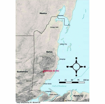
Figure 1. Location of the ancient Maya site of Quebrada de Oro in the southern Maya Mountains of Belize.
Ancient Maya causeway systems tend to be more ubiquitous in the northern Maya lowlands than in the southern Maya lowlands (Shaw Reference Shaw2001: 267); a similar north-south contrast exists within the area that is today Belize. While numerous causeways are known to emanate from certain sites north of the Maya Mountains divide (e.g. Caracol and Tipan Chen Uitz), relatively few causeways have been located south of the divide. Those causeways that have been discovered in the south are generally short (<100m) and function as axis-ways located within central architectural groups, rather than longer routes into the surrounding territory. Recent work at the site of Quebrada de Oro, however, has revealed a causeway system unlike any other in southern Belize, and one that is more akin to those found farther north. A preliminary description of this causeway system, and its implications for the site of Quebrada de Oro, is provided below; a more detailed investigation of the causeway system is planned.
Background
Peter Dunham (Reference Dunham1987) and J. Jefferson MacKinnon (Reference MacKinnon1989: 466–68; n.d.) were the first archaeologists to survey and produce pace-compass maps of the central architectural complex associated with Quebrada de Oro. Since then, the full extent of the site has only been perfunctorily explored due to the logistical difficulties of access in the area (e.g. Dunham et al. Reference Dunham, Murray, Gall and Meurer1993; Abramiuk et al. Reference Abramiuk, Wanyerka and Pesek2009). As a result, we still lack a complete archaeological map of the site.
Although a stone-lined causeway was observed by MacKinnon (n.d.) in the 1980s, emerging from the south-east corner of the Quebrada de Oro central architectural group, it was believed to have terminated approximately 20m away at a large tree and was not investigated further. It was not until 2013 that a documentary team led by the author, tasked with recording a stela at the site (see Abramiuk et al. Reference Abramiuk, Wanyerka and Pesek2009), came across a segment of the same stone-lined causeway farther afield. In 2016, the Quebrada de Oro Mapping and Inventorying Project, funded by California State University Channel Islands, was launched to establish the route and length of the causeway and to map it and the site's central structures using a total station, in addition to excavation of the stela. This short paper presents only the results related to the causeway.
Description
The causeway uncovered at Quebrada de Oro originates from the south-eastern corner of the central architectural group and joins another causeway from the north-north-west approximately 15m from the south-eastern corner of the main group. Together they merge and continue in a south-south-easterly direction as a single causeway for nearly 500m, terminating at a relatively massive five-structure complex. The southern segment of the causeway passes a number of small structures as well as a stela that abuts the eastern edge of the causeway (Figure 2).
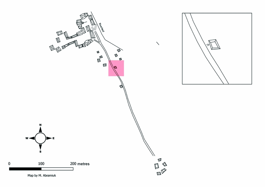
Figure 2. An incomplete site plan of the ancient Maya site of Quebrada de Oro, showing a dendritic causeway system linking the central architectural complex with another architectural group. The inset shows a stela flanked by a platform and the causeway.
The north-north-western branch, on the other hand, appears to originate in the northern plaza of the central architectural group, and is joined by another causeway from the north-north-east (shown as dotted lines in Figure 2). This latter branch was not mapped and was not explored due to lack of time, but its bearing suggests that it has an origin somewhere north of the main group, possibly on the other side of the riverbed. The multiple northern branches give the causeway a dendritic appearance. Each branch has a standardised width of approximately 2.5m. The structural characteristics of the causeway system, however, are not standardised. Even though the northern part of the causeway, including its multiple branches, is stone-lined and appears to be level with the ground (Figure 3), the southern part is raised and is built of large cut and uncut stones (Figure 4).
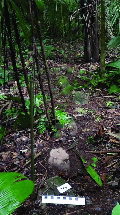
Figure 3. Northern (stone-lined) segment of the causeway, looking north-west up the causeway. Black and white checked scale is 22cm across.
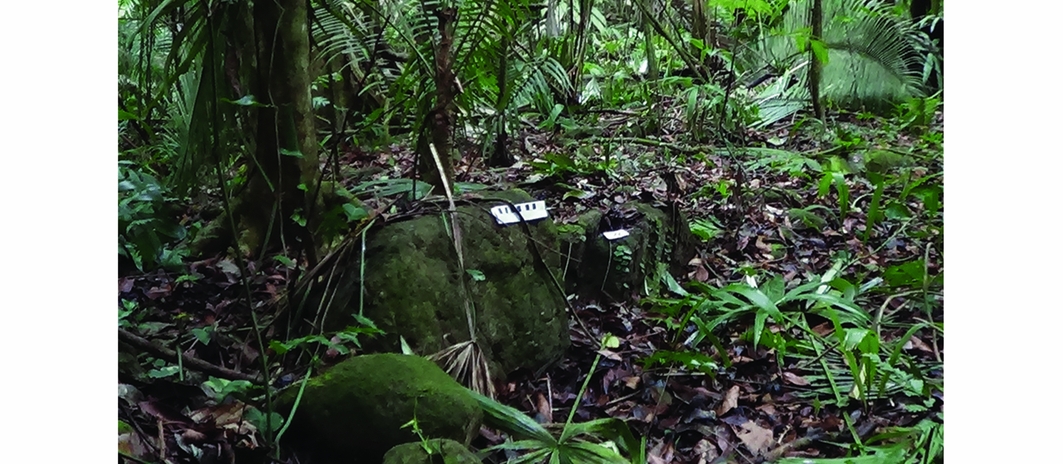
Figure 4. Southern (raised) segment of the causeway built with large cut and uncut stones, looking west-north-west at the eastern edge of the causeway. Black and white checked scale is 22cm across.
Implications and future work
Causeways had multiple purposes, but one important function was to extend the reach of Maya centres and to assert political authority (Webster Reference Webster, Boone and Willey1988: 23). Indeed, it is this motive that has been proposed for the causeways we find at the huge site of Caracol (Chase & Chase Reference Chase and Chase2001), and there is no reason to suggest that the manner in which power was wielded there was any different than at Quebrada de Oro, particularly considering the resemblances between the causeway systems of the two sites. Both systems are dendritic in form, linking architectural groups into a single cohesive political and civic-ceremonial centre. In this sense, causeways can be seen as stark expressions of political control. The identification of a causeway at Quebrada de Oro—and their absence at the other Bladen Branch sites—may suggest that Quebrada de Oro wielded greater political control over its territory than did its neighbouring communities, or, at the very least, that it expressed its political power more assertively. Future work will seek to measure the reach and degree of Quebrada de Oro's political control as expressed through its causeways. Assessing these characteristics will constitute a first
step towards understanding social power at Quebrada de Oro and, ultimately, how this ancient centre interacted with its neighbours.
Acknowledgements
I would like to thank the Institute of Archaeology of Belize, the Forest Department and Ya'axche’ Conservation Trust for permitting me to undertake archaeological operations at Quebrada de Oro. I am also indebted to the California State University Channel Islands for its enduring support of the project.


