


Introduction
The overall geology of the central Transantarctic Mountains is well established (e.g. Barrett Reference Barrett and Tingey1991, Elliot Reference Elliot, Hambrey, Barker, Barrett, Bowman, Davies, Smellie and Tranter2013, Goodge Reference Goodge2020). There are, however, numerous outcrops that either have not been investigated or have only been cursorily examined, sometimes with the thought that a later expedition would enable a thorough investigation. This paper discusses a case of the latter at Schroeder Hill, near the head of the Shackleton Glacier (Figs 1 & 2), which has been only briefly examined. It was first visited in the 1970–1971 field season by Collinson & Elliot (Reference Collinson, Elliot, Turner and Splettstoesser1984), who reported the occurrence of Triassic strata, and subsequently by several investigators during the 1995–1996 field season and again briefly in the 2007–2008 field season. The Victoria Group beds exposed at Schroeder Hill belong to the Triassic Fremouw and Falla formations, which are intruded by Lower Jurassic Ferrar Dolerite sills. Surficial deposits consist of weakly lithified sandy sediments that are assigned to the pre-mid-Miocene glacigenic Sirius Group (Barrett Reference Barrett2013) and unconsolidated post-Miocene moraines related to current glacial drainage.
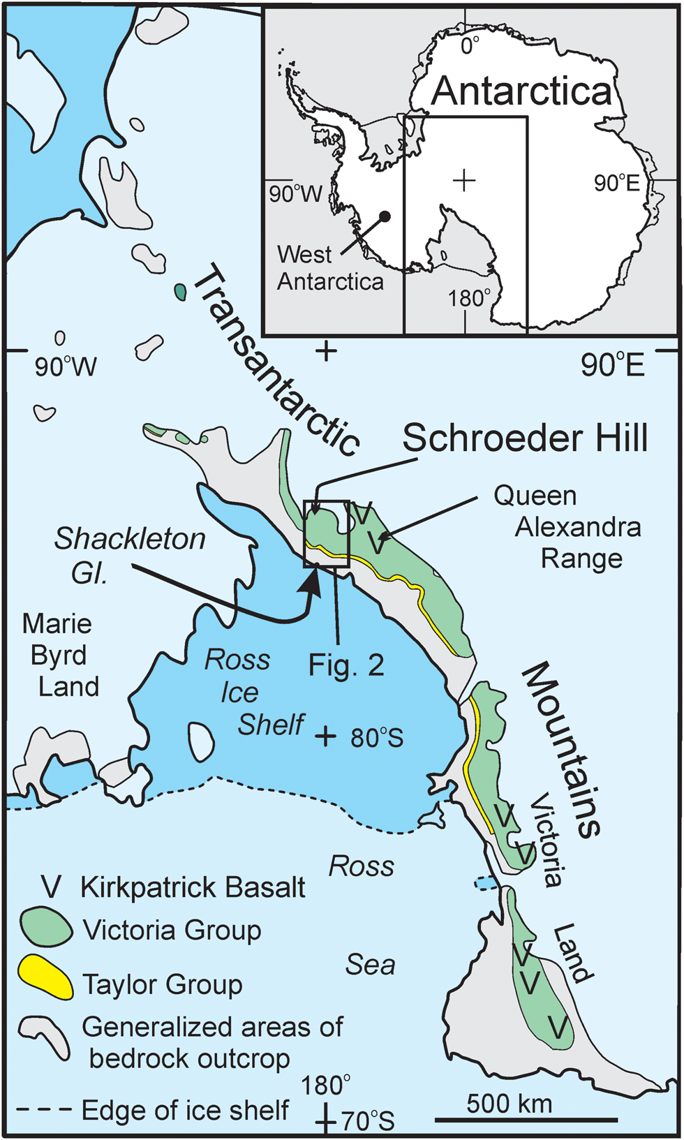
Fig. 1. Location of Schroeder Hill, central Transantarctic Mountains, Antarctica.

Fig. 2. Geological sketch map of the Shackleton Glacier region. Dashed red lines between Mount Wade and Cape Surprise are the interpreted positions of major faults (Miller et al. Reference Miller, Fitzgerald and Baldwin2010).
The objective of this short paper is to record the local Triassic stratigraphy, the apparent deformation of Fremouw Formation strata and the occurrence of Sirius Group beds. Comparisons are made with correlative strata in the upper Shackleton Glacier region and at Otway Massif. Structural data are noted in the context of the Cenozoic uplift of the Transantarctic Mountains.
Geology of the Shackleton Glacier region
Pre-Devonian basement rocks (Fig. 3) consist of metasedimentary and metavolcanic rocks of Precambrian to Early Palaeozoic age intruded by Cambrian to Lower Ordovician granitoids of the Ross Orogenic Belt (Goodge Reference Goodge2020). In pre-Devonian time, the Ross Orogen was eroded extensively to form the Kukri Erosion Surface. On that surface unfossiliferous sandstones were deposited, now represented by thin successions at scattered outcrops (Coates Reference Coates, Turner and Splettstoesser1985, Isbell Reference Isbell1999). These beds are stratigraphically correlative with the Devonian Taylor Group of southern Victoria Land (Bradshaw Reference Bradshaw, Hambrey, Barker, Barrett, Bowman, Davies, Smellie and Tranter2013). A pre-Permian erosion surface (Maya Erosion Surface) was developed across all older rocks, and on this younger surface the Permian-Triassic Victoria Group strata accumulated. The Permian strata comprise the glacigenic Pagoda Formation, the post-glacial shales and fine sandstones of the Mackellar Formation, the deltaic sandstones of the Fairchild Formation and finally the coal-bearing Buckley Formation, which contains a significant detrital volcanic component (Collinson et al. Reference Collinson, Elliot, Isbell, Miller, Miller, Veevers and Powell1994). The overlying Triassic Fremouw fluvial beds are, for the most part, non-carbonaceous, and the sandstones have a lesser volcanic component than the Buckley strata. Fluvial deposition continued with the accumulation of the Falla Formation, which has minor coal and lacks volcanic detritus (Collinson et al. Reference Collinson, Elliot, Isbell, Miller, Miller, Veevers and Powell1994). The Fremouw and Falla strata are exposed in the upper reaches of the Shackleton Glacier (Fig. 4). Overlying the Falla beds are silicic volcanic beds and sandstones of the Lower Jurassic Hanson Formation (Elliot et al. Reference Elliot, Larsen, Fanning, Fleming and Vervoort2017b). This formation is not present at the head of the Shackleton Glacier, but to the west it is poorly exposed at Otway Massif (Fig. 2). Deposition of the Hanson strata was followed by pyroclastic deposits and flood lavas of the Prebble Formation and Kirkpatrick Basalt (Elliot et al. Reference Elliot, White, Fleming, Smellie, Panter and Geyer2021), which are exposed to the south-west and west in the Grosvenor Mountains and at Otway Massif (Fig. 2) (Elliot et al. Reference Elliot, Barrett and Mayewski1974). The intrusive equivalent of the basaltic rocks, the Ferrar Dolerite, forms numerous thick sills (commonly 100–200 m thick) and occasional dikes cutting Victoria Group strata (Elliot & Fleming Reference Elliot, Fleming, Smellie, Panter and Geyer2021).

Fig. 3. Simplified stratigraphic column for the central Transantarctic Mountains (Queen Alexandra Range to the Shackleton Glacier region).

Fig. 4. Geological sketch map of the upper Shackleton Glacier region. Sirius Group localities at Half Century Nunatak, Dismal Buttress and Roberts Massif are from Hambrey et al. (Reference Hambrey, Webb, Harwood and Krissek2003). Extensive dolerite surfaces at Roberts Massif, at Schroeder Hill and to the south-east have a veneer of surficial debris. ‘Alfie’s Elbow' is located within the box outlining Fig. 5.
Schroeder Hill
A sketch map of the geology of the ‘Alfie’s Elbow' (unofficial name) region, which lies to the south-east of Schroeder Hill itself, is presented in Fig. 5. It is based on limited field observations and aerial photograph interpretation. The ‘Alfie’s Elbow' Triassic succession is well exposed and includes several intervals with abundant plant debris. A detailed ~42 m section was documented by Axsmith et al. (Reference Axsmith, Taylor, Taylor and Cuneo2000); the age assigned was late Middle to early Late Triassic, and stratigraphically it was assigned to either the upper Fremouw Formation or the lower Falla Formation. Locally on the dip slope south-west of the ‘Alfie’s Elbow' ridge, in-place tree stumps are present, which leads to assignment of beds at that locality to the Fremouw Formation. From a lithostratigraphic perspective, the section measured by Axsmith and others belongs to the upper Fremouw Formation because the change to the quartzose Falla Formation occurs higher stratigraphically.

Fig. 5. Geological sketch map of the ‘Alfie’s Elbow' region of Schroeder Hill. A small remnant of basal Falla beds, in the form of quartz-pebble conglomerate, is inferred on the Fremouw dip slope south-west of ‘Alfie’s Elbow' and is indicated by the enclosed dashed white line. The heavy dashed black line indicates the location of the inferred fault juxtaposing the Fremouw and Falla beds. The horizontal line pattern to the left of the Ferrar Dolerite sill denotes dolerite overlain by surficial debris. Attitude symbols indicate low dips to the south-south-west. Enlarged from Polar Geospatial Center/USGS aerial photo TMA 788 033 F32(V).
Approximately 3 km north-east of Schroeder Hill (Fig. 4) there is a thick (≥ 271 m) sequence of Fremouw strata, although the upper part is poorly exposed (Section 91, Collinson & Elliot Reference Collinson, Elliot, Turner and Splettstoesser1984). That upper part appears to consist of several cycles of thick sandstones, and their slope-forming aspect suggests that they are volcaniclastic Fremouw strata. To the north-west of Schroeder Hill, the Fremouw beds consist of thick sandstones and intervals of finer-grained beds, which include palaeosols (D.H. Elliot, unpublished data, 2007–2008 field season).
The short section reported in Axsmith et al. (Reference Axsmith, Taylor, Taylor and Cuneo2000) is part of a succession > 150 m thick that is well exposed in that immediate region. The abundant carbonaceous beds at ‘Alfie’s Elbow' (Axsmith et al. Reference Axsmith, Taylor, Taylor and Cuneo2000) are in contrast with the upper Fremouw successions exposed near Schroeder Hill and at Mount Augustana (Fig. 2), where they are absent (Collinson & Elliot Reference Collinson, Elliot, Turner and Splettstoesser1984).
The Falla Formation is exposed south-west of ‘Alfie’s Elbow' (Fig. 5). It forms the light-coloured sandstones that crop out eastwards towards Pt 2840 (location on Fig. 4) and in scattered outcrops to the south-east as far as Last Cache Nunatak. Quartz-pebble conglomerates on the Fremouw dip slope south-west of ‘Alfie’s Elbow' are regarded as basal Falla beds, in keeping with a similar lithological transition to pebbly quartzose sandstones at Misery Peak (Collinson & Elliot Reference Collinson, Elliot, Turner and Splettstoesser1984). Without detailed mapping and section measuring, the Fremouw/Falla contact cannot be adequately defined here. The measured (~100 m thick) but incomplete section of Falla beds, which is capped by a dolerite sill, crops out on a north-east-facing slope and is located south-west of ‘Alfie’s Elbow' (Fig. 5). It consists largely of quartzose sandstones, some massive, but with finer-grained intervals and rare carbonaceous beds and coal (Fig. 6a). The quartz-pebble conglomerate, apart from pointing to a major provenance change, also suggests the possibility of a disconformity between the Fremouw and Falla beds, as does the significant channelling in the Falla succession at Misery Peak (Collinson & Elliot Reference Collinson, Elliot, Turner and Splettstoesser1984).

Deposits interpreted as part of the Sirius Group occur in two separate places south-east of ‘Alfie’s Elbow' (Figs 5 & 7). An unmeasured stratigraphic succession consisting of poorly lithified, fine-grained beds with occasional thin, sandy intervals rests on modern topography (Fig. 7, site 1 & Fig. 8a). At the second locality (Fig. 7, site 2 & Fig. 8b), pockets of unbedded quartzose sandstone are tucked under resistant Fremouw sandstone ledges. Sirius deposits appear to form a veneer plastered on the Fremouw outcrops north-west of Schroeder Hill itself, and Sirius-like weakly lithified sandstone clasts occur in moraines in that vicinity.


Fig. 8. a. Closer view of gently folded Fremouw beds in contact with Sirius strata. The white dashed line marks the contact. The black dashed line marks bedding in Sirius strata. The direction of the view is indicated in Fig. 7a. b. Pale-coloured Sirius Group sand wedged under dipping Fremouw strata located at the south-east edge. This is the south-east edge of Sirius Site 1 in Fig. 5. The direction of view is indicated on Fig. 7b.
Structure
Fremouw beds at ‘Alfie’s Elbow' have a low south-westerly dip towards the Zaneveld Glacier (attitude measurements are uncertain because of surface disruption, but the regional dip is apparent in the field and on aerial photographs of the region). The sill forming the ridge crest above the Falla section (Fig. 5) can be traced to the north-west and on the north-west-facing slope below Schroeder Hill dips towards the Zaneveld Glacier. The sill appears to be concordant with Fremouw beds at the north-east end of that slope.
Carbonaceous beds of the Fremouw Formation are gently folded (Fig. 8a). The fold axis is oriented approximately west-north-west to east-south-east. To the east of this outcrop, Fremouw beds are replaced by light-coloured Falla strata; a north-east to south-west-trending fault, down to the south-east, is inferred to occupy a prominent gulley adjacent to the Sirius localities (Fig. 5).
Faulting/tectonics
Range-parallel normal faults, down to the north-east, are common in the Shackleton Glacier region, from the mountain front at Cape Surprise to Roberts Massif (Barrett Reference Barrett1965, LaPrade Reference LaPrade1965, McGregor & Wade Reference McGregor and Wade1969, Miller et al. Reference Miller, Fitzgerald and Baldwin2010). Faulting is associated with Cenozoic uplift of the Transantarctic Mountains and crustal stretching in the Ross Sea-Ross Ice Shelf sector of the West Antarctic rift system, which lies between Marie Byrd Land and the Transantarctic Mountains (Fig. 1). Offsets are demonstrated in the pre-Devonian basement rocks by mapping and offset apatite fission-track age profiles (Miller et al. Reference Miller, Fitzgerald and Baldwin2010), and faults have been inferred by stratigraphic offsets (LaPrade Reference LaPrade1965) from south of Mount Butters to Roberts Massif, with an overall west-north-west to east-south-east strike of ~125°. Most faults documented by stratigraphic offsets and interpretation of the fission track data suggest simple back-rotated fault blocks, except for the Mount Heekin region, which was interpreted by LaPrade (Reference LaPrade1965) to form a graben, flanked to the north-north-east by a narrow horst.
The south-westerly dip of the Triassic strata at ‘Alfie’s Elbow', perpendicular to the trend of major faults, is similar to the apparent dip of Triassic strata at Mount Black, Roberts Massif and Everett Nunatak (measured or inferred from aerial photograph interpretation and assuming overall sill intrusion parallel to bedding). The dipping strata at ‘Alfie’s Elbow' are therefore interpreted as another fault block bounded to the north-north-east by a fault along the Logie Glacier and to the south-south-west by a fault along the Zaneveld Glacier. A previously undocumented fault (from aerial photograph interpretation), also down to the north-north-east, is located in the southern part of Roberts Massif.
Documented faults extend inland from the Cape Surprise fault (Fig. 2) for 100 km and might occur farther south between Roberts Massif and the Grosvenor Mountains. In the Queen Alexandra Range and upper Beardmore Glacier region (Elliot et al. Reference Elliot, Fanning, Isbell and Hulett2017a), probable Cenozoic faults and monoclines have been recorded at a similar distance from the frontal fault.
The inferred Falla beds east of the fold at ‘Alfie’s Elbow' require a normal fault separating those strata from the Fremouw beds. The strike of that fault (Fig. 5) is approximately perpendicular to the regional range-parallel trend of faulting.
The strike of the apparent fold axis observed near ‘Alfie’s Elbow' and the associated arching of the Fremouw beds (Fig. 5) are parallel to the regional normal faulting at Roberts Massif. The arching of the Triassic beds suggests possible draping over a normal fault having minor displacement.
Regional correlations
Fremouw Formation strata are widely distributed in this region, cropping out at Misery Peak and extending at least as far north as Mount Augustana, east of the Shackleton Glacier, and to the west to Mount Boyd and Layman Peak (Fig. 2). The Falla Formation is present at Misery Peak (Fig. 4) (Collinson & Elliot Reference Collinson, Elliot, Turner and Splettstoesser1984) and occurs across much of Roberts Massif. At Misery Peak, the Falla beds consist of thick sandstone cycles (the basal cycle is 85 m thick) and represent a major fluvial system in which channels up to 10 m deep were developed. The Misery Peak succession differs from that down-palaeoflow in the Queen Alexandra Range ~200 km distant in that the sandstone cycles are thicker, and the Schroeder Hill succession differs in the occurrence of coarse quartz-pebble conglomerate in the basal unit, which suggests deposition closer to the source. The limited detrital zircon data (Elliot et al. Reference Elliot, Fanning, Isbell and Hulett2017a) also mark a provenance change from one with Ross Orogen-, Palaeozoic- and Triassic-age zircons in the Fremouw Formation to Ross Orogen- and Triassic-age grains alone in the Falla Formation.
Triassic beds, some with Dicroidium and some with quartz pebbles, occur at Otway Massif (Figs 2 & 9), where they form megaclasts within an Early Jurassic phreatocauldron associated with the Ferrar Large Igneous Province (Elliot et al. Reference Elliot, White, Fleming, Smellie, Panter and Geyer2021). The varied attitudes of the Triassic beds demonstrate that they are deformed and displaced and not in situ. In Fig. 9, the section labelled A* (Fig. 6, column B) includes volcaniclastic sandstones, whereas the short section labelled A† is predominantly fine grained and volcaniclastic and contains Dicroidium leaf remains. Both sections are assigned to the Fremouw Formation. Quartzose Falla sandstones occur at the locations labelled B in Fig. 9. A 15 m-thick pebbly quartz sandstone (at locality C in Fig. 9) might belong to the Falla Formation, but angular K-feldspar clasts suggest that the Hanson Formation is a more likely assignment; however, it includes carbonaceous laminae, which are not known elsewhere in that formation. A 55 m-thick section of the Hanson Formation crops out at locality D in Fig. 9 (Elliot et al. Reference Elliot, Larsen, Fanning, Fleming and Vervoort2017b).
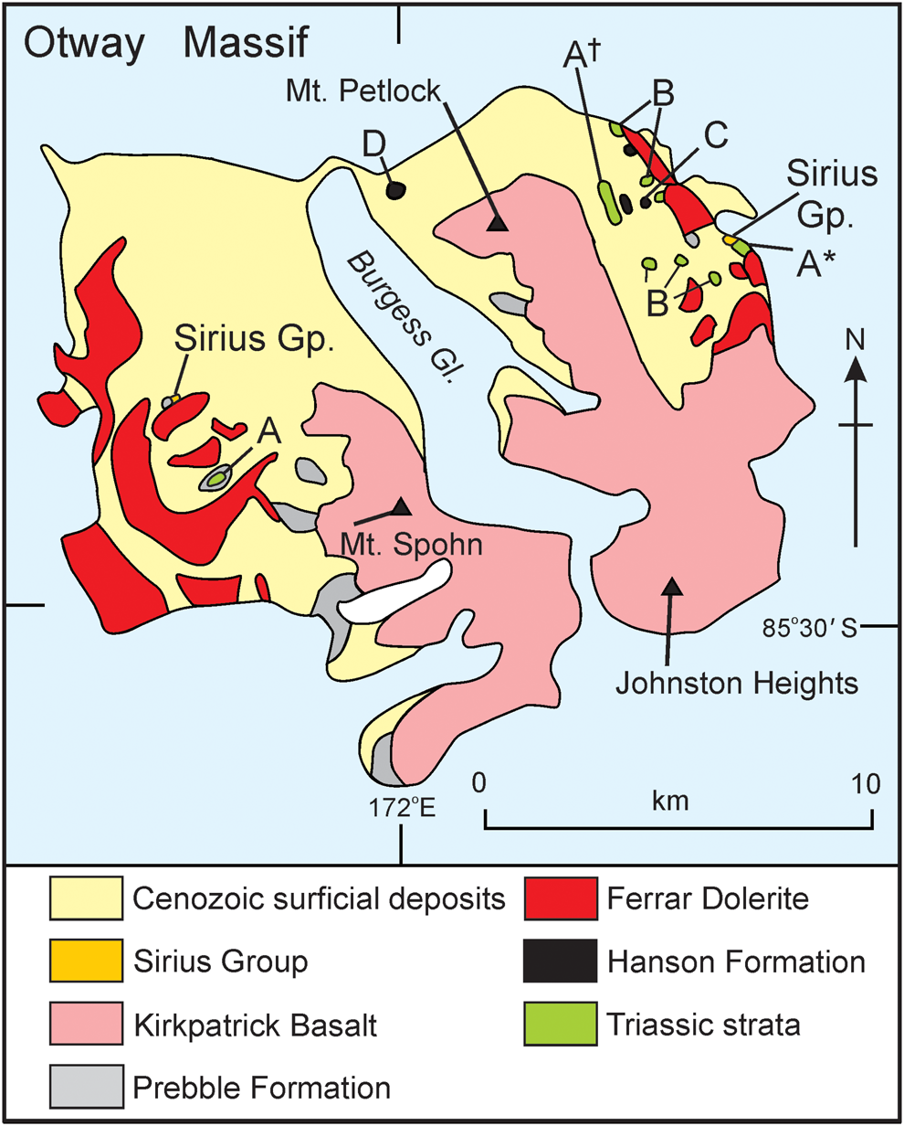
Fig. 9. Location map for Otway Massif. Site A: Fremouw Formation megaclasts; Site A*: location of the Fremouw Formation section illustrated in Fig. 6; site A†: see text; sites labelled B: Falla Formation megaclasts; Site C: possible Hanson Formation outcrop; Site D: Hanson Formation strata. Map modified from Elliot & Hanson (Reference Elliot and Hanson2001).
Sirius Group deposits are known to occur across Roberts Massif, where there are numerous sites, and at Dismal Buttress and Half Century Nunatak (Fig. 4) (McGregor Reference McGregor1965, Mayewski Reference Mayewski1975, Mayewski & Goldthwait Reference Mayewski, Goldthwait, Turner and Splettstoesser1985, Hambrey et al. Reference Hambrey, Webb, Harwood and Krissek2003). A pocket of Sirius sediment is lodged in a cleft cut into Kirkpatrick Basalt lava that forms the summit ridge of Mount Block (Fig. 2) (Mayewski & Goldthwait Reference Mayewski, Goldthwait, Turner and Splettstoesser1985, D.H. Elliot, unpublished data, 1967–1968 field season), and there are at least two outcrops at Otway Massif (Fig. 9). On the east flank of the massif, Sirius-like sediment overlies Triassic beds, whereas west of Burgess Glacier it occurs as a small, isolated pocket (Elliot et al. Reference Elliot, Barrett and Mayewski1974, Mayewski & Goldthwait Reference Mayewski, Goldthwait, Turner and Splettstoesser1985). The Sirius sediment at Mount Block suggests that deposition dated from a time when ice overrode the Grosvenor Mountains, as inferred by Mayewski & Goldthwait (Reference Mayewski, Goldthwait, Turner and Splettstoesser1985).
Conclusions
The stratigraphic succession in the Shackleton Glacier region between the Triassic Fremouw Formation and the Lower Jurassic Kirkpatrick Basalt is fragmentary and incomplete. The Schroeder Hill region adds to the Triassic stratigraphic information, in particular the carbonaceous nature of the upper Fremouw strata and the very distinctive quartz-pebble conglomerate that must represent the basal Falla beds and a significant change in provenance. The stratigraphy can be compared to the well-exposed succession in the Queen Alexandra Range (Elliot Reference Elliot, Hambrey, Barker, Barrett, Bowman, Davies, Smellie and Tranter2013). The distribution of Cenozoic Sirius Group deposits is extended to the ‘Alfie’s Elbow' region and to an additional site at Otway Massif. Interpretation of the south-south-westerly dip of the Triassic beds in the ‘Alfie’s Elbow' region adds to the regional structure of back-dipping fault blocks associated with the Cenozoic uplift of the Transantarctic Mountains. It is probable that one or more additional faults occur between Roberts Massif and the Grosvenor Mountains.
Acknowledgements
The fieldwork on which this paper is based was conducted principally in the 1970–1971 and 1995–1996 field seasons. Support was provided by the Office of Polar Programs, National Science Foundation (principally NSF grants GA-26652 and OPP 94-20498 to DHE and OPP 93-15826 to W.R. Hammer for JWC). We thank Peter Barrett and Paul Fitzgerald for careful reviews, which have improved the manuscript. This is Byrd Polar and Climate Research Center contribution number C-1613.
Author contributions
DHE: data acquisition, interpretation and manuscript preparation. JWC: data acquisition, interpretation and manuscript review.


 Open access