


Introduction
Rock glaciers are a common landform in high Alpine areas. In recent years there has been a renewal of interest in the climatic and geomorphic significance of these features. Rock glaciers are the cumulative expression of their entire history and, thus, in a complex way, of their present and past environment. Comparisons of their actual thermal and dynamic behaviour, on the one hand, and their shape, on the other hand, enable conclusions to be drawn about past environmental conditions. Since rock glaciers are a phenomenon of creeping mountain permafrost, climate is― in addition to other factors such as geology, ice/water availability, etc. ― one of the main controlling factors of their existence. The decoding of the present-day morphology and distribution of rock glaciers, and a better knowledge of the climatic controls on rock glaciers provide important information on past and present climatic conditions.
In this paper the focus is on the distribution and morphology of rock glaciers in the Swiss Alps, with the aim of reconstructing their evolution in both historical and morphological terms. A number of investigations (geophysical soundings, borehole measurements, BTS (bottom temperature of snow cover) mapping, spring water temperatures, etc.) have shown that the rock glaciers dealt with in this study represent creeping mountain permafrost (Reference BarschBarsch, 1978; Reference HaeberliHaeberli, 1985; Reference Haeberli, Hoelzle, Kääb, Keller and Vonder MuhllHaeberli and others, 1998; Reference Vonder Muhll, Stucki and HaeberliVonder Muhll and others, 1998). For our study the mere existence of the rock glaciers and the creep of the frozen debris is considered, regardless of the origins of the rock glaciers.
While considering two different time-scales, the Holocene and the Alpine Late Glacial, we follow two approaches:
-
(1) a photogrammetry-based analysis of the morphology and dynamics of selected active rock glaciers, in order to derive their age structure and two theoretical concepts of shape types for active/inactive rock glaciers;
-
(2) an inventory-based investigation of the spatial distribution of relict rock glaciers in order to estimate past limits of Alpine permafrost distribution.
From the synthesis of these two approaches we then assess the potential of single rock glaciers or groups of rock glaciers for estimating variations of palaeoclimate on a time-scale of millennia.
Approach 1: Kinematics
The present-day morphology of active rock glaciers reflects, not primarily their present dynamic state, but rather their dynamic history. Hence, complex and non-coherent shapes, rich in vertically and horizontally distinguishable creep systems, might point to a complex history, whereas uniform creep streams could represent a history of less dynamic variations. Furthermore, inactive and relict rock glaciers were obviously more active in the past than they are at present. Therefore, the potential significance of rock glaciers for palaeoclimatic conclusions strongly depends on their age and the expressiveness of their dynamic history. Many independent dating methods point to a general rock-glacier age in the range of millennia (e.g. relative age dating: Reference BirkelandBirkeland, 1973; surface weathering: Reference Kirkbride and BrazierKirkbride and Brazier, 1995; Reference HumlumHumlum, 1998; fossil soils: Reference JohnsonJohnson, 1998; geochemical data: Reference Steig, Fitzpatrick, Potter and ClarkSteig and others, 1998; radiocarbon age: Reference HaeberliHaeberli and others, 1999). At the same time, such studies give concise evidence that rock glaciers can display a complex, multi-system temporal behaviour.
Uniform morphology
In this study a photogrammetric approach was used to assess the age and the spatio-temporal age structure of selected active rock glaciers in the Swiss Alps. Using analytical photogrammetry multitemporal digital terrain models (DTMs) were determined in order to obtain the spatial pattern of surface elevation changes. Entire surface flow fields were derived from the comparison of repeated imagery and subsequently used for streamline calculations. For details on methodology refer to Reference Kääb, Haeberli and GudmundssonKääb and others (1997, Reference Kääb, Gudmundsson and Hoelzle1998). By working out some general conclusions rather than giving a specific analysis of these two objects, the related results are demonstrated using Murtèl and Muragl rock glaciers (Upper Engadine, Swiss Alps; see Fig. 1).
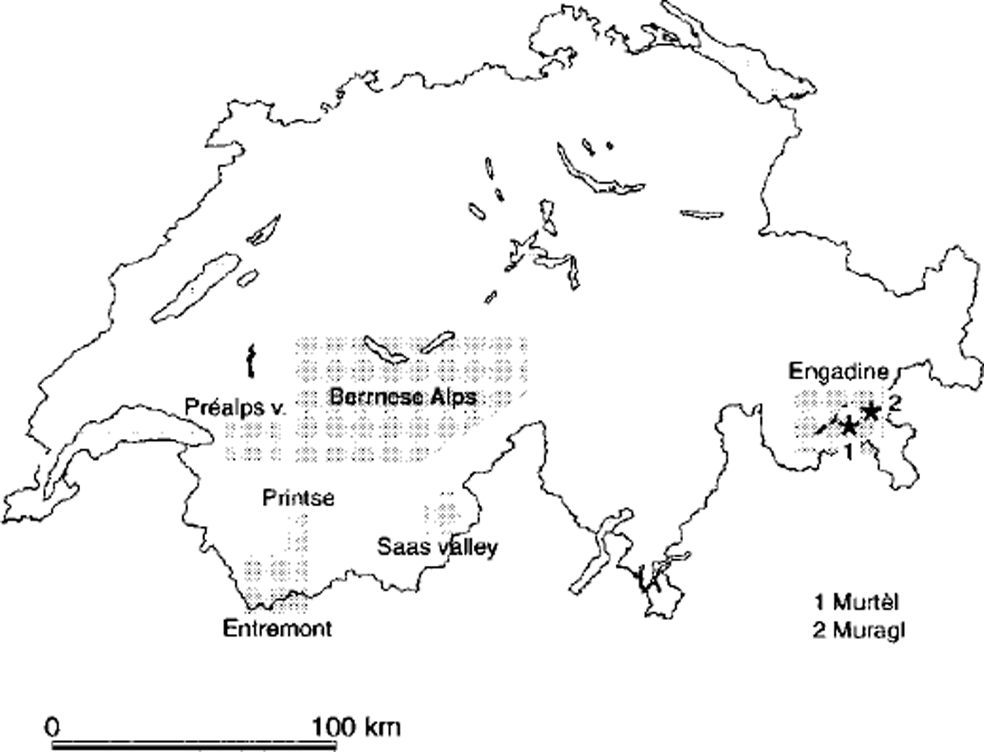
Fig. 1. Sketch map of Switzerland, showing the locations of the two active rock glaciers and the extent of the six rock-glacier inventories discussed in this paper.
The changes in elevation on the lower part of Murtèl rock glacier between 1987 and 1996 show a conspicuous pattern, with surface lowering of up to 0.1 m a"1 on the back of the transverse ridges, and almost unchanged elevation on the front of the ridges with respect to flow direction (cf Reference Kääb, Gudmundsson and HoelzleKääb and others, 1998). This pattern results from two overlying processes: (a) a general loss of permafrost thickness by some 10–2 m a–1, and (b) the advance of surface topography relative to the spatially fixed photogrammetric coordinate system. Separating the low-frequency effect (a) and the high-frequency effect (b), and considering the slopes of the surface relief enables the calculation of an advance rate of the ridges which approximates 0.05 m a–1. This rate fits very well with the photogrammetrically derived surface velocity field of 1987–96 which shows surface velocities of a similar magnitude (Fig. 2). The transverse surface ridges on Murtèl rock glacier propagate downstream with a velocity that approximately equals that of the surface rocks. This has been shown also for other rock glaciers (Reference White, Giardino, Shroder and VitekWhite, 1987; Reference KääbKääb, 1998), so it does not seem to be a random result just for this specific rock glacier and the given observation period. Therefore, we conclude that the surface topography reflects the creep of the permafrost body and can be used as an indicator of the creep field. In that way, the central stream of Murtèl rock glacier seems to represent one single creep system of cumulative and continuous deformation from the rock wall to the front. In our study this morphology type is called ˚monomorphic". However, bearing in mind the immense variety of rock-glacier shapes in nature, such a definition can only be theoretical. As a consequence, our idea of a "mono-morphic" rock glacier refers to the central part of Murtèl rock glacier rather than to the entire rock glacier. In fact, interpretation of the very slow or even no-creeping lateral parts is difficult. These zones could have a dynamic origin (e.g. marginal shearing) and therefore be parts of the main stream, or they could be relicts of an older stage of the rock glacier and indicate some temporal variation in activity

Fig. 2. Horizontal surface velocities of Murtèl rock glacier over the period 1986–96, measured by computer-aided photogrammetry.
The age structure of Murtèl rock glacier was assessed from streamlines interpolated from the velocity field (Fig. 3, left). Under steady-state conditions these streamlines would represent the trajectories of specific particles on the surface and could thus be used for rock-glacier age estimates. It is clearly hypothetical and certainly critical to assume that the current velocities of Murtèl rock glacier approximately average the velocity fields of a lengthy time period in the rock-glacier evolution. However, this assumption seems justified by the fact that at Murtèl rock glacier (Fig. 3, left) the curvature of the isochrones (represented by dots of the same age) is similar to that of the transverse ridges. Since the surface topography presumably represents the cumulative surface deformation, as shown above, the average surface velocities over a long period of the rock glacier’s existence must have been similar to the current velocities that underlie the calculated streamlines. In principle, the temporal average of velocities but not the temporal variability is considered. Nevertheless, in view of the coherent evolution of the ridge-and-furrow sequence (cf. Reference Kääb, Gudmundsson and HoelzleKääb and others, 1998), strong temporal variations in the kinetic history of Murtèl rock glacier seem unlikely.

Fig. 3. Streamlines interpolated from the velocity fields of Murtèl rock glacier (left) and Muragl rock glacier (right). Bold dots represent a tine-span of 1000 years.
The streamline isochrones indicate that the surface development of the central stream on Murtèl rock glacier took approximately 6kyr. This age estimate for the central part is independent of the implications for the less active lateral parts (see above). Even introducing an error of some 10% for the above assumption of average velocities does not substantially affect the basic conclusion that the surface age of Murtèl rock glacier amounts to several (i.e. at least 4 or 5) kyr (cf Reference HaeberliHaeberli and others, 1999). Relating this surface age to the present advance rate of the creeping body (about 0.01 m a"1), derived in the same manner as for the ridges, results in a significantly higher total age of the whole rock glacier.
Complex morphology
The velocity field and the surface topography of Muragl rock glacier have a starkly contrasting appearance. The flow field of Muragl rock glacier between 1981 and 1994 reveals the rock glacier to be a complex system of several creep streams (even inactive ones, e.g. close to the northern margin) characterized by different velocities and creep directions (Fig. 4). Muragl rock glacier can be viewed as a system of several creep lobes having different behaviour with respect to time and space, partially overriding each other and/or laterally interacting. Internal processes (flow instabilities, mass-deposition feedbacks) or external forcing (climate variations, variations in mass supply) can be hypothesized as the cause of such complex structures. In contrast to the "monomorphic" type described above, this type of rock glacier is called ˚polymorphic" in our study.

Fig. 4. Horizontal surface velocities of Muragl rock glacier for the period 1981–94, determined by computer-aided programmetry.
These two theoretical types differ not only in their velocity field and morphology, but also in their age structure, as estimated from streamlines interpolated from the velocity fields (Fig. 3, right). The assumption that the current velocities approximately equal a temporal average leads to the qualitative conclusion that the surface age of the individual lobes is younger (2–3 kyr) than on Murtèl (atleast4–5kyr). The fact that Muragl rock glacier consists of several vertically overthrusting streams, and has a clearly less active lower part, suggests a much older age of the entire rock glacier than only a few kyr. Taking into account the variety of transverse surface structures on Muragl rock glacier, there is no clear sign of a creep continuum from the rock wall towards the individual lobe fronts. Thus, in contrast to Murtèl rock glacier, the lobes might originate from somewhere intermediately downstream of the rock walls, leaving the above age assessment for the lobes as a maximum estimate. Introducing a large error for the estimation of the average velocities results in an uncertainty of about 0.1–1 kyr, but does not change the general age contrast between the central Murtèl stream and the Muragl lobes. Furthermore, independently of the age estimates for the individual lobes, Muragl rock glacier consists of active streams overriding those of low or even no kinetic activity. This clearly indicates an age structure different from that of the uniform central stream of Murtèl rock glacier.
Approach 2: Spatio-Temporal Distribution
The compilation of six rock-glacier inventories (Reference Delaloye and MorandDelaloye and Morand, 1998; Reference FrauenfelderFrauenfelder, 1998; Reference HoelzleHoelzle, 1998; Reference ImhofImhof, 1998; Reference Reynard, Lambiel and WenkerReynard and others, 1998; Reference SchoeneichSchoeneich, 1998b) of the Swiss Alps (Fig. 1) made it possible to put together a dataset containing 741 individual rock glaciers, 253 of them active, 203 inactive and 285 relict. This dataset was used to study the spatial distribution pattern of relict rock glaciers. The area covered by the six inventories extends from the eastern main Alpine ridge (Engadine) over the Saas region (close to the central main Alpine ridge) to the southwestern Alps of the Valais (Entremont and Printse) and the western northern slope of the Alps (Préalps). Each inventory contains various data about the individual rock glaciers, including the altitude of each rock-glacier front (H ρ).
A new model will now be presented which enables estimation of the permafrost limit since the Alpine Late Glacial by calculating the related lowering of the mean annual air temperature (MAAT) using data on relict rock glaciers.
Our method is based on the following key assumptions: Alpine permafrost reflects, initially, an interplay of temperature and radiation. Thus, creeping mountain permafrost (i.e. rock glaciers) becomes an intercomparable indicator of MAAT if the effect of radiation can be adjusted. Furthermore, the lowest active rock glaciers in a given region can be interpreted as an outline of the lower limit of discontinuous mountain permafrost. Likewise, presently relict rock glaciers have delineated the permafrost limit by the time of their transition from active/inactive to relict rock glaciers, i.e., at the time of their decay.
Our approach follows five calculation steps:
-
(1) The current MAAT at each rock-glacier front (Tρ) is calculated (cf Equation (2)) using present 0°C isotherm altitudes and temperature gradients for each region (source: annals of the Swiss Meteorological Institute).
-
(2) The potential direct solar radiation (Iρ(x, y, z)) is determined for the specific three-dimensional location of each individual rock-glacier front, using Reference Funk and HoelzleFunk and Hoelzle’s (1992) model.
-
(3) The hypothetical altitude is sought for each relict rock glacier considered to be still active. As the potential solar radiation at the rock-glacier fronts is now known, we can use a relation between potential direct solar radiation and MAAT at the limit of permafrost existence (see Equation (1)) as ascertained by Reference Hoelzle and HaeberliHoelzle and Haeberli (1995) to obtain this hypothetical altitude (H lim).
(1)
-
where a and b are constants determined empirically from BTS measurements by Reference Hoelzle and HaeberliHoelzle and Haeberli (1995), and Ip is the potential direct solar radiation at the front of presently relict rock glaciers. Hoelzle and Haeberli’s relation is established in a regionally independent way. Therefore, altitude is not replaced by MAAT in their formula because of the regional variability of the 0°C isotherm. The accuracy of H lim depends on the resolution of the DTM which underlies the calculation. In our study, based on a DTM with a 50 m resolution, the accuracy lies in the range of some meters.
-
(4) The hypothetical MAAT (Tlim) is now obtained by converting the altitude H lim into temperature (as in the first step for H ρ) using Equation (2).
(2) -
where C stands for the elevation of the regional 0°C isotherm, and ∂T/∂h for the regional temperature gradient.
-
(5) The resulting temperature difference, defined as
(3)corresponds to the temperature increase between the time of the rock glacier’s decay and the present day.
There are two factors which may influence the accuracy of our model calculation:
-
(a) For an exact estimate of the temperature difference ΔT, presently relict rock glaciers would have to have reached the lower limit of discontinuous permafrost, a precondition which certainly does not apply for every relict rock glacier.
-
(b) A rock glacier creeps down-valley and might, due to its own microclimate (coarse blocky material, advective heat flow, increased turbulent fluxes), move into non-permafrost areas even in a constant climate.
In fact, these two effects might partially cancel each other out. Still, the temperature difference calculated by our model probably underestimates the real temperature differences, because effect (a) presumably occurs more frequently than effect (b).
Results and Discussion
Approach 1
Morphologic typology and its possible implications for rock-glacier interpretation can be synthesized as follows: The continuous development of a "monomorphic" rock glacier seems to have been widely undisturbed (e.g. by external climate forcing) throughout its existence. No distinct inactivation/reactivation cycles can be detected. Thus, such rock glaciers may have been permanently subject to permafrost conditions. In contrast, ˚polymorphic" rock glaciers may have undergone some strong variations in their degree of activity One of the key causes for these changes in activity is considered to be temporary altitudinal variations of the permafrost limit around the location of the specific rock glacier. In fact, borehole temperatures of different Swiss rock glaciers support this hypothesis: 10 m temperatures in 1997 at Murtèl ("monomorphic") were –1.82°C, at Schafberg 1 ("polymorphic") –0.8°C, and at Schafberg 2 ("polymorphic") –0.3°C (Reference Vonder Muhll, Stucki and HaeberliVonder Muhll and others, 1998).
The age of "monomorphic" rock-glacier streams is estimated in the range of several kyr. Their flow fields show the result of continuous, cumulative deformation. In contrast, the movement of individual, at most a few kyr old, lobes of ˚polymorphic" rock glaciers represents intermittent deactivation or overriding. The relict rock glaciers most likely decayed at the end of the Alpine Late Glacial or the beginning of the Holocene (cf. results of approach 2). Since that time they have been subject to non-permafrost conditions. In contrast, active "monomorphic" rock glaciers must have been predominantly under permafrost conditions since their origin. Active and inactive rock glaciers of the ˚polymorphic-type have experienced several inactivation/reactivation periods and may possibly be viewed as representatives of Holocene climate oscillations. Although effects inside the debris-ice system may be responsible also for a ˚polymorphic-structure (Reference Olyphant, Giardino, Shroder and VitekOlyphant, 1987; Reference Kirkbride and BrazierKirkbride and Brazier, 1995), the following results of the inventory analysis clearly show the climate sensitivity of Alpine rock glaciers.
Approach 2
The analysis of the spatial distribution of rock glaciers in the Swiss Alps (Fig. 5) shows, not surprisingly, a pronounced altitudinal zonation: active rock glaciers occupy altitudinal bands between 2439 and 2878 ma.s.L, whereas the occurrence of relict rock glaciers is generally limited to heights below 2556 m a.s.L, except for the Saas valley, where the mean altitude of the relict rock-glacier fronts is 2480 m a.s.L, with a standard deviation of ±211 m. The group of inactive rock glaciers, including both dynamically and climatically inactive ones, varies between these figures without exceeding the limit given by either the active or the relict objects. The mean elevation difference between currently active and inactive rock glaciers, of about 100 m or about 0.5°C, equals a temperature difference typical for Holocene climate variations. While the mean standard deviation of the altitudinal zonation for active and inactive rock glaciers is in the order of ±76 m, the distribution of the relict rock glaciers varies considerably, with a standard deviation of ±263 m. This indicates quite stable climatic conditions for the active rock glaciers, in contrast to large climate variations and a long time-span for the relict rock glaciers. The present mean annual air temperature (Tρ), the hypothetical temperature Tl im and the resulting temperature difference (AT) for each region are plotted in Figure 6. The general pattern shows a wide range for ΔT from 0.7° to 5.3°C in the various regions. Even taking into account regional factors, such as topographic preconditions, this indicates that some relict rock glaciers likely decayed at the end of the Alpine Late Glacial (eg. Prealps; Reference SchoeneichSchoeneich, 1998a), while others disintegrated during the Holocene.
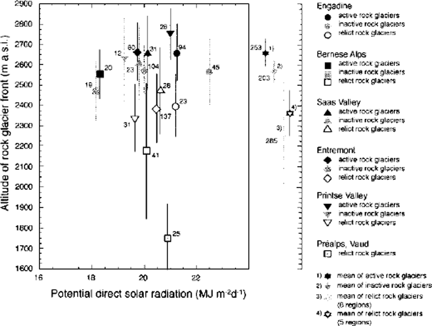
Fig. 5. Mean altitude of active, inactive and relict rock glaciers in six regions of the Swiss Alps, plotted against potential direct solar radiation. .Numbers indicate the random sample sizes. Data are from Reference Delaloye and MorandDelaloye and Morand (1998a), Reference FrauenfelderFrauenfelder (1998) Reference HoelzleHoelzle (1998) Reference ImhofImhof (1998) Reference Reynard, Lambiel and WenkerReynard and others (1998) and Reference SchoeneichSchoeneich (1998b).
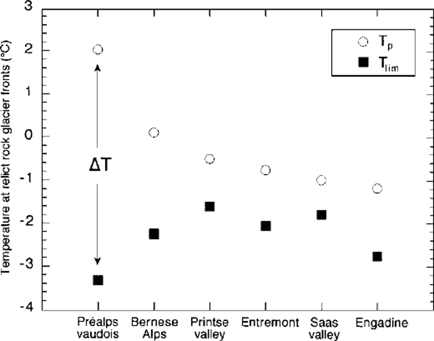
Fig. 6. Comparison of present mean annual air temperature (T p ) at relict rock-glacier fronts vs hypothetical mean annual air temperature (T lim ) if these relict rock glaciers were still at or close to the limit of discontinuous mountain permafrost. ΔT corresponds to the temperature increase between the present day and the time of the rock glacier’s decay.
Looking at the distribution pattern in Figure 5, the relict rock glaciers in the Préalps seem to have a different distribution pattern than those in other regions. Therefore, different values for the variables are given as follows. The mean present temperature (Tρ) at all relict rock glaciers included in the inventories (sixdatasets) is –0.2°C. Excluding the Préalps, the Tp of the other five datasets is –0.7°C. The average of the calculated Tlim is –2.3°C for all relict rock glaciers, –3.3°C for the Préalps and –2.1 °C for the other five datasets (Préalps excluded), meaning that the relict rock glaciers would need this MAAT to be still active. These results are confirmed by the present average MAATat active rock-glacier fronts which approximates –2.4°C (five regions). The values for the individual rock glaciers vary considerably, from –5.7°C (maximum) to+0.8°C (minimum).
The difference ΔT is –5.3°C ± 0.7 for the Préalps and –1.4°C ± 0.7 for the other five datasets. Compared to data on Holocene temperature variations as derived from glacier fluctuations in the Swiss Alps (Reference MaischMaisch, 1992), these values for ΔT clearly exceed the range of the Holocene bandwidth of temperature variations which is estimated to be within 0.5° and 1.0°C by different authors (e.g. Reference Patzelt and BortenschlagerPatzelt and Bortenschlager, 1973; Reference MaischMaisch, 1992). Referring to glacier reconstruction chronologies (Reference MaischMaisch, 1992), A T for the Préalps corresponds to the temperature increase since the end of the Alpine Late Glacial, more precisely since the Oldest Dryas. This value corresponds well with the results obtained by Reference SchoeneichSchoeneich (1998a). The value of ΔT for the other regions corresponds to a temperature increase since the Younger Dryas, or Egesen.
The range of ΔT at individual rock glaciers, varying from –8.2°C (relict rock glacier in the Préalps) to +2.7°C (relict rock glacier in the Saas valley), shows that it is problematic to calculate averages for whole datasets. Nevertheless, the results show the possibility of obtaining initial insights into regional patterns of past permafrost distribution by applying this approach. They also indicate that thorough analyses at individual relict rock glaciers would be a good way to gain more concise information about the depression and the local variation of the past permafrost limit in the Alps.
Conclusions
The results confirm the importance of rock glaciers as highly sensitive indicators of past temperature evolution. Some of the conclusions reached have a definite regional character and cannot be applied directly to other high mountain areas (cf Reference Brazier, Kirkbride and OwensBrazier and others, 1998). Yet, the potential of the presented approach for inventory analyses lies in its ability to draw conclusions about both the fluctuations of the permafrost limit during the Holocene (by studying active/inactive rock glaciers) and the course of the Alpine Late Glacial permafrost limit (by analyzing relict rock glaciers). Comparison of the calculated temperature differences at individual relict rock-glacier fronts combined with the application of new dating methods will allow for reconstruction of isotherms and thus for temperature reconstruction in space and time. Future needs are for more detailed analysis of rock-glacier inventories in order to eliminate local effects, for more detailed investigations of rock-glacier morphology and response to climate and environment variables, and for the establishment of longer time series with higher temporal resolution. The use of new dating methods (thermoluminescence, exposure dating, etc.) to improve knowledge of rock-glacier age must also be a priority. Quantification of the thermomechanical effects of internal variability (e.g. melting/refreezing mechanisms, flow instabilities) is needed in order to assess the amount of external forcing in observed past and present dynamic changes in permafrost creep.
Acknowledgements
Special thanks are due to W. Haeberli for encouraging the authors to conduct the presented analyses. We are also greatly indebted to R. Delaloye, M. Hoelzle, M. Imhof, C. Lambiel, S. Morand, E. Reynard, P. Schoeneich and L. Wenker for compiling rock-glacier inventories in different regions of the Swiss Alps. Without their spadework, the present study would not have been possible. In addition, we would like to thank an anonymous referee for his constructive discussion of the manuscript. Further thanks are directed to S. Braun-Clarke who polished the English. The photogrammetric investigations are based on aerial photographs taken by the Swiss Federal Office of Cadastral Surveys.


