


1. Antarctic hydrology
The behaviour of the Antarctic Ice Sheet is critical for predicting rates of global sea level rise. In Antarctica, rates of ice flow into the ocean are largely determined by the driving stress of upstream ice (Seroussi and others, Reference Seroussi2020), the buttressing effect of floating ice shelves (Fürst and others, Reference Fürst2016), and conditions at the land-ice basal boundary. Subglacial hydrology plays a crucial role in the latter two processes yet, to date, has not widely been included in ice dynamics or ice/ocean models.
There are two primary reasons why subglacial hydrology has had limited attention in Antarctic research. The first is that the basal system lies underneath multiple kilometres of ice in some of the remotest regions on earth and is therefore difficult to measure directly, for example with borehole drilling, or even indirectly using aerial remote sensing methods. The second reason is that Antarctica, unlike Greenland (Nienow and others, Reference Nienow, Sole, Slater and Cowton2017) and alpine (Iken and Bindschadler, Reference Iken and Bindschadler1986) glaciers, has limited or no water input from the surface to the base and therefore no seasonal drivers of hydrological change. Most focus in subglacial hydrology has been on the role of efficient system development over summer melt seasons in non-Antarctic systems (Nienow and others, Reference Nienow, Sharp and Willis1998, Reference Nienow, Sole, Slater and Cowton2017) with only minimal efforts to examine steadier winter conditions (Sole and others, Reference Sole2013; Schoof and others, Reference Schoof, Rada, Wilson, Flowers and Haseloff2014). Therefore, the Antarctic systems that are largely close to steady-state (over sub-annual periods), with water input only from geothermal heating and ice-bed friction, have garnered less interest. Here I will discuss the important role that subglacial hydrology plays in Antarctic ice dynamics and present results from hydrology modelling over the key regions of Pine Island Glacier and Thwaites Glacier.
2. Subglacial hydrology modelling
To overcome the difficulty of measuring subglacial systems either directly or indirectly, we turn to modelling techniques. Over the last decade, the development of models that incorporate both efficient and inefficient drainage networks (often categorised as channelised and distributed drainage systems that can move water through the subglacial system more or less easily, respectively) has been key for advancing understanding of basal systems for both Antarctica and Greenland, along with glaciers around the world (Flowers, Reference Flowers2015; De Fleurian and others, Reference De Fleurian2018). The Glacier Drainage System (GlaDS) model (Werder and others, Reference Werder, Hewitt, Schoof and Flowers2013) has been the most widely applied hydrology model in the Antarctic (e.g. Dow and others, Reference Dow2018c, Reference Dow2020, Reference Dow, Ross, Jeofry, Siu and Siegert2022; Wei and others, Reference Wei2020; Indrigo and others, Reference Indrigo, Dow, Greenbaum and Morlighem2021) as its finite element construction allows easily variable mesh refinement. This mesh flexibility means that large catchments can be modelled efficiently with refinement around regions of interest such as subglacial lakes, grounding zones, and fast ice-flow areas. The model simulates distributed systems on the elements and channels on the element edges and allows water exchange between the two systems. The model can therefore be initiated with channels of zero dimension along all element edges, removing the need to predetermine where channels should form; they instead grow naturally as a result of water pressure and flow evolution in the distributed system. The GlaDs model also allows melt and freeze within the distributed elements in addition to the channels (Dow and others, Reference Dow, Karlsson and Werder2018a). Previously, this has been avoided in hydrology models due to the possibility of runaway growth of the distributed system (Kamb, Reference Kamb1987; Schoof, Reference Schoof2010; Schoof and others, Reference Schoof, Hewitt and Werder2012). However, direct connection between the elements and element edges in GlaDS means that additional water not hosted naturally by the distributed system will be rapidly removed by the channels.
One challenge of applying a hydrology model in Antarctica is the lack of data on the subglacial environment. The required inputs to the GlaDS model include basal melt rate, the ice thickness, and basal sliding rate (which controls the opening rate of subglacial cavities and therefore the rate at which the water can increase in pressure). Ice thickness is likely the most well constrained of these with BedMachine using ice dynamics inversion modelling to incorporate radar-derived topographic data into a glaciologically-consistent dataset (Morlighem and others, Reference Morlighem2020). Basal melt and sliding velocity are also calculated through model inversion using estimates of geothermal heating and current ice surface velocity (Seroussi and others, Reference Seroussi2020). Given the uncertainty associated with these inputs, in particular the geothermal flux rate (Burton-Johnson and others, Reference Burton-Johnson, Dziadek and Martin2020), sensitivity testing is important for application of hydrology models in Antarctica. For GlaDS, this means comparing outputs from runs with different water input rates and basal sliding velocities to examine the impact that these have on the modelled spatially-variable water pressure, water depth, and channel discharge.
Various parameters in GlaDS such as the conductivity of the distributed and channelised systems are also difficult to constrain and are often applied as spatially uniform values. In reality, the conductivity will likely vary on the scale of metres, if not smaller, but there is no existing method to establish appropriate values over a large area. However, many of the input parameters for GlaDS, such as the distributed system conductivity, linked cavity size, and the bump height at the base of the ice, all have similar effects in determining the speed at which the distributed elements can change pressure. For example, increasing the bump height and increasing the distributed system conductivity both cause the system to reach a steady state with lower water pressure. Therefore, rather than performing sensitivity testing over the full range of each parameter separately, our approach to GlaDS sensitivity testing is to present outputs from systems at the a) upper limit for water pressure, beyond which the model stops converging, b) the lower limit for water pressure, below which the outputs become unrealistic with pressures far below overburden, and c) intermediate pressurisation. If, for example, channels always form in the same place, or fast ice-flow regions are always pressurised near to overburden in each of the sensitivity tests we then know that these are areas of high confidence in our outputs.
Data are available to validate the model outputs, allowing further constraining of the system parameters. Specularity content data, a product of ice penetrating radar processing, indicates regions where water has accumulated (Schroeder and others, Reference Schroeder, Blankenship and Young2013). We have previously compared this with model outputs at Aurora Subglacial Basin and found a good correspondence between modelled water pressure and specularity content, although less between modelled water depth and specularity content (Dow and others, Reference Dow2020). The latter suggests that the uplift of ice by high water pressure is important for producing strong specularity content signals.
3. Key results from GlaDS
To date, Antarctic applications of the GlaDS model include Recovery Glacier (Dow and others, Reference Dow2018c); Aurora Subglacial Basin draining into Totten and Vanderford glaciers (Dow and others, Reference Dow2020); David Glacier feeding into Drygalski Ice Tongue (Indrigo and others, Reference Indrigo, Dow, Greenbaum and Morlighem2021); the Weddell Sea region including Institute Ice Stream, Möller Ice Stream, Foundation Ice Stream, Academy Glacier, and Support Force Ice Stream (Dow and others, Reference Dow, Ross, Jeofry, Siu and Siegert2022); and Getz Ice Shelf drainage catchment (Wei and others, Reference Wei2020). Other modelled regions under development include Wilkes Subglacial Basin, the West Ice Shelf catchment, Denman Glacier, Slessor Glacier, Byrd Glacier, Amery Ice Shelf drainage catchment, and the Siple Coast ice streams (Wearing and others, Reference Wearing, Dow, Goldberg, Gourmelen and Hogg2021; Siu and others, Reference Siu, Dow, Morlighem, McCormack and Hill2022). The modelled catchments total to 7,754,220 km2 and represent ~60% of the Antarctic basal system. With these modelling applications, some key themes have emerged to illuminate common features of Antarctic basal systems.
3.1. Pine Island and Thwaites glaciers
Here I present model outputs from two regions critical for future Antarctic stability, Pine Island Glacier and Thwaites Glacier. This region of West Antarctica is highly susceptible to rapid retreat through marine ice sheet instability and is showing signs of initial vulnerability (Favier and others, Reference Favier2014; Joughin and others, Reference Joughin, Smith and Medley2014). GlaDS was applied to this region with the domain extent calculated from the subglacial drainage catchment assuming hydraulic potential at overburden and the Antarctic Surface Accumulation and Ice Discharge (ASAID) grounding line (Bindschadler and others, Reference Bindschadler2011). The surface and basal topography are taken from BedMachine Antarctica version 1 (Morlighem and others, Reference Morlighem2020), with the basal sliding velocity and melt rates provided from Ice Sheet and Sea-Level System Model (ISSM) inversions (Seroussi and others, Reference Seroussi2020). The outputs presented here are for a distributed system conductivity of 1 × 10⁻⁴ m3/2 kg−1/2, a channel conductivity of 5 × 10⁻² m3/2 kg−1/2, and the remaining parameters as shown in Table 1 of Dow and others (Reference Dow2020). The GlaDS equations are detailed fully in Werder and others (Reference Werder, Hewitt, Schoof and Flowers2013).
3.2. Development of long subglacial channels
Subglacial channel locations in Antarctica have previously been predicted by comparing hydropotential water flow routing under grounded ice with the location of ice-shelf basal channels (Le Brocq and others, Reference Le Brocq2013). Hydropotential routing assumes subglacial water pressure is equal to ice overburden pressure, or to a uniform fraction of the ice pressure, and predicts the likely route of water flow without taking channel growth or drainage rates into account (Shreve, Reference Shreve1972). GlaDS has improved on this by not only accounting for dynamic change to water flow, but also providing additional information such as the length of and discharge from subglacial channels. At Thwaites Glacier, the modelled channels run over 170 km to the grounding line in two branches, and join to discharge 80 m3 s−1 into the ice-shelf cavity (Fig. 1d). These values are similar to those obtained using the MPAS-Albany Land Ice (MALI) subglacial hydrology model (Hager and others, Reference Hager, Hoffman, Price and Schroeder2022). The GlaDS channels show connections between Thwaites subglacial lakes Thw 170, Thw 142, and Thw 124 (Figs. 1d, and 2d), although with different routing than suggested by hydropotential modelling (Smith and others, Reference Smith, Gourmelen, Huth and Joughin2017; Malczyk and others, Reference Malczyk, Gourmelen, Goldberg, Wuite and Nagler2020). At Pine Island Glacier, the primary channel runs through a trough for 124 km and discharges ~40 m3 s−1 into the ice-shelf cavity (Figs. 1a and c).

Fig. 1. (a) Basal topography of the Pine Island and Thwaites glaciers, with their location in Antarctica shown in the subset. (b) GlaDS model outputs of channel discharge plotted over the MODIS mosaic of Antarctic (Haran and others, Reference Haran, Bohlander, Scambos, Painter and Fahnestock2014). Black boxes outline the locations of panels c and d. (c) Pine Island Glacier channel discharge. (d) Thwaites Glacier channel discharge, with subglacial lakes outlines from Malczyk and others (Reference Malczyk, Gourmelen, Goldberg, Wuite and Nagler2020) shown in black.
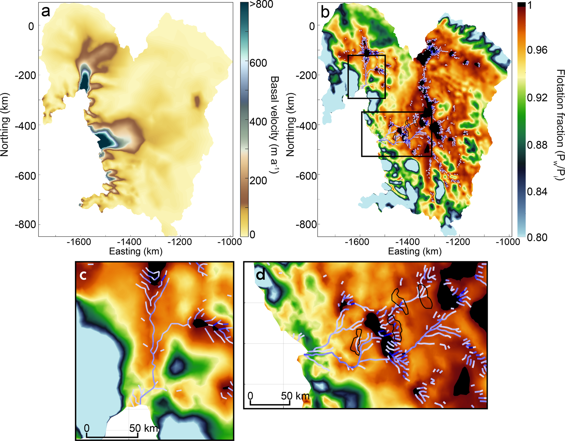
Fig. 2. (a) Basal ice velocity from ISSM inversions. (b) GlaDS model outputs of basal water pressure as a fraction of overburden pressure. The purple lines show the location of subglacial channels. The black boxes outline the locations of panels c and d. (c) Pine Island Glacier water pressure. (d) Thwaites Glacier water pressure, with subglacial lakes outlines from Malczyk and others (Reference Malczyk, Gourmelen, Goldberg, Wuite and Nagler2020) shown in black.
These channels are dendritic in nature, similar to those modelled under the Greenland Ice Sheet (Nienow and others, Reference Nienow, Sole, Slater and Cowton2017). The primary difference between Greenland and Antarctic channels is that the former grow and shrink seasonally and are often lower pressure than the surrounding distributed system. This is due to the constantly changing water input rate (over hourly to diurnal timescales) allowing channel growth more rapidly than can be offset by creep closure. In contrast, the Antarctic channels are nearer to steady state, with changes over longer time periods (monthly to annual timescales), for example as a result of lake drainage (Livingstone and others, Reference Livingstone2022), or alteration in basal velocity (Joughin and others, Reference Joughin, Tulaczyk, Bindschadler and Price2002). Therefore, the Antarctic channels can reach a near-equilibrium where water pressure in the channel is high (in the realm of 98% of overburden; Dow and others (Reference Dow, Ross, Jeofry, Siu and Siegert2022)). This means that, in Greenland, channels are capable of slowing down ice flow by drawing large volumes of water from the surrounding high-pressure distributed system (Nienow and others, Reference Nienow, Sole, Slater and Cowton2017). In Antarctica, the difference in water pressure between channels and the distributed system is smaller, reducing the ability of the channel to remove water from the distributed system and slow ice flow (Dow and others, Reference Dow, Ross, Jeofry, Siu and Siegert2022).
3.3. Effects of water pressure on ice flow
Consistently across the Antarctic GlaDs runs, regions of high ice velocity are associated with high-pressure water (Dow and others, Reference Dow2018c, Reference Dow2020). This is also the case when basal sliding velocities are applied as a spatially-uniform value in order to remove the circularity of including basal velocity in the GlaDS calculations. At Thwaites and Pine Island glaciers, this relationship of high-pressure water correlated with faster ice velocity breaks down in some regions (Figs. 2a and b). Close to the grounding line, the water pressures are not as high (i.e. close to overburden) as at other systems (e.g. Totten Glacier, Dow and others, Reference Dow2020). This may be due to a transition from less efficient to more efficient water drainage near the grounding line as discussed by Schroeder and others (Reference Schroeder, Blankenship and Young2013), who used specularity content data to examine basal hydrological conditions at Thwaites Glacier. Using ISSM to model ice dynamics, McCormack and others (Reference McCormack2022a) found that this region transitions from ice motion dominated by basal sliding to a mixed ice deformation and basal sliding regime. It is in this region where our modelled subglacial water pressure at Thwaites Glacier begins to drop (Fig. 2d), and similar low modelled water pressures near the Pine Island grounding line indicate that a transition to mixed deformation and sliding may also exist there (Fig. 2c). This suggests that, unlike in other areas of the Antarctic, such as the Weddell Sea region (Dow and others, Reference Dow, Ross, Jeofry, Siu and Siegert2022), the channels are efficient enough to remove water from the distributed system, allowing the local water pressure to drop.
Current Antarctic ice-flow rates are strongly controlled by ice-shelf buttressing forces. As ice shelves thin or break up, that buttressing force will lessen and the driving stress of interior ice will increase (Seroussi and others, Reference Seroussi2020). Higher rates of ice flow will have the dual impact of increasing basal melt from friction and also increasing the surface slope and therefore hydraulic potential gradients. Both of these features will further increase the size and efficiency of channels. Near the grounding zone, water will likely begin to accumulate on the ice surface as the air temperature warms over the next century (Trusel and others, Reference Trusel2015; Nowicki and others, Reference Nowicki2020). If this water can hydrofracture through to the ice-bed interface and form moulins, Antarctic ice streams may become more similar to the current seasonally-driven Greenlandic systems where fast ice flow only occurs during part of the year.
3.4. Water flow into ice-shelf cavities
The concentrated flux of freshwater into ice-shelf cavities from channels has been shown to be a key component of ice-shelf melt in the grounding zone (Wei and others, Reference Wei2020; Dow and others, Reference Dow, Ross, Jeofry, Siu and Siegert2022). The freshwater is more buoyant than the ocean water, rises from the grounding line to the ice-shelf base, and can bring deep, relatively warm water with it (Jenkins, Reference Jenkins2011). The most obvious manifestation of this is in the form of basal channels carved into the underside of ice shelves (Le Brocq and others, Reference Le Brocq2013). These can be hundreds of metres in width and depth and are both visible and measurable on the ice-shelf surface due to hydrostatic balancing (Alley and others, Reference Alley, Scambos, Siegfried and Fricker2016). The role of these channels in ice shelf stability is still a question for future research but it has been shown that some are associated with transverse fractures that can lead to calving events (Dow and others, Reference Dow2018b).
There is evidence that, in general, the outflow from subglacial channels is associated with higher melt rates at the grounding zone even in the absence of ice-shelf basal channels (Wei and others, Reference Wei2020; Hager and others, Reference Hager, Hoffman, Price and Schroeder2022; Dow and others, Reference Dow, Ross, Jeofry, Siu and Siegert2022). The grounding zone is a critical area for ice sheet stability where thinning of floating ice could result in grounding line retreat, a particular concern for grounding zones perched at the top of reverse slopes (Reese and others, Reference Reese, Gudmundsson, Levermann and Winkelmann2018). The rates of modelled channelised discharge into the Thwaites and Pine Island ice-shelf cavities (~80 and 40 m3 s−1, respectively) are greater than others modelled using GlaDS and the same ISSM basal melt data product. For example, Totten Glacier and Foundation Ice Stream-Academy Glacier both had modelled channel discharge of ~25 m3 s−1 into the ice-shelf cavity (Dow and others, Reference Dow2020, Reference Dow, Ross, Jeofry, Siu and Siegert2022). The greater subglacial discharge volumes exiting Thwaites and Pine Island Glacier, in addition to the presence of warm circumpolar deep water in these ice-shelf basins (Paolo and others, Reference Paolo, Fricker and Padman2015), suggests that subglacial hydrology outflow may play a crucial role in the grounding zone melt rates, and therefore stability, in these regions.
4. Future outlook of Antarctic hydrology
4.1. Coupled modelling
Currently, most models of subglacial hydrology are run independently of ice dynamics, without accounting for the effects of changing ice sheet geometry on the subglacial system, or using the modelled water pressure to inform ice sheet sliding rates. Progress has been made in Greenland hydrology where GlaDS has been coupled to Elmer/Ice and applied to Store Glacier (Cook and others, Reference Cook, Christoffersen, Todd, Slater and Chauché2020, Reference Cook, Christoffersen and Todd2022). GlaDS has also been written into ISSM and applied to Petermann Glacier (Ehrenfeucht and others, Reference Ehrenfeucht, Morlighem, Rignot, Dow and Mouginot2023). The latter is coupled one-way, in that the effective pressure drives ice dynamics but not the reverse.
The next step for Antarctic subglacial hydrology is to fully couple GlaDS to ice dynamics and run models for both current systems and future scenarios. A coupled modelling approach would be particularly valuable for investigating the impact that seasonal surface-to-bed drainage will have on the basal boundary conditions and ice-flow speed, if moulins begin to form in Antarctica as surface melt increases with warming air temperatures (Trusel and others, Reference Trusel2015). Furthermore, coupling could allow examination of time-transgressive changes to hydrology such as from changes in basal ice velocity (altering the volume of basal melt produced along with cavity opening rates) and ice surface slope.
On the other side of the domain boundary, the impact of subglacial discharge into ocean cavities has only just begun to be explored (Nakayama and others, Reference Nakayama, Cai and Seroussi2021, Pelle and others, Reference T, A, C and J2022). Greenland model runs show that plume outputs from tidewater glaciers can affect circulation in the wider fjord (Slater and others, Reference Slater2018). Analogously, subglacial water discharge could be important for both local and regional melt in Antarctic ice-shelf cavities. In order to project the stability of ice shelves as oceans warm, subglacial discharge outputs must be included in ice-shelf cavity models. Otherwise, calculations of melt, particularly at the critical grounding line may underestimate reality (Dow and others, Reference Dow, Ross, Jeofry, Siu and Siegert2022).
To fully capture the impact of subglacial water flow on the wider system, the ideal approach would involve a fully coupled subglacial hydrology, ice dynamics, and ice/ocean model. Although this sounds complicated, we are not too far from this achieving this approach, as similar applications have occurred in Greenland (Cook and others, Reference Cook, Christoffersen and Todd2022) and begin to be examined in Antarctica, for example at Denman Glacier (Pelle and others, Reference T, A, C and J2022).
4.2. Data collection
Subglacial hydrology models are currently tested against limited in situ or remotely sensed data. There is an urgent need to collect more data in key regions to verify hydrology model outputs.
One major limitation of hydrology models is that basal water inputs rely on geothermal heat estimates applied in inversions of ice dynamics (Seroussi and others, Reference Seroussi2020). However, there is a wide range of geothermal products and even less ability than subglacial hydrology to test which output is the most accurate (Burton-Johnson and others, Reference Burton-Johnson, Dziadek and Martin2020; McCormack and others, Reference McCormack2022b). One option to validate the subglacial hydrology model is to measure grounding line water flux where channels are predicted to exit, and compare with the modelled water volumes. These measurements could be made by AUVs accessing the grounding zone region (Dowdeswell and others, Reference Dowdeswell2008), or by drilling through the ice shelf and installing instrumentation into the cavity where subglacial plumes are predicted to be located. An additional method could involve installing a transect of Autonomous phase-sensitive Radio Echo Sounder (ApRES) instrumentation (Nicholls and others, Reference Nicholls2015) on ice shelves just downstream of channel outlets (perhaps guided by the location of ice-shelf basal channels) in order to model the volumes of channelised discharge that would be required to explain the observed melt rates.
On land, various instrumentation options are available to test hydrology modelling outputs. Combined active seismic and transient elecromagnetic (TEM) instrumentation could allow assessment of the volume of water and its salinity (Killingbeck and others, Reference Killingbeck, Dow and Unsworth2022). This method can also be used to investigate the flow of water upstream into the subglacial system from the ocean due to tidal forcing (Horgan and others, Reference Horgan2013). Drilling directly to the basal system could provide highly pertinent information about the subglacial hydrological system, as has been achieved at Subglacial Lake Mercer (Priscu and others, Reference Priscu2021), and Whillans Ice Stream (formerly known as Ice Stream B) in West Antarctica (Engelhardt and Kamb, Reference Engelhardt and Kamb1997). However, the costs of mounting in situ geophysical and drilling campaigns, and the limited spatial area they can cover suggests that focussed aerial campaigns are also critical for examining subglacial hydrology. For example, the ICECAP project has provided >400 000 km of radar data over Antarctica to date (pers. comm. J. Greenbaum), and the specularity content data derived from those radar lines for Aurora Subglacial Basin proved important for determining the best GlaDS parameters for application in this region (Dow and others, Reference Dow2020). Campaigns guided by modelled hydrology could focus on locating channels and high-pressure distributed systems to validate model outputs.
Subglacial hydrology plays an important role in Antarctic ice dynamics both for land ice and for the stability of ice shelves. Modelling the impacts from subglacial hydrology on ice sheet flow and ice shelf melting are critical areas for predicting the future of the ice sheet and global sea level rise. The development of coupled models accounting for the effects of subglacial hydrology on ice and ocean dynamics should also be complemented by strategically focussed data collection campaigns.
Acknowledgements
Thanks go to Mauro Werder for use of the Glacier Drainage System (GlaDS) model and Mathieu Morlighem for provision of basal ice velocity and melt rates from the Ice Sheet and Sea-Level System (ISSM) model. Funding was provided by the Natural Sciences and Engineering Research Council of Canada (NSERC; RGPIN-03761-2017) and the Canada Research Chairs Program (950-231237). Supercomputing resources were provided by Compute Canada. Thanks also to Sue Cook for suggestions on this manuscript and to Kevin Siu for initial setup of the modelled domain.


 Open access