


Introduction
So far, little attention has been paid to the meteorological records of the few stations located on the eastern side of the Antarctic Peninsula (Fig. 1). in view of the recent major retreat of glaciers and ice shelves in this region (Skvarca, 1993; Rott and others, 1995; Skvarca and others, 1995) and of the sudden collapse of the northern Larsen Ice Shelf (LIS) sections in early 1995 (Rott and others, 1996), it was of interest to analyze the surface air temperatures of the neighbouring stations even though the time series are comparatively short. Since the late 1970s, when Reference MercerMercer (1978) predicted the break-up of the ice shelves on either side of the Antarctic Peninsula as “one of the warning signs that a dangerous warming trend is under way in Antarctica”, two ice shelves have already disintegrated: Wordie Ice Shelf on the west coast (Reference Doake and VaughanDoake and Vaughan, 1991) and more recently the two northernmost sections of the LIS on the east coast. The mountains of the Antarctic Peninsula act as a barrier, resulting in distinct climatic differences between the west coast, with maritime climate modulated by variations in the sea-ice extent of the Bellingshausen Sea, and the east coast, influenced by persistent pack-ice conditions with in the Wcddell Sea in a pseudo-continental, colder climate.
Reference Hoffmann, Nuñez and VargasHoffmann and others (1997) analyzed the climate data of the Orcadas station (ORC; 60°44' S, 44°44' W), located on Laurie Island, South Orkney Islands (Fig. 1), the longest instrumental record available in Antarctica, starting in 1903. They reported an increase of 1.5°C in decadally averaged mean annual temperatures between the periods 1941-50 and 1981-90, rising to 2.1°C if the record is extended back to 1921-30, which has been identified as the period when warming at ORC began. A spatially consistent warming trend of about 2.5°C since 1945 has been reported for the west coast of the Antarctic Peninsula (Reference KingKing, 1994). Vaughan and Doake (1996) confirm the pronounced warming on the west coast, but they explain that “there is little meteorological evidence that warming has also occurred on the cast coast".
To investigate whether the regional trend of atmospheric
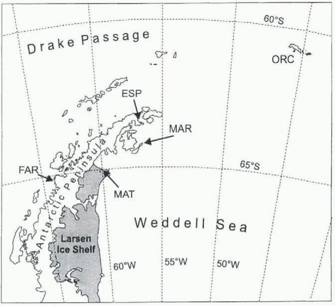
Fig. 1. The region of the Antarctic Peninsula and Weddell Sea, with the locations of the stations. ESP, Esperanza; MAR, Marambio; MAT, Matienzo; ORG, Oreadas.
warming extends also to the east coast of the Antarctic Peninsula, we analyzed the 26 year temperature record of the Marambio station (MAR; 64°14'S, 56°37'W; 198 m a.s.l.) on Seymour Island and the 36 year record of the Esperanza station (ESP; 63°24'S, 57°00'W) located at the northern tip of the peninsula (Fig. 1). in order to learn about the spatial variability, we compared these data with the temperature records of Faraday (FAR; 65°15'S, 64°16' W) and ORG, as well as with summer and winter temperatures of the Matienzo station (MAT; 64°59'S; 60°04' W) on Larsen Nunatak. Information is also provided on the retreat of glaciers and ice shelves in the region of the northeastern Antarctic Peninsula, based on satellite imagery and field observations, in order to show the glacio-logical impacts of the temperature increase.
Sources of Data
Monthly mean temperatures of MAR (October 1970-Fcb-ruary 1997), MAT (January 1962 December 1972 and 1975; summer, with gaps, until February 1985), ESP August 1960-February 1997) and ORG (April 1903-December 1991) were obtained from the database of the Servicio Meteorológico Nacional, Argentina. The temperatures of the Signy station (SIG, January 1947-December 1995) and of FAR (January 1956-February 1997) were obtained from the database oft lie British Antarctic Survey. The FAR data from 1996 onwards are from the Ukrainian station Vernadsky which is the successor of the Faraday station located at the same site. SIG is located on Signy Island, South Orkney Islands, near ORG The correlation coefficient R of the annual mean temperatures between ORG and SIG is 0.97. Homogeneity of ESP and MAR data was tested by bivariate tests (Reference PotterPotter, 1981), assuming ORG and SIG to be homogeneous series. According to these tests, the temperature series of these two stations can be assumed to be homogeneous. Missing monthly mean temperatures of MAR and ESP were supplement ed by means of monthly regression between the two stations which are well correlated (table 2).
Temporal and Spatial Variability of Annual Air Temperatures
Annual mean temperatures Ts for the records ORG, ESP and MAR are shown in Figure 2, together with edge-truncated, floating averages over 9 years to enhance the trends. After a decrease in the 1920s, the temperature series of ORG shows a trend of increasing TA from 1930 to 1960 and from the mid-1970s to the present. Clear trends of increasing ΓΑ are also evident for the shorter periods available for ESP and MAR. According to the Kendall-Mann test (Sneyers, 1990), the trends are significant at the 95% level for the time series of ORG since 1930. For ESP and MAR the trends are significant at 95% only for the summer temperature series. For the other seasons and the annual temperatures, the trends, though clearly apparent, are below this level of significance because of higher interannual variability and the shortness of the time series. in order to enable theintercom-parison of the different stations, we calculated standard deviations and the linear trends for various periods by means of least-squares fits (table 1).
The analysis for the different stations indicates a spatial pattern of increasing warming from the South Orkney

Fig. 2. Time series of annual mean temperatures at (a) ORC, (b) EST and MAR. A different time-scale is usedfor ORC. Dashed line: edge-truncated 9 year floating mean.
Table 1. Characteristics if annual mean temperature series for various periods
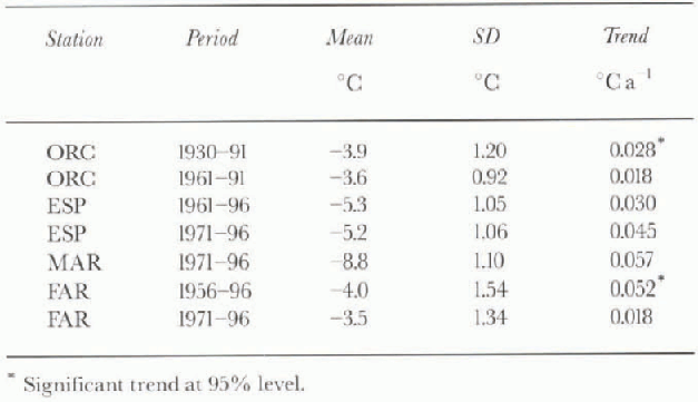
Islands towards the Antarctic Peninsula. The magnitude of the linear trend of MAR for the period 1971-96 (0.057°Ca−1) is similar to that of FAR for the period 1946-90 (0.056 C a−1) reported by King (1994), and for the period 1956-96 (0.052° Ca−1) based on the data we have available. However, for the shorter period 1971-96 the warming trend at FAR is much less pronounced. The reason is that 1970-75 was the warmest period of the complete FAR record, whereas the average of these 6 years was below the average of the last 30 years at ESP, MAR and ORG, as well as at the Chilean station O'Higgins situated on the west coast between ESP and FAR. However, other patterns of the temperature scries on the western and eastern coasts are in agreement. Thus, 1989 has been the warmest year with in the investigation period at FAR, as well as at MAR, ESP and ORC, and the trend of above-average temperatures in the 1990s has been observed at all stations. The decade 1981 -90 was the warmest at all of these stations. in addition, the recent ice-core analyses from the Dyer Plateau reveal that the past two decades figure among the warmest since AD 1510 (Reference ThompsonThompson and others, 1994).
The trend analysis suggests that the regional atmospheric warming of recent decades has affected both the eastern and western sides of the Peninsula, though the year-to-year intercomparison shows considerable differences. The standard deviation of TA in Table 1 suggests that the interannual variability is some what higher on the western side of the Peninsula. This extreme climate sensitivity of the western side has been explained by coupling between temperature and sea-ice extent in the Bellingshausen Sea (King, 1994). in the western Wcddcll Sea the sea ice is more persistent throughout the year (Reference Gloersen, Campbell, Cavalieri, Comiso, Parkinson and ZwallyGloersen and others, 1992).
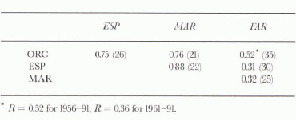
The mean annual temperatures show a close correlation between MAR and ESP (table 2). Years with more than one month supplemented by regression from another station were not considered for the correlation. The close correlation with MAR suggests that ESP, though located at the northern tip of the Peninsula, is not only affected by the west wind regime of the Drake Passage, but also shows strong links with the weather of the Weddell Sea. in spile of the somewhat larger distance, the correlation of ESP and MAR with ORC is clearly higher than the correlation of these stations with FAR. The spatial pattern of correlations is in agreement with the analysis of pressure variations by King (1994) who found a strong meridional component of pressure variations with opposite signs between the Bellingshausen Sea and the northwestern Weddell Sea. The lower correlation between ORC and FAR for the shorter time period is due to the larger weight of the unusually warm years 1970-75 at FAR which also strongly reduce the correlations with ESP and MAR.
Table 2. Correlation coefficients between the annual mean temperatures (in parentheses number of years)
Trends of Summer and Winter Temperatures
The most drastic ice retreat on the northern part of the Antarctic Peninsula was observed on the LIS. MAT is located on Larsen Nunatak on the northern section of LIS. Annual meteorological observations are available for MATonly for the years 1962-72, and summer temperatures, though with some gaps, until 1985. For studying the ice-shelf retreat, meteorological data are of particular importance. For this reason we investigated the relations between MAT and the neighbouring stations MAR and ESP. The mean temperatures of MAT and ESP differ by 2.9°C in summer and as much as 10°C in winter. During the 28 months of parallel observations, the average summer temperatures of MAT and MAR differed only by 0.1°C, with a correlation coefficient R = 0.90, which indicates that the summer temperatures of MAR are well suited for describing the summer conditions on the northern LIS.
The mean winter temperatures of MAT were lower by 5.1°C than corresponding temperatures of MAR, as determined from the short overlapping observation period. The seasonal differences result from the local orography. MAT is located close to sea level, at the foot of a small nunatak which, prior to the collapse in 1995, was 20 km from the ice edge. Because the station has been surrounded by an ice shelf, in winter it was frequently within strong temperature inversions, as the meteorological observations show. in summer the atmosphere is much better mixed. MAR is located on the top of a meseta at 198ma.s.l. on a small island, and for this reason usually stands above the surface inversion which sometimes develops during winter over the surrounding ice-covered sea.
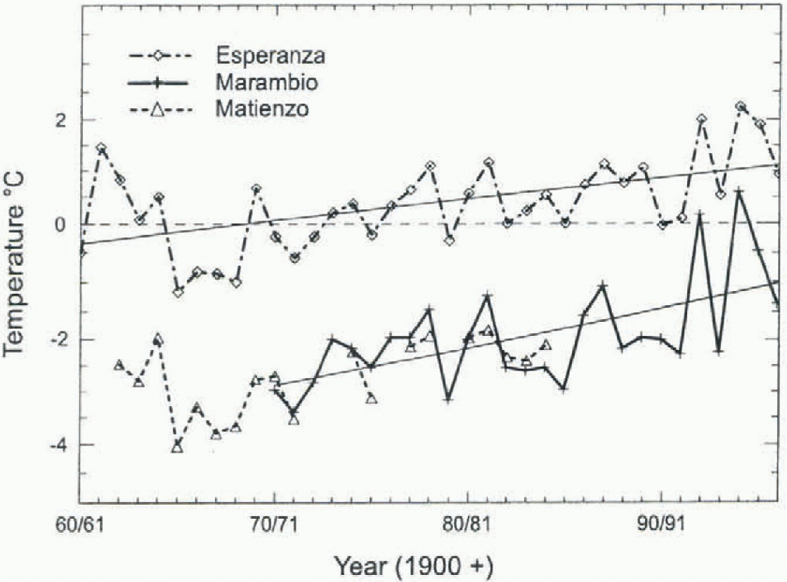
Fig. 3. Summer mean temperatures at ESP, MAR and MAT. The lines show the least-squares fits for ESP and MAR.
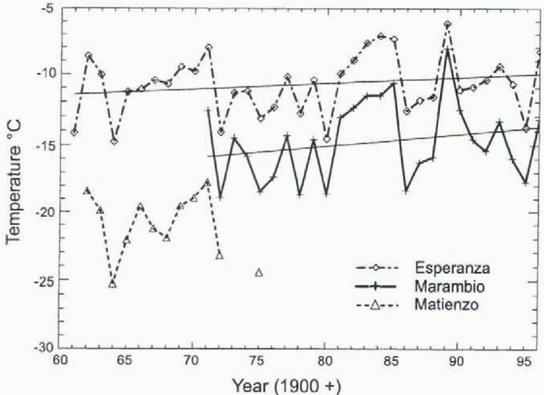
Fig. 4. Winter mean temperatures at ESP, MAR and MAT. The lines show the least-squaresfits for ESP and MAR.

Fig. 5. Left: Landsat MSS image mosaic from J March 1986 with ice-shelf boundary on 26 August 1993 (white) and 8 March 1995 (black). Right: ERS-2 SAR image mosaicfrom 17 November 1996. Dashed line in the MSS image shows the boundary of this mosaic. JP, Jason Peninsula: JRI, James Ross Island: LI, Larsen Inlet; PG, Prince Gustav Channel; RI, Robertson Island; SN, Seal Nunataks; SP, Sobral Peninsula.
Figure 3 shows the time series of summer temperatures, and Figure 4 of winter temperatures, at ESP and MAR. The least-squares fits have been calculated for the data of these two stations. For comparison the summer and winter temperatures of MAT are also shown. The summer temperatures of MAR and ESP indicate a pronounced warming trend which is significant at the 95% level according to the Kendall Mann test. According to the linear fit, the increase was 0.075°Ca for summer temperatures between 1970-71 and 1996-97 at MAR, and 0.041 °C a−1 for summer temperatures between 1960-61 and 1996-97 at ESP. The temperature increase during winter was slightly larger at MAR (0.083°Ca−1) and similar at ESP (0.043 Ca−1), but according to the Kendall-Mann test the statistical significance is lower in winter due to the larger interannual variability.
Retreat of Glaciers and Ice Shelves Associated with Atmospheric Warming
The trend of atmospheric warming coincides with the retreat of the northern LIS. During the last two decades, most of the tidewater glaciers onjames Ross Island have also retreated, as monitored by means of satellite imagery since 1975 (Skvarca and others, 1995). On LIS a constant retreat of the ice front north of Robertson Island has been reported for the period since the 1940s (Doake, 1982). The ice shelf in Prince Gustav Channel was separated from the main part of LIS in 1957 or 1958. After 1986 the retreat accelerated, as illustrated in Figure 5 showing a Landsat multispcctral scanner (MSS) image mosaic from I March 1986 and a European Remote-sensing Satellite (ERS-2) synthetic apcrturc radar (SAR) image mosaic from 17 November 1996. During this period, the ice-shelf area north ofjason Peninsula decreased from 16 220 km2 to 10 615 km2. One major event during the retreat was the break-up of the Larsen Inlet (north of Sobral Peninsula) during the period 1987-89 (Skvarca, 1993) with warm summers in 1986 87 and 1987-88. Another major retreat was observed in the summer of 1992-93 when the ice shelf between Sobral Peninsula and Seal Nunataks decreased by 209 km2 within a few weeks (Rott and others, 1995). During 1992-93 the mean summer temperature at MAR exceeded 0°C for the first time.
The summer 1994-95 was the warmest ever recorded at MAR, with a mean temperature of +0.6°C. The main retreat of northern LIS happened in January 1995, when the ice-shelf section in Prince Gustav Channel and the section between Sobral Peninsula and Seal Nunataks disintegrated almost completely within a few days, and a large iceberg broke off from the section between Seal Nunataks and Jason Peninsula. The total decrease in area due to these events was 4200 km2 (Rott and others, 1996). According to considerations on surface mass balance and ice dynamics, the summer conditions are of particular importance for the stability or retreat of an ice shelf which is located in a region of extensive summer melt. The infiltration of melt-water in crevasses accelerates the fracturing and certainly played an important role in the final disintegration process in 1995 which happened during a period of high air temperatures and strong northwesterly winds. Field observations in October and November 1996 and the analysis of satellite data show that the fracturing process in the ice-shelf section between Seal Nunataks and Sobral Peninsula intensified during the previous two summers (Rott and others, 1998). This indicates that the ice-shelf retreat will spread further south if the atmospheric warming trend continues.
Conclusions
The meteorological observations at the MAR and ESP stations were analyzed and compared with those of FAR and with two stations on the South Orkney Islands. The analysis clearly confirms that the recent trend of regional atmospheric warming also affected the eastern Antarctic Peninsula. The temporal sequence of warming differs between stations in the east and those in the west, the main differences being during the period 1970-75 which was the warmest period at PAR. The observed retreat and collapse of the northern parts of LIS and of tidewater glaciers on James Ross Island are in agreement with this climatic trend. of particular importance for the mass balance and dynamics of the floating ice are the summer temperatures, which showed a statistically significant increase during the observational period in MAR and ESP.
Acknowledgements
The temperature data were provided by Servicio Meteorológico Nacional, Fuerza Aerea Argentina, and by the British Antarctic Survey. The ERS-2 SAR images were made available by the European Space Agency for ERS Experiment AO2.A101. This work is a contribution to the Larsen Ice Shelf Project of Instituto Antàrtico Argentino, Dirección Nacional del Antàrtico, and to Austrian Science Fund (FWF) project No. 10709-GEO.


