


Introduction
The magnitude of climate warmth in Antarctica during the early–mid Pliocene and the associated size of the Antarctic ice sheet are fundamental questions about the causes and impacts of Pliocene global warmth (Reference Chinn and WoodsCronin and others, 2005; Reference Denton, Sugden, Marchant, Hall and WilchDowsett and others, 2005). The Antarctic glacier–climate system’s response to past warming also provides important insight into how future warmer global air temperatures might influence the Antarctic environment. The common wisdom from the McMurdo Dry Valleys (MDV) of Antarctica is that during the early–mid Pliocene, Antarctica was no warmer than it is now and ice volume was about the same (Reference Dana, Wharton and FountainDenton and others, 1993; Reference Prentice and KrusicSugden and others, 1995; Reference Kuhn and J.Lewis and others, 2006). Evidence for this ‘stable’ view is the presence of Miocene-age volcanic ashes interpreted to be in situ (Reference KurowskiMarchant and others, 1996) and still hardly modified by glacier overriding. However, conditions warmer than present in the McMurdo Sound region in the early–mid Pliocene have been inferred from the oxygen isotopic composition of foraminifers and scallops in fjord deposits in the MDV, indicating fresher and warmer (0–3°C) fjord bottom water than water in the Ross Sea today (Prentice and others, 1993). Moreover, the fossil content of sediments from several sectors of coastal Antarctica (e.g. Nothofagus wood, beetles, and shells) has been interpreted as evidence for a possible warming of 20°C relative to modern in the early Pliocene (Reference Prentice, Kennett and WarnkeWebb and other, 1984; Reference Ashworth and KuschelAshworth and Kuschel, 2003). The mountains of the MDV contain many alpine glaciers whose fluctuations since the late Miocene are documented on the ice-free slopes of the trunk valleys. Here we reconstruct the early–mid Pliocene equilibrium-line altitudes (ELAs) of four alpine glaciers (Fig. 1) and compare these values to modern ELAs.
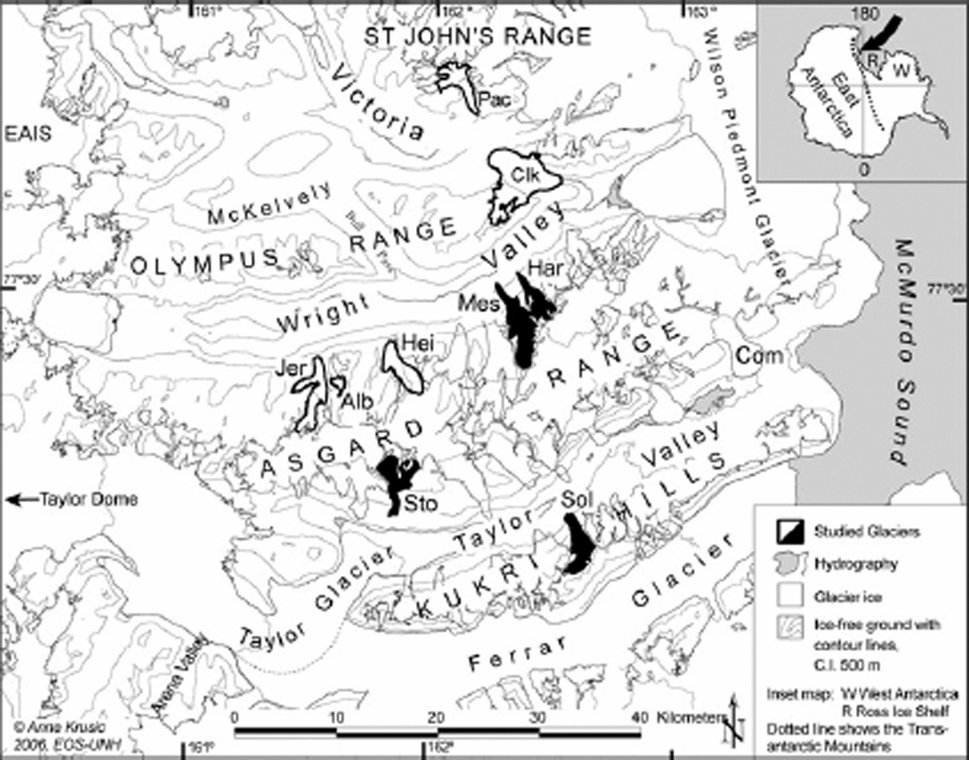
Fig. 1. The McMurdo Dry Valleys, Antarctica. Reconstructed alpine glaciers (black) are: Meserve (Mes), Hart (Har), Stocking (Sto) and Sollas (Sol) glaciers. Mass-balance measurements were available for the following glaciers: Packard (Pac), Clark (Clk), Jeremy Sykes (Jer), Alberich (Alb), Heimdall (Hei) and Meserve (Mes) glaciers. Modern ELA from Commonwealth Glacier (Com) in Taylor Valley is included in Figure 2. The East Antarctic ice sheet is denoted EAIS. C.I.: contour interval.
Alpine glacial deposits of Pleistocene age in both Wright and Taylor Valleys are narrow boulder-belt moraines (Reference Fountain, Nylen, MacClune and DanaHall and others, 1993; Reference SugdenWilch and others, 1993a; Prentice and Krusic, 2005). However, in the early-mid Pliocene, alpine glaciers were at times substantially advanced compared to today. The oldest glacial deposits that can be reached by hand-dug excavation dated to >3.7±0.1Ma (Reference Fountain, Nylen, MacClune and DanaHall and others, 1993) and occur beyond the boulder belts (Prentice and Krusic, 2005). Maintenance of lower and larger alpine glaciers in the MDV required a different climate, most likely an increase in precipitation. Higher Pliocene precipitation totals are plausible only if accompanied by higher temperatures, which would have supported more atmospheric moisture. Therefore, our hypothesis is that the early–mid Pliocene ELA was lower than the modern ELA, indicative of a warmer and wetter climate in the early–mid Pliocene than the present.
The alpine glaciers in the MDV are polar, meaning they are cold-based year round and in equilibrium with the polar desert climate (Reference Hall, Denton, Lux and BockheimHoldsworth and Bull, 1970; Reference ChinnChinn, 1991). Mean annual temperature at sea level ranges between –15 and –20°C, and mean annual precipitation is <100mmw.e. (Reference ChinnChinn, 1991; Reference Fountain, Dana, Lewis, Vaughn, McKnight and PriscuFountain and others, 1999). Glacier ablation is dominated by sublimation (Reference ChinnChinn, 1994; Reference Dowsett, Chandler, Cronin and DwyerFountain and others, 1998). The accumulation-area ratio (AAR), a predefined ratio of the glacier’s area of positive net annual mass balance, was calculated by Reference ChinnChinn (1994) to be 0–0.4 for the polar glaciers in the MDV, a ratio that reflects the low ablation rate (Reference Meier and TangbornPorter, 1975).
Moisture is mainly from the Ross Sea and is limited by low air temperature (Reference Denton, Bockheim, Wilson and StuiverDort, 1970; Reference ChinnChinn, 1996; Reference Dowsett, Chandler, Cronin and DwyerFountain and others, 1998). Orographic barriers influence the distribution of precipitation, and glacier accumulation is dominated by redistributed wind-blown snow (Reference ChinnChinn, 1996; Reference DortFountain, 1996, Reference Dowsett, Chandler, Cronin and Dwyer1998). During the most recent glacial maximum in the region, grounded ice in the Ross Sea lowered precipitation reaching the MDV, causing the climate in the valleys to be much drier and cooler than today (Reference CuffeyDenton and others, 1989). Consequently, alpine glaciers, as well as Taylor Glacier (a valley glacier), were smaller and ELAs were assumed higher than today (Reference CuffeyDenton and others, 1989).
We selected four alpine glaciers, two in Wright Valley and two in Taylor Valley, with extensive early–mid Pliocene moraine sequences for paleo-ELA reconstruction (Fig. 1) (Reference Ishman, Reick, Kennett and BarronKrusic, 2006). For these glaciers, modern and early–mid Pliocene ELA was estimated to assess the ELA difference, ΔELA, between these times. Modern mass-balance measurements are available for one of the reconstructed glaciers, Meserve Glacier, and for five other glaciers in Wright and Victoria Valleys (Fig. 1). The mass-balance data include specific summer and winter balance values collected over mass-balance seasons (1972/73 to 1982/83, with data from one to four glaciers per season) (Reference ChinnChinn, 1979, Reference Chinn1980, Reference Chinn1981, Reference Chinn1983).
Methods
Early–mid Pliocene glacier reconstruction
The early–mid Pliocene glacier margins were reconstructed by following center lines and crests of lateral moraines interpreted as belonging to the oldest alpine glaciations (Reference Fountain, Nylen, MacClune and DanaHall and others, 1993, Reference Furbish and Andrews1997; Prentice and Krusic, 2005), representing maximum possible early–mid Pliocene glaciers. Above the elevation of the highest alpine deposits, the boundaries were identified by break-of-slopes in the bedrock interpreted from aerial photographs and topographical profiling in ArcGIS. We adjusted the margins to be symmetrical where laterally supporting landforms were missing.
The glacier-margin elevations were estimated from moraine-crest elevations obtained by lidar and trimlines interpreted from inflections in the bedrock topography (Reference Ishman, Reick, Kennett and BarronKrusic, 2006). Contour lines with 100m intervals were interpolated over the paleo-glacier surface, drawn in straight lines to avoid bias of the ELA position. The largest source of error in the reconstructed hypsometry was estimated to be in the accumulation area where the early–mid Pliocene glacier surface elevation was approximated. In the ablation zone, the error in reconstructed surface elevation originates in the use of the modern height/width ratio, but we assume this error is less significant due to the defining surficial geology. We assume that the larger Meserve, Hart and Stocking glaciers did not merge with any other glaciers.
Modern mass balance and ELA
The modern ELA (ELAbn) was calculated for the six glaciers by digitizing point mass-balance measurements into a Geographic Information System (GIS) and contouring the data. We then calculated the modern ELA through interpolation of the B n–elevation pairs just below and above B n = 0. Modern mass-balance data were used to calculate balance ratio (BR, the ratio between the ablation gradient and the accumulation gradient) and AAR. The BR is averaged to obtain a regional value for the reconstruction of early–mid Pliocene ELA for the other three glaciers (Hart, Sollas and Stocking glaciers).
Early–mid Pliocene ELA estimation
We calculated early–mid Pliocene ELA with the area–altitude balance ratio (AABR) method and maximum elevations of lateral moraines (MELM) (Reference AndrewsAndrews, 1975; Reference Fountain, Lewis and DoranFurbish and Andrews, 1984; Reference Holdsworth and BullKaser and Osmaston, 2002). First introduced by Reference KrusicKurowski (1891) and later developed by Reference Marchant, Denton, Swisher and PotterOsmaston (1975) and others (Reference Fountain, Lewis and DoranFurbish and Andrews, 1984; Reference Holdsworth and BullKaser and Osmaston, 2002), the AABR method takes into account glacier hypsometry and shape of the mass-balance gradient. This gradient is defined as the change of the net specific mass balance (b n) with altitude. The AABR method assumes glacier equilibrium, linear ablation and accumulation mass-balance gradients (mass balance vs altitude). We further assume that the AABR method is applicable in both the modern and the early–mid Pliocene environment and that the laws of glacier dynamics are the same. We estimate that the uncertainties of the hypsometry, especially glacier surface elevation, give an ELA error of ±150 m. To assess the accuracy of the AABR method itself, we recalculate the modern ELA and compare it to the ELAbn. Because the AABR method is sensitive to hypsometry, we use a 100m contour interval for both the modern calculations and the reconstructed early–mid Pliocene alpine glacier topography with this method.
The ELA reconstructed from the AABR method depends on BR (Reference Fountain, Lewis and DoranFurbish and Andrews, 1984; Reference Holdsworth and BullKaser and Osmaston, 2002). Changes in BR over time are interpreted to reflect glacier response to climate changes (e.g. Reference Kaser and OsmastonKuhn, 1989), and BR is an established measure of the glacier–climate relationship. Typical BR values are 1.8–2.2 for glaciers in Alaska and Washington states (Reference Lewis, Marchant, Kowalewski, Baldwin and WebbMeier and Tangborn, 1965; Reference Fountain, Lewis and DoranFurbish and Andrews, 1984), whereas BR values of 3–25 have been calculated for tropical glaciers (Reference Fountain, Lewis and DoranFurbish and Andrews, 1984; Reference Holdsworth and BullKaser and Osmaston, 2002). In this study, we used the average maritime mid-latitude glacier BR value of 2.0 as a warm end-member and the present-day BR value as a cold end-member, bracketing the possible early–mid Pliocene ELA range. For each glacier we average the results from two early–mid Pliocene ELA calculations: a maximum early–mid Pliocene ELABR=1.1 using the current polar glacier BR = 1.1; and a minimum ELABR=2.0. The MELM method yields an ELA based on the elevation of lateral moraines and thus provides a minimum measure for the early–mid Pliocene ELA (Reference AndrewsAndrews, 1975).
Results
Modern (1979–86) ELA based on mass-balance data
ELAs for the five alpine glaciers in Wright Valley based on mass-balance measurements (e.g. Reference ChinnChinn, 1979, Reference Chinn1980, Reference Chinn1981, Reference Chinn1983) range between 795 and 1591 ma.s.l. (Table 1) and rise with increasing distance from McMurdo Sound (Fig. 2). The ELA gradient parallel to the floor of Wright Valley is 24 mkm–1, only slightly lower than the gradient of 29mkm–1 that Reference Fountain, Dana, Lewis, Vaughn, McKnight and PriscuFountain and others (1999) computed for Wright Valley.
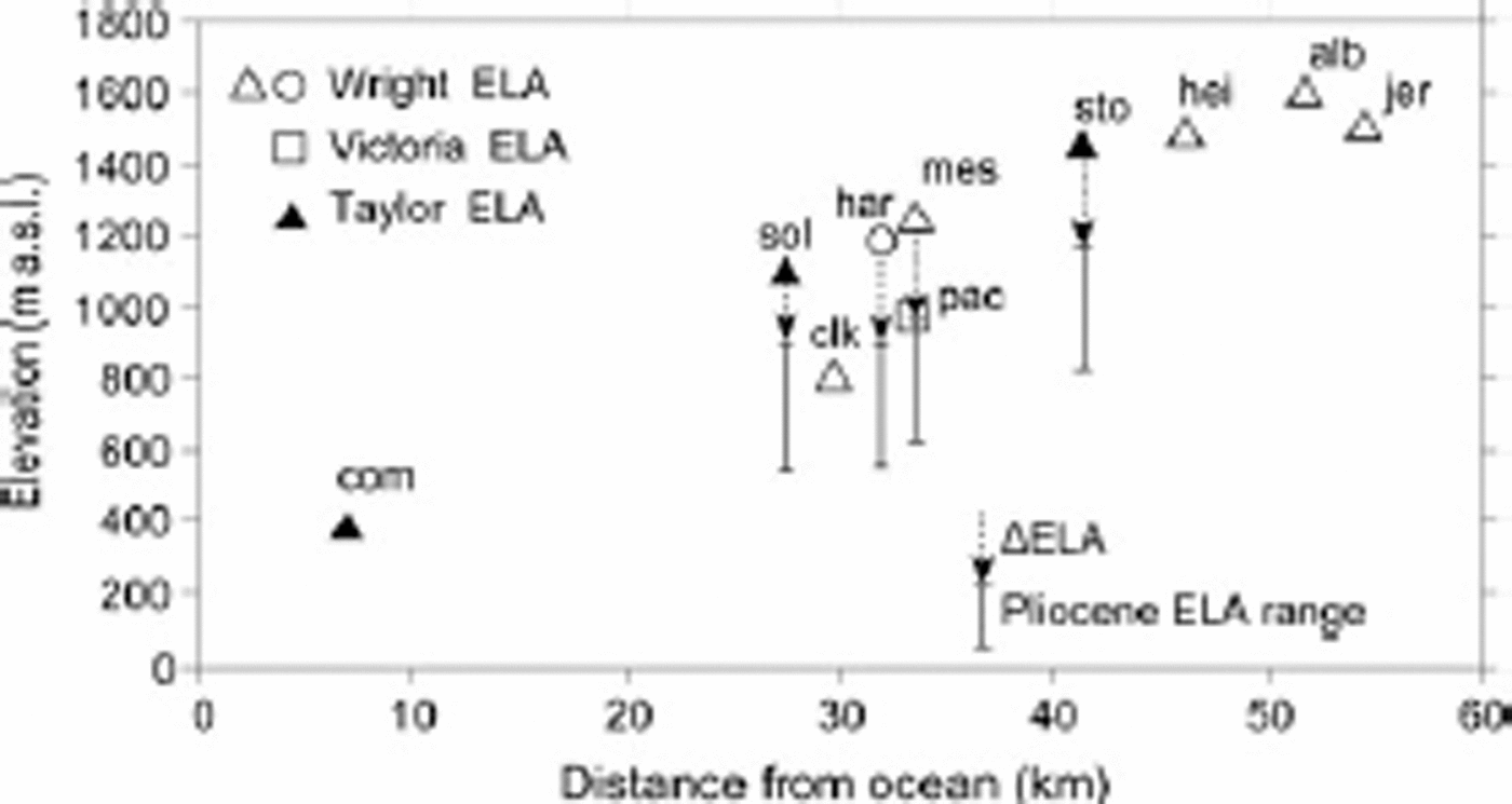
Fig. 2. Average modern and estimated early–mid Pliocene ELAs of selected Wright and Victoria Valleys (open symbols) and Taylor Valley alpine glaciers (filled symbols) with distance from the Ross Sea. Modern ELAs are based on mass-balance measurements except for Hart (har; open circle), Sollas (sol) and Stocking Glaciers (sto), which were estimated from BR = 1.1. Commonwealth Glacier (com) ELA data are from Reference Fountain, Dana, Lewis, Vaughn, McKnight and PriscuFountain and others (1999). Other glaciers in Wright Valley are: Clark (clk), Meserve (mes), Heimdall (hei), Alberich (alb) and Jeremy Sykes (jer). Packard Glacier (pac) in Victoria Valley is also included. Early–mid Pliocene ELAs are presented as a range adjusted for 150 m uplift (top) and 500 m uplift (bottom).
Table 1. ELA and average AAR and BR calculated from the 1970–1980 mass-balance data in the MDV. The last columns show estimated ELA and deviations from actual ELA b n based on the average BR value
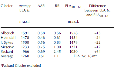
BR values range between 0.56 and 2.45. The high BR (2.45) of Packard Glacier deviates from that of the Wright Valley glaciers. It reflects a much lower ELA which might be the result of temporary local ablation (e.g. from wind erosion, or from different climatic conditions in eastern Victoria Valley). The average BR is 1.1, or 0.94 without the Packard Glacier ELA. The average value for AAR is 0.61 (Table 1), higher than the AAR of 0–0.40 that Reference ChinnChinn (1994) proposed. The average modern ELA for the selected MDV glaciers is 1260ma.s.l. (Table 1).
Early–mid Pliocene glacier reconstruction
The four alpine glaciers, Meserve, Hart, Solla, and Stocking, were all longer and had wider snouts at their maximum positions in the early–mid Pliocene than at present. The front of Meserve Glacier, at its maximum in the early–mid Pliocene, was situated at 200ma.s.l., almost 1.2 km down-slope from the present glacier front (Fig. 3). The glacier was also ∽1 km wider than at present, and its total area was over twice as large as today. The maximum area of Hart Glacier in the early–mid Pliocene was 30% larger than today and had a frontal position at 225 ma.s.l., 900 m from the present glacier front (Fig. 3). Sollas Glacier at early–mid Pliocene maximum was nearly double the size of the present glacier. The snout was 50m lower and 600m advanced relative to today (Fig. 3). Both Hart and Sollas Glaciers were wider higher up-glacier due to the gentle lateral rock slopes. Stocking Glacier early–mid Pliocene glacier terminus was 1 km from the present terminus and ∽100m lower (Fig. 3), and the glacier was larger by >60% than today.
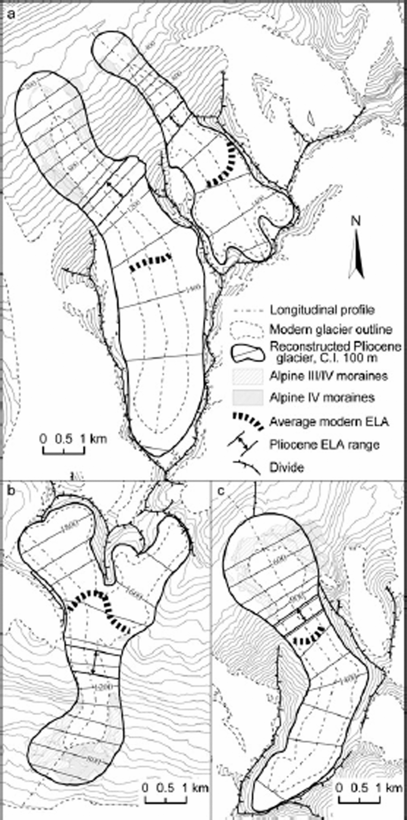
Fig. 3. Maximum extent of Meserve and Hart Glaciers, (a) Stocking Glacier (b) and Sollas Glacier (c) in the early–mid Pliocene during the Alpine IV glaciation. Reconstructed hypsometry is shown with a contour interval of 100m and land topography with 50 m. The range of early–mid Pliocene ELAs is shown with double arrow. C.I: contour interval
Early–mid Pliocene ELA
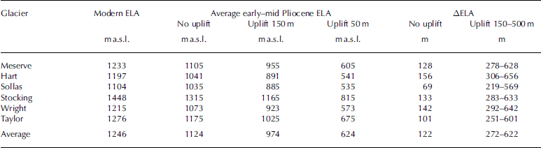
The average early–mid Pliocene ELABR for Meserve, Hart, Sollas and Stocking glaciers was 1124±170ma.s.l. (Table 2). The error is the sum of the ±18m from the AABR method and the estimated ±150m from uncertainties in paleo-glacier hypsometry. Early–mid Pliocene AARs average 0.64 (from ELABR=1.1) and 0.71 (from ELABR=2.0). The ELA change, ΔELA, between the early–mid Pliocene and today, as the difference between the early–mid Pliocene BR-derived ELA and the observed modern ELA, is 120 m (Table 3).
Table 2. Modern ELA for selected MDV glaciers, and ELA during their early–mid Pliocene glacial maximum, estimated with the MELM and AABR methods. Average ELA and error estimate is for the best-estimate early–mid Pliocene ELABR. All elevations are ma.s.l.
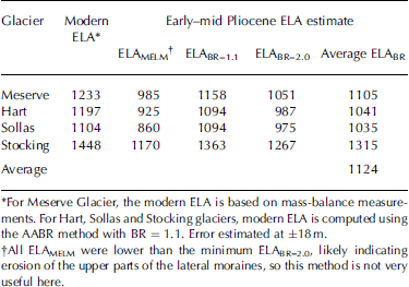
Table 3. Modern ELA and ELA during early–mid Pliocene alpine glacial maximum for selected glaciers in the Dry Valleys and the ΔELA between these two times. The early–mid Pliocene ELAs are based on the AABR method (no uplift), and adjusted for uplift scenarios of 150 and 500m
Interpretation and Discussion
Modern mass balance and ELA in the MDV
ELAs are complex and vary widely across the valleys because of strong winds, irregular topography and very low precipitation. The accumulation patterns coincide with lee sites under mountain flanks and arêtes in response to prevailing southwest winds bringing precipitation or redistributing snow. Ablation is low and mainly reflects sublimation; wind erosion also plays a role. The Wright Valley mass-balance data show that one single storm event can be significant for mass balance, a sensitivity that Reference Fountain, Lewis and DoranFountain and others (2006) also found in Taylor Valley. The higher inland ELAs reflect warmer, drier conditions resulting from geographic blocking of maritime air.
Tectonic uplift since the early–mid Pliocene
The reconstructed ELAs should be adjusted for tectonic uplift since the early–mid Pliocene. Reference Hall, Denton, Lux and SchluchterIshman and Rieck (1992) suggested an uplift rate of 125 mMa–1, which implies total uplift since 4Ma of 500 m. Reference SugdenWilch and others (1993a) concluded that uplift was <300 m, with the possibility that there has been no uplift since the early–mid Pliocene. However, elevated early Pliocene marine sediments in the MDV show that uplift has occurred since the Pliocene (e.g. Reference OsmastonPrentice and others, 1993). Therefore, the early–mid Pliocene ELAs were adjusted for two different uplift scenarios: a moderate uplift scenario represented by an average uplift of 150m (Reference Webb, Harwood, McKelvey, Mercer and StottWilch and others, 1993b); and a maximum uplift scenario of 500m (Reference Hall, Denton, Lux and SchluchterIshman and Rieck, 1992). With adjustments for uplift, the average ΔELA since the early–mid Pliocene was 270–620±170m (Table 3).
Early-mid Pliocene glaciers and climate inference
One issue is the subglacial thermal regime. Early-mid Pliocene moraines are significantly larger than the late Pleistocene and Holocene boulder-belt moraines. The glacial sediments in hand-dug pits are coarse in texture, lack striated stones and contain ventifacts, and thus led Reference Fountain, Nylen, MacClune and DanaHall and others (1993) to infer that glaciers were as polar as today and that there has been a continuously cold climate. Because the current sediment volumes are tiny, this seems implausible. Reference PorterPrentice and Krusic (2005) argued that the environment in the MDV must have been significantly different in the past to support much-expanded alpine glaciers. Although Reference Cronin, Dowsett, Dwyer, Baker and ChandlerCuffey (2000) demonstrated subglacial debris entrainment at a frozen glacier bed, this mechanism erodes and moves only small sediment volumes. Though it is not known how long it took for the early–mid Pliocene moraines to be deposited, it is possible that some of the sediments were derived subglacially from a partially thawed glacier bed. As microfossils have shown warmer sea surface temperatures, it is feasible that, for example, summer air temperatures were high enough to enable melting and glacier sliding. The climate-change mechanisms responsible for these observations would most likely involve a decrease in sublimation, and an increase in melting and accumulation. The combination of evidence of much larger early–mid Pliocene glaciers, possibly larger moraine sediment volumes, and lower early–mid Pliocene ELA than today, supports a warmer and wetter Pliocene climate. We suggest that it is possible that some of the alpine glaciers were partly wet-based in this warmer and wetter early–mid Pliocene environment.
Conclusions
In Wright Valley, present-day ELAs based on mass-balance data increase with inland distance, and averaged 795 ma.s.l. (Clark Glacier), 1233 ma.s.l. (Meserve), 1478 ma.s.l. (Heimdall), 1591 ma.s.l. (Alberich) and 1500ma.s.l. (Jeremy Sykes). For the above-mentioned glaciers and time, the AAR averaged 0.61 and the BR averaged 1.1.
ELAs have risen from the early–mid Pliocene to the cold and dry conditions of the present MDV by 120 m. Considering uplift, the ΔELA may have been 270– 620±170 m. Uncertainties are a combination of the glacier reconstruction, where the lack of surficial geology and erosional marks in the accumulation area makes the drawing of the early–mid Pliocene glacier boundary interpretative and subjective; and within the assumption that ELA reconstructions based on parameters derived under current climate conditions are applicable in the early–mid Pliocene. We suggest that the early–mid Pliocene climate in the McMurdo Dry Valleys was warmer and wetter than previous studies of alpine glacier geology have stated.
Acknowledgements
We thank T. Chinn, the Scientific Editor, and K. MacClune for helpful editorial comments. The US National Science Foundation, under grant No. OPP96-27625, partially supported this research. We thank S. Glidden, M. Routhier, T. Brackett and N. Torbick for expert GIS support. The material was included in a thesis submitted to the Graduate School at the University of New Hampshire as part of the requirements for completion of a master’s degree.


