


Since at least 1997, archaeologists have been conducting ethnographies and archaeological surveys of human-occupied interactive digital built environments—namely, virtual worlds and video games. These archaeologists investigate the possibility of using evidence produced by players in digital worlds for archaeological and anthropological research regarding human behavior in physical spaces (Aycock and Biittner Reference Aycock and Biittner2020; Boellstorff et al. Reference Boellstorff, Nardi, Pearce and Taylor2012; Jones Reference Jones1997; Reinhard Reference Reinhard2018, Reference Reinhard2019; Smith Nicholls and Cook Reference Smith Nicholls and Cook2022). Such studies have shown how the investigation of these landscapes both observe and record ephemeral traces left by players on them. This ephemera can be interpreted as archaeological evidence of digital occupation and community. Moreover, archaeologists can potentially interview human players regarding the reasons behind their behavior, thereby filling the gap between archaeological record and agency. According to Aycock, “Archaeology has sought to understand humans through their material culture. . . . Much of modern culture is expressed in digital form, and this trend is increasing” (Reference Aycock2021:1584). Therefore, it is crucial to develop a methodology to collect and analyze the artifacts of the digital world. Archaeologists of traditional contexts increasingly struggle with the size of datasets collected in archaeological settings, because such datasets are often incomplete due to the poor availability and preservation of the archaeological record.
Datasets from digital environments (e.g., video games), however, are potentially illimited in their ethnographic applications. Going beyond ethnography, archaeologists have also used digital games and virtual worlds for archaeological reconstruction based on an archaeological investigation and excavation (e.g., Edwards et al. Reference Edwards, Griffiths, Reynolds, Stanford and Woods2021; Morgan Reference Morgan2009; Politopoulos et al. Reference Politopoulos, Ariese, Mol and Boom2019) and for agent-based modeling (ABM; Graham Reference Graham, Mol, Ariese-Vandemeulebroucke, Boom and Politopoulos2017, Reference Graham2020), which can include GIS data to model the movement of people in the landscape. Therefore, mapping digital spaces can provide new datasets for GIS analyses and ABM.
To give context to archaeological datasets, GIS and photogrammetry have been part of archaeology's toolkit for decades, equipping the modern archaeologist with hardware and software of increasing power, resolution, and precision. In 2022, camera-mounted, remote-control drones; 3D terrain-rendering software; and GIS applications frequently combine to create models and maps of places of archaeological interest in the physical (i.e., nondigital) world—locations showing evidence of human occupation both past and present (Campana Reference Campana2017; Crabtree et al. Reference Crabtree, White, Bradshaw and Saltré2021; Ur Reference Ur2003, Reference Ur2013).
The use of such tools and methodologies represents only part of the digital turn in archaeology, which began in the late twentieth and early twenty-first centuries (Opitz Reference Opitz2018; Perry and Taylor Reference Perry, Taylor, Matsumoto and Uleberg2018; Stobiecka Reference Stobiecka2020). Archaeological investigations now also include digital environments recently created by humans for other humans (Aycock and Biittner Reference Aycock and Biittner2020; Boellstorff et al. Reference Boellstorff, Nardi, Pearce and Taylor2012; Reinhard Reference Reinhard2019; Smith Nicholls and Cook Reference Smith Nicholls and Cook2022). One sees this human–digital environmental interaction most easily in video games and virtual worlds, which often contain comprehensible, human-scaled spaces in which to engage. We define these environments as being “postlandscape.”
Echoing the idea of posthumanism, where technology augments the physical human body, postlandscapes are ones in which the physical “natural” landscape also features technological augmentation: anything ranging from roads to cell phone towers to entire cities. The technosphere integrates directly into the physical landscape, each affecting the other over time: a mill with a waterwheel interacts with the river beside which it is built and, after falling into disrepair, is reclaimed by nature. So it is with emerging interactive digital landscapes—spaces intended to be settled and modified by people. The main difference is that physical landscapes exist and persist for billions of years and are not purpose built for human use. Digital landscapes, however, are manufactured with the technosphere already baked in specifically for human consumption.
Evidence of human use and occupation of digital landscapes add an additional layer of cruft: a technosphere atop a technosphere, the first layer purpose built, over which players create their own material culture. This births a philosophical question: is an interactive digital built environment containing prefabricated material culture the base/natural landscape of a video game or virtual world? Likely. One experiences for the first time a space imagined by its creators as something already ancient and ready for its first human interactions (Lowe Reference Lowe and Thorsen2013). These digital landscapes last for a much shorter span of time. In some cases, they disappear at the end of the player game session (as in the case of Fortnite), and in others, after a few months (No Man's Sky). They are new kinds of archaeological sites: they do not become permanent in the landscape of the game, which is itself frustratingly ephemeral and subject to immediate—and, at times, catastrophic—change (Reinhard Reference Reinhard2021a). Recording that ephemera is something this article hopes to address.
In recent years, persistent digital landscapes—games and worlds supported by developers and/or communities of use for years—have begun to allow people to build their own constructions within them, hosting human creations that might last from only a few brief moments up to several months (or longer). When compared to the timeline of human settlement, use, modification, and abandonment of natural landscapes, similar behavior in digital spaces is but a blip. Digital landscapes operate on a vastly accelerated timeline, and evidence of human occupation and manipulation within them is like a snowflake landing on one's tongue.
Because this evidence is so fleeting, and because the underlying landscapes of digital games and synthetic worlds change with great frequency (i.e., updates, bug fixes, new versions, etc.), archaeologists of digital landscapes must operate almost contemporaneously with their subjects of study, interpreting the data postcapture (Reinhard Reference Reinhard2021b). To obtain sufficient data to be used for archaeological analyses, archaeologists need to develop a methodology for recording human evidence in temporary landscapes. One way to record the evidence of human occupation within digital landscapes is to sample the terrain dotted with human-made things that might not survive the night.
To that end, the authors have been able to create for the first time 3D terrain models and contoured maps of these human-occupied digital landscapes, adapting best practices for archaeological drone overflights and aerial photography; importing those screenshots into software to render dense point clouds, meshes, and textures; and then exporting the resulting DEM files to GIS software. This article articulates the authors’ research questions and the methods used to answer the first one, followed by a discussion of the importance of recording human–digital construction in the manner described below.
RESEARCH QUESTIONS
One major aim of archaeology is to reconstruct past human behavior and patterns of human occupation within the landscape by interpreting the traces our ancestors left on the ground. This understanding can be used to predict other past behavior in similar regions and groups of people, and also to predict current and future behavior by people in similar environments. Thanks to the advancement of computer technology, software languages and tools (e.g., Python and NetLogo), and terrain- and agent-based modeling, we can ask archaeological research questions and test the answers by virtually creating and recreating contexts, populating them with what we know from observable evidence (Menze et al. Reference Menze, Ur and Sherratt2006).
To create such models for the understanding of human behavior, two sets of data are needed: (1) tangible traces and (2) agency (human choices). Unfortunately, the archaeological data records only the outcome of actions and processes. So how do we investigate agency? We suggest that a player-agent's interaction with a human interactive virtual environment (HIVE) can provide the missing data needed to develop an efficient agency-based model for the interpretation of past human behavior. The first step toward the development of such ABM is to successfully model a HIVE. To assist with the creation of those models, the maps of which can be imported into NetLogo for ABM testing, we chose to employ photogrammetry for the reconstruction of two types of human-occupied digital landscapes: (1) manufactured and (2) procedurally generated. Because the model output is spatial, it can be uploaded into a GIS software application (e.g., QGIS) for analysis (Lloyd and Atkinson Reference Lloyd, Atkinson, Gillings, Hacigüzeller and Lock2020; Romanowska Reference Romanowska, Wren and Crabtree2021:277). The same GIS database contains archaeological data collected during fieldwork, allowing the researcher to put the two datasets in relation to each other—spatial data and archaeological data recovered from that space—given that the format of the data is the same.
A search of the literature showed that no one has yet attempted (successfully or otherwise) to conduct photogrammetry and GIS mapping of a digital game or a synthetic world. Video-game atlas projects, player-created maps, and catalogs of maps created by video game publishers abound online, yet no one had taken the next logical step in integrating 3D terrain rendering and GIS software in making these maps truly usable from an archaeological perspective. Timothy CookFootnote 1 came close by creating a topographic map of Skyrim from the game The Elder Scrolls V: Skyrim, extracting the 3D terrain file from Bethesda Softworks's installation media and then flattening it to create a map that mimicks those distributed by the United States Geological Survey (Figure 1). Although it was an ambitious first step, Cook's map and choice of game did not create a successful map for the questions the authors want to answer:
(1) Is it possible to create a digital elevation model (DEM) to be imported into a GIS software (for GIS analyses) of a landscape within a digital game or virtual world by either using or adapting existing tools and methodologies employed in archaeology? If so, how?
(2) Can the study of a human interactive virtual environment contribute to the understanding of past human behavior? Can it contribute to the development of an ABM model?
(3) How can we preserve temporary evidence of human occupation within a landscape that changes so quickly?
(4) Would people behave differently in a virtual landscape than they would in a physical one? Are there any cultural biases in a player-agent's behavior or in the developer's choice?
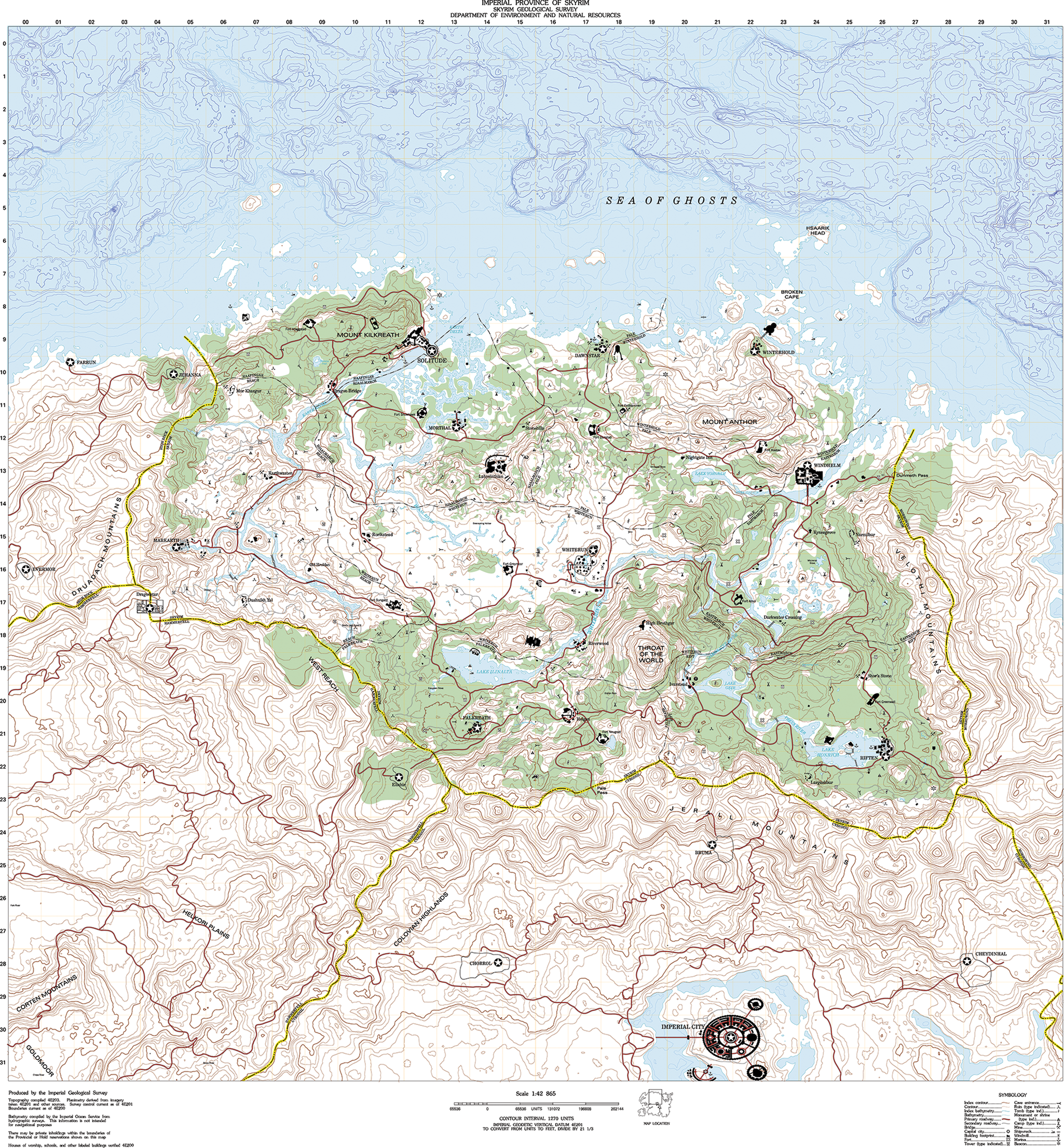
FIGURE 1. Timothy Cook's topographic map of Skyrim derived from The Elder Scrolls V: Skyrim. Image CC0. Source: https://www.nexusmods.com/skyrim/mods/36159.
The present study has attempted to answer the first question within the space of a few thousand words, and it sets the stage for future studies. Developing a robust methodology to map digital environments successfully is a crucial step for every other research question and analysis.
ETHICS
Because digital spaces either are or were settled and modified by people, we needed to exercise care in the way we approached such places, maintaining a “do no harm” and “leave no trace” policy, being careful that our interactions maintain the anonymity of human players while also not interfering with other players’ agency and interactions through our own. This followed the precedent set by the No Man's Sky Archaeological Survey's Code of Ethics (Flick et al. Reference Flick, Reinhard and Meghan Dennis2017), reinforced by Dennis's (Reference Dennis2019) PhD dissertation on archaeological ethics in digital spaces, and then with the code of ethics used by Smith Nicholls and Cook (Reference Smith Nicholls and Cook2022) in their archaeological survey of Elden Ring, conducted at the same time as the present study. No human players were encountered when conducting this mapping project in No Man's Sky. We used Fortnite's replay mechanic to conduct our photogrammetry after a round of play concluded for all 100 players in a given round.
By their nature, digital spaces are affected as soon as a human agent enters them. Care must be taken to acknowledge and observe those effects on human and nonhuman agents prior to moving ahead with any fieldwork or experimentation (Graham Reference Graham, Mol, Ariese-Vandemeulebroucke, Boom and Politopoulos2017, Reference Graham2020; Romanowska et al. Reference Romanowska, Wren and Crabtree2021). Some digital environments can be fragile, and interactions within them can be destructive unintentionally. In some digital games, archaeologists can reload previous game saves in order to test hypotheses and record data, which is something not possible on nondigital sites. Other digital spaces, however, spawn only once in their current configuration, which requires additional mindfulness by researchers lest they disturb or damage sensitive areas inadvertently.
Maps (archaeological and otherwise) carry a history of colonialism with them; it is easy to fall into old habits without considering complementary perspectives such as Indigenous, feminist, and queer (Gillings et al. Reference Gillings, Hacıgüzeller and Lock2020:1–17). Although we have created a system with which to visually capture and model digital topography for GIS mapping, we realize that the resulting models and maps do not relate complete sets of data but rather provide one way (of many) for the archaeologist to interpret a digital landscape.
This kind of research includes both users and creators (i.e., tenants and landlords) of digital landscapes. Video games and virtual worlds exist as the intellectual property (IP) of their creators, some of whom have spent millions of dollars in development costs, which are recovered through commercial sales. Because of its scholarly nature, archaeological investigation and ultimate publication (such as this article) of text, images, and video captured within interactive digital built environments typically fall under the aegis of fair use/dealing. Archaeologists must read carefully, however, each game/world's Terms of Use/Service to confirm legal reproductions taken from in-game/world proprietary media. In 2022, many game companies include language to the effect that game streamers, bloggers, and others can share freely live and recorded playthroughs. In instances where no such language is used, or if the archaeologists are researching independent (indie) or other, smaller games, written permission should be sought from the rightsholder(s).
METHODOLOGY
Mapping and modeling video-game environments is not new. The Noclip website (https://noclip.website/, source code at https://github.com/magcius/noclip.website), for example, bills itself as an open-source repository of classic video-game levels for several platforms (e.g., GameCube, Wii, and Nintendo GS). Visitors can open 3D terrain models in a web browser to explore without the frenetic action and audio common to games in the Mario universe, for example. Instead of models, the Game-Maps website (https://game-maps.com/) contains level maps of popular games marked with geographic and topological features and points of interest. However, neither of these online tools produces something that can be exported as 3D and ingested into GIS software to create accurate terrain elevations. Also, neither website includes maps and models of procedurally generated digital landscapes. Consequently, we needed another way of working and examples with which to test what we had chosen.
To reflect established trends in game design and popularity, we needed to choose two types of digital games to map: (1) a game with a “static” landscape designed by a developer (something that is always the same when a player logs in) and (2) a game with a “procedurally generated” landscape (i.e., a never-before-seen space that is generated by an algorithm). The games also needed to be multiplayer in order to capture evidence of community (or isolation from a wider community). In addition, the games needed to provide human players with raw materials and opportunities to build things (e.g., houses, towers, fortifications, etc.) as part of their design. Players can then modify these digital landscapes with structures and artifacts that endure as long as the game/world permits, as explained below.
We ultimately settled on two well-established, internationally known games that provide examples of two kinds of digital landscapes: rapid and persistent. Fortnite (Epic Games, 2017) is a widely popular, free-to-play battle royal–style game that hosts groups of 100 players on a static island.Footnote 2 Constructions built by players on the island (Figure 2) last only for the duration of the battle—typically 20 minutes, or until a player destroys another's fortifications (“rapid landscape”). No Man's Sky (Hello Games, 2016) continues to be one of gaming's most popular open world/space exploration games, and it concurrently hosts thousands of players gradually settling/colonizing a procedurally generated universe.Footnote 3 Human construction of habitats, farms, and even cities (Figure 3) can persist for months or even years and are available for other players to visit and use (“persistent landscape”). The use of the term “landscape” within the context of interactive digital built environments can be understood as the underlying surface supporting its own digital version of the technosphere. It can be of either static or procedural design existing within a rapid or persistent time frame.
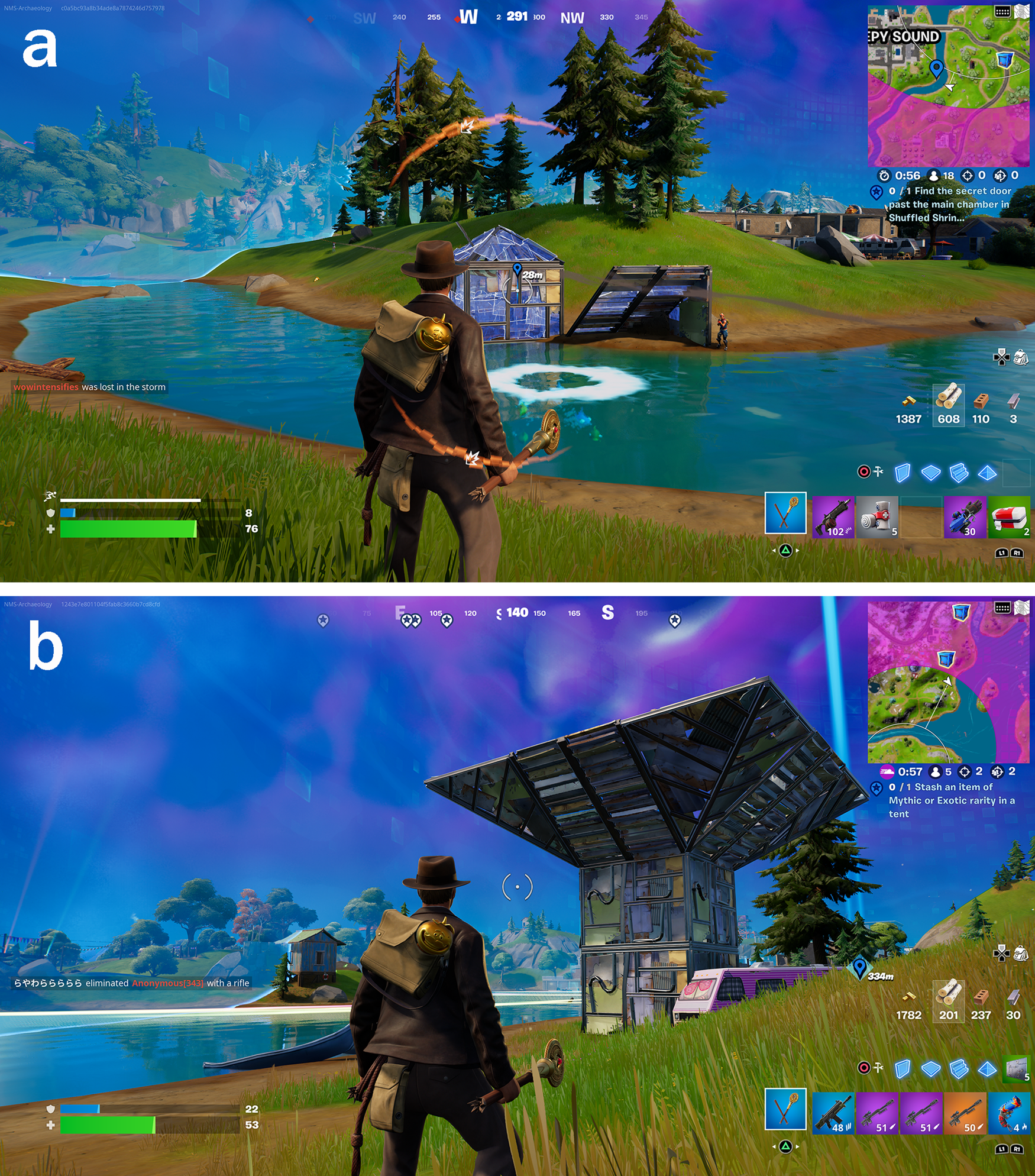
FIGURE 2. Examples of player-modified landscapes in Fortnite: (a) player-built fortification in Fortnite. Note the purpose-built “salt box” construction of the fortification (left) and the impromptu “lean-to” construction (right), with opposing player on the far right for scale; (b) player-activated, readymade “InstaFort,” which self-constructs when a player tosses its “seed” into the landscape. By chance, Chapter 3, Season 3 of Fortnite features a playable Indiana Jones avatar, pictured in the foreground. (Images courtesy of the authors.)
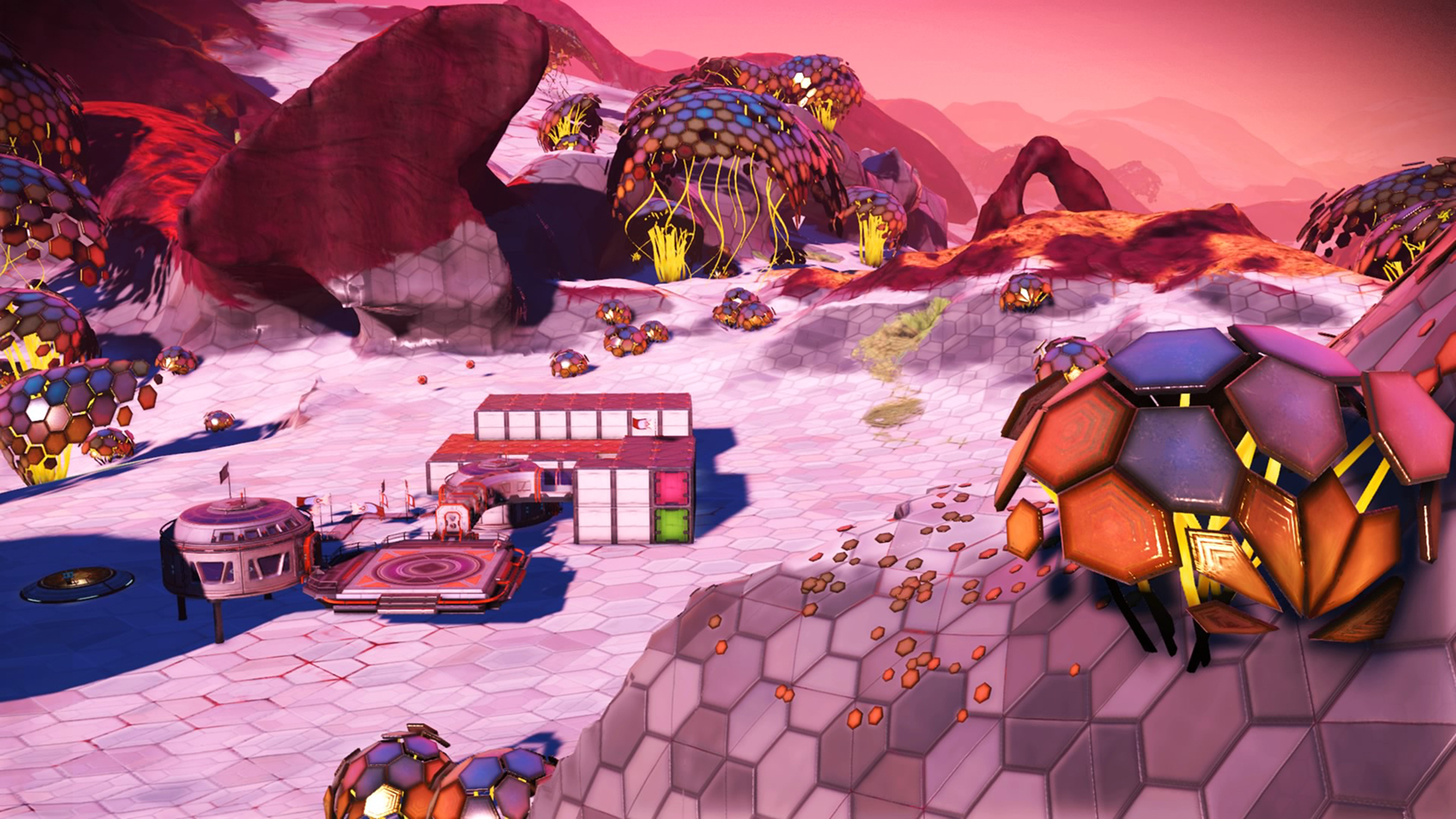
FIGURE 3. Player-built base in No Man's Sky. (Image courtesy of the authors.)
Many contemporary video games and virtual worlds do contain various levels of procedurally generated content (PCG). One of the more common PCG tools used by developers of games and CGI animation is Perlin noise, a coded algorithm that creates varying instances of textures/animations to provide subtle variety that negates the need to hand code, for example, every leaf on every tree in a video game forest. Even if a game's landscape can be understood as “static,” it likely contains PCG elements, but not to the degree of fully PCG games such as No Man's Sky or Valheim.
We acknowledge our bias in selecting the two games for this project, which we chose because of our familiarity with their operation and current settlement patterns, keeping these as “controls” to the “variable” of attempting to map these spaces for the first time. The next logical step is for another researcher to attempt to apply our methodology to a different interactive digital built environment in order to ground truth our work independently, which we hope one or more of the readers here will pursue.
We chose Fortnite because of its near-universal recognition, ease of access, potential for rapid collection of Big Data, and map, which remains constant over the course of a months-long “season.” To us, it is the best example of a rapidly changing digital landscape manipulated by human player-agents that allows for more data to be collected more quickly. The authors could easily have done something with a competing game, PUBG, but chose Fortnite because of our greater familiarity with its mechanics.
We chose No Man's Sky because it remains a best-in-class example of a procedurally generated digital environment with a years-long history of human occupation. Had either author been conversational in Eve Online, a similar game, we might have chosen that instead.
Another reason for selecting a largely PCG game (No Man's Sky) and a mostly static game (Fortnite) for this study was to demonstrate that the same tools and methods can be used successfully in both environments. Evidence of human use and occupation exists in both kinds of landscapes—PCG and static. Research questions that our methodology can help answer are (1) how humans choose to settle in a known, static space when compared to settling in an unknown procedurally generated one and (2) how people choose to occupy an area of persistent conflict voluntarily (e.g., Fortnite) as opposed to how people settle a new landscape that may or may not be hostile (e.g., No Man's Sky).
The final goal of selecting two unrelated games (rapid vs. persistent) that represent two distinct types of landscapes (static vs. procedural) was to demonstrate that the same tools and methods could be used across various examples of digital interactive visual media. Conducting photogrammetry in both games followed the same steps and used the same methods: (1) drone-based aerial photography, (2) rendering of DEMs, and (3) creating contour maps in GIS software.
Drone-Based Aerial Photography
Camera-equipped drones capture video and still images of physical and digital landscapes for the archaeologist. The methodology is largely the same regardless of the environment being photographed. Modern “open world” games and virtual worlds are designed to behave like physical environments scaled for human players, and they feature diverse topography and even biomes and climate zones for players to traverse. Many of these digital environments also provide a “photo mode” for in-game photography, which enables players to choose filters, focal lengths, and even the time of day at which to grab a shot. Photo modes often allow for photography at elevation so that players can use the in-game camera like a drone, passing it across a landscape to photograph whatever lies below.
The drone “mechanic,”Footnote 4 when used alongside screen-capture software native to a player's computer or console, can produce high-resolution imagery suitable for use in 3D rendering and GIS software. Note, however, that there is no universal photo mode or drone capability shared between games. Unlike in the physical world, where one can use the same drone and camera hardware at multiple sites, digital landscapes require the archaeologist to identify and test available functionality for aerial imagery on a site-by-site basis.
For example, in this case study, No Man's Sky's photo mode utilizes a photographic sphere with a diameter of approximately 100 m that places the player at its center. This equates to a maximum elevation of 50 m above the ground. Instead of flying a drone to capture aerial shots, No Man's Sky takes an older “balloon” approach, requiring the player to walk 50 m, activate the photo mode, snap pictures at the apex (Figure 4a), and then repeat the process over the area of investigation (Myers et al. Reference Myers, Myers and Cadogan1992). In Fortnite, however, photogrammetry was made quite a bit simpler by using the game's Replay function to allow the archaeologist to freeze the landscape at a moment in time, activate the “Free Drone” feature, and conduct an overflight at any desired altitude, pausing at will to take photos (Figure 4b).

FIGURE 4. Examples of still images captured by airborne digital drones: (a) drone-captured image above a player-built base (circled in yellow) in No Man's Sky, part of the image set used to create a digital elevation model (DEM); (b) drone-captured image above a town featuring temporary player-built fortifications (circled in yellow) in Fortnite, part of the image set used to create a DEM. (Images courtesy of the authors.)
In both instances, the “flight” pattern followed a meander. For this study, all imagery was captured on a PlayStation 5 (PS5) by using its native screen-capture tool. Images were captured at a maximum size and resolution of 3840 × 2160 pixels at 72 ppi, which is about half the desired size expected of quality drone imagery in the physical world. The PS5 also captured video at the same size and resolution as the still images, recording at 30 frames per second (FPS). After testing, we decided to use the PS5's imaging capabilities because they could operate outside of a game's Photo Mode mechanic, which in many games restricts things such as the distance between the camera and the subject. It might be possible in future experimentation to improve the size and resolution of these photos with “upscaling” software such as ON1 to improve the quality of the final model.
For both examples, the authors found that splitting overflight video into dozens (or hundreds) of still frames in Adobe Photoshop yielded low-quality imagery for use in creating 3D terrain models (DEMs). Much better results were achieved by taking still photographs, making sure that each subsequent photograph overlapped the prior shot's geographic area by a minimum of 50%, with 66% overlap being ideal for creating high-definition, accurate terrain models. The authors found that the more time and care was spent on photography, the better the end result. Typical photo sets used for testing ranged from 100 to 150 images for the best coverage, with more than 300 being excessive and less than 50 being insufficient.
Note that photogrammetry served either one or two purposes within these games, which likely reflect its application within myriad other interactive digital built environments. For a game such as Fortnite, where the topography remains constant for actual months even though individual instances last only moments, the single purpose of the photogrammetry conducted here was to capture human, temporary constructions within the landscape. Although the authors' main goal of using photogrammetry in digital spaces is to document evidence of human activity, it was also used to acquire images for landscape reconstruction. Landscape reconstruction is particularly crucial in games that feature procedurally generated landscapes, such as No Man's Sky, because they are unique, never before seen, and might not ever be again encountered in the wild.
Rendering 3D Terrain Models
Prior to experimenting with terrain maps, the authors were confronted with two major issues unique to digital terrain. First, scale is often implied—but not explicit—in many open world games and virtual worlds. Because these environments are designed with human occupants in mind, however, one can infer scale in most cases, applying it to the digital terrain model prior to exporting it for use in GIS software. This was true of Fortnite (Figures 5a and 5b). Things were somewhat easier in No Man's Sky (Figures 5c and 5d), which employed a metric unit of measure (m) for meters, thereby affixing precision to scale measurements when applied to exported drone imagery.
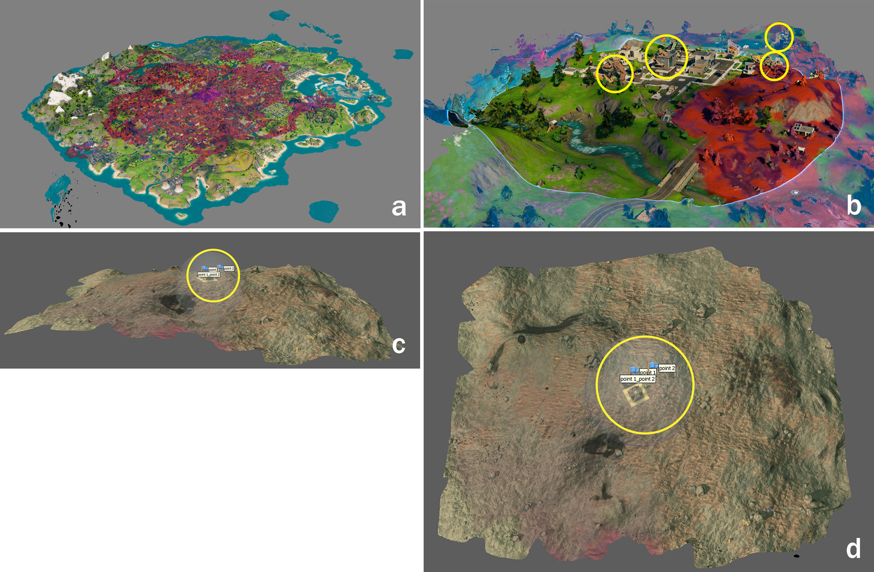
FIGURE 5. Examples of rendered terrain maps assembled in Agisoft Metashape Pro from digital drone imagery: (a) rendered terrain map of Battle Royale Island in Fortnite; (b) detail of rendered terrain map in Fortnite showing player fortifications (circled in yellow); (c) view from the side of a rendered terrain map of a site (circled in yellow) in No Man's Sky in Metashape Pro; (d) top view of a rendered terrain map of a site (circled in yellow) in No Man's Sky in Metashape Pro. (Images courtesy of the authors.)
The second problem with digital landscapes is arguably the more important of the two, especially when faced with the need to add contour lines to mapped terrain: elevation of digital space is an illusion. Digital interactive environments are often classed as “2.5D”—something between two and three dimensions—acknowledging the digital 3D simulacrum created through coding for two-dimensional representation on screens. Thanks to drone mechanics present in many modern games/worlds, and to more photorealistic art design containing topography-created shadows/shading, terrain-modeling software is able to interpret the imagery properly. This is also due in large part to the actual parallax shift present between sequenced drone images. This problem suggests an actual limit to our method of photography—namely, that it can be applied only to digital environments where depth is hard-coded into them. For human-occupied “flat” maps, it will be easier and perhaps more logical to screenshot these and then hand plot areas of human modification after importing them into GIS software.
Processing digital environment imagery works in the same way as with drone photography of physical landscapes. For this case study, the authors chose cross-platform software they were familiar with from past and current “normal” archaeology: Agisoft's Metashape Professional (see Supplemental Text 1). As with any rendering software, the nature of the complexity of creating pointclouds consumes an enormous amount of computing resources no matter from where the images were sourced.Footnote 5 To test, Sara Zaia used her Windows gaming computer, which has high-level specs: ASUS ROG GL 502 V Processor, Intel(R) Core(TM) i7-7700HQ CPU @ 2.81 GHz, installed RAM 16 GB expandable to 32 GB, Invidia GEFORCE GTX (1GB dedicated) 64-bit operating system, x64-based processor. Andrew Reinhard used his 2015 MacBook Pro, which ran the absolute minimum specs: factory standard 2.7GHz Intel Core i5, 8GB RAM. Although the resulting DEMs were identical (i.e., the same features were present in both high- and low-resolution files), Reinhard had to render the pointcloud overnight, a process that took Zaia less than an hour. To the authors’ pleasant surprise, the visual output looked similar to more traditional archaeological photogrammetry resolved from photos.
Creating Contour Maps in GIS Software
The final part in the sequence of converting a digital landscape into something usable in GIS is to import the DEM from the terrain-modeling software into GIS software for additional conversion and manipulation. For the purposes of this case study, the authors used both ArcGIS Pro and the open-source QGIS in an attempt to add contour lines to the DEM rendering of the landscapes from both Fortnite (Figures 6a and 6b) and No Man's Sky (Figure 6c; see Supplemental Text 2). Fortunately, the procedure was the same for both games and followed the same steps one uses for adding contour lines to DEMs of physical landscapes. The authors imported the GIS TIFF from Metashape Pro as a raster layer in a new project, added color, and then extrapolated contour lines ranging from 0.5 to 10 m, depending on the landscape (the 500 ha Battle Royale Island from Fortnite using the greater distance when compared to the 4 ha detail from the same island). Additional GIS layers can then be added to record everything from human constructions and natural resources to geographical features and more.
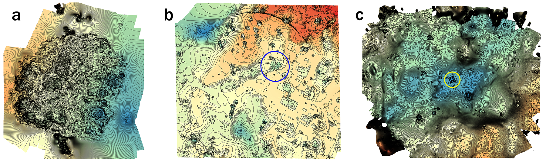
FIGURE 6. Examples of contour maps of digital landscapes rendered in QGIS: (a) contour map of Fortnite's Battle Royale Island created in QGIS; (b) detail of a contour map created in QGIS of a Fortnite town with player fortification (circled in blue); (c) contour map created in QGIS of a player base (circled in yellow) in No Man's Sky. (Images courtesy of the authors.)
DISCUSSION
It should come as little surprise that the current pace of technological invention and innovation far outstrips all previous eras, a fact that serves as both an opportunity and a warning (Aycock Reference Aycock2021). Archaeologists of more traditional media will occasionally contend with elements that put their objects of investigation at risk: environmental (e.g., fire, mudslides, animals, etc.) and/or human (looting, overvisitation, construction, etc.). However, most sites and archaeologically important landscapes change at a more natural pace, information locked within a matrix until recovered and reactivated by the archaeologist. When compared to their digital counterparts, the pace of creation, use, modification, and abandonment can seem positively languid. Prior to excavation/study, there is time to prepare and then mobilize. With the exception of salvage, this material has waited sometimes thousands of years—so what is another few months? The digital archaeologist has no such luxury.
One purpose in developing methodologies for recording digital artifacts, sites, and landscapes is to prepare current and future archaeologists on how and what to assess under the constant avalanche of human data derived from the continuous use of hardware and software by billions of people. Archaeologists are now beginning to encounter Big Data at this superhuman scale—data that constantly flow and change and are difficult to capture, preserve, and future-proof (Huggett Reference Huggett2020). Capturing individual instances of data, however, can be done, and it must be done at the source either at the time of creation or shortly thereafter lest they be lost, overwritten, or otherwise destroyed or forgotten. To document massive amounts of data, sampling seems to be a reasonable way forward. We can study the nature of a raging river by sampling it—buckets of evidence collected over time. So it is with the data stream.
HIVEs offer a way to conduct this sampling in a manner consistent with traditional archaeological training and interpretation of evidence of the human presence in the physical world. When a player builds something in a digital space, the chances are good that natural habits will persist in the synthetic landscape, albeit confined to what is permitted by the rules of the game. Although relatively new to archaeology, research into human behavior in digital environments reflective of human behavior in the physical world frequently appears in the published research of other disciplines: anthropology (Billieux et al. Reference Billieux, Van der Linden, Achab, Khazaal, Paraskevopoulos, Zullino and Thorens2013; Boellstorff Reference Boellstorff2008), behavioral science (Braun et al. Reference Braun, Stopfer, Müeller, Beutel and Egloff2016; Cochrane et al. Reference Cochrane, Prot, Blanco, Shawn Green, Gentile, Potenza, Faust and Faust2020; Shim and Srivastava Reference Shim and Srivastava2010; Subhashree et al. Reference Subhashree, Bhanu, Lavanya, Bhuvaneshwari and Aarthi2019), neuroscience (Lamb et al. Reference Lamb, Annetta, Hoston, Shapiro and Matthews2017), psychology (Halbrook et al. Reference Halbrook, O'Donnell and Msetfi2019; Norman et al. Reference Norman, Clark and Walker2005; von der Heiden Reference von der Heiden, Braun, Müller and Egloff2019), and sociology (Seay et al. Reference Seay, Jerome, Lee and Kraut2004; Williams et al. Reference Williams, Ducheneaut, Xiong and Yee2006). Archaeologists can borrow from this field-adjacent research while also contributing to it. If other disciplines have found merit in studying human–digital behaviors in these spaces, archaeology can (and has) as well.
Through familiarity with a site, the archaeologist can begin to see patterns from the samples taken through screenshots and video capture. It is possible to sift through all of that data created by all of those users to focus on one structure built by one player at a single point in time and compare that later to others in the cumulative sample set where n could be 100, or 1,000, or more. The single, temporary site combines with others like it to answer questions about human behavior in synthetic spaces based on the material culture people make for themselves, curated by the rules of creation set within the borders of the site of Fortnite, No Man's Sky, or any other digital landscape.
What is by its very nature trivial (a player putting up a defensive wall in a few seconds of panic online), when combined with tens of thousands of similar constructions by similar players in similar situations over the course of an hour, creates something of substance. This is not in the digital spaces per se. Rather, it is something that bleeds through the porous membrane shared between the digital and physical worlds. The fact that digital built environments are often useful, frequently fun, and sometimes addictive means that their repeated microtransactions continue to compound enough to create entire emergent economies, affect jobs, and consume enough electricity to support the electronic devices used to both host and access these spaces internationally. In order to begin drawing conclusions about human creation, use, modification, and abandonment of their own constructions in digital space, one must understand that things occurring at a “quantum” (tiny, extremely fast, and nearly impossible to observe) level emerge as something exhibiting Newtonian behavior with very real inertia. Great things come from small beginnings, and those beginnings can be captured and mapped through photogrammetry.
The methods described above can also benefit those earthbound archaeologists engaged with agent-based modeling who wish to test theories of migration, route finding, resource gathering, and other important research questions in a procedurally generated sandbox. This can now be done through GIS maps derived from drone-based photogrammetry of new landscapes in games such as No Man's Sky. One can first test rules of human movement through a physical landscape via satellite maps, and can then run similar tests in procedurally generated synthetic landscapes to see if the rules hold up.
Another opportunity for deploying the methods described above lies in Earth's orbit. For the archaeologists currently studying the International Space Station, only relative, descriptive locations of items aboard the ISS were recorded (Salmond et al. Reference Salmond, Walsh and Gorman2020). Nonearthbound objects are excluded from sets of GIS maps and GPS coordinates. In effect, orbital inhabited environments such as the ISS are new, self-contained landscapes not unlike the games described above. We have provided a possible method to create DEMs and GIS maps of these orbiting spaces, which can assist researchers in communicating loci of objects with precision within orbiting interiors.
CONCLUSIONS
This article has attempted to demonstrate the theory and method of engaging drone-based photogrammetry of digital landscapes within interactive digital built environments occupied by human agents as evidenced by their constructions. The purpose of this exercise was to show that such work could be done without diverting too far away from established best practices conducted in traditional, physical spaces. Digital landscape archaeology (i.e., “postlandscape”) is an emerging field, its creation obviated by the fact that billions of people spend multiple hours per day engaged with digital devices and the software run on them (Dautovic Reference Dautovic2022; Yanev Reference Yanev2022).
Note that the work presented here focuses on the evidence of human occupation of “base games”—that is, game code that has not itself been modified by the user community. Online modding communities such as NexusMods (nexusmods.com) and Planet Minecraft (planetminecraft.com) not only give players the opportunity to craft objects and spaces within gaming environments but also enable people to play with the physics and game mechanics as well. In the future, mods might very well include those created by archaeologists to assist in conducting archaeological investigations within games and virtual worlds. We have described what can be done at the bare minimum with photogrammetry and mapping of base games, providing a foundation for future work in more complex human-occupied digital environments where the player-created mods are themselves artifacts and evidence of material culture.
Humans often create spaces for themselves digitally—ones that leave either little or no trace on the physical environment other than a measurable contribution to collective electrical consumption. Although this behavior is observable in the physical world, the digital archaeologist must cohabit synthetic environments at times side-by-side with their subjects of study in order to record activity and data contributing to an understanding of human presence manifested in the activity of digital creation.
Understanding the context remains an essential part of any archaeological investigation, and research within human-occupied digital landscapes is no exception. Although the methods presented in this article can certainly be used in “black box” scenarios, better data can be retrieved by first conducting preliminary reading on player-community sites (i.e., game-related wikis and subreddits) regarding why and how people build things for themselves in video games and virtual worlds, how long this evidence persists, and what happens upon abandonment and/or destruction. For example, Fortnite players discuss survival-construction tactics such as “turtling,” which can then be video/screen captured on the battlefield by researchers (https://www.reddit.com/r/FortniteCompetitive/comments/b0xru0/why_turtling_is_such_a_big_issue_in_fortnite/). The resulting terrain model can then be used to check the proximity of this fortification to those of other players at the same point in time within the game's round, as well as where it was positioned in the landscape. In No Man's Sky, player communities discuss the locations of valuable natural resources that either can be mined or cultivated as cash crops (https://www.reddit.com/r/NoMansSkyTheGame/comments/97hn0f/no_mans_sky_farming_bases_money_makers/). Archaeologists can then visit these player-created refineries and farms to consider elements of design and placement of these structures within a resource-rich landscape. Following that in-game analysis, one can extrapolate human behaviors in digital spaces that might also differ (or be similar to) nondigital landscapes. Does digital behavior bleed into nondigital environments and vice versa?
Photogrammetry enables the archaeologist to preserve digital space in a single moment in an accelerated digital timeline, using that baseline to measure and record additional examples.Footnote 6 Taken collectively, these individual examples can make up a large dataset that, when examined with techniques developed for archaeological GIS, can shed light on more general human behavior within synthetic environments.
Returning to the natural, nondigital world, these game-based investigations can help explain digitally driven human impact on the natural world and physical landscapes, which will only increase as more and more people emigrate to digital platforms—something especially prevalent during the COVID-19 pandemic (Skwarczek Reference Skwarczek2021), but a trend in digital migration that is well known to researchers (e.g., Castronova Reference Castronova2007): not just games but any social software, especially massive online communities such as Meta, which contain a visual “virtual” component accessed through virtual or augmented reality hardware/viewers. In order to answer research questions about these spaces and the various ways in which they transform landscapes and the people occupying them, data must be collected and shared at a very fine grain. The tools and methods presented here are but one small step in preparing for a present and future archaeology of human spaces that are extremely fragile and prone to disappearing without warning.
Acknowledgments
The authors wish to thank the anonymous peer reviewers for their comments.
Funding Statement
This research did not receive any specific grant from funding agencies in the public, commercial, or not-for-profit sectors.
Data Availability Statement
The original drone-taken photo sets, stitched images, DEMs, and terrain maps are currently located on a shared Google drive. All data are available upon request by emailing the corresponding author, Andrew Reinhard, at ar6507@nyu.edu.
Credits
Taxonomy: Reinhard, A.: conceptualization, methodology, formal analysis, investigation, resources, writing of original draft, writing the revisions and editing, visualization, supervision, and project administration. Zaia, S. E.: Conceptualization, methodology, data processing, validation, investigation, writing of original draft, and writing revisions and editing.
Supplemental Material
For supplemental material accompanying this article, visit https://doi.org/10.1017/aap.2022.30.Footnote 7
1. Supplemental Text 1. How to Create a Dense Pointcloud, Mesh, and Digital Elevation Model (DEM) in Agisoft Metashape Professional v1.7.5.
2. Supplemental Text 2. How to Create Contour Lines for the Terrain Model in QGIS v3.4x.
Competing Interests
The authors declare none.


 Open access