


INTRODUCTION
The Caves of Pertosa preserve within them an archaeological site of extraordinary scientific interest (Carucci Reference Carucci1907; Larocca Reference Larocca2010). It was shaped over several thousand years as the result of multiple human activities and it has returned abundant evidence of material culture connected to the various human groups that, from prehistory to medieval times, frequented the cavity (Larocca Reference Larocca2017). Certainly, the particular fortune of the site is the reflection of excellent and advantageous conditions for human settlement such as the large dimensions of the initial underground environment, the good light conditions deriving from the large entrance, the natural availability of fresh water directly on site, the favorable position along the course of the Tanagro River, which is part of an important natural communication route through the Southern Apennine mountain range. All these characteristics made the cavity a privileged resting place for the different human groups who frequented the area (Larocca, Reference Larocca2017).
The advantages of a stable occupation within the so-called “antegrotta” (the first, initial part of the caves) emerged clearly during the protohistoric era, when almost all the underground space available in the first 100 meters of the cavity, along the banks of the underground stream, was equipped with a wooden structure similar to a stilt house (Patroni Reference Patroni1899; Carucci Reference Carucci1907; Breglia and Fiorentino Reference Breglia and Fiorentino2017). It was probably used to solve a problem with which humans had to deal recurrently: the swamping of the banks on the sides of the watercourse and, in particular moments, perhaps even their temporary submersion. The pile dwelling, artificially raising the passable floor in the initial part of the cavity, made available and fully usable, an area that would otherwise be subject to changing conditions associated with the variability of the water flow of the stream.
For this phase, the importance of the site lies in three main reasons: (i) the very peculiar settlement choice represented by the construction of a pile-dwelling inside an active karst cave; (ii) despite its modest size and the absence of fortifications, the site is well inserted in a wide network of contacts (Acquafredda Reference Acquafredda, Larocca and Pallara2017; Breglia Reference Breglia2020), even on a large scale, and has yielded a considerable amount of valuable metal goods, weapons, ornaments, exotic artifacts and various indicators of wealth (Rellini Reference Rellini1916; Bettelli Reference Bettelli2002; Albore Livadie et al. Reference Albore Livadie, Bietti Sestieri and Marzocchella2004; Lo Schiavo Reference Lo Schiavo2010; Larocca et al. Reference Larocca, Laino and Carloni2018); (iii) the dual function of the site which, alongside the evidence of a residential/domestic occupation, shows evidence of cults, probably linked to the sacred nature of the groundwater (i.e., the abandonment of weapons in the watercourse (Rellini Reference Rellini1916; Kilian Reference Kilian1963–1964; De Falco and Larocca Reference De Falco and Larocca2017) and the ritual deposition of miniature jars in the cracks of the cave walls (Patroni Reference Patroni1899; Carucci Reference Carucci1907; Fuscone Reference Fuscone2013).
The good conservation, in the bed of the watercourse, of the edges of the pile dwelling system, led the archaeologists—between 2004 and 2013—to carry out a series of studies and documentation interventions of the surviving evidences (Larocca Reference Larocca2017; Larocca and Breglia Reference Larocca and Breglia2018). Nevertheless, stratified deposits are generally not preserved in this area, except in rare specific cases where the erosion of the watercourse has not affected the sediments. This creates a situation in which the evidence on the surface (poles, pottery and other finds) constitutes a palimpsest of several occupation phases of the same places, with a consequent apparent chronological flattening. Data from previous excavations in other areas and most of the material culture in the riverbed pointed towards a chronological attribution of the wooden structures to the Bronze Age. However, in the absence of radiometric dates, it was impossible to attribute the structures to a more specific Bronze Age period or to define whether the choice to build on stilts lasted for the entire protohistoric settlement lifespan or not. On the occasion of these fieldworks, therefore, wood was sampled in order to allow following laboratory analyses.
The outcome of these investigations led to the achievement of various results: the identification of the pile dwelling extension, the general characteristics of the wooden structures, the plant species used for the construction of the artifacts and structures (Breglia Reference Breglia2020) and, above all, their chronology.
In this paper we report on the results obtained by radiocarbon dating some of these samples, allowing the assessment of the different frequentation phases of the site.
SITE DESCRIPTION
The Pertosa Caves open at 263 meters above sea level on the left bank of the Tanagro River, on the eastern slopes of the Alburni Mountains (Figure 1, A). The cavity, from a speleological point of view, constitutes a karst spring returning to the surface the waters of an underground river with variable water flow, between 350 and 600 L/s (Larocca Reference Larocca2010).

Figure 1 (a) Location of the “Grotte di Pertosa” (edited by F. Breglia). (b) view of one of the cave branches completely flooded by underground stream (photo by P. Ippolito and A. Pilia); (c) Map of the cavity (after Larocca Reference Larocca2010, Tav. I, modified).
The 3-km-long cave consists of three almost parallel branches called, from north to south, the Tourist, the Speleological and the Spring Branch. The first hosts a path open to the public that crosses highly concreted environments with a valuable aesthetic aspect; the second is a pipeline characterized by considerable accumulations of mud and collapse deposits; the third is completely invaded by the waters of the underground stream, which flows for about one third of the total development of the cave and finally re-emerges on the surface, rejoining the course of the Tanagro River (Figure 1, B–C).
The area of archaeological interest is located in the first 100 meters of the cavity (Figure 1, C), in immediate contact with the natural entrance to the underground system. Although the entire cavity has been the subject of careful exploration, the evidence of ancient human presence is concentrated exclusively in the aforementioned “antegrotta” a transition area between the surface and the underground world. It is here that the archaeological site is preserved, characterized by the remains of the ancient protohistoric pile dwellings, still visible in the silts of the submerged seabed.
Archaeological Background
The history of the research in the Pertosa Caves begins in the late nineteenth century when two scholars, Giovanni Patroni and Paolo Carucci, investigated the deposits in the initial portion of the cavity (Larocca Reference Larocca2010, Reference Larocca2017). The first started the excavations in 1898, investigating the bank of the underground stream to a depth of 90 cm and identifying 7 layers rich in archaeological materials, the last of which included an ancient well-preserved wooden structure (Patroni Reference Patroni1899) (Figure 2, A–B). Later the investigations were resumed by Carucci who deepened and extended the previous excavation (Carucci Reference Carucci1907). The latter reached a depth of about 3 m and investigated a sequence of eleven layers, the seventh of which corresponded to the already known pile dwelling, while the tenth incorporated a second—and more ancient— pile dwelling.

Figure 2 Historical photograph (a) showing the ancient well-preserved wooden structure and (b) the structures brought to light by the excavations carried out by Patroni (after Patroni Reference Patroni1899). (c) graphical reconstruction of the dwelling system (after Patroni Reference Patroni1899, modified).
The investigations by Patroni and Carucci led to the recognition of different phases of human frequentation of the cavity which, albeit with different hiatuses, covered the last six thousand years. The superficial layers, in fact, incorporated materials from the Middle Ages and Hellenistic-Roman periods while, below, lay the layers that can be classified in the protohistoric age, with some sporadic elements referable to the recent Neolithic.
The ceramic finds indicate that the period of most intense occupation of the cave was the middle Bronze Age. The protohistoric attendance however lasted until the early Iron Age (Trucco Reference Trucco1991–1992; Fuscone Reference Fuscone2013; Savino et al. Reference Savino, Fico, Pennetta and De Benedetto2017). The presence of materials dated to the ancient Bronze Age among those found by Carucci also suggests an older phase (Trucco Reference Trucco1991–1992), perhaps connected to the construction of the deeper pile dwelling structure.
The construction of a dam at the entrance to the cavity, erected for the hydroelectric exploitation of the waters, led to the complete submergence of the excavation field and the cessation of any research activity for about a century. Only between 2004 and 2013 it was possible to resume field surveys (carried, with three interventions on the ground, by a team of speleo-archaeologists of the C.R.S. “Enzo dei Medici”), carried out in an area of the antegrotta never investigated before.
Currently, the archaeological collections from the site are housed in four different Italian museums: the National Archaeological Museum in Naples, the Provincial Archaeological Museum in Salerno, the Museum of Civilizations in Rome (formerly the “Luigi Pigorini” National Prehistoric Ethnographic Museum) and the speleo-archaeological Museum “MIdA 01” in Pertosa.
The Dwelling System: Archaeobotanical Background
There is a substantial difference between the research carried out at the end of the nineteenth century and those carried out in recent times. Indeed the first one concerned the excavation of the earthy bank—a conservative environment where the sedimentation of silt-clayey deposits incorporated the archaeological evidence—while the second case research took place directly in the riverbed: an erosive environment, where for millennia the incessant action of water led to the dislocation or removal of deposits. In the riverbed different areas preserving important remains of the pile dwelling structure have been identified, with very rich accumulations of plant remains. The peculiarities of the two different contexts affected the state of conservation of the remains and, inevitably, the type of evidence found. Along the watercourse the predominant surviving elements are the vertical poles that supported the upper pile dwelling structure, the platform that can be walked on, while the nineteenth-century excavations had brought to light the entire wooden deck, i.e., both the horizontal and vertical parts.
In the so-called “upper pile dwelling” the deck was made of boards placed side by side, which formed the support base for the floors. These boards rested on horizontal beams obtained from young trunks or large branches, at the ends of which there were “Y” openings so that they could fit into the pointed apex of the vertical poles. The latter were robust and deeply embedded in the underlying sediments; each of them providing support for two beams in such a way as to form a square mesh system. The entire structure was covered with a layer of oak bark laying at the base of a beaten made of clay mixed with plant elements such as broom, reeds, and ferns (Patroni Reference Patroni1899) (Figure 2, C). This pattern was not observed in the entire area: in some areas, in fact, different techniques and characteristics have been recognized that suggest the existence of several construction phases.
Recent research, on the other hand, has shed light on the spatiality of the evidence, attesting that wooden structures were built on the entire antegrotta, in an area of about 600 m2 (Breglia and Fiorentino Reference Breglia and Fiorentino2017; Breglia Reference Breglia2020). The survey of the area also made it possible to discriminate at least two distinct groupings of poles, one closer to the entrance, the other more internal (Figure 3, A).
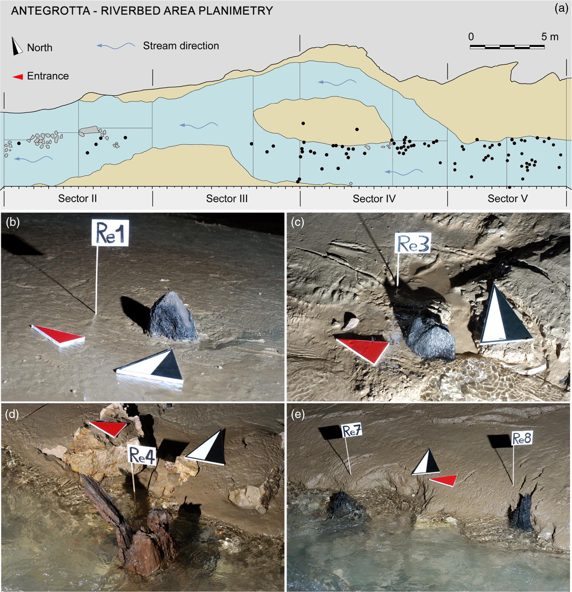
Figure 3 (a) plan of the riverbed with the position of the raised vertical poles, indicated by black dots (elaboration by F. Larocca and F. Breglia). (b–e) some apexes of the vertical poles submitted to radiocarbon dating emerging from the silty deposit of the stream (photo by F. Larocca).
Forty-six piles (sampled directly in the riverbed, Figure 3, B–E) and 22 horizontal structural elements, coming almost exclusively from the excavation of Patroni and relevant to the upper pile dwelling, were analyzed from an archaeobotanical point of view by microscopic observation of the wood anatomy (Breglia and Fiorentino Reference Breglia and Fiorentino2017; Breglia Reference Breglia2020). As far as the wood raw materials used for the construction of the structures are concerned, archaeobotanical investigations unequivocally identified a selection of deciduous oaks (Quercus type robur) and semi-deciduous oaks (Quercus type cerris). These two groups of taxa were recognized overall in 91.2% of cases: in particular 70.6% is represented by deciduous oaks (34 posts and 14 horizontal elements) and 20.6% by semi-deciduous oaks (9 poles and 5 horizontal elements). The remaining elements represent a small part of the total: the evergreen oaks (Quercus suber group) 4.4% (2 poles and 1 horizontal element), the yew (Taxus baccata) 1.5% (only one pole) while it was not possible to determine two horizontal components (2.9%).
Oak species (Quercus spp.) produces an excellent wood, resistant, elastic, and heavy (Giachi et al. Reference Giachi, Lazzeri, Macchioni, Mariotti Lippi and Paci2003). It has good durability even in immersion conditions, thanks to the high tannins content (Gale and Cluter Reference Gale and Cutler2000). The main mechanical characteristics are compressive strength, tensile strength and durability even in alternating wet/dry situations. In addition to the mechanical properties, oak wood is easy to work (Nardi Berti Reference Nardi Berti2006), especially by splitting, following the direction of the large parenchymatic rays (Giordano Reference Giordano1981). This technique is well attested in the analysed sample, recognized both on the horizontal structural elements and on some vertical poles.
Considering the temperate climatic zone and the piedmont altitudinal belt, it is plausible that a large coverage of mixed temperate forest was present near the site. This type of forest is dominated, in the tree layer, by oaks which are among the most common trees in the temperate belt. On the basis of the microclimatic characteristics of exposure and soil drainage, populations of deciduous, semi-deciduous or evergreen oaks may prevail locally, which in any case must have been widely available, then as now (Breglia and Fiorentino Reference Breglia and Fiorentino2017).
MATERIALS AND METHODS
Some of the samples selected for archaeobotanical analyses were submitted to radiocarbon dating (Table 1). Six poles were sampled, five of which from Sectors IV–V and one from Sector II. Two horizontal structural elements preserved at the National Archaeological Museum in Naples were also selected for dating. It is to be underlined that “old wood effect” cannot be ruled out in this case, considering the wood species (oak). Although this could potentially badly impact the achieved accuracy of the chronological reconstruction, short living species were not available as alternative samples (Kim et al. Reference Kim, Wright and Hwang2019). In any case to try to mitigate the impact of this effect, the outer rings were always selected for the analyses.
Table 1 Summary of the analyzed samples and obtained conventional radiocarbon ages.

In addition, four other samples from sector VI were selected, where a well-preserved layer rich in plant remains was identified, which revealed evident traces of cereal processing and consumption of fruit and wild plants; some caryopsis of Triticum dicoccum and a grape seed (Vitis vinifera) were taken from it and submitted to radiocarbon dating. Finally, a large trunk of wood was collected a short distance away, in a secondary position and half-buried by modern sediments, interpreted as a waste of ancient carpentry work. All the samples were dated by AMS (Accelerator Mass Spectrometry) at the Centre of Applied Physics, Dating and Diagnostics at the University of Salento (Calcagnile et al. Reference Calcagnile, Maruccio, Scrimieri, delle Side, Braione, D’Elia and Quarta2019).
Sample Processing
Selected samples showed a good preservation status and they were analyzed at CEDAD (Centre of Applied Physics, Dating and Diagnostics), Department of Mathematics and Physics “Ennio de Giorgi”, University of Salento by using the AMS beamline and based on a 3 MV Tandetron accelerator (Mod. HVEE 4130 HC) (Calcagnile et al. Reference Calcagnile, Quarta and D’Elia2005). The samples were processed according to standard procedures as detailed in D’Elia et al. (Reference D’Elia, Calcagnile, Quarta, Rizzo, Sanapo, Laudisa, Toma and Rizzo2004). In particular all the samples were observed at the optical microscope in order to highlight and mechanically remove macro-contaminants and select the portion (typically 30–50 mg) of the samples more suitable for the following chemical processing. It consisted in the AAA (acid-alkali-acid) treatment which was performed by applying alternate acid (HCl), base (NaOH) and acid (HCl) intended to remove exogenous sources of carbon. The good preservation status of the samples suggested not to follow more selective and aggressive sample processing procedures such as cellulose extraction. Indeed, authors have demonstrated that acid-base-acid (ABA) is well suitable for reliable results, while circumventing wood loss during chemical dissolution, especially for samples with ages well above the radiocarbon limit Santos and Ormsby (Reference Santos and Ormsby2013).
The purified sample material was then dried at 60°C and sealed in pre-evacuated quartz tubes (< 10–4 mbar) together with silver wool and copper oxide. The samples were then combusted at 900°C for 4 hr and then the released CO2 recovered and cryogenically purified at the sample processing lines of the laboratory (D’Elia et al. Reference D’Elia, Calcagnile, Quarta, Rizzo, Sanapo, Laudisa, Toma and Rizzo2004). The purified carbon dioxide was then converted at 600°C to solid graphite by using high purity H2 as reducing agent and Fe powder as catalyst. Reaction water was removed during the process by a water trap kept at –40°C with a cold finger. All the samples yielded ∼1 mg of graphite which is considered optimal for the following AMS measurement.
The extracted graphite was pressed in the Al target holders AMS ion source. Carbon isotopic ratios were then measured with the AMS system by comparing the beam currents (for 12C and 13C stable isotopes) and the 14C ionization events in the GIC (Gas Ionization Chamber) obtained for the samples with those obtained with IAEA C6 sucrose standards used for normalization. The measured 14C/12C isotopic ratios were, after correction for isotopic fractionation and processing and machine blank, used to calculate the conventional radiocarbon ages according to Stuiver and Polach (Reference Stuiver and Polach1977).
Conventional radiocarbon ages were then converted to calendar ones by using the OxCal Ver 4.3 package (Bronk Ramsey et al. Reference Bronk Ramsey2001) and the IntCal20 calibration curve for atmospheric data (Reimer et al. Reference Reimer, Austin, Bard, Bayliss, Blackwell and Bronk Ramsey2020).
RESULTS
The results obtained on the analyzed samples are given in Table 1 and are expressed as conventional radiocarbon ages in years BP. The results of calibration are shown in Figure 4 where dark and light grey areas represent one standard and two standard deviations calibrated time ranges. Radiocarbon data show that all the samples (except one) refer to a chronological horizon spanning from the 17th to the 11th centuries BC. This allows to ascertain the substantial homogeneity of the dating in agreement with the evidence of the material culture indicating that the phase of greatest use of the cavity was in the Middle III and in the Recent bronze ages. Indeed, the life of the site starts at least from an initial moment of the Middle Bronze Age and continues until the beginning of the early Iron Age, highlighting a rather long and articulated protohistoric frequentation of the cave spanning from the 17th to the 11th centuries BC.

Figure 4 Calibration of radiocarbon ages for the analyzed samples.
The only discordant element with this chronological framework is a pole located in Sector II, in an isolated position with respect to the others, which is dated in the late medieval/modern age and certainly represents the indication of some other structure built in the ante-cave for currently unknown reasons.
CONCLUSIONS
We have presented the results of the radiocarbon dating campaign carried out on samples selected from the wooden structures recovered in the “Pertosa” caves in Southern Italy. Radiocarbon data allowed to assess the wide chronological range of the human frequentation of the caves and of the exceptionally well preserved underground pile dwelling system. The obtained results are well in agreement with what was expected on the base of archaeological analysis except for one of the samples which gave a much younger age probably associated with Middle Ages wooden structures. Further studies are already planned to increase the number of available data, enhance the achieved resolution, and better reconstruct the different occupation phases.


