


Societies around the world have created what are often known as tell sites, i.e. cultural mounds composed of strata of architectural remnants, built up over time. Widely studied due to their rich, informative archaeological deposits, there is ongoing debate regarding how to interpret the diverse cultural choices that lead to their formation. In the past few decades, the assumption that tells form ad hoc or passively as structures are abandoned, filled with trash and levelled for new construction has come under increasing critique. Instead, archaeologists are emphasizing the active decisions and intentional processes that lead to their creation (Blanco-González & Kienlin Reference Blanco-González and Kienlin2020; Chapman Reference Chapman, Gustafsson and Karlsson1999; Chapman & Gaydarska Reference Chapman and Gaydarska2007; Dueppen Reference Dueppen2022; Duffy et al. Reference Duffy, Parditka, Giblin and Paja2019; Gyucha et al. Reference Gyucha, Parkinson and Yerkes2019; Hadad Reference Hadad2019; Haddow et al. Reference Haddow, Sadvari, Knüsel, Hadad and Osterholtz2016; Hodder Reference Hodder2018a,Reference Hodder, Souvatzi, Baysal and Baysalb; Reference Hodder2022; Hodder & Marciniak Reference Hodder and Marciniak2015; Hodder & Pels Reference Hodder, Pels and Hodder2010; Hofmann et al. Reference Hofmann, Moetz and Müller2012; Karkanas & Efstratiou Reference Karkanas and Efstratiou2009; Karul Reference Karul2021; Kloukinas Reference Kloukinas2015; Özdoğan Reference Özdoğan2018; Parkinson et al. Reference Parkinson, Gyucha and Karkanas2018; Sofaer Reference Sofaer2011; Verhoeven Reference Verhoeven2000).
As archaeologists assess life-histories of architectural units, they are finding evidence of purposeful actions such as burning (which fires earthen architecture) and quick-sealing of deposits as well as variability in the degree of deconstruction of existing or former structures prior to new construction. For example, detailed study of the histories of various structures at Çatalhöyük has yielded insights into the religious beliefs and active processes that produced the particular deposits (Hodder Reference Hodder2018a,Reference Hodderb; Reference Hodder2022; Hodder & Marciniak Reference Hodder and Marciniak2015; Hodder & Pels Reference Hodder, Pels and Hodder2010; see also Özdoğan Reference Özdoğan2018 regarding ritual burial of architecture in the Neolithic Near East). Decisions such as which elements to keep when reflooring (parietal art, room features) or whether ritual depositions need to be laid before reflooring have enabled archaeologists to identify commonalities and variance within the architecture. These in turn have been used to reconstruct a dynamic social environment where cross-cutting associations and relationships intersected with ancestral belief. In southeastern Europe, structured depositions including deliberate house burning, ritualized pits and fragmentation of material culture have been used to examine the complex relations between people, places and objects (see Chapman Reference Chapman, Gustafsson and Karlsson1999; Chapman & Gaydarska Reference Chapman and Gaydarska2007). Overall, research worldwide has made clear that there is significant variability in the cultural processes that lead to tell formation.
Tell sites are common in West Africa in a diversity of environmental contexts and cultural zones (Fig. 1) (Andah Reference Andah1978; Cissé et al. Reference Cissé, McIntosh, Dussubieux, Fenn, Gallagher and Smith2013; Clark Reference Clark2003; Coulibaly Reference Coulibaly2006; Dueppen Reference Dueppen2012a; Reference Dueppen2022; Gallagher Reference Gallagher2021; Gestrich & MacDonald Reference Gestrich and MacDonald2018; Gokee Reference Gokee2016; Haour Reference Haour2019; Holl Reference Holl2014; Huysecom et al. Reference Huysecom, Ozainne and Jeanbourquin2015; Kankpeyeng et al. Reference Kankpeyeng, Swanepoel, Insoll, Nkumbaan, Amartey and Saako2013; Koté Reference Koté2007; Lingané Reference Lingané1995; MacDonald Reference Macdonald2011; Magnavita Reference Magnavita2015; R. McIntosh et al. Reference McIntosh, McIntosh and Bocoum2016; S. McIntosh Reference McIntosh1995; Petit et al. Reference Petit, von Czerniewicz and Pelzer2011; Shinnie & Kense Reference Shinnie and Kense1989; Stahl Reference Stahl2001; Thiaw Reference Thiaw1999; Togola Reference Togola2008; York Reference York1973). Life histories of earthen architecture have been the focus of important ethnoarchaeological and archaeological work in the region (e.g. Agorsah Reference Agorsah1985; R. McIntosh Reference McIntosh1974; Reference McIntosh1977; Ogundiran et al. Reference Ogundiran, Moyib, Daraojimba and Adeara2021; Walicka Zeh Reference Walicka Zeh2000). With origins in the second millennium bce (e.g. Davies Reference Davies1973; Shinnie & Kense Reference Shinnie and Kense1989; see discussions in Dueppen Reference Dueppen2022), tell sites became increasingly common throughout the region during the first millennia bce and ce. Like elsewhere in the world, excavations of tells in West Africa have revealed critically important insights into cultural histories and social processes, including providing a basis for relative chronologies and technological sequences. Given their wide geographic distribution, tells are connected to the histories of diverse linguistic and cultural groups in the region and their creation probably reflects dynamic cultural choices, practices and concepts of space. A distinctive feature of many of the region's tells is that they are often arranged in clusters of discrete tells, in both urban and non-urban settings.

Figure 1. Map showing selected sites and regions in West Africa where large numbers of tell sites have been identified. The distribution of tell sites in the region is much broader than shown on this map, which reflects areas that have been the subject of more extensive archaeological research. (Cartography by the Infographics Lab, Department of Geography, University of Oregon.)
While to this point we have used the term ‘tell’ to facilitate integration with the global literature, the term ‘mound’ is more commonly employed in the West African literature, where it refers not only to tells but also to burial mounds and other anthropogenic mounded features. For consistency with cited works, ‘mound’ will be used in this article when referring to tell sites in the region. However, unless explicitly noted otherwise, all West African mound sites discussed are tells and were created through the accumulation of stratified architectural remains.
In this paper we examine the cultural formation processes that resulted in the systematic preservation of well-preserved architectural remnants in spatially discrete 2–4 m high mounds at the site of Kirikongo, Burkina Faso (Fig. 2). At the site, careful excavation to sterile at five mounds anchored by 34 AMS dates has resulted in a high-resolution stratigraphy (see Dueppen Reference Dueppen2012a,Reference Dueppenb; Reference Dueppen2015; Reference Dueppen2022; Dueppen & Gallagher Reference Dueppen and Gallagher2016; Reference Dueppen and Gallagher2021; Gallagher & Dueppen Reference Gallagher and Dueppen2018; Reference Gallagher, Dueppen, Eichhorn and Höhn2019). The major excavations were supplemented by a systematic programme of site mapping, shovel testing between mounds and surface collection throughout the site. Notably, three of the mounds were cut during road construction, resulting in 60–70 m long exposed cross-sections (referred to in this paper as ‘road cuts’) that provide unique insights into stratification processes, deposition of debris and transformations in use of space on each mound.

Figure 2. Map of the site of Kirikongo showing archaeological sampling.
In Dueppen's (Reference Dueppen2022) recent analysis of the Kirikongo excavation unit stratigraphies, he argues that ancestor-related ritual practices were the primary contributors to mound formation. These practices, which are clearly distinguishable from the rare instances of abandonment and structure decay, included construction and veneration of mortuary houses in dedicated burial areas; conversion of domestic architecture to ritual space, often through use for burial with associated ritual offerings; construction of mortuary houses over the former; deconstruction of activity areas marked with ritual offerings; and emplacement of ritual foundation deposits prior to new construction.
Here, we expand on this work by integrating the first detailed presentation and analysis of the three full mound profiles exposed due to road construction through Kirikongo. Data from the road cuts confirm the widespread use of these cultural processes throughout the site and provide new insights into use of space and the construction and growth of mound deposits. The combined archaeological data from Kirikongo advance an agentive model for mound-formation processes derived from strong co-residential relationships with ancestors connected to the living community through their attachments to architecture and ritual depositions. Results call for a re-assessment of the reasons for the preservation of architectural foundations and remnants in archaeological sites, adding West Africa's mounds to recent worldwide debates on the active cultural choices creating tells.
Archaeological Mounds (Tells) in Western Burkina Faso
In western Burkina Faso, mound sites are common and clearly visible throughout the landscape. While to date few areas in western Burkina Faso have received archaeological investigation, a notable exception is the Mouhoun Bend, a region shaped by the curve in the Mouhoun River as it shifts from north-flowing to south-flowing (Dueppen Reference Dueppen2012a; Reference Dueppen2022; Holl Reference Holl, Magnavita, Koté, Breunig and Idé2009; Reference Holl2014; Holl & Koté Reference Holl and Koté2000; Koté Reference Koté2007). Over the past twenty-five years, archaeological research has established that mounds are generally arranged in clusters that can cover up to 40 ha with individual mounds typically ranging from 0.25 to 1 ha in area (although some exceed 2 ha) and 2 to 4 m in height. Systematic survey of the Mouhoun Bend region from Massala north to the Mouhoun has identified dozens of these clustered mound sites, which is likely to be representative of their frequency in the broader region. The oldest dated mound sites were established in the first millennium bce, when iron-using agricultural societies first settled in the Mouhoun Bend (Holl Reference Holl2014; Holl & Koté Reference Holl and Koté2000; Koté Reference Koté2007; see also discussions in Dueppen Reference Dueppen2022). They occupied an area that from current data was heavily forested and had probably presented challenges for previous Neolithic farmers who may have preferred the better-drained metamorphic formations of central Burkina Faso prior to increasing aridity in the first millennium bce (see Dueppen Reference Dueppen2022; Dueppen & Gallagher Reference Dueppen and Gallagher2023).
The primary focus of this paper is the 100–1500 ce deposits at the large site of Kirikongo, composed of 13 mounds, three laterite quarries or mines and three metallurgical production areas distributed over a 37.5 ha area. One additional metallurgical area was located 250 m to the west. The mounds can be divided into a 20 ha circular core that included 9 mounds with interspersed plazas, a single mound located 175 m north of the core and a linear arrangement of three mounds along the eastern edge of the site that dates to the sixteenth–seventeenth century ce.
Mound (tell) formation at Kirikongo: insights from excavation
Excavation at Kirikongo used a locus system, with each element of the cultural deposits excavated separately. Locus numbers changed at maximum every 10 cm and all sediment was screened through a 2 mm mesh (Dueppen Reference Dueppen2012a; Reference Dueppen2022). A relative sequence of ceramics and of architectural techniques was outlined for Kirikongo and anchored by 34 AMS radiocarbon dates. For the period under examination here, the sequence can be divided into two architectural phases (Yellow and Red) based upon pavement techniques, and further divided into six ceramic subphases of varying length (Table 1; Fig. 3). However, as will be seen below, even greater chronological precision was possible due to the ritualized nature of deposition at the site. Material culture was primarily recovered from temporally constrained ritual deposits, such that it is often possible to outline early, middle and late periods within ceramic subphases. The high-resolution ceramic chronology facilitates Bayesian analysis of the site's AMS dates and enables the application of dates across the site.
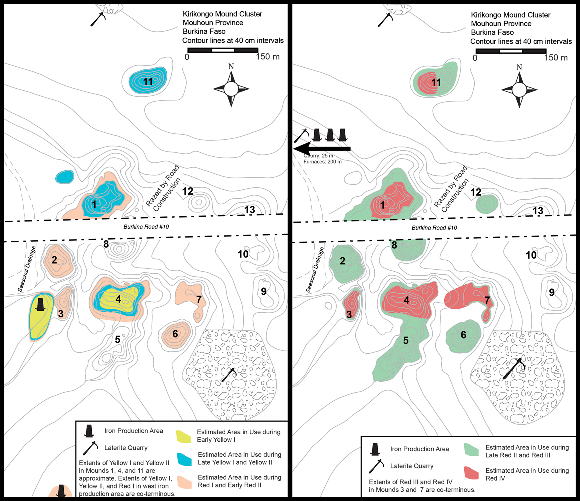
Figure 3. Spatial development of Kirikongo over time.
Table 1. Occupation phases at Kirikongo.

Architecture at Kirikongo includes structures made from coursed earth, earthen brick and, in one case, fired earthen bricks. Beginning c. 650–700 ce, the pounded yellow clay flooring used early in the sequence was largely supplanted by concrete-like pavements made of crushed laterite and clay. Most structures were round with no interior dividing walls, and short linear connecting walls helped create cellular arrangements among structures. From at least 650–700 ce, structures had flat roofs paved with the same crushed laterite pavements as floors and there is evidence from a burned ritual structure that at least in some cases activities took place on the roof or in second-storey rooms. Residential architecture was organized into walled compounds prior to the twelfth century, after which more open architectural units (room blocks) are found.
A defining feature of the Kirikongo excavation sequence is the frequent occurrence of what Dueppen (Reference Dueppen2022) has identified as ritualized depositions. These concentrated loci of material culture and the remains of funerary feasts were recovered from intentionally created small pits, concavities dug into or below architectural remains and/or in association with burials. The fauna incorporated into these ritual depositions included a common diverse set of baseline elements (primarily domestic animal sacrifices and aquatic resources) supplemented with the inclusion of particular wild animals whose ecological associations invoked alliances between houses and divinities. The material culture in these depositions was primarily single or a few well-preserved fragments from multiple ceramic vessels, a large percentage of which were from small, highly decorated pots including distinctive tripod vessels that have been well established regionally as having a ritual function (Bedaux Reference Bedaux, Swartz, Dumett and de Gruyter1980; Bedaux et al. Reference Bedaux, Constandse-Westermann, Hacquebord, Lange and Van Der Waals1978; Dueppen Reference Dueppen2015; Reference Dueppen2022; Mayor Reference Mayor2011; S. McIntosh Reference McIntosh1995). The ceramic sherds were supplemented with fragmented (or bent) locally made stone and iron objects, as well as unbroken found or non-local objects such as microlithic stone tools, a glass bead and a copper earring. Overall, the intentionality, diversity and repetition in the contents of the ritual depositions distinguished them from other deposits at Kirikongo.
A complete set of excavation unit profiles is available in Dueppen (Reference Dueppen2012a, 83–114), alongside the initial stratigraphic analysis. As stated above, Dueppen (Reference Dueppen2022) recently completed a comprehensive analysis of the stratigraphy of excavation units at Mound 1 (Unit A), Mound 4 (Unit B), Mound 3 (Unit C) and Mound 11 (Unit E); a fifth excavation unit in the eastern mound group (Unit D) post-dates this period and has not yet been fully analysed. This analysis found that excavation units could be divided into 50 depositional contexts. The unit-by-unit results are presented in full in Dueppen (Reference Dueppen2022, 115–89). This discussion focuses on the primary patterns related to mound formation identified across the units.
Architecture and stratification in Kirikongo excavations
Excavation data indicate that in most cases, mound formation at Kirikongo resulted from processes related to the construction of dedicated mortuary features marked by an architectural structure, the construction of new residential architecture and activity areas and the transitioning of residential architecture or activity areas (i.e. courtyards) to mortuary spaces. Abandonment and decay of architecture or activity areas and the catastrophic destruction of architecture both occurred but were significantly more rare.
Early in the sequence in Units A and B and for much of the sequence at Unit C, the excavated areas were used primarily for burial and memorialization of ancestors. Mortuary structures, probably houses for the dead, were typically small, round structures (1–2 m diameter versus the 2.5–3 m diameter observed for domestic architecture; all structure diameters in this paper are interior diameters to reflect the usable space) (Fig. 4). Some had thin walls (15–20 cm), and may have stood less than a metre high, although even those with thicker walls typically had small diameters. Often constructed above burials, they were commonly in association with ritual deposits, many of which were emplaced in nearby pits and concavities. Later burials and ritual depositions frequently cut through earlier structures, suggesting that the spatial locus for funerary activity persisted over time. In places where successive layers of monuments could be dated, the evidence indicates that new burials and monument construction often occurred at a minimum of 80 to 100 years apart and often longer.

Figure 4. Estimated area of structures identified in excavations at Kirikongo Mounds 1, 3, 4 and 11. Note the two primary size classes, as well as smaller structures (such as hearths and kilns) and a single large ritual structure.
For example, the early sequence from Mound 4 includes a series of confirmed and probable mortuary layers where AMS dates indicate periods of likely veneration of ritual locations after their creation (Fig. 5). The lowest currently dated surface (B-YI-c) was created between the second and early fourth centuries ce. Next, a pit feature (B-YI-d, interior) contained a diverse ritualized deposition that probably dates to the fifth century ce. However, deposits associated with the clay cap (B-YI-d, cap deposit) suggest that veneration extended into the latter sixth or early seventh century. The next confirmed mortuary feature (B-YII-a) was constructed in the latter half of the seventh or early eighth century, indicating a gap of at least 100 and possibly 200 years after the B-YI-d pit was created. This tomb for an infant received ritual deposition, and even in this case there is a likely gap of 50–100 years before the space was used for an elaborate monument in the mid eighth century (B-YII-b). The temporal gap here is also substantiated by ceramic changes.
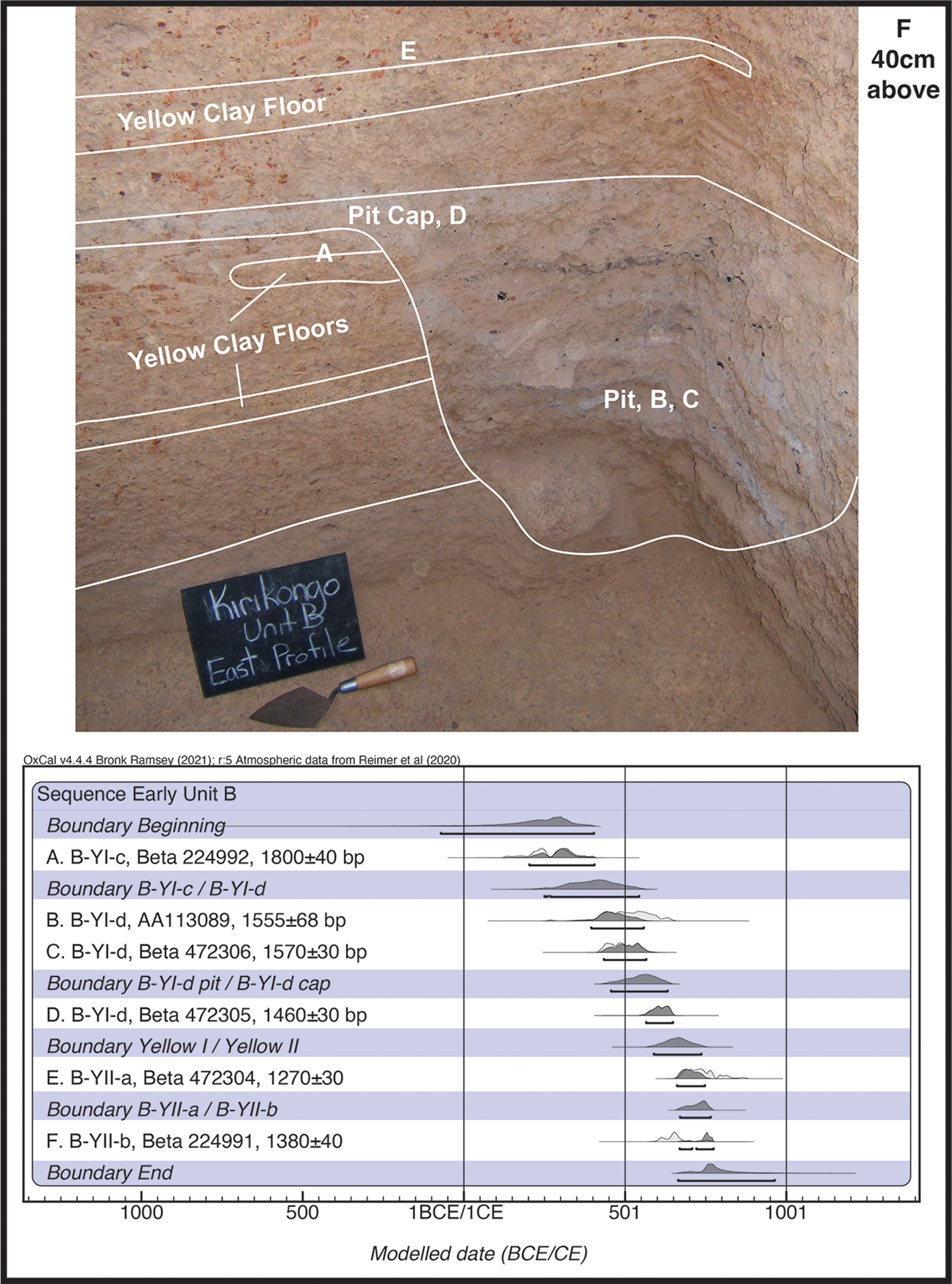
Figure 5. Annotated lower sequence (Yellow I–II) at Mound 4 with modelled AMS dates. Letters on profile mark deposits from which dated samples were obtained rather than the specific locations of sample collection.
At a certain point, perhaps the death of a notable individual, most domestic architecture at the site transitioned to mortuary monuments. Burials and accompanying ritual deposits occurred within or in association with houses and courtyards. These interments marked the end of domestic use and there is evidence that these locations may have been venerated over a period of time. In some cases, mortuary structures similar to those found in dedicated burial areas were constructed over levelled domestic architecture. Activity areas also may have been loci of mortuary structures, at least for the members of hereditary occupation groups (smiths/potters) who lived at Mound 11. During Red III in Unit E, a small structure was built over the remnants of a pottery kiln with an arrangement of pottery production tools and funerary depositions like those found associated with probable residential structures elsewhere at the site. Throughout the site, this cultural practice resulted in two strata related to an individual, one connected to a structure they utilized in life and one to their veneration as an ancestor.
As a first step when constructing new residential architecture and activity areas, the remnants of previous activity on the site (whether residential, mortuary, or activity) were levelled. In preparing the ground, residents left 20–30 cm of architectural foundations from previous structures in place and removed or recycled much of the architectural debris, leaving only enough to create a level surface. A foundation ritual deposit was emplaced, often shallowly dug into the remains of the earlier architecture, the newly levelled space was paved over and new architecture constructed.
The middle stratigraphic sequence from Unit A exemplifies the spatio-temporal process in which domestic spaces were converted to mortuary monuments, venerated and then reconverted to domestic space after a temporal gap (Figs 6, 7, 8). After a series of mortuary monuments at the end of Yellow II, with the last monument probably dating to the eighth century ce, there is evidence for a temporal gap. This was followed by construction of a thick flooring sequence with at least 7–8 repaving events that resulted in a 20 cm thick surface, which is a common feature of Red I occupation at the site. In the tenth century ce, the courtyard area constituting the southern half of the paved space was converted to a mortuary monument with a burial pit, adjacent ritual deposition and small mortuary house. Meanwhile, in the northern half of the excavation unit, a domestic structure with a grain-grinding platform remained in use. Eventually, in the eleventh century ce, this northern house was also converted to a tomb with a burial pit in the centre and adjacent ritualized depositions. It was partially sealed by a probably associated small mortuary house with a bowl inset in the centre of the floor. A few decades later, a foundation deposit was interred in the southern part of the unit over the earlier mortuary monument, the area was repaved and new domestic structures built. The northern mortuary house was left in place and probably continued to be venerated. The southern unit thus became available for new construction at least 80 years and up to 200 years after the interment below. The new construction and the northern mortuary house (which had continued to be venerated) were both abandoned in the mid twelfth century ce during a political revolution. Consistent with general stratification practices, once the space became occupied again in the late thirteenth century ce, foundation deposits were interred prior to repavement.
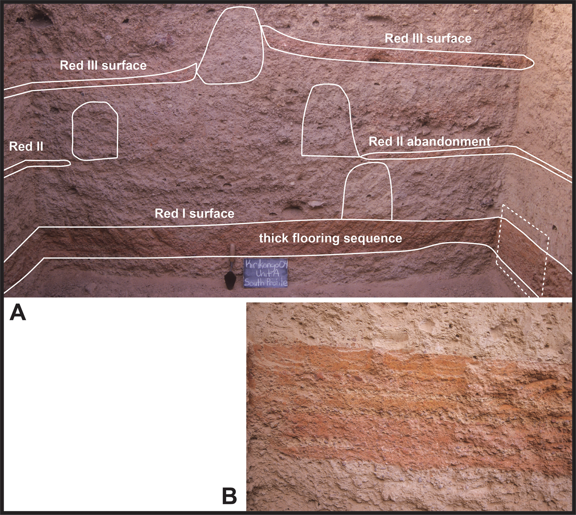
Figure 6. Unit A southern profile. (A) annotated Red I through Red III occupation layers; (B) laminated crushed laterite pavements detail from location indicated on A with dotted box.
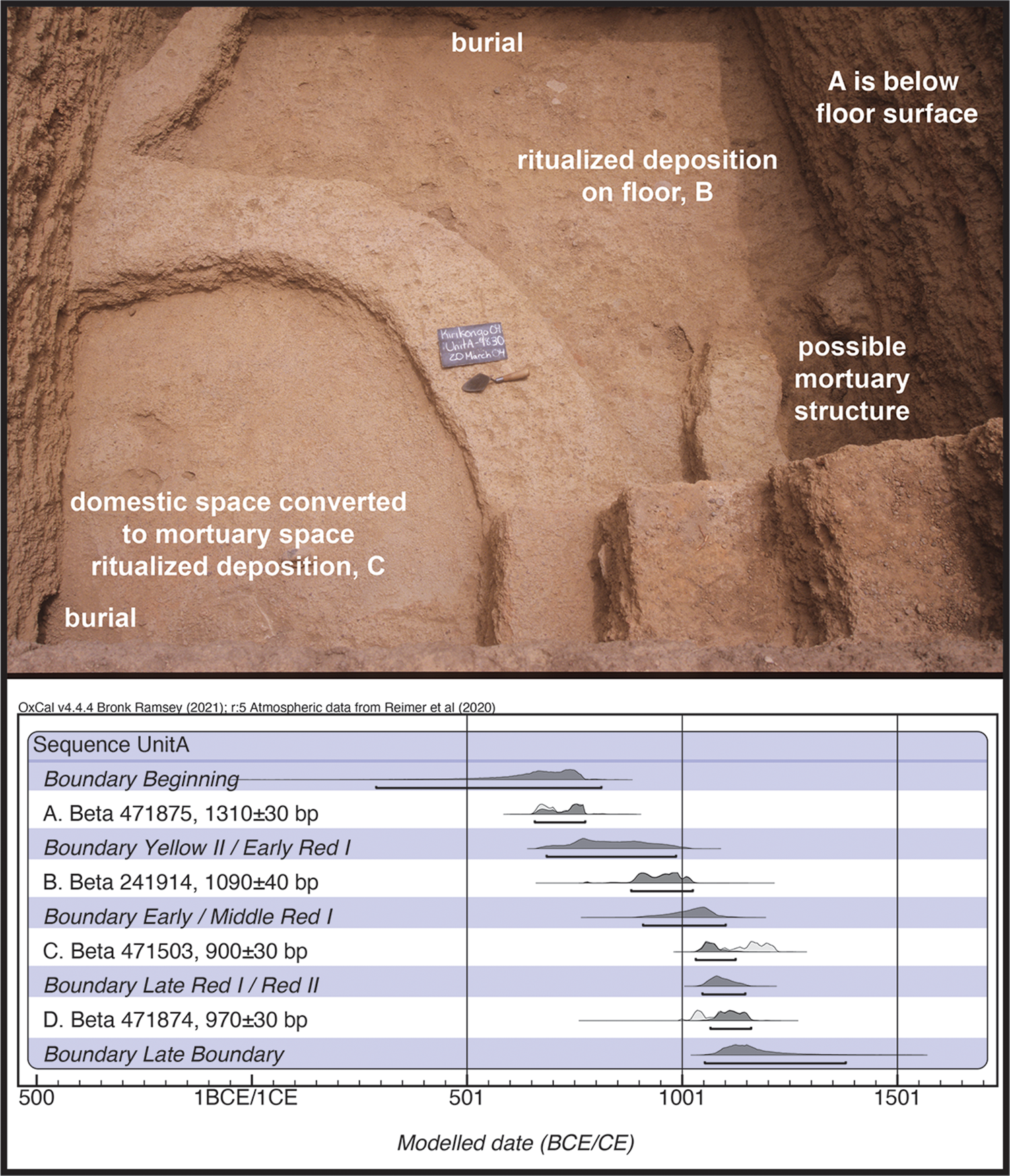
Figure 7. Annotated Red I architectural complex in Unit A, Mound 1 with modelled AMS dates. Letters mark deposits from which dated samples were obtained.
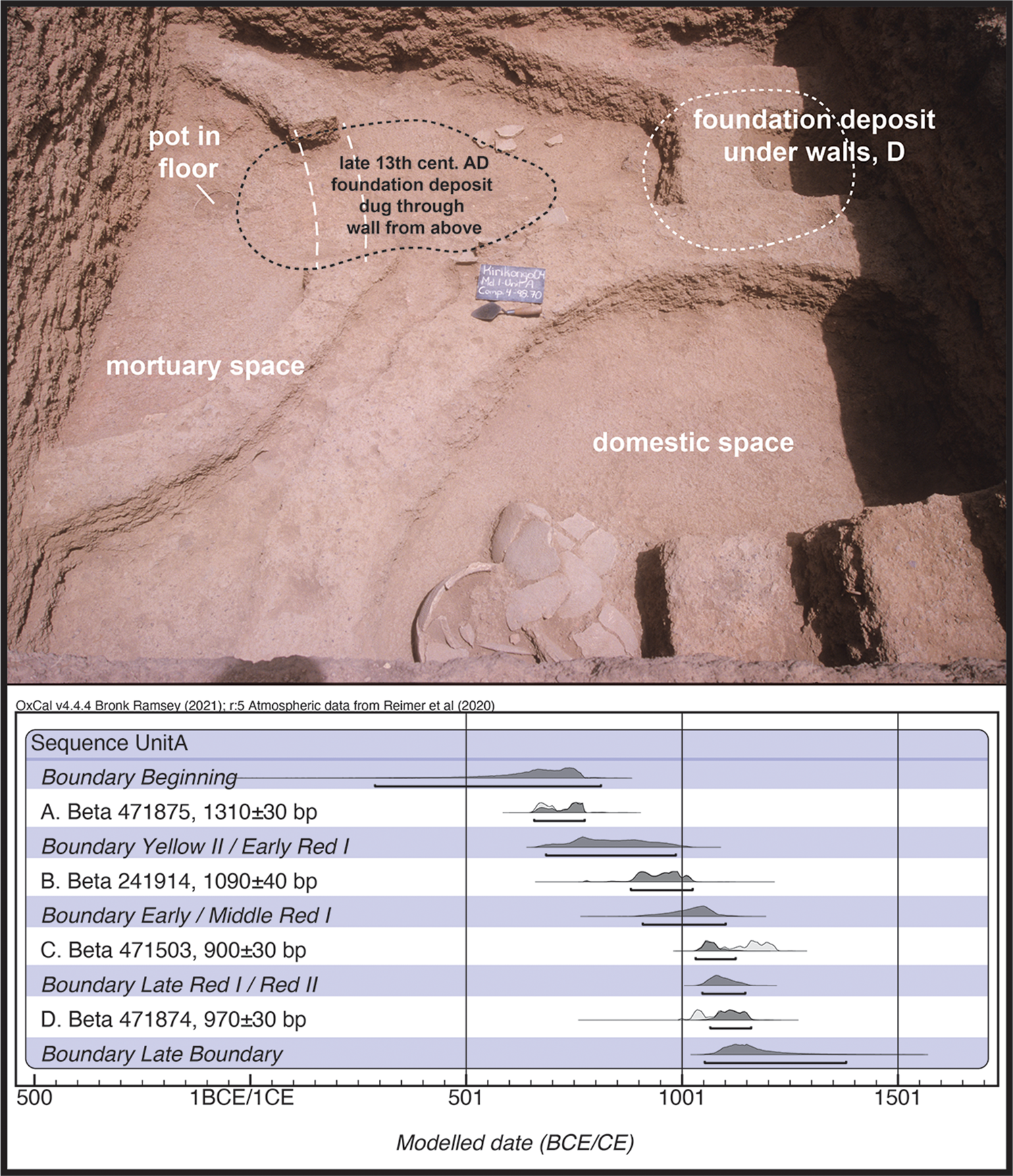
Figure 8. Annotated Early Red II architectural complex in Unit A, Mound 1 with modelled AMS dates. Letters mark deposits from which dated samples were obtained.
The twelfth- and thirteenth-century ce levels at Unit A also exemplify one of the rare cases of actual abandonment or catastrophic destruction at the site. In the mortuary house and the adjacent domestic structure, terrace roof fragments and walls collapsed into structures, crushing complete storage jars that had been left in place. The abundant architectural debris filled the structures, resulting in a homogenous interior matrix. No contemporary burials or ritual deposits were identified and, interestingly, there is no evidence that the space was used for trash disposal as ash, animal bones and material culture were largely absent, aside from the foundation deposit emplaced c. 150 years later prior to new construction. The few ceramics that were recovered from the fill were small, trampled fragments that were probably incorporated into earthen walls. The destruction of the ritual complex in Unit B at Mound 4 also differed from typical stratification at Kirikongo, as the burned roof collapsed into the structure, crushing and sealing in situ assemblages under burned beams and fragments of roofing pavement (fig. 9). As a result, at least 70 cm of the structure walls were preserved. A subsequent destruction level had similar formation processes, although the rebuilt ritual complex was less substantial.

Figure 9. Detail of south profile of Unit B, Mound 4 showing architectural collapse into burned structure.
Overall, mound formation at Kirikongo was a slow process. While in certain rare moments thick cultural layers were produced by abandonment or destruction, for much of the sequence this accumulation was the result of an intentional process that created cultural strata that were in active use for decades or more. The next stratum laid in a particular location seems to have occurred after some time, as radiocarbon dates and the relative ceramic chronology indicate gaps of at minimum 80–100 years between an interment that marked conversion to a mortuary space (often with a deconstructed structure and a newly constructed mortuary house) and the later commencement of a new construction layer. Interestingly, this timing aligns with Goody's observation in northern Ghana that ancestors in rituals are remembered as individuals for approximately three generations (Goody Reference Goody1962, 389; see discussions in Dueppen Reference Dueppen2022). It is possible that new construction only became possible in a place once the deceased had passed from active memory.
While excavation data from Kirikongo has provided rich insights into the mound-formation processes at the site, all excavation units were placed at the highest point of their respective mounds and their sequences therefore represent activities at central locations. Many questions remain. Are the mound formation processes observed in these units representative? Was trash ever disposed of on mounds? Did people live on different parts of the mound at different times? The road cuts at Kirikongo provide a unique opportunity to examine these questions from the perspective of a full mound cross-section.
Mound (tell) formation at Kirikongo: insights from road-cut mound profiles
Mounds 1, 2 and 8 were cut through during construction of Burkina Road #10 prior to the 1997 start of systematic archaeological research in the Mouhoun Bend, resulting in a unique opportunity to study the full cross-section of these mounds (Fig. 10). Although the edges of these cuts had eroded, the exposures remained near-vertical due to the preserved architectural foundations and pavements holding together deposits. In order to minimize further erosion of the deposits, the profiles were not cut back to a vertical face, but instead very lightly cleaned to increase visibility of features. Once the profiles had been drawn, diagnostic ceramics extruding from the profile were collected to provide reference points for the date of deposits (Fig. 11). These mounds were also surface collected as part of the systematic field research, providing supporting data for chronological assessments. For Mound 1, additional comparative temporal and spatial data are available from the nearby excavation Unit A.

Figure 10. Road-cut profiles at Kirikongo: (upper left) Mound 2; (lower left) Mound 1; (right) detail of Mound 2 showing ceramics resting on floors.

Figure 11. Examples of ceramics from Mound 2 road-cut profile used for dating: (A) Red I jar with flared decorated rim (Type 12: see Dueppen Reference Dueppen2012a, 137 for type description); (B) Red III jar with triangular rim (Type 30: see Dueppen Reference Dueppen2012a, 160 for type description).
Mound 2
This road cut extended for almost 60 m east–west along the northern tip of Mound 2 (maximum dimensions 86 m east–west, 96 m north–south), with architectural remains identified in a 24.3 m section corresponding to the highest part of the mound (Fig. 12). At the mound's peak, 1.7 m of cultural deposits were visible in the profile and datable pottery concentrations resembling those in excavations were found on a sequence of floors. From both the road-cut and surface collections, the occupation of Mound 2 spanned approximately 600 years from Red I to Red III. There was no evidence for Yellow phase deposits and there was a mid to late fourteenth-century abandonment layer on the surface.

Figure 12. Mound 2 road-cut profile showing distinguishable features.
The earliest identifiable features in the Mound 2 road cut were in a 5 m area in the eastern half of the mound. These included a structure RC2-1 with earthen walls and a thick, 2.6 m interior length laterite pavement floor. Assemblages of fragmented Red I pottery were against the western and eastern walls. To the east was a small 0.35 m earthen structure RC2-2 that strongly resembles Red I mortuary houses identified in excavation units at Mound 1 and 3, while to the west were two large laterite blocks. The next stratum was located 20 cm directly above this initial architectural complex and extended a little over 6 m. This included a 2 m pavement segment RC2-4 that shared a wall with a 4 m pavement segment RC2-5 to the west. While lacking pottery depositions, these probably date to either late Red I or early Red II. Also undated but possibly associated is a 1.6 m long floor of a structure RC2-3 found a metre to the east of the main architectural sequence. A laterite block rested on the structure. If associated, this structure would extend the occupied area in this stratum to a little over 9 m. The next layer contained RC2-7 and the adjacent RC2-9, with RC2-9 containing a ritualized deposition of Red II pottery.
In Red III, the occupied area of the mound expanded significantly to the west, extending to almost 21 m of the profile. Multiple structures were built 20 cm above the previous architecture. RC2-6 (1.3 m) had a ritualized deposition of early Red III pottery, while the adjacent RC2-8 to the east of RC2-9 had an in situ abandoned Red III assemblage in the west. The sloped floor seemingly connecting RC2-8 and RC2-9 may be the result of compaction from modern road construction. Moving to the west, the Red III floors in the centre of the mound have a slight downward slope, perhaps a result of having been built on the softer unconsolidated talus slope deposits of the earlier occupations (see discussion below). The 1.7 m, 10 cm thick floor of RC2-10 sloped 10 cm, the small RC2-11 floor was fairly flat and the nearly 3 m of 3–5 cm thick RC2-13 floor sloped 20 cm. A thick, disarticulated bow-shaped section of pavement RC2-12 on top of RC2-11 resembled the jumbled roof collapse found in an abandoned structure in Unit A and may indicate that the structure was left to decay late in Red III. RC2-13 contained a ritual deposition that dated to Red III and a small floor RC2-14 directly above it (possibly a mortuary structure) also contained ritual depositions of Red III pottery. A metre to the west, a 50 cm thick earthen wall segment RC2-15 separated the final Red III architectural unit from the other Red III structures. A pottery concentration dating to Red III was identified to the immediate west of the wall, 80 cm to the east of the 3.2 m long RC2-16. The smaller 1.3 m RC2-17 was constructed 12 cm above RC2-16's western edge after its abandonment, presumably in Red III.
To the east and west of the preserved architecture were slopes composed of a soft and unconsolidated mix of architectural melt, ash and pottery fragments. Visually, artifacts were evenly distributed within the matrix and, unlike ritual deposition locations in the centre of the mound, they contained no animal bones. To the east, 27 m of low gradient mixed fill extended into a plaza between Mounds 2 and 8, while to the west, a steeper 6 m gradient extended towards the edge of the seasonal drainage. Given the stratification of the mound, it is highly likely that most of the talus slope material in the west dates to Red II and III, since the talus slope for earlier deposits was overbuilt as settlement expanded.
Mound 1
This road cut extended for 70 m along the southern edge of the irregularly shaped Mound 1 (150 m maximum diameter east–west and north–south), with architectural remains identified in a 30.4 m section corresponding to the highest section of the mound (Fig 13). At the mound's peak, 2.15 m of cultural deposits were visible in the profile. Based on excavations in Unit A, approximately 10 m north from the road cut, an additional 1.15 m of cultural deposits were not visible. Unlike the Mound 2 section, exposed flooring sections and features did not have in situ datable ceramics. Interpretation of the relative sequence and temporal association of structures in this profile was further complicated by several large pits that cut through earlier deposits, as well as spatial gaps between individual structures. However, based on flooring methods, architecture and stratigraphic alignment with nearby Unit A deposits, it was possible to determine that the exposed sections dated to the Red phase of occupation, with the basal architectural layers probably RI/RII and upper sections from Red III/early Red IV.

Figure 13. Mound 1 road-cut profile showing distinguishable features.
Five structures, which may or may not have been in use simultaneously, are located near the base of the road cut and stratigraphically predate other features. RC1-1, located near the centre of the mound, is a 2.7 m long, 12–15 cm thick pavement that was clipped by later pits on both ends. It is unknown if a superimposed structure was constructed above, as a short pavement section present on top of the west side of the structure could have been either a new structure or a roof pavement from abandonment. To the east, RC1-2 is a similar 2.9 m long, 10–12 cm thick pavement that lapped up against a wall in the east and stopped about 10 cm short of a wall to the west that may be associated with a later structure. The very thick floors in RC1-1 and RC1-2 are similar to both the initial Red I laterite pavements in Unit A as well as the thick floors associated with Red I pottery in the Mound 2 road cut. This seems to have been a common practice when building over the softer, less consolidated Yellow phase deposits and in foundation layers more generally.
The three other early structures do not share this same pavement thickness and have floors that are generally around 5 cm thick. They could be slightly later construction, used for different purposes, or simply in use for less time. To the east, RC1-3 has a preserved wall at its western edge and has been cut by a later pit in the east. This could be associated with conversion to a mortuary monument. To the west, RC1-8 is a 2.3 m pavement with an intact eastern wall. The remnants were left intact, ash was deposited on the interior and a new 0.6 m floor segment RC1-9 was constructed 12 cm above the original floor. This could be associated with conversion to a mortuary monument. Finally, RC1-4, the westernmost feature identified in the mound, is a 2.3 m pavement on which the bases of two ceramic vessels rested.
Five structures were built approximately 20–40 cm above this basal group of structures. Like the first group, they are distributed across the mound and their temporal relationship to each other is not always clear. Beginning in the west, RC1-5 and RC1-6 share a wall. The former is a 2.1 m pavement located directly above RC1-4, while the 3.2 m pavement RC1-6 ends just above the edge of the earlier RC1-8 pavement. A slight concavity filled with ash and burned earth directly below the eastern edge of RC1-6 may be a foundation deposit. Upon abandonment of RC1-6, the 1.9 m pavement RC1-7 was constructed 20 cm above its western half. This may be a mortuary structure associated with conversion to a mortuary monument or the edge of a later, larger structure built further to the north or south. Eight metres to the east, there is a small section of pavement RC1-10 cut by a pit which shares a wall with a very small paved space RC1-11 of unknown function to the east. A foundation deposit with ash above the floor in the east of RC1-1 on the other side of the pit may be associated with these features. Further to the east, the 1.5 m pavement RC1-12 extends over the wall of the earlier RC1-3 and a deposit of ceramics against its eastern wall may be a ritual deposit. Its eastern wall may have collapsed outward, and it is possible that the small irregular pavement section to the east of the collapse was part of a terrace roof.
Given the lack of chronological resolution, interpretation of the early Red (probably Red I–II) use of space on Mound 1 is challenging. Collectively, these structures extend over 21.7 m of space, the entire area of which was probably paved at some point during this occupation. It is possible that these structures are elements of a large compound(s), which matches evidence from similar depths in Unit A. The 80–100 cm above these structures also strongly resemble the latter sequence from nearby Unit A, where the excavated area was abandoned from mid Red II (middle twelfth century) to the late thirteenth century (Red III), before a quick deposition of a metre of deposit over the course of the fourteenth and first decade of the fifteenth century.
The majority of features post-dating the structures described are large pits and concentrations of ceramics. The lack of architecture could be a result of different activities in this part of the mound, or the architecture may be less visible, as in Unit A late architecture had less consolidated walls and much thinner floors. Two large ash pits RC1-13 and RC1-14, potentially dating to Red III, originate around 30–60 cm above the latter group of structures. RC1-13 cuts through the deposits while RC1-14 terminates on the very thick floor of RC1-2. Almost 3 m to the east of the earlier structures is the final structure visible in the road cut. While it is possible that RC1-15 is associated with the second group of structures, it is in closer stratigraphic alignment with the large pits. This structure was built over a burial and had diverse ceramics, probably from a ritual deposit on its floor. Directly outside the structure were two laterite blocks and more ceramics. It is possible that the burial was a foundation mortuary deposit in this area of the mound, as it was previously unoccupied. Finally, there is a large pit RC1-16 at the peak of the mound that extends almost to the surface (Red IV based on surface collections), and a few large ceramics just below the surface could be associated with very late structures. In Unit A, the last floors, located 30 cm below the surface, were very ephemeral and had a few large ceramic sherds resting on them.
The talus slopes of Mound 1, like those of Mound 2, contained no features and were composed of a soft and unconsolidated mix of architectural melt, ash and pottery fragments. They extended over 20 m in each direction from the central occupied area. The area to the east of the mound was razed during road construction, impacting the talus slope, while a dirt road going north to the community of Kirikongo bounded the western edge.
Mound 8
This road cut extended for 70 m probably through the northern third of Mound 8 (maximum diameter 82 m east–west, 50 m north–south), with architectural remains identified in a 14.5 m section near the centre of the mound (Fig. 14). Its maximal height at the exposure was 1.3 meters. Like Mound 1, while several floor and wall segments were identifiable, they did not have clearly datable ceramics associated with the exposed sections. While there is no comparative excavation data from Mound 8, surface collections suggest that it was occupied from late Red II to Red III with a fourteenth century abandonment layer on the surface. This is consistent with the Red phase architecture observed in the road cut.

Figure 14. Mound 8 road-cut profile showing distinguishable features.
The earliest visible feature, RC8-1, was a 3 m very thick (more than 16 cm) laterite pavement. It is possible that, as is the case for floors of this thickness at Mounds 1 and 2, this floor dates to Red I. However, there is no other evidence for Red I occupation at Mound 8 and it may be that very thick laterite pavements are associated with initial Red phase occupation of new areas of the site, regardless of when it occurred. No other floors were in direct association with this floor, nor did any other structures in the Mound 8 profile have floors of the same thickness.
Three structures may either be contemporary with or post-date RC8-1. Just over a metre to the east, a 1.7 m long thin pavement RC8-6 was bounded on the east by a wall stub. Three-and-a-half metres to the west, the adjoined RC8-7 and RC8-8 had slightly thicker 6–8 cm floors. These two structures were bounded by thick walls (40 cm in the east, 95 cm in the west) and shared a thinner (20 cm) interior wall that separated what, at this point, was the larger 2.4 m RC8-7 from the 1 m RC8-8. Finally, there is a cluster of four 1 m pavements (RC8-2 through RC8-5) 20–40 cm above RC8-1. Given their close spacing, they were almost certainly of small size, as there would not be enough east–west space between them to increase their diameter to the north or south of the road cut. These may be mortuary monuments and the westernmost, RC8-5, had a large ceramic sherd floating just above the floor.
The talus slopes of Mound 8, like those of Mound 2, contained no features and were composed of a soft and unconsolidated mix of architectural melt, ash and pottery fragments. In a few cases, there are higher concentrations of sherds in the Mound 8 talus slopes, perhaps representing a more recent trash deposition at the point of abandonment. The talus slope to the west of the architecture extends 31 m towards a plaza with Mound 2 and that to the east extends 24 m towards an open space extending ultimately to Mound 10.
Stratification processes
The stratification processes in the road cut profiles strongly resembled those found in excavation units. In both cases, architectural levels were often separated by 20–30 cm and wall foundations were often preserved at that height. Ritual depositions were commonly emplaced below new structures (e.g. RC1-6) and in converted residential structures (RC2-9). While it is difficult to assess the size of circular structures definitively from a vertical cut through them, the repetition of smaller-sized pavements and structures above larger-sized structures (e.g. RC2-16/RC2-17; RC1-8/RC1-9; see Table 2) closely resembles data from excavation units for the creation of smaller mortuary houses (usually slightly offset) after the ritualized transformation of domestic architecture. It is likely that during at least the Red phase mortuary houses, regardless of whether they were built over ritually converted domestic architecture or adjacent to residential space, were integrated within actively occupied areas of the mound.
Table 2. Superimposed features in Kirikongo road cut profiles.

The temporality of the stratification process (life cycle), whereby a house was lived in, levelled to a foundation and topped with a mortuary house, and then maintained for at least 80 to 100 years, was also generally validated in the road cuts, particularly at Mound 2, where ritualized depositions of ceramics were available on many floors. These indicate that, within the core of the mound, only a few residential layers were created during ceramic sub-phases lasting centuries, as a particular space was lived in and then ancestors venerated in a spatially centred process before being ritually transitioned into a living space again. These slow stratification processes in any given location may have helped contribute to the extensive growth of mounds horizontally and been responsible for the fairly constrained pace of vertical growth of mounds over time in relation to calendar years.
Distinguishing middens and ritual deposits
Data from the road cuts strengthen Dueppen's (Reference Dueppen2022) argument that deposits of fragmented material culture, animal bone and ash from occupied areas of the mound resulted from ritual practices rather than trash disposal by providing both a location for and comparative data from midden deposits. As described above, excavation units contained few to no deposits that resembled a midden, and even the abandonment layer in Red II at Mound 1 contained only architectural collapse. This was also the case in the road cuts, where pits and ashy areas within the architectural space shared the same qualities as the ritualized pit deposits identified during excavation (primary deposition of pottery fragments, and purposeful deposition in relation to features).
In contrast to the architectural space, the edges of mounds contained large areas where homogenous ashy clay deposits and/or broken pottery fragments were located. Talus slope deposits were distinct from the ritualized depositions in a number of ways, and their nature reflects the constant circulation of materials within mounds over time. As is true of ethnohistoric practices, materials on the talus slope were likely to have been churned over time with the continual deposition of new materials (including both waste and debris from intentional leveling of architecture), digging of borrow pits to create new earthen construction materials, and impact of daily activities such as trampling. It is this highly processed material that was used for new constructions over time and that is identified around architectural remnants and ritualized depositions (Fig. 15). For example, in excavation, coursed earth and earthen brick contained small eroded sherds probably drawn from the talus slopes and, as a result, older decoration techniques were continually present in low quantities. For example, diagonal mat impressions, which ceased use in the 14th century, are found on 9.7 per cent of 2067 body sherds in Red IV deposits (1400–1500 ce), and alternate braided strip roulette, which was used prior to 700 ce, was identified on 2.1 per cent of Red III (1200–1400 ce) body sherds.

Figure 15. Schematic model of the relationship between domestic contexts and talus slope deposits at Kirikongo mounds.
In more processed areas of the talus slopes, these processes not only created a homogeneous diverse matrix of largely smaller ceramics and even distributions of clay and ash; they also probably contributed to the poor preservation of fauna, which was virtually absent from talus slope deposits. Fauna in midden deposits may also have been chewed by dogs at the time of disposal, and/or it is possible that rich kitchen waste was preferentially carried to fields for use as fertilizer.
A less developed example of a talus slope deposit may be present in the more briefly occupied Mound 8 road cut, where a more recent midden deposition on the talus slope contained larger fragments of ceramics in a more concentrated area. Had occupation of the mound not been interrupted by the Black Death pandemic, the talus slope might have become more mixed.
Architecture and use of space on mounds
Road cuts provided insights into the extent of occupied mounds, although extrapolating from the revealed profiles is complicated by both the position of the road cuts near the edges of mounds (such that talus slopes are a higher percentage of the profile length than they would be in a cut through the centre) as well as the evidence that the width and location of the talus slope can vary significantly within a mound. This is most notable at Mound 2, where there is a 27 m talus slope in the east and a much shorter 6 m talus slope in the west, a discrepancy due in part to the expansion of occupation over earlier talus slope deposits. However, on a very general level, it is likely that 50–75 per cent of the area of a given mound was occupied at a particular point in time.
The road cuts also provided significant data on the growth and depopulation of the site over the course of the Red Phase. In Red I and II, occupied areas within the road cuts is around one-third the maximal extent of the occupation, and it is notable that there appears to be a commitment to rebuilding in the same locations, a pattern that is most visible in Mound 2. In Red III, the occupied areas expand rapidly and spread into previously unoccupied parts of the mounds. Although this expansion is accompanied by a decrease in density (see discussion below), more architectural units are present and it proably reflects population growth. For example, in Mound 2, settlement seems to have expanded to two or three adjacent room blocks. Finally, the abandonment layers at Mounds 2 and 8 date to the mid to late fourteenth century, with intact pots in place in abandoned (not ritually deconstructed) structures at the top of Mound 2. At Mound 1, abandonment is slightly later, at the cusp of the fourteenth and fifteenth centuries, with minimal evidence for structures in the late sequence, consistent with the more poorly built and widely spaced architecture identified in excavations at this time. Given the extensive occupied space just prior to this era, the road-cut data provide evidence for what may have been a significant loss of life associated with the Black Death pandemic (see Gallagher & Dueppen Reference Gallagher and Dueppen2018).
Data from the road cuts also substantiated several more specific hypotheses about changes in the built environment at Kirikongo. In the excavation units, Red I and Red II deposits were characterized by tightly spaced architecture that appeared to be adjacent cells within larger well-paved and well-maintained compounds. A large circular compound wall was identified in Unit B that probably dated from Red I and early Red II; based on the curvature of the 2 m section in the unit, the compound may have been 30–50 m in diameter. In Unit A there was evidence within compounds for activity areas both inside structures and in interior courtyards, notably an interior grinding bench in Red I and early Red II structures. The road-cut profiles at Mounds 2 and 1 indicate that closed paved compounds were found throughout the community in Red I and Red II. Closely spaced rooms with shared walls were common and architecture was densely packed in specific areas of the mounds.
Starting in Red III, while the same architectural techniques remained in use, there is evidence that structures were more spaced out and several elongated connecting walls were found in excavation. Non-paved activity areas became more common, and some activities that had been on the interior, such as grinding, moved into these more open locations. A shift in spatial syntax in Red III was most clear in the Mound 2 profile where, in addition to the expansion of occupied space, paved areas became less dense and unpaved spaces more common. Mound 8, which only dates to the later period, has possible evidence for more distributed architecture, and larger walls that may suggest delineated room blocks. A shift in architectural syntax is also visible at Mound 1 despite the obscuring of deposits by probable fourteenth- and fifteenth-century pandemic-era pits, as these do not cut through densely distributed structures as in lower layers.
Ancestors and the living: co-residence, attachment, detachment and remembrance
Mound-formation processes at Kirikongo do not match well with the expectations of stratification models based on the life-cycle of earthen architecture in which degraded structures are filled with middens. Rather, the mounds at Kirikongo were composed of sequential domestic structures transitioned to houses of the dead, dedicated spaces (and mounds) solely composed of stratified houses of the dead, and activity areas where remnants were purposely left in situ. All were accompanied by ritualized depositions. Temporally, at a particular moment of time, some domestic structures were likely to be occupied adjacent to mortuary houses, indicating co-residential relations between the living and particular recent ancestors. The foundations of the mortuary houses were themselves later left intact when new architecture was constructed. This transition may have been associated with the cessation of individualized veneration, with the preservation of the foundations of structures linked to a transition to a more generalized ancestral status.
A deeper examination of why architectural foundations were left in situ for domestic and mortuary structures requires contextual analyses (e.g. Antczak & Beaudry Reference Antczak and Beaudry2019; Hodder Reference Hodder2012; Robb Reference Robb2015; Watts Reference Watts2013) of the relational associations of the other contents of ritual depositions that the architecture serves to structure spatially. As explored in detail elsewhere (Dueppen Reference Dueppen2022), at Kirikongo architectural remnants are part of a broader category of ritual deposition associated with the creation of ancestral emplacements. These deposits combined the remains of funerary feasts (including wild animals and sacrificed domestic animals), symbolic parts of wild animals and purposely fragmented or modified locally produced material culture. Non-fragmented material culture in these emplacements were materials not produced locally (long-distance trade items), unmodified natural objects (polished stones), or found objects (powerful objects) from the Neolithic. Under this logic, the fragmented architectural foundations are consistent with the treatment of other locally produced objects.
Drawing from extensive analyses of ethnohistoric practice (see Dueppen Reference Dueppen2022), the condition, nature and patterning of material culture reflect widespread beliefs in the Voltaic region of the ‘inclusive unity’ (e.g. Goody Reference Goody1962, 200) of people and material culture produced or used by individuals. Variations on these beliefs are commonly found in diverse ethnohistoric funerary traditions that incorporate the breaking of material culture (De Carbo Reference De Carbo1977; Goody Reference Goody1962; Saako Reference Saako2017; Smith Reference Smith1989), as well as other moments of life transition, such as the breakage of pottery upon divorce (Cremer Reference Cremer1924). Architecture as a creative process is like other material culture, and masons in some settings (see for example Pecquet Reference Pecquet2004) need to detach ritually from the buildings they construct in order for them to be used by others. Consequently, architectural remnants and pieces of purposely fragmented or modified material culture (representing an incomplete object) could materialize the continued attachment of ancestors in a new status (with continuing social role), while the breakage of the material culture detaches them from their living status (and allows aspects of the soul to travel to the land of the dead). If this argument is correct, residents of Kirikongo were in co-residence with both the living and named (remembered) ancestors, who were actively venerated, while spatially anchored by a broader community of ancestors underneath.
Ancestors, houses and dynamic histories
This paper has emphasized the continuities in ancestor-related mound-formation processes seen in the road cuts and excavations. However, Kirikongo was a dynamic community in which ritual practices, anchored identities, spatial logics and ancestral connections were continually renegotiated, reinterpreted and reenvisioned. The strong house identities materialized in spatially segregated mounds (with closed architectural compounds) served as a basis for the centralization of power by the founding house in the first millennium ce and provided a social foundation for resistance and reinvention of political dynamics in the twelfth-century egalitarian revolution.
The post-revolution period saw the maintenance of mound occupation but a change in spatial syntax to more open architectural forms and newly shared material culture produced by specialists not controlled by the founding house. This shift brought Kirikongo closer to the community-related practices documented in ethnohistoric settlements in the Voltaic region, where ancestors continue to be important anchors to social groups, but where social membership is more diverse and social relations cross-cut houses to create a collective identity (see discussions in Dueppen Reference Dueppen2012a,Reference Dueppenb; Reference Dueppen2019a,Reference Dueppen, Currás and Sastreb on kinship in multi-family houses). It is this social flexibility materialized in changing ancestral rituals that may have enabled the community to bridge the Black Death pandemic of the fourteenth century. By the early fifteenth century, only Mound 4 and part of the specialist blacksmith/potter Mound 11 were still occupied, although some parts of Mound 3 and Mound 7 were in use for industrial activities. It is possible that the remaining members of the abandoned mounds inhabited by farmers (including Mounds 1, 2 and 8) combined at the oldest house at Kirikongo, resulting in some of the most elaborate mortuary ritual deposits in the history of the site as the members created a new anchored identity.
Comparative perspectives from West Africa
Mound-formation processes at Kirikongo are likely to represent a particular cultural interpretation of socio-spatial dynamics sanctified by ancestral beliefs with co-residence of the ancestral and living communities. We would not expect the results from Kirikongo to apply holistically to the formation of mounded sites and non-mounded sites in other parts of West Africa. However, here we provide a few selected examples of how the general patterns observed have significant implications for the interpretation of sites in the region, both in regard to recognizing mortuary architecture and/or the transformation of domestic spaces into durable markers for ancestral relationships.
Some of the earliest mounds in West Africa are found in the second millennium bce Neolithic Kintampo culture in Ghana (e.g. Ntereso, Daboya) where stratified remains of probably deliberately burned wattle-and-daub houses were associated with ritualized pit depositions of fragmented material culture and funerary feasts (see discussions in Casey Reference Casey2000; Davies Reference Davies1973; Dueppen Reference Dueppen2022; Sawatzky Reference Sawatzky1998; Shinnie & Kense Reference Shinnie and Kense1989). The emphasis on enduring durability of earthen structures through ritualized burning could suggest similar ancestral beliefs related to maintaining attachments. Ritual depositions of fragmented materials are also well documented several thousand years later in northern Ghana, where in the late first and early second millennium ce societies created diverse mound types including house mounds with burials and ritual mounds that include, among other fragmented material culture, broken terracottas (Kankpeyeng et al. Reference Kankpeyeng, Swanepoel, Insoll, Nkumbaan, Amartey and Saako2013; Kankpeyeng & Nkumbaan Reference Kankpeyeng, Nkumbaan, Magnavita, Koté, Breunig and Idé2009; see also Stahl Reference Stahl, Mills and Walker2008, for central Ghana).
Perhaps the most famous region of mound sites in West Africa is the Inland Niger Delta, where hundreds of clustered mound sites ranging from urban centres to small communities are located, some of which are still inhabited today. At one of these sites, Jenne-jeno, the earliest (Phase I/II) deposits contain burnt daub and pits (S. McIntosh Reference McIntosh1995), with potential similarities to the Kintampo pattern as well as early ritual pits at Kirikongo. Early second-millennium ce deposits included architectural remnants in excellent condition with short preserved wall stubs, notably a blacksmith's house in association with ritualized terracotta inclusions (S. McIntosh Reference McIntosh1995). Interpreted as a household shrine, it is possible that it represents ancestral ritual or even the conversion of lived space into mortuary monuments. Moreover, surface surveys of the Inland Niger Delta have identified many small-sized structures made using diverse architectural techniques and occasionally surrounded by funerary urns (see Clark Reference Clark2003). While these smaller structures have tended to be interpreted as granary foundations, fish-smoking installations, or as relating to other industrial uses, we suggest that some, in particular those located in mortuary areas, may be related to funerary or ancestor rituals.
While ancestral rituals are central to understanding mound formation at Kirikongo and probably other mounds in West Africa, it is clear that ancestor-related ritual practices and site creation are not solely associated with mound formation. For example, the famous Senegambian megalithic monuments of the first and second millennia ce have been reinterpreted not as stone circles, but rather as houses of the dead made of durable materials (laterite) (Holl & Bocoum Reference Holl and Bocoum2017; Holl et al. Reference Holl, Bocoum, Dueppen and Gallagher2007; Laporte et al. Reference Laporte, Bocoum and Cros2012). Accompanied by ritual offerings, the complexes of these monuments are likely to have served as regional anchors for communities that moved intergenerationally. As a result, residential sites in the region tend to be more ephemeral (see Lawson Reference Lawson2003), while the megalithic sites endure.
Close to the Mouhoun Bend, the creation of small clay mortuary houses for ancestors in rockshelters in Bandiagara may also serve as spatial anchors for relationships with ancestors across broader areas (Mayor et al. Reference Mayor, Huysecom, Ozainne and Magnavita2014). In some parts of central and eastern Burkina Faso, generational mobilities in which individual households moved at least every few decades while elite houses were more spatially durable created a landscape with widely dispersed thin sites, and some possibly more substantial areas, among them royal tomb sites (Gallagher Reference Gallagher2021; Thiombiano-Ilboudo Reference Thiombiano-Ilboudo2010). Comparison to these non-mound contexts further illuminates our argument that the mounds of western Burkina Faso reflect not simply ritual related to ancestor veneration, but rather a strong interpretation of co-residential relationships between the living and ancestral communities of all houses in society.
Archaeological tells
One of the fundamental and enduring questions of tell formation worldwide is why inhabitants left architectural remnants in place when rebuilding in the same location and what meanings can be discerned from these choices. As demonstrated throughout this paper, earthen architectural remains at Kirikongo do not conform well with a site-formation process of build-up by abandonment, collapse and midden deposition prior to new stratification. Rooted in ontological beliefs of ancestors, houses, material culture and divinities, mounds in the Mouhoun Bend region situated the multi-temporal community and provided a historically situated foundation for strong house identities, and probably for resistance to centralization.
At Kirikongo, mound formation was centred on strong co-residential relationships with ancestors. This resulted in slow stratification processes, since a space could only be built upon after the life of an individual (domestic structure) and the active memory (venerated mortuary house) had faded. Mounds had a ritual core, but entire mounds were probably sanctified through material historical connections and talus slope deposits were re-circulated into later constructions. It is likely that these ancestral practices influenced the creation of mound clusters, as individuals and social groups negotiated identities within multi-temporal dialogues tied to particular places.
Through a focus on understanding site-formation processes, the mounds of the Mouhoun Bend region of West Africa contribute new perspectives to recent advances in tell research worldwide by unpacking complex cultural beliefs of the relations between people, architecture, material culture more broadly and ancestor rituals. These call into question implicit passive interpretations of the cultural processes leading to architectural remnants in sites and midden interpretations of depositions in architectural remnants, and opens up understanding of the multi-temporal nature of decisions that created tells. Employing contextual approaches to the analysis of West African mounds enriches understandings of the people that inhabited them and calls for reassessments of historical practices that form these important archaeological sites.
Acknowledgements
Funding for the research at Kirikongo was provided by a National Science Foundation Dissertation Improvement Grant (BCS-0520614), a Smithsonian Institution Predoctoral Fellowship at the National Museum of Natural History (Archaeobiology Program), an Africa Initiative Research Grant from the Center for Afro-American and African Studies at the University of Michigan, an American Council of Learned Societies New Faculty Fellowship, an Institute for Cognitive and Decision Making Sciences Grant (University of Oregon), an Oregon Humanities Center Faculty Fellowship and additional support from the University of Michigan and the University of Oregon. Understandings of tell formation at Kirikongo were also informed by subsequent fieldwork at neighbouring sites funded by a National Geographic Society for Research and Exploration Grant (8849-10).
In Burkina Faso, research was made possible through the extensive support of Lassina Koté (Université Ki-Zerbo, Ouagadougou). We appreciate his encouragement, advice and logistical support over the years. Koté oversaw the construction of the local museum in Douroula where the materials from archaeological projects in the Mouhoun Bend region are housed, and he curates these important collections. Research permits for fieldwork at Kirikongo and surrounding sites were issued by the National Center for Science and Technology (CNRST) of Burkina Faso, and we thank Vincent Sédogo, Eloi Bambara and Moussa Ouadraogo for their support. Export permits for botanical remains and animal bones were issued by the Ministry of Culture, under the direction of Oumarou Nao and then Jean-Claude Dioma.
In the Mouhoun Bend region, we thank the communities of Douroula, Tora and Kirikongo for their hospitality, and we acknowledge the significant contributions of Drissa Koté, Abdoulaye Koita, Amadou Koté, Haruna Sankara and Madelaine Taro to our research. Former University of Ouagadougou students, Léonce Ki participated in the excavations at Kirikongo and Fabrice Dabiré at surrounding sites, and we appreciate their hard work and dedication. Alethea Steingisser in the Infographics Lab at the University of Oregon Geography Department produced the regional map (Figure 1). Finally, we thank the anonymous reviewers for their thoughtful comments on this work.


