


List of Symbols
APFL Climatic alpine pine-forest limit, Atlantic period
PPFL Climatic alpine pine-forest limit, present
gA Topographic gradient of mean summer temperature in atmosphere of Atlantic period
gAE Topographic gradient of mean summer temperature in atmosphere of Atlantic period, east side
gAW Topographic gradient of mean summer temperature in atmosphere of Atlantic period, west side
gp Topographic gradient of mean summer temperature in present atmosphere
gPE Topographic gradient of mean summer temperature in present atmosphere, east side
gPW Topographic gradient of mean summer temperature in present atmosphere, west side
hA Height of climatic alpine pine-forest limit during the Atlantic period
hAE Height of climatic alpine pine-forest limit during the Atlantic period, east side
hAW Height of climatic alpine pine-forest limit during the Atlantic period, west side
hp Mean height of present climatic alpine pine-forest limit
hPE Mean height of present climatic alpine pine-forest limit, east side
hPW Mean height of present climatic alpine pine-forest limit, west side
hS Height of watershed
hE Height, east side
hW Height, west side
PAE Point on mean summer temperature curve for Atlantic period, east side (Fig.6)
PAW Point on mean summer temperature curve for Atlantic period, west side (Fig.6)
Δh = hA − hP, difference between Atlantic period and present climatic alpine pine-forest elevation
ΔhE = hAE − hPE, difference between Atlantic period and present climatic alpine pine-forest elevation, east side
ΔhW = hAW − hPW, difference between Atlantic period and present climatic alpine pine- forest elevation, west side
τ Mean summer temperature, i.e. the mean temperature for June, July, August and September (“tetraterm” in Norwegian)
τS Mean summer temperature at the watershed
τP Mean summer temperature at optimal climatic alpine pine-forest limit
τPE Mean summer temperature at optimal climatic alpine pine-forest limit, east side
τPW Mean summer temperature at optimal climatic alpine pine-forest limit, west side
ΔτA Difference in mean summer temperature of east and west sides, Atlantic period
ΔτP Difference in mean summer temperature of east and west sides, present
ΔτE Difference between mean summer temperature of the Atlantic period and present, east side
ΔτW Difference between mean summer temperature of the Atlantic period and present, west side
ΔτS Difference between mean summer temperature of the Atlantic period and present, at watershed
τE Mean summer temperature, east side
τW Mean summer temperature, west side
1 Introduction
The post-glacial climatic optimum is well-documented in Scandinavia. Evidence of this warm period in western Norway is based mainly upon studies of vegetation history by pollen analysis (Reference FæsgriFægri 1940, Reference MoeMoe 1977). Climatic interpretation in terms of mean temperatures of the Atlantic period usually refer to lowland areas, and yearly and summer mean temperatures of 1 to 2°C above those of the present are frequently mentioned (see, for example, Reference LambLamb 1977).
In our study we present some quantitative estimates of mean summer temperatures in the mountain area between Suldal and Setesdal in south-west Norway (Fig.1). These estimates are based upon the interpretation of the presence of old pine stumps and trunks above the present pine-forest limit, which, we believe, represents a higher pine-forest limit. We assume that moisture has always been sufficient in this area and that possible moisture variations have not affected the pine-forest limit. Therefore the alpine pine-forest limit is mainly determined by the mean amount of heat available during the summer season. As an indicator for the summer heat, we use the mean summer temperature (τ), i.e. the mean temperature for June, July, August and September (or “tetraterm” in Norwegian).

Fig. 1 Map showing locations of meteorological stations.
The area investigated (Fig.1) lies between Suldal to the west and the north-south oriented valley of Setesdal to the east. The lowland in Suldal is at sea-level, while the valley floor of Setesdal is at 500 to 900 m a.s.l. The mountainous area lies between 1000 and 1200 m a.s.l., although in the northern part some summits reach 1600 m a.s.l. The mountainous area is above the tree line belonging to the low and middle alpine zone. It forms a topographic and climatological divide between the districts to the east and the west of it.
2 The Present Optimal Climatic Alpine Pine-Forest Limit
Reference Mork and HeibergMork and Heiberg (1937) define the alpine forest limit as the zone between the forested and the non-forested areas, where the distance between the trees, which are at least 3 m high, is greater than 30 m; we have adopted this definition in the present work. By means of detailed field studies (Fig.2), we have, determined the alpine pine-forest limit close to systematically collected subfossil trunks and stumps. The highest alpine forest limit was found on south-west exposed slopes, confirming the findings of Reference AasAas (1969), and the optimal climatic present pine-forest limit (PPFL) is defined by a line drawn through these points (Fig.3). This line is unambiguous and allows chronological and geographical correlations to be made. The PPFL generally rises eastwards (Fig.3) and is lowest at the westernmost localities at 630 m a.s.l. It rises to 750 m a.s.l. west of the watershed, and reaches 930 m a.s.l. east of the watershed. The mean elevations were estimated to be hPW = 700 m a.s.l. and hPE = 930 m a.s.l. on the Suldal and Setesdal sides, respectively.

Fig. 2 Locations of radiocarbon-dated pine stumps and trunks found above PPFL. PPFL was determined in the enclosed areas.

Fig. 3 Field of present mean summer temperatures (1931–60), distribution of pine stumps and trunks, and alpine pine-forest limits between Suldal (west) and Setesdal (east).
3 Present Summer Climate
The mean summer temperatures for the “normal” 1931–60 period change with elevation on the west and east sides of the watershed (Fig.4). The mean summer temperature curves are linear regression curves based on temperature records from meteorological stations (Fig.1) for seven years reduced to a 1931–60 standard. Stations to the west of the watershed are Mo, Fjellberg, Sandsa and Høgaloft, at 58, 381, 630, and 1 095 m a.s.l., respectively, and stations to the east of the watershed are Byglandsfjord, Brokke and Bjåen, at 212, 443 and 920 m a.s.l., respectively.

Fig. 4 Present mean summer temperatures (1931–60) and mean elevations of PPFL in Suldal (west) and Setesdal (east). (Symbols: see list of symbols.)
The linear regression curves for the areas west and east of the watershed are given by the equations
hW = 2 400 − 173τW
and
hE = 2 250 − 148τE
respectively, h and τ being corresponding elevation/mean summer temperature values. Each area is characterized by a specific temperature gradient, which is 0.58°C per 100 m (gPW) for the western area, and 0.68°C per 100 m (gPE) for the eastern area.
The mean summer temperature curves are considered as mean curves for the Suldal and Setesdal areas. The curves intersect at a point hS = 1 350 m a.s.l. and τS = 6.1°C. Below the intersection point, the mean summer temperature difference between the west and the east increases towards lower elevations. The observed mean summer temperature differences between east and west indicate a different response of the Setesdal and Suldal areas to the general circulation (Table I). Westerly winds are frequent in western Norway. The mean temperatures observed in the east of the area depend largely upon the heat content of air masses arriving from the west. They often carry moist air masses from the Atlantic Ocean, forming clouds, and, frequently, precipitation to the west of the watershed. To the east, the amount of cloud is less and sunshine is more frequent (Table II). These situations favour higher day temperatures to the east.
Table I Present (ΔτP) and Atlautic Period (ΔτA) Mean Summer Temperature Difference Between East (Setesdal) and West (Suldal)

Table II Mean Number of Overcast Days June to September 1931–60

The observed mean summer temperature differences may also be due to the different locations of the two areas in relation to the sea. In clear weather, proximity to the sea will lessen the maximum air temperatures, and, hence, lower the mean day temperatures. This effect decreases rather rapidly with height, and may contribute to the previously mentioned greater mean summer temperature differences between east and west observed at lower elevations in Setesdal and Suldal.
4 On the Relationship Between PPFL and Summer Climate
The calculated mean summer temperature curves have positive gradients from west to east, and so has the PPFL (Figs.3 and 4). This result confirms that the PPFL is correlated with the temperature distribution. Thus, the general circulation which determines the mean summer temperature curve will also to a certain degree determine the position of the PPFL, and both the mean summer temperature curves and the PPFL may be considered as indicators for the mean general atmospheric circulation.
The inclination from west to east of the PPFL and the curves of the mean summer temperature are different (Fig.3). The mean summer temperature at the PPFL to the west (hPW = 700 m a.s.l.) is 9.8°C and to the east (hPE = 930 m a.s.l.) is 8.9°C (Fig.4). This implies that the mean summer temperature at the pine forest limit decreases with increasing distance from the coast. This has already been pointed out by, For example, Reference DahlDahl (1967). We take these mean summer temperature values to be characteristic of the mean PPFL to the west and east sides respectively. Further we assume that they were the same values for the mean alpine pine-forest limit of the Atlantic period (APFL).
5 The Height Difference Between the Optimal Climatic APFL and the Corresponding PPFL
By systematic fieldwork we have located the stumps and trunks at the greatest altitude along a west-east line across the area lying above the PPFL. Sixteen stumps and trunks have been radiocarbon-dated at the Radiological Dating Laboratory in Trondheim (Table III), and 12 of these gave an age between 8.2 and 5.0 14C ka BP, i.e. within a biostratigraphic (i.e. pollen)-defined Atlantic period (Fig.3).
Table III Radiocarbon Dates of Wood Material from Alpine Subfossil Stumps and Trunks (Reference year in the BP system is AD 1950. T½ = 5.57 ka)

The mean elevations of the stumps and trunks lying to the west and east of the watershed were 765 and 1 045 m a.s.l., respectively. The levels, of the stumps and trunks give a minimum height for the APFL elevation. The differences between this minimum value for the APFL and the PPFL are 65 m to the west and 115 m to the east of the watershed. These differences in elevation must, however, be corrected for land upheaval after 8.2 ka BP. The influence of the general soil development and cultural impact has been assumed to be insignificant in this context. Quantitative values for the upheaval are uncertain, but by scrutinizing the literature (Reference HafstenHafsten 1979, Reference Manabe and WetheraldMørner 1980, Anundsen in preparation) we estimate them to be 30 m to the east and 10 m to the west of the watershed. All trunks and stumps were found in peat in bogs. We observed that the pine-forest limit is lower on bogs than on surrounding “dry” land. The difference has been estimated as 60 m. Adding these corrections to the mean level of the stumps, we arrive at a mean elevation for the optimal climatic APFL of 815 m a.s.l. (hAW) to the west and 1 075 m a.s.l. (hAE) to the east of the watershed.
The corrected difference between APFL and PPFL becomes
ΔhW = hAW − hPW = 115 m a.s.l.
ΔhE = hAE − hPE = 145 m a.s.l.
This result implies that the APFL was characterized by a west-to-east mean inclination that was slightly steeper than the PPFL.
6 Climatic Interpretation
In section 3 we pointed out that the west-to-east Inclination of the PPFL is a result of maritime impact, caused by the general westerly circulation. Applying this to the position of the APFL, we conclude that similar conditions must have prevailed during the Atlantic period. If the steeper inclination of the APFL is significant, this may indicate that the general east-west mean summer temperature difference was greater during the Atlantic period than at present.
We have established the alpine pine-forest limits for the Atlantic period and the present in the area of investigation and the results infer a displacement of the limit from the earlier period to the present. We will now present some quantitative estimates of the mean summer temperature differences between the Atlantic period and the present in the areas west and east of the watershed. The estimates show a greater mean summer temperature difference for the eastern than for the western side. Today the lowest part of the troposphere is characterized by a mean decrease of mean summer temperature with height, given by a mean topographic gradient gp (Fig.5).

Fig. 5 Relation between difference in alpine pine-forest limits and mean summer temperatures. (Symbols: see list of symbols.)
The PPFL is situated at an elevation hp, characterized by τ = τp. We assume this value to be valid also for the APFL at the elevation hA. Thus, at hA the τ-difference between the Atlantic period and the present time is given by
ΔτA = gp × Δh.
We have made two assumptions here: firstly, that the characteristic mean summer temperature of the alpine pine-forest limit was the same during the Atlantic period as it is today in the investigated area, and, secondly, that the topographic gradient of the mean summer temperature curve of the Atlantic period was the same as it is today. This implies that the mean summer temperature differences between the Atlantic period and the present are equal at all elevations.
For the PPFL to the west, and hPW = 700 m a.s.l., we found that the characteristic mean summer temperature was τPW = 9.8°C (section 4). This value is also taken to be characteristic for the APFL at a height hAW = 815 m a.s.l. Thus we arrive at the point PAW (Fig.6), which represents a point on the mean summer temperature curve for the Atlantic period west of the watershed. At this height (hAW = 815 m a.s.1.), the mean summer temperature during the Atlantic period was 9.8°C, which is ΔτW = 0.58 × 115 m = 0.7°C higher than at present at the same elevation.

Fig. 6 Present mean summer temperature curves and suggested mean summer temperature curves during the Atlantic period for Suldal (west) and Setesdal (east). Present: _____ and Atlantic period: ------ (Symbols: see list of symbols.)
Similarly, we find for the east side, at the point PAE at the height hAE = 1 075 m, that the mean summer temperature during the Atlantic period was 8.9°C, which is ΔτE = 0.68 × 145 m = 1.0°C higher than present. The mean summer temperature difference is greater to the east than to the west, partly because gPE is greater than gPW, and partly because ΔhE is greater than ΔhW. If we had used the minimum alternative for displacement of the alpine pine-forest limit, i.e. ΔhW = 55 m and ΔhE = 85 m, we would have arrived at the smaller values of ΔτW = 0.3°C and ΔτE = 0.6°C.
The complete mean summer temperature structure from the valley bottom to the watershed for the west and the east areas has been constructed tentatively (Fig.6) by choosing, for the mean summer temperature difference at the watershed, the same value as found for the west side, that is ΔτS = ΔτW = 0.7°C. The basis for this choice is the observed inclination of the APFL. We take this as an indicator of a pronounced maritime influence with frequent westerly winds during the Atlantic period. The mean summer temperature difference at the watershed should, therefore, be more in accordance with the difference found at the alpine pine-forest limit to the west than to the east.
A linear mean summer temperature structure in the Atlantic atmosphere is assumed. For the eastern area, the gradient becomes gAE = 0.77°C per 100 m, which is steeper than the present (gPE = 0.68°C per 100 m). Thus, we suggest that the reconstructed fall in temperature from the Atlantic period to the present for the west side is 0.7°C at all elevations. For the eastern area the difference decreases with elevation as shown in Table IV, being 1.5°C at 500 m a.s.l.
Table IV Suggested Differences in Mean Summer Temperature (ΔτE) between the Atlantic Period and the Present, East of the Watershed at Elevations Above 500 m
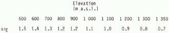
Table I shows the difference in mean summer temperature between the east (Setesdal) and the west (Suldal) during the Atlantic period compared to the present for elevations above 500 m. We see that the difference in mean summer temperature between Setesdal and Suldal was greater during the Atlantic period than at present.
Concluding Remarks
Our study indicates that the decrease of the mean summer temperature from the Atlantic period to the present time was less at the coast than in the inner valley districts of south-west Norway. This implies that the horizontal temperature difference between east and west was greater during the Atlantic period than it is at present. We also suggest that the decrease of summer temperature from the Atlantic period to the present was less in the upper mountain areas than in the lower valley floors to the east.
The mean summer temperatures suggested for the Atlantic period, and their gradients to the west and east of the watershed, must be in accordance with a certain mean general circulation, typical for the Atlantic period. The circulation seems to have had fundamental similarities with that of the present, a conclusion which arises from the result that the mean summer temperatures during the Atlantic period were higher to the east of the watershed than to the west. This points to more clouds and precipitation, and less sunshine on the west side than on the east side during the Atlantic period, which suggests mean westerly winds like those at present.
The steeper topographic temperature gradient on the east side compared to the west side during the Atlantic period may indicate more pronounced subsidence of the air on the lee side of the mountains to the east than at present. This can be explained by more frequent anticyclonic circulation over south-west Norway during the Atlantic period arising from more frequent movement of the Azoric High towards the north-east.
From time to time, this situation has been altered by the movement of migratory cyclones from west to east along the north-western flank of the high mountain ridge, transporting air from the Atlantic Ocean across the coastal mountains of south-west Norway. These air masses were warmer and moister than at present, and resulted in the liberation of greater amounts of heat during the Atlantic period than today to the leeward side of the mountains. This is in accordance with Reference FæsgriFægri (1940), who stated that the Atlantic period was characterized by more windy conditions than the Sub-Boreal period.
Extrapolation of the mean summer temperature curve of the Atlantic period on the east side to sea-level, leads to very high mean summer temperature differences between the Atlantic period and the present in the lowlands. The calculation indicates that the suggested topographic temperature gradient on the east side is too great. More realistic temperature curves for both sides may be obtained by thorough research on the distributions of thermophile plant species dating from the Atlantic period in the lowland areas.
Numerical experiments, such as those carried out by Manabe and Wetherald (Reference Manabe and Wetherald1975, Reference Manabe and Wetherald1980), may give a firmer basis for understanding the general circulation in different geographical areas during periods with higher temperatures. Such models must be in accordance with observed evidence of past warmer climates in different parts of the world. We hope that our study may form a contribution to such models.
K Blystad and P Blystad participated in the field work. Our colleagues at the Archaeological Museum in Stavanger, the Botanical Institute in Bergen and the Norwegian Meteorological Institute have contributed with fruitful discussions and technical help. The manuscript was read and commented upon by P Blystad, R Mook and A Simonsen, All 14C dates were carried out by R Nydal and S Gulliksen at the Trondheim Radiological Dating Laboratory. Financial support was given by the Archaeological Museum in Stavanger, the Norwegian Research Council for Science and Humanities (NAVF) and Borregaard A S Research Council. To all these persons and institutions we proffer our sincere thanks.


