


Introduction
The West Antarctic ice sheet (WAIS) is vitally controlled by processes at its base (Reference Kamb, Alley and BindschadlerKamb, 2001). The fast-moving ice streams within the WAIS are moving at speeds 10–100 times greater than the surrounding ice sheet, with the exception of Kamb Ice Stream that slowed about 150 years ago but had been very active before that, judging from the buried crevasses (Reference Retzlaff and BentleyRetzlaff and Bentley, 1993). These ice-stream speeds are much faster than those that can be explained by internal deformation of the ice alone. Additional mechanisms have been invoked to account for this remarkable dynamics. Before basal sliding processes become active, the bed must be at the melting point (Reference Engelhardt and KambEngelhardt and Kamb, 1998). Therefore, thermal conditions under and in the ice are of primary importance for ice streaming to occur. Temperature measurements not only reflect present conditions at the bed, but also contain the thermal history within the ice that in many cases is far from a steady-state temperature distribution (Reference Jenssen and RadokJenssen and Radok, 1961; Reference Radok, Jenssen and BuddRadok and others, 1970, Reference EngelhardtEngelhardt, 2004).
Temperature Measurements
The present paper summarizes the results of all temperature– depth profile measurements in 22 out of 119 boreholes drilled through the ice with the hot-water drilling technique during the field seasons 1988–2001. The boreholes were located on Whillans Ice Stream (WIS), Kamb Ice Stream (KIS; former Ice Stream C), and Bindschadler Ice Stream (BIS; former Ice Stream D), on Engelhardt Ridge (ER; former ice ridge BC), on Raymond Ridge (RR; former ice ridge CD), on the Unicorn (UC) between Van der Veen Ice Stream (VIS; former Ice Stream B1) and Alley Ice Stream (AIS; former Ice Stream B2), on a former shear margin within the Unicorn, called the Fishhook, and in the Dragon, the southern shear margin of AIS with the Unicorn (Fig. 1). Because the boreholes occur in clusters at the drilling sites, they are not individually resolved in the figure.
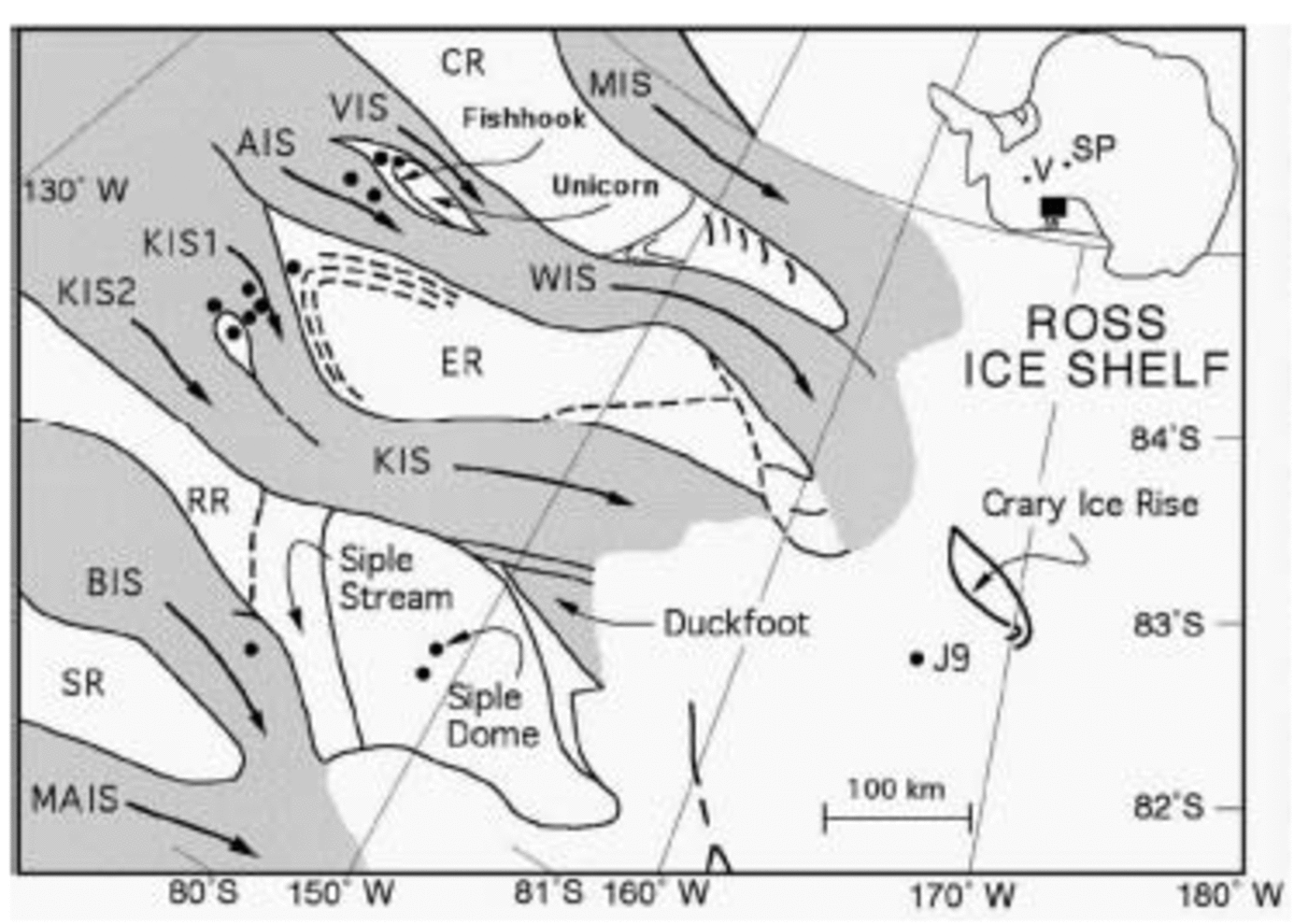
Fig. 1. Study area of the WAIS. Drill sites are indicated as black dots that in most cases represent more than one borehole. The locations of all the boreholes are listed in Table 1. South Pole (SP) and the position of a volcano (V) are also indicated. The new names of ice streams and interstream ridges are abbreviated: MIS, Mercer Ice Stream; WIS, Whillans Ice Stream; VIS, Van der Veen Ice Stream; AIS, Alley Ice Stream; KIS, Kamb Ice Stream; BIS, Bindschadler Ice Stream; MAIS, MacAyeal Ice Stream; CR, Conway Ice Ridge; ER, Engelhardt Ice Ridge; RR, Raymond Ice Ridge; SR, Shabtaie Ice Ridge.
The temperature sensors were thermistors, which were carefully calibrated for the expected temperature range to ±0.02˚C. They were protected from pressure in small metal cases with electrical feed-through. They were emplaced vertically 100m apart in the freshly drilled and therefore water-filled boreholes. In the lowest and highest 100–200m of the borehole the spacing of the thermistors was 20 m. The thermistors froze in within < 1 day in the upper half of the borehole, but required more time in the warmer, lower part of the borehole, and up to several weeks 20m above the bed. The temperatures were measured daily and again 1–4 years later, when the borehole sites were revisited to collect the data loggers. From selected borehole sites we had Argos satellite data transmission. In general, temperature profiles accurate to 0.05 K required equilibration periods of about 1 year. Details of the procedure are given in Engel-hardt and Kamb (1993).
Observations
The whole study area is low in elevation, 300–600ma.s.l. The ice is relatively thin, 900–1200 m, and has a very low surface slope of 0.001. The surface temperatures are between –25 and –27˚C (Table 1). Since bed temperatures are at or near the pressure-melting point, the differences between top and bottom temperatures lie between 21.7 and 25.8˚C. All fast-moving ice streams are wet at the base. The basal temperatures are sometimes a few tenths of a degree below the pressure-melting point for a pure ice/water interface, due to the impurity content of the ice and of the water at the ice/till interface (Reference Wettlaufer, Wettlaufer, Dash and UntersteinerWettlaufer, 1999a). Kamb Ice Stream, a special case that stopped rapid motion about 150 years ago (Reference Whillans, Bentley, van der Veen, Alley and BindschadlerWhillans and others, 2001), still has a melted bed except for a sticky spot around boreholes KIS 00-1,2 (Table 1) and KIS 00-3, another borehole drilled in the same area, which revealed a frozen bed from the drilling record and borehole images. Interstream ridges, like RR between KIS and BIS, and the Unicorn between VIS and AIS, are frozen to the bed.
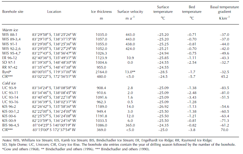
Table 1. Temperatures measured in boreholes
Basal Temperature Gradients
Despite similar depths and surface temperatures of the boreholes within our study area, there is one very obvious difference. The basal temperature gradients (Table 1) were determined from a linear fit through the measurements in the lowest 100 m. They fall into two distinct groups, those with a temperature gradient higher than, and those with a gradient lower than, 50 K km–1. The ice in the basal zone with the higher or stronger temperature gradients is colder than the ice in the lower or weaker temperature gradient group, which is warmer relative to the other group. Therefore, we call one group the cold-ice group (Fig. 2), the other the warm-ice group (Fig. 3). The Siple Dome profile, a typical temperature profile falling into the warm group, is included in Figure 2 for comparison. In Table 1, the temperature profiles in the Byrd and Crary Ice Rise boreholes are also cited for comparison.
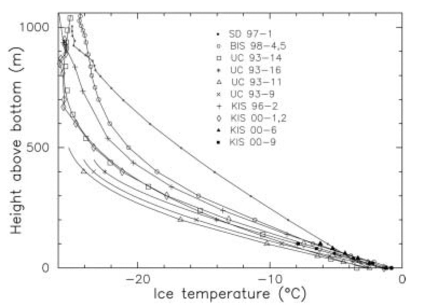
Fig. 2. Temperature–depth profiles of sites significantly colder than the Siple Dome temperature profile in borehole SD 97-1. High basal temperature gradients.

Fig. 3. Temperature–depth profiles of Whillans Ice Stream, Siple Dome, and Byrd (Reference Gow, Ueda and GarfieldGow and others, 1968). Low basal temperature gradients.
Siple Dome (SD) is the best example of ice that has been frozen to the bed for at least 100 kyr (Reference Nereson, Waddington, Raymond and JacobsonNereson and others, 1996), but, because of the temperature changes that occurred 10 kyr ago after the last glacial period, its temperature profile has not reached full steady state (Reference EngelhardtEngelhardt, 2004). Because of its unique location at a stable dome site, the SD temperature profile had more time to approach steady state than all the other measurement sites that experienced continuous changes in boundary conditions due to flow. The temperatures in boreholes of WIS and of ER are not too much different from the SD profile. The Byrd borehole basal temperature gradient is also similar to the SD case.
All other boreholes on KIS and BIS and on the Unicorn (UC), a stagnant island between VIS and AIS, with basal temperature gradients sometimes much higher than 50 K km–1, seem to be far from steady state. One borehole, UC 93-14, also called the Fishhook borehole, was drilled at a location of the old, now inactive shear margin, the Fishhook within the UC. The ER borehole, ER 96-12, is also relatively close to or on an old shear margin with KIS.
Steady state is approached if boundary conditions are kept stable for a long time. Given the boundary conditions, surface temperature, accumulation rate, bed temperature, and using the material properties of ice, its thermal conductivity, one can calculate theoretical steady-state temperature profiles (Reference Radok, Jenssen and BuddRadok and others, 1970). If we compare the measured temperature profiles that have similar boundary conditions with the theoretical profiles, one should see that those with warmer ice temperatures are closer to steady state than the ones with colder temperatures relative to the others. For example, compare the SD temperature profile with the UC profiles, which are located not far apart on the WAIS. Surface and bed temperatures are very close, both are frozen to the bed, accumulation rate should be similar, and thickness is comparable: 1000m at SD and 900–1100m at the UC. One would expect similar temperatures, especially similar basal temperature gradients; but no, the temperature profiles are distinctly different. One could produce steeper temperature profiles by drastically changing the boundary conditions, for instance by increasing the accumulation rate by a factor of two or reducing the surface temperature by 10˚C. This is unrealistic and would be rejected as questionable. So there is what might be called a dilemma, a paradox, a discrepancy. One possible explanation of this phenomenon is presented here as a working hypothesis, admittedly still speculative because of the complex nature of the events.
The Unicorn Paradox
The Unicorn temperature profiles reveal a high basal temperature gradient indicating relatively cold ice near the bed. But, just a few kilometers across the Dragon shear margin to the north on AIS, the temperature gradient is much lower and the ice is distinctly warmer. These observational facts reproduced in many boreholes on both sides of the Dragon are a paradox that requires a satisfactory explanation.
High basal temperature gradients can arise from two effects: first, from basal melting caused by high geothermal flux, and secondly, from substantial longitudinal extensional flow.
The UC is frozen to the bed, which excludes a local geothermal flux that is high enough for melting the ice at the bed. The UC ice velocities are very low, with no extensional flow to produce changes in the temperature profile. Since the boundary conditions of the UC and SD are similar, we would expect that the temperature profiles of the UC should be similar to that of SD. However, they are markedly different. Therefore, UC ice cannot have formed locally, it must have come from somewhere else.
The nearest candidate for supplying ice to the UC would be WIS and its tributaries AIS and VIS. But although WIS has a wide catchment area and an overdeepened interior and is also flowing fast, extensional flow did not produce any appreciable cooling of the basal ice. Instead, the measured profiles show much warmer ice than those in the UC, which is consistent with the modeling of the temperature evolution (Fig. 4; Reference Lingle, Brown, Van der Veen and OerlemansLingle and Brown, 1987; Reference Engelhardt and KambEngelhardt and Kamb, 1993). The basal temperature gradient changes from 24.3 K km–1 at the ice divide to 49.1 K km–1 at the grounding line. Therefore it is almost impossible to have the UC ice with a gradient of 83.5 K km–1 originate from the WIS system unless very implausible assumptions are made about the recent evolution of its basal conditions. WIS could not possibly have delivered cold ice only several hundred years ago and have been heated up since then to achieve the present temperature profile. Since UC ice could not have formed locally and could not have been supplied by WIS, we have to find yet another source. In the following we will try to test the hypothesis that the UC ice comes from KIS, the next nearest source.

Fig. 4. Temperature profiles along flowline from ice divide to grounding line every 10 km. Each of the 67 profiles is offset by one degree with respect to the previous one. The first profile at the ice divide (left) shows the actual temperatures.
At first it seems far-fetched to assume that cold ice had to cross WIS to be delivered to the UC where at some point it was left stranded and began to freeze to the bed.
Both the temperature profiles of the UC and KIS are strikingly similar, so that there is no problem in making the thermal connection. However, to overcome the barrier of WIS or AIS, the critical assumption has to be made that KIS had to be in a state of extremely vigorous flow, in a state of surge of such magnitude that we call it a super-surge. A dramatic event of this type may be necessary to explain the UC paradox. Surges of course are well known. They can be initiated in a fairly short period of time. In Alaska, USA, surges start within weeks or months, with speed-ups over a limited time by a factor of up to 100, and they terminate in hours or days, as was the case with Variegated Glacier (Reference KambKamb and others, 1985). The super-surge must have had enough force to overwhelm and push away slower-moving WIS and deposit colder ice at the UC. In surge situations, one can often observe highly convoluted medial moraines and cut-off or displacement of non-surging tributaries. After the super-surge stopped, normal flow of WIS resumed, fed from a catchment area like the one used today. The stranded, cold UC ice started freezing to the bed. This relatively young basal ice at the UC is still far from a steady state as compared to SD. It will require thousands of years to approach equilibrium.
Surges are episodes of vigorous flow that are far out of balance. They can last only a limited time because they exhaust their source area to a point where flow is no longer sustainable. Most surges are triggered by internal instabilities or critical thresholds where basal temperatures, water storage and water pressure play a crucial role to create a slippery bed. Since the WAIS is in a rift zone, elevated geothermal flux can be expected, which in fact has been measured at Siple Dome to be 69 mWm–2 (Reference EngelhardtEngelhardt, 2004), and which is shown on a heat-flow map of Antarctica created by Reference Ritzwoller, Shapiro, Levshin and LeahyRitzwoller and others (2001) using the global heat-flow database and guided by a 3-D velocity model of the crust and upper mantle. The average geothermal flux of West Antarctica is 100 mWm–2, three times higher than that of East Antarctica. Geothermal flux in rift zones can be quite variable, even much higher than that at SD. In places where the ice is deep enough, melting will eventually occur. The 2164m deep Byrd borehole is melted at the bed. However, the Byrd borehole has a basal temperature gradient similar to that of SD, suggesting a geothermal flux similar to that of SD. The basal ice is warm in contrast to KIS.
After being vigorously active for a limited time, KIS stopped almost completely in the lower part to a speed of presently 0–20ma–1, while in the upper reaches it is still moving at a modest speed of 60 ma–1 (Fig. 5; Reference Conway, Catania, Raymond, Scambos, Engelhardt and GadesConway and others, 2002). During the surge the surface of KIS was heavily crevassed, which was observed by radar sounding in numerous transects. In one case we realized we were drilling into a large crevasse buried about 30 m deep below surface, because we could freely lower the drill an additional 30 m into a void. After the surge stoppage, layers of undisturbed firn buried the crevasses. From the total thickness of the undisturbed layers and the accumulation rate, the time of stoppage about 150 years ago was obtained (Reference Retzlaff and BentleyRetzlaff and Bentley, 1993). Several areas of deeper buried crevasses and shear margins near SD have also been recognized (Reference Jacobel, Scambos, Nereson and RaymondJacobel and others, 2000; Reference NeresonNereson, 2000). The most prominent one is situated north of RR, named the ‘Siple Ice Stream’. The buried features point to an event that peaked and then declined about 500 years ago. This is evidence that 500 years ago the WAIS system was considerably more active than it is now.
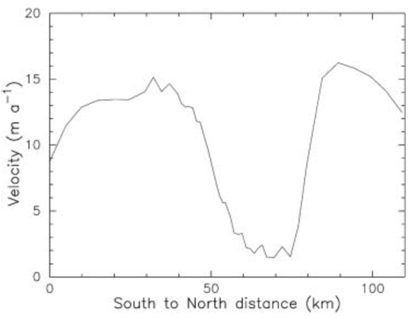
Fig. 5. Velocity profile across Kamb Ice Stream, including the sticky spot.
As shown for WIS (Fig. 4), longitudinal extension does not contribute enough to produce a steep basal temperature gradient as found in KIS. In fact, internal strain heating may even counterbalance the extensional effect. Jacobshavn Isbræ, Greenland, for example shows a 400m thick layer of temperate basal ice (Reference Iken, Echelmeyer, Harrison and FunkIken and others, 1993). But during a very active surge phase, cooling from very high extensional flow may play a role. Another way to achieve a steep basal temperature gradient as in KIS is substantial basal melting. This could occur in the deepest part of KIS where one arm flows out of the Bentley Trench. Extensive modeling of KIS shows the relative contributions of basal melting and extensional flow (Reference Vogel, Tulaczyk and JoughinVogel and others, 2003). Another possibility that cannot be ruled out completely is the existence of an active subglacial volcano that was reported by Reference Blankenship, Bell, Hodge, Brozena, Behrendt and FinnBlankenship and others (1993) using aero-geophysical data. This volcano, if confirmed by additional surface measurements and borehole drilling, would be located at the right spot in the upper catchment area of KIS at 81.8767˚ S, 111.3017˚W (Fig. 1). Reference Tulaczyk, Kamb, Scherer and EngelhardtTulaczyk and others (1998) discovered about 3% volcanic material in till samples of the ice streams, a small but not negligible amount. This would be consistent with a relatively recent eruption, so that erosion of volcanic rock and mixing into the till has not yet significantly altered the till composition. If this volcano existed and erupted more than 500 years ago, it could have caused substantial basal melting, which in turn could have triggered the super-surge that peaked about 500 years ago, leaving behind a number of features that are still vividly displayed by the temperature profiles, the buried crevasses and shear margins, and distorted flowlines on the Ross Ice Shelf.
The amount of melting that would be needed to arrive at present KIS temperature profiles can be estimated by starting with a WIS-type temperature profile. Full transition from WIS to KIS temperatures within the last 500 years, from melting alone, would require the removal of about 200 m of basal ice. This demonstrates the severity of the difference between the two types of temperature profiles. In any case, a great amount of water is necessary to keep the ice streams lubricated, especially the cold ones. Without additional water supplied from upstream sources, KIS and BIS would eventually freeze into their beds and stop moving completely. KIS has already done so in part. Cooling from extensional flow alone is not sufficient. It must be a combination of both melting and extensional flow.
In favor of the volcano hypothesis is the creation of a huge meltwater reservoir with no pre-existing drainage system. A surge normally starts from an area that becomes critically unstable when the ice is uncoupled from the bed by high water pressure. Once started, a surge bulge propagates mostly downslope at relatively high speeds, activating the ice in its path. It also can activate additional upstream areas. Under surge conditions, water flows under the ice in a sheet, because water channels are unstable and are destroyed. Behind the surge front, basal water at high pressure is retained, providing efficient lubrication for the surge. When the surge front reaches the terminus, in our case the grounding line, an outburst flood will terminate or slow down the surge considerably.
The UC paradox and many features in the Siple Coast ice-stream system can be explained under such a scenario (Reference Scambos, Nereson and FahnestockScambos and others, 1998; Reference Fahnestock, Scambos, Bindschadler and KvaranFahnestock and others, 2000; Reference Jacobel, Scambos, Nereson and RaymondJacobel and others, 2000). With a typical ice stream length of about 600 km and a typical surge speed of 10–100 m d–1, and the surge front passing at a speed of the same order of magnitude, normally higher, the super-surge episode would have lasted somewhere between 16 and 160 years. A super-surge would also have delivered a huge amount of additional ice to the Ross Ice Shelf, which would translate into increased calving at the ice-shelf front. The curves of relative sea-level rise over the last 2000 years show conspicuous spikes 600–400 years ago even during the Little Ice Age (Reference Nydick, Bidwell, Thomas and VarecampNydick and others, 1995).
The super-surge obliterated the normally smooth flow-lines between the ice streams’ grounding line and the ice-shelf front. By comparison, the flowlines on the Ronne Ice Shelf are well preserved, not altered by interference of a drastic event. The surface features on the Ross Ice Shelf are a jumble of ice rafts, irregular crevasse patterns, old flowlines at an angle to present flow directions, and highly distorted flowlines (Reference Casassa and TurnerCasassa and Turner, 1991), and kinks in surface slope (Reference GrayGray and others, 2002).
Kamb Ice Stream
KIS was probably the most active player under the super-surge scenario. Its position in the middle of the surge fan down-glacier from the source region of meltwater provided ample lubrication. An outburst flood at the grounding line, a common feature of fast glacier surges, must have drained enough water for the ice stream to become less lubricated. It settled down and essentially came to a halt. KIS contains cold ice with a high basal temperature gradient of –60 to –70 K km–1. There is still enough water at the bed of the ice stream, so that freeze-on of ice, sometimes mixed with till, continues. Drainage now occurs in a more channeled fashion. One of our boreholes, KIS 00-9, entered into a water-filled cavity that was 1.4m deep. The water pressure in this channel is almost 1 bar below the ice overburden pressure. Therefore, the drainage through these channels must be well developed, unlike in fast-moving ice streams where basal water pressure is much closer to the flotation level and drainage must be in a thin sheet (Reference Engelhardt and KambEngelhardt and Kamb, 1997). Judging from the lowest frozen-on debris-free ice layer, there must be a channel at least 200 m long where the ice did not touch the till bed. Presently, freeze-on is 7 mm a–1, which we calculated from the basal temperature gradient of –60 K km–1, the heat conductivity of ice and the geothermal flux of 69 mWm–2 measured at nearby SD. The total freeze-on after the initial volcanic melt event is 10m, of which 7m is clear ice with very little debris content. The topmost layer with debris is located about 1m below the bubbly-ice to clear-ice transition. The lowest 5 m is a complex sequence of debris-laden layers alternating with clear ice layers. At the present freeze-on rate of 7 mm a–1, the total freeze-on of basal ice would require 1450 years. The initial freeze-on rate after the melting phase must have been much higher because of the initially higher temperature gradient. The time since freeze-on started is probably much less than 1450 years. Other ways of debris entrainment and other freeze-on processes such as diffusion of water along grain boundaries may have contributed at various times (Reference WettlauferWettlaufer, 1999b). Basal water flow under depressurizing conditions along a hydraulic gradient will form frazil ice that can accrete at the base because of the Clausius–Clapeyron effect.
In the middle of KIS is a bedrock hump about 100m higher in elevation than the surrounding ice-stream bed. This hump was overrun by the super-surge because it has the same temperature profile as KIS, but it was also a place where freeze-on occurred first, creating a sticky spot. The cold ice got stranded there, while the still active ice had to flow around it, forming the present flow stripes. The sticky spot is a drop-shaped feature 15km across and 30 km long. It could be seen as an analog to the UC. Figure 5 shows the velocity profile across KIS, including the sticky spot. Although the basal temperature there is only –1.38˚C, the bed is solidly frozen. In three boreholes drilled through the KIS sticky spot, a connection with a basal water system could not be established. One borehole, KIS 00-10, in the transition zone between the sticky spot and KIS, exhibited a delayed connection to the basal hydraulic system, showing that the ice is barely frozen or starting to freeze to the bed. A similar weak connection was also found in borehole ER 9612 at the southern margin of KIS.
All the other boreholes drilled on KIS made instant connection to the basal hydraulic system, allowing water to flow out of the borehole, as indicated by a water-level drop in the borehole from 30 m to about 100m below the surface. The best connection was made in borehole KIS 00-9, which intersected a subglacial channel with water flowing at a speed of several centimeters per second.
Therefore, KIS outside the sticky spot is presently not frozen to its bed. However, freeze-on of basal ice and debris is still going on because there is enough water available in the till and resupplied by still active channels from reservoirs upstream. Overall, this ongoing freeze-on process has reduced basal lubrication and increased basal friction. Other features, like the Duckfoot, were active during the super-surge as well. Stranded shear margins are still visible as topographic surface features and as disturbed subsurface layering detected by radar (Reference Jacobel, Scambos, Nereson and RaymondJacobel and others, 2000). The slow-down of KIS is a consequence of water loss, basal freeze-on and formation of sticky spots.
Whillans Ice Stream
A branch of the super-surge has very likely invaded the WIS area. This fast-moving ice must have spilled over and temporarily replaced the normal flow of ice from the WIS catchment area. The cold ice also overran the Unicorn area except for a small island below the Fishhook, which is still visible as a prominent feature within the UC (Reference Clarke, Liu, Lord and BentleyClarke and others, 2000). As the surge subsided, a mass of relatively cold ice was left stranded on the UC, now a frozen bed island between VIS and AIS. Subsequently, the ice flowing from the WIS catchment area returned to its previous flow regime, pushing the cold ice downstream. Therefore, the temperatures in this part of WIS are again warmer and no longer affected by super-surge generated ice, and the freeze-on rate is practically zero. If this interpretation is correct, then a large body of colder ice still exists in the lower reaches of WIS and on the Ross Ice Shelf. The presence of cold ice in the downstream WIS area can also explain ongoing changes, especially a slow-down in this area (Reference Bindschadler and VornbergerBindschadler and Vornberger, 1998), and it may contribute to a stick–slip velocity pattern observed by Reference Bindschadler, Vornberger, King and PadmanBindschadler and others (2003). A part of Crary Ice Rise was also formed from a raft of cold ice freezing at the bottom about 450 years ago (Reference Bindschadler, Roberts and IkenBindschadler and others, 1990). Additional features can be found at the WIS shear margins that are related to the super-surge and its aftermath (Reference Whillans, Bentley, van der Veen, Alley and BindschadlerWhillans and others, 2001). From the temperature profile at borehole J9 downstream of WIS on the Ross Ice Shelf, Reference MacAyeal and ThomasMacAyeal and Thomas (1979) not only discovered a basal temperature gradient much higher than presently on WIS, but also a basal freeze-on rate of 8 mm a–1, again pointing inescapably to a major event in the history of the flow of WIS.
Siple Dome and Raymond Ridge
The summit of Raymond Ridge, Siple Dome was not affected by the super-surge. The temperature profiles are still responding to the last glacial–interglacial temperature changes at the surface 10 000 years ago. The basal temperature, now at –2.54˚C, will reach the melting point in about 6000 years. The basal temperature gradient of –32.7 K km–1 reflects the local geothermal flux of 69 mWm–2 (Reference EngelhardtEngelhardt, 2004).
Large areas of present RR, now dormant and probably frozen to the bed, were active during the super-surge period. A prominent scarp to the north delineates the former margin of a whole ice-stream branch, called Siple Ice Stream. The dating of its stagnation also provides a constraint for the super-surge about 500 years ago (Reference Jacobel, Scambos, Nereson and RaymondJacobel and others, 2000).
Bindschadler Ice Stream
The temperature–depth profile of BIS is almost identical with that of KIS. It belongs to the cold group of basal ice temperatures (Fig. 2). The basal temperature gradient is high at –61.2 K km–1. The base is at the pressure-melting point at –0.82˚C. A basal debris-laden ice layer about 10m thick was encountered on drilling through the basal ice. Figure 6 shows the drilling-hose tension in KIS and BIS, as it varies when the drill is hydraulically mining through the basal debris-laden ice layer, until the drill hits the subglacial till. From borehole video in KIS we know thickness and composition of the debris-laden basal ice. The similarity of the drilling-hose tension plots in both boreholes near the bed suggests that we have similar basal ice layers at both borehole sites. The bed is reached when the water level in the borehole drops from the bottom of the permeable firn layer at 30 m, to a depth of 100m below the surface, and simultaneously the tension of the hose increases abruptly. The water-level drop is an indication of the presence of a basal water system. All of the BIS boreholes, which were located no more than 30 m apart, connected instantly to the basal hydraulic system. The water level dropped to identical depths, indicating a well-developed basal hydraulic system. Abundant basal water is still available at the borehole drill sites. We find that cold ice is still flowing down BIS, and at the same time freeze-on continues at a rate of 7 mm a–1. These observations fit again into a super-surge scenario in which a great mass of cold ice is swept down the ice-stream path. Because of this cold ice near the base and ongoing freeze-on processes, BIS is very complex in detail, with a number of sticky spots, complicated crevasse patterns, with relict shear margins, more diffuse and much wider than those along WIS, and with a kink in the velocity profile near the ice-streaming onset (Reference Bindschadler, Vornberger, Blankenship, Scambos and JacobelBind-schadler and others, 1996 Reference Bindschadler, Chen and Vornberger, 2000). The Byrd borehole within the catchment area of BIS shows a basal temperature profile comparable to WIS and that of Siple Dome. If normal flow continues, warmer basal ice could eventually replace the cold ice in the same way as is happening on WIS. Since the thermal characteristics of BIS are the same as those of KIS, it is possible that the lower reaches of BIS could shut down by continued freeze-on and loss of water lubrication the same way as KIS did 150 years ago. However, since the amount of water still available or produced in upstream reservoirs is not known, it is hard to predict if and when such a shut-down would actually occur.
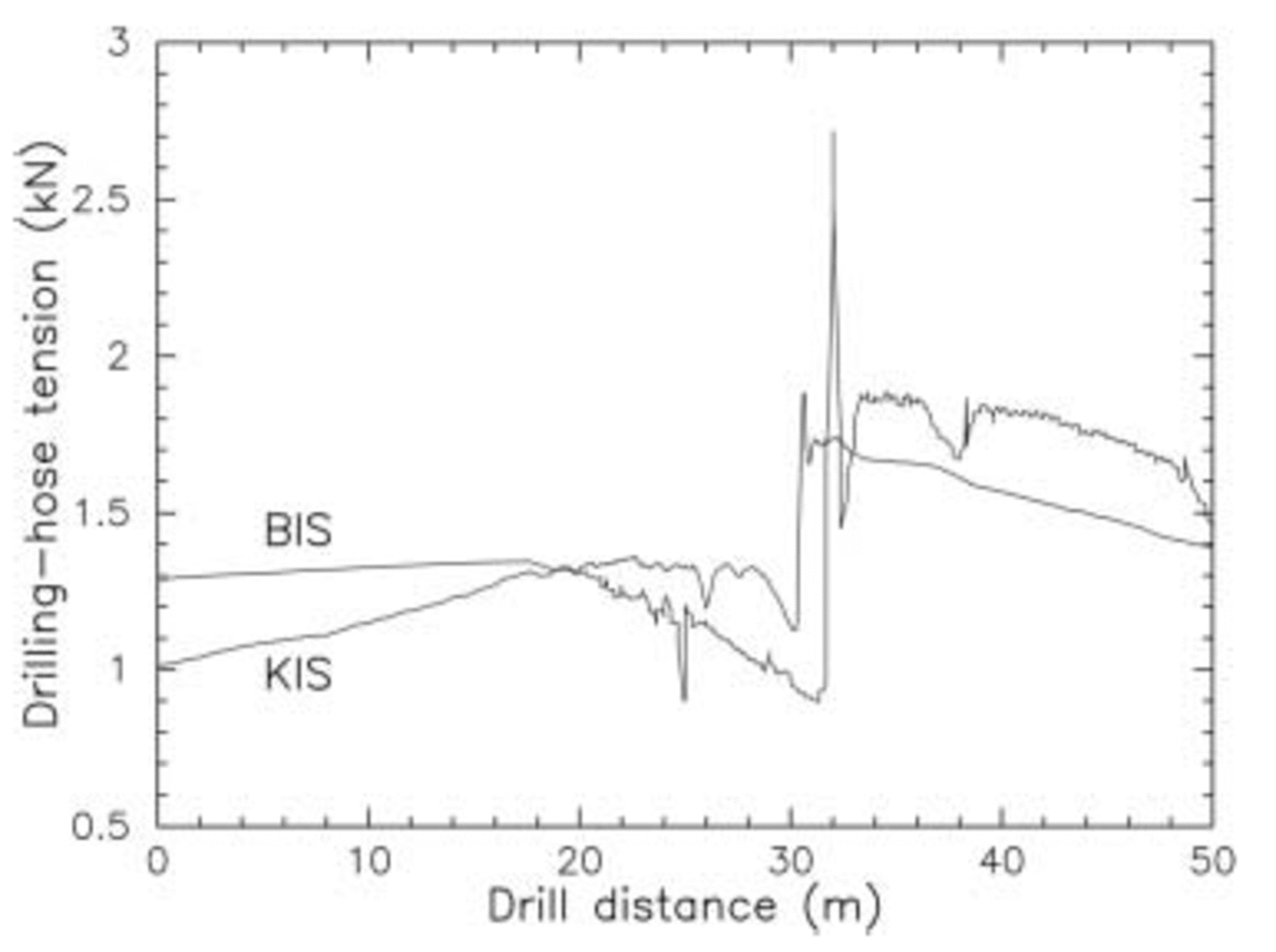
Fig. 6. Drilling-hose tension indicating a basal debris-laden ice layer under Kamb and Bindschadler Ice Streams. The sharp peaks are caused by water-level drop in the boreholes when the drill reaches the bed and the borehole connects to a basal hydraulic system.
Conclusions
The Unicorn paradox shows, side-by-side, high basal temperature gradients at the UC and much lower temperature gradients only a few kilometers away at Whillans Ice Stream. This poses a real challenge to the interpretation of the evolution of the thermal regime of the WAIS. To explain this unusual situation, a major event, like a super-surge, could have happened, which was able to move Kamb Ice Stream ice to the UC across the barrier of the normal course of Whillans Ice Stream. If such a super-surge is the solution to the Unicorn paradox, it then offers also an explanation for many observed features in the Siple Coast ice-stream system. The super-surge activated substantial areas that became stagnant after the surge peaked and subsided about 500 years ago. ‘Siple Ice Stream’ with a distinct shear margin scarp on the northern flank of Siple Dome is the most prominent example. These stagnant areas are still visible as subtle topographic features at the surface or as buried crevasses detected by radar.
Acknowledgements
Since the fieldwork for this study was completed, the ice streams have been renamed, starting with Whillans Ice Stream in honor of the late I. Whillans who commenced work on Ice Stream B and continued to discover and explain an endless number of features of this peculiar ice stream he was relentlessly dedicated to decipher. Foremost, I thank B. Kamb for his inspiration and constant support. I am very grateful for the good work and the cheerful enthusiasm of our field assistants who helped us in 11 field seasons in Antarctica: N. Humphrey, R. Scherrer, M. Fahnestock, M. Wumkes, J. Chadwick, J. Berkey, H. Aschmann, M. Blume, H. Conway, T. Svitek, J. Zachariasen, D. McKee, L. Allison, T. Melbourne, D. Semmens, M. Sahani, P. Svitek, K. Petersen, P. White, S. Web, M. Jackson, B. Waddington, K. Quinn, K. Svenson, S. Schmidt, E. Miya, K. Echelmeyer, D. Baldwin, S. Wheeler, R. Lohman, B. Pratt, M. Bergman, M. Eaton, J. Hashimoto, C. Weber, E. Hinds, P. Cutler, G. Catania, S. Das, E. Mueller, A. Bucki, S. Colley, A. Blanchard, D. Reusch, H. Schwaiger, B. Farrow, S. Gordon, M. Bachmann, R. Bolsey, G. Gerbi, D. Abrams, S. Vogel, A. Behar, R. Sterr, K. Batten, M. Koppes. The US National Science Foundation Office of Polar Programs funded this work under grant OPP-9615420. In addition, many people of the Antarctic support and logistics groups were essential for this work. I thank two anonymous reviewers for many inspiring suggestions and my editor R. Mulvaney for gentle guidance.


