


Introduction
The lakeshore settlements (Pfahlbausiedlungen) of the Alpine foreland offer a unique insight into the Neolithic way of life in this region. Excellent preservation of organic remains enables high-resolution dating of settlements through dendrochronology, and the wealth of organic artefacts and ecofacts permits a detailed understanding of subsistence practices. In this study, we explore the social and ecological implications of nitrogen isotopic determinations of charred crop remains, considering two contrasting situations on Lake Constance, south-west Germany: i) the ‘isoscape’ of an entire cereal harvest from a single year (3910 BC) at Hornstaad-Hörnle IA; and ii) long-term continuity and change in crop-growing conditions over 1000 years at Sipplingen (c. 4000–2800 cal BC; Figure 1). The crop nitrogen isotope values are interpreted within the rich context of multi-stranded archaeological evidence recorded at these sites. Together, they enable new understandings of the social geography and ecology of early farming landscapes across a synchronous horizon at Hornstaad, and through a millennium of social and environmental change at Sipplingen.

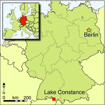
Figure 1. Map showing location of Hornstaad-Hörnle IA and Sipplingen in south-west Germany.
The nature of early farming on Lake Constance
Although much is known about plant use at Neolithic lakeshore sites through the analysis of both carbonised and waterlogged macrobotanical remains (summarised in Jacomet &Brombacher Reference Jacomet and Brombacher2005), less is known about the nature of farming itself—i.e. labour inputs, levels of manuring, longevity of cultivation and the interplay between crop and animal husbandry. Analysis of weed seeds often found associated with crop remains can reveal much about agricultural productivity, the degree of soil disturbance—relating to weeding and hoeing—and the permanence of plots (e.g. Bogaard Reference Bogaard2004), but in order to relate weeds to a particular crop species, they must be found in pure crop samples. Few perennial or woodland species have been found in association with crop remains from lakeshore sites, indicating that cultivation was permanent on long-lived plots (e.g. Brombacher & Jacomet Reference Brombacher, Jacomet, Schibler, Hüster-Plogmann, Jacomet, Brombacher, Gross-Klee and Rast-Eicher1997; Maier & Vogt Reference Maier and Vogt2001: 84). Moreover, the weeds indicate a spectrum of relatively productive conditions (e.g. Bogaard Reference Bogaard2004: 113), while variation in their prevalence and diversity between stores could indicate differences in weeding regimes between plots (e.g. Maier & Vogt Reference Maier and Vogt2001: 94).
Reconstructing past farming practices through crop nitrogen isotope values
Crop nitrogen isotope (δ15N) values integrate a range of environmental and physiological processes, but largely reflect the δ15N value of the soil in which they are grown (e.g. Högberg Reference Högberg1997). Potential causes of high plant δ15N are: recent forest clearance by burning, which volatilises ammonium (Ehrmann et al. Reference Ehrmann, Biester, Bogenrieder and Rösch2014); loss of nitrogen through bacterially mediated denitrification, which occurs in seasonally waterlogged, anaerobic soils (Finlay & Kendall Reference Finlay, Kendall, Michener and Lajtha2008); and high levels of organic nitrogen relative to plant demand, leading to high microbial turnover and subsequent loss of nitrogen as ammonia and ammonium (Aguilera et al. Reference Aguilera, Araus, Voltas, Rodríguez-Ariza, Molina, Rovira, Buxó and Ferrio2008). All of these processes lead to preferential loss of 14N, leaving 15N-enriched nitrogen in the soil for plants to take up.
A major influence on crop δ15N values in agricultural systems is manuring. Studies of modern crops have found that manuring can increase cereal δ15N values by as much as 10‰, according to the intensity—amount and frequency (e.g. Fraser et al. Reference Fraser, Bogaard, Heaton, Charles, Jones, Christensen, Halstead, Merbach, Poulton, Sparkes and Styring2011). Based on these modern studies, cereal grain δ15N values for high (35+ tonnes/ha), medium (10–15 tonnes/ha) and low/no (<10 tonnes/ha) levels of manuring have been estimated (see Figure 5; cf. Bogaard et al. Reference Bogaard, Fraser, Heaton, Wallace, Vaiglova, Charles, Jones, Evershed, Styring, Andersen, Arbogast, Bartosiewicz, Gardeisen, Kanstrup, Maier, Marinova, Ninov, Schäfer and Stephan2013: fig. 1). Further, as changes in manuring levels take a number of years to register in crop δ15N values (Fraser et al. Reference Fraser, Bogaard, Heaton, Charles, Jones, Christensen, Halstead, Merbach, Poulton, Sparkes and Styring2011), any distinctions must reflect sustained differences in cultivation, indicating long-lived plots and land investment over many years.
Intensive manuring requires a high input of labour, and, in modern farming studies, is usually associated with small-scale, ‘garden’ cultivation (Halstead Reference Halstead1987). This usually goes hand-in-hand with other labour-intensive cultivation practices such as weeding and hoeing, thereby creating conditions that favour weed species able to thrive in disturbed soils. Crop nitrogen isotope analysis can, therefore, demonstrate whether the productive conditions indicated by weed seeds are also associated with manuring. As a finite resource, manure must be applied strategically to maximise yields and enable surpluses to buffer against potential future crop failures (Halstead Reference Halstead1989). Crop nitrogen isotope values can reflect these decisions for individual archaeological contexts, distinguishing household preferences, as well as identifying the more general intensity with which farming was practised, and whether this changed with fluctuations in climate, environment and cultural developments.
Hornstaad-Hörnle IA
Hornstaad-Hörnle IA is a Neolithic (3918–3902 cal BC) pile settlement (with houses raised on stilts) located on the shore of Lake Constance in south-west Germany (Figure 1). The first houses were built in 3918 cal BC, and the village grew haphazardly, with no visible structural organisation or hierarchy (Billamboz Reference Billamboz, Dieckmann, Harwath, Hoffstadt and Billamboz2006; Figure 2). In 3910 cal BC, a fire destroyed almost the entire village, preserving the remains of the houses and the crop harvest from this year in a single layer. The lake eroded away much of this burnt cultural deposit, but an area of c. 2500m2, encompassing 21 houses, remained available for further investigation (centre of Figure 2). Systematic sampling over 211m2 of this burnt layer at 1m intervals (Figure 3) has revealed numerous crop stores containing thousands of exceptionally well-preserved carbonised cereal ears and loose grains. The high number of cereals and low number of wild plants place the fire in late summer/early autumn, shortly after the harvest but before wild foods such as hazelnuts and wild apples were ripe (Maier Reference Maier1999). This burnt layer thus provides a high-resolution snapshot of village life shortly after the harvest, and an insight into crop cultivation practices carried out by different households (Maier Reference Maier1999).

Figure 2. Plan of Hornstaad-Hörnle IA, showing the construction dates of houses built before the fire in 3910 cal BC (drawing by Arno Harwath, modified by Amy Styring); numbers 1–15 on the plan refer to the houses that have been identified in the burnt layer.

Figure 3. Plan of Hornstaad-Hörnle IA, showing location of the cereal grain samples selected for δ15N analysis; the numbers indicate houses referred to in the text (drawing by Arno Harwath, modified by Amy Styring).
The harvest was dominated by tetraploid naked wheat (Triticum durum/turgidum type), followed by barley (Hordeum vulgare ssp. nudum), einkorn (T. monococcum) and emmer (T. dicoccum; Maier & Vogt Reference Maier and Vogt2001: 33). Each store contained almost pure deposits of a single cereal species; mixing of cereals within samples is attributed to the collapse of buildings and scattering of stores during the fire (Maier & Vogt Reference Maier and Vogt2001: 38). Based on the quantity of cereal grains recovered from the sampled deposits, it has been estimated that 10–18ha of arable land would have been required to produce the cereal harvest for 40 houses. This could have been on the well-drained soils between 300–700m from the settlement (Maier Reference Maier1999). The lack of perennial weed seeds, and particularly woodland species in the cereal stores, indicates that cultivation was continuous and not carried out on recently cleared plots (Maier Reference Maier1999). Variation in the prevalence and diversity of weeds between stores implies differences in growing conditions between plots, but post-depositional mixing of cereal species within stores precludes comparison of growing conditions associated with different species or households (Maier & Vogt Reference Maier and Vogt2001: 38).
Each house had its own ‘toolkit’ (Dieckmann et al. Reference Dieckmann, Maier, Vogt, Lippert, Schulz, Shennan and Teschler-Nicola2001), including wooden ‘hand-ards’, polished stone axes, flint points and fishing equipment, indicating that households were autonomous units, at least with regard to subsistence activities (cf. Ebersbach Reference Ebersbach, Menotti and O’Sullivan2012). There seems, however, to be a pairing of houses in which certain plants, such as cornelian cherry (Cornus mas)—which at the time only grew on the southern slopes of the Alps—and objects associated with certain activities, such as bead production or fishing, were concentrated (Hoffstadt & Maier Reference Hoffstadt and Maier1999). The diversity in plant use and processing activities between individual and groups of households reflects findings from other lakeshore sites (Jacomet & Brombacher Reference Jacomet and Brombacher2005), illustrating varying degrees of inter-household cooperation as well as independence.
While these lines of evidence reveal much about the social geography of Hornstaad, isotopic analysis of the crop remains themselves has the potential to provide a direct and independent means of investigating cultivation practices and relationships between households. In particular, crop isotope analysis can address the question of whether households were autonomous at all levels of production, as implied by their individual toolkits, or whether they farmed communally, pooling the harvest before redistribution. This in turn has wider social implications, as communal farming implies some form of central management to coordinate the workforce. Communal farming could also be concomitant with more extensive farming practices—i.e. less intensive weeding/manuring on a larger scale to meet the village's needs, rather than smaller plots, intensively managed by individual households (Bogaard Reference Bogaard2004: 54). Given the inherent disparity in the productivity of fixed plots of land (Halstead Reference Halstead1989), if farming was not communal, social mechanisms with varying degrees of formality must have been in place to redistribute surpluses in order to maintain what seems to have been a relatively egalitarian society (cf. Halstead Reference Halstead1989; Honegger Reference Honegger2005).
Crop-growing conditions at Hornstaad-Hörnle IA
Details of the analytical methods used may be found in the online supplementary material. There is a large variation in cereal grain δ15N values (2–11‰; Table S1),but the standard deviation is quite low (1‰; Figure 4). The positive skew in the distribution of cereal δ15N values is due to the very low proportion of cereal grains with δ15N values <4‰. As plant δ15N values vary across locations, the best estimates of unmanaged plant δ15N values derive from local herbivore bone collagen δ15N values, which are used to gauge the δ15N value of the plants on which they fed (for the method see the online supplementary material; cf. Bogaard et al. Reference Bogaard, Fraser, Heaton, Wallace, Vaiglova, Charles, Jones, Evershed, Styring, Andersen, Arbogast, Bartosiewicz, Gardeisen, Kanstrup, Maier, Marinova, Ninov, Schäfer and Stephan2013). The cereal grain δ15N values (mean = 5.0‰) at Hornstaad are consistently higher than the estimated unmanaged baseline δ15N value (Figure 5), indicating that cereals were growing in soil significantly more enriched in 15N than that of the natural environment.

Figure 4. Histogram of cereal grain δ15N values from Hornstaad-Hörnle IA; the red line plots the normal distribution.

Figure 5. Boxplot of δ15N values of carbonised naked wheat, einkorn and barley grain samples from Hornstaad-Hörnle IA; the dashed blue line is the mean estimated herbivore plant diet (mean herbivore collagen δ15N–4‰); grey shading is 1 standard deviation; manuring levels are defined from modern, long-term experimental farming plots (cf. Bogaard et al. Reference Bogaard, Fraser, Heaton, Wallace, Vaiglova, Charles, Jones, Evershed, Styring, Andersen, Arbogast, Bartosiewicz, Gardeisen, Kanstrup, Maier, Marinova, Ninov, Schäfer and Stephan2013).
At Hornstaad, it is not probable that the high cereal grain δ15N values were caused by recent forest clearance and burning, as the archaeobotanical weed assemblages contain few woodland species and are consistent with continuous cultivation (Maier Reference Maier1999). It is also unfeasible that denitrification was the cause because weeds indicative of wet growing conditions were not found in the cereal stores (Maier & Vogt Reference Maier and Vogt2001: 94), and detailed soil survey has identified well-drained soils, providing ample land for arable crops within 700m of the village (Maier Reference Maier1999). It is therefore most probable that the relatively high cereal grain δ15N values are due to high organic soil nitrogen content—whether as a result of natural soil fertility or from the addition of organic nitrogen in manure. Cereal grain δ15N values exceeding 4‰ have not been observed in modern, long-term experimental and traditional farming studies across Europe without the addition of manure (Fraser et al. Reference Fraser, Bogaard, Heaton, Charles, Jones, Christensen, Halstead, Merbach, Poulton, Sparkes and Styring2011; Kanstrup et al. Reference Kanstrup, Thomsen, Andersen, Bogaard and Christensen2011). This strongly suggests that the cereals grown at Hornstaad were receiving manure but, given the variable range of δ15N values, in different quantities. This suggestion agrees with the relatively high and varied δ15N values of cereal grains recorded from previous analysis of the same layer (Bogaard et al. Reference Bogaard, Fraser, Heaton, Wallace, Vaiglova, Charles, Jones, Evershed, Styring, Andersen, Arbogast, Bartosiewicz, Gardeisen, Kanstrup, Maier, Marinova, Ninov, Schäfer and Stephan2013). Moreover, manuring could account for the positive skew in the δ15N distribution (Figure 4), if few cereal plots were receiving low levels/no manure. Naked wheat and barley have slightly lower δ15N values than einkorn (p <0.01), but there is no significant difference between the δ15N of naked wheat and barley at a village-wide level (Figure 5).
Social geography of farming at Hornstaad-Hörnle IA
As the cereal grains recovered at Hornstaad derive from a single harvest, their δ15N values provide a unique opportunity to assess potential variation in crop-growing conditions andagricultural decision-making among households, thereby illustrating the social dimension of crop-husbandry practices. Spatial analysis of the cereal grain δ15N values using the Getis-Ord Gi* statistic (Getis & Ord Reference Getis and Ord1992) shows clustering of similar values in certain households (Figure 6a–c; see online supplementary material). Such clustering eliminates the possibility that the harvest was pooled among all households prior to storage and thus provides independent support for the autonomy of these households at the level of production and subsistence (cf. Hoffstadt & Maier Reference Hoffstadt and Maier1999).

Figure 6. Spatial clustering of δ15N values of: a) naked wheat; b) einkorn; and c) barley grain samples from Hornstaad-Hörnle IA (drawing by Arno Harwath, modified by Amy Styring).
There is a clustering of high δ15N values of naked wheat in houses 9 and 11d, contrasting with a cluster of low values in house 3 (Figure 6a). These clusters are confined to the houses in which they were found, despite the potential scattering of cereal grains when buildings collapsed during the fire. There is also clustering of einkorn δ15N values, but locations of high/low einkorn δ15N values do not overlap with those of naked wheat (Figure 6b). The einkorn from area 11b/1 (between houses 11b and 1) and area 8/9 has relatively high δ15N values, whereas the einkorn values from area 11c/11a are relatively low. If the significantly different δ15N values of wheat in these houses are due to variable levels of manuring, this indicates long-term differences between areas harvested by different houses. The discrete clusters of naked wheat δ15N values in houses 8 and 9 indicates that they were cultivating wheat in different plots, under different cultivation conditions. This is interesting because the finds of cornelian cherries in these two neighbouring houses had suggested that they were paired (Hoffstadt & Maier Reference Hoffstadt and Maier1999).
In contrast to the wheats, there is little clustering of barley δ15N values (Figure 6c). The range in barley δ15N values across the site is 5.3‰, larger than that determined for cereal grains receiving the same amount of manure and growing within a single modern field (Fraser et al. Reference Fraser, Bogaard, Charles, Styring, Wallace, Jones, Ditchfield and Heaton2013). This implies that barley at Hornstaad was growing in a range of conditions, potentially relating to manuring intensity, but that individual households were not manuring their barley variably enough to yield discrete clusters of different δ15N values. This could indicate that households were opportunistically growing their barley on small patches of land, leading to high variability in barley δ15N values within households. It is possible that barley was grown communally under different manuring conditions and then pooled prior to distribution, but this is not probable as this was not the case with the wheats. These contrasts between wheat and barley δ15N value distributions correspond with different culinary uses: wheat was recovered in the remains of porridge and bread, while barley grains were probably roasted (Maier Reference Maier1999; Maier & Vogt Reference Maier and Vogt2001: 59). Crop δ15N analysis on a household scale thus reveals differences in cultivation conditions between wheat and barley that are not evident when considered for the village as a whole.
Sipplingen
Sipplingen is situated on the northern shore of Lake Constance (Figure 1), about 14km north-east of Hornstaad-Hörnle IA. Here, steep hills, up to 560m in height, enclose a hilly area of approximately 200ha around the lake, itself 400m asl (Jacomet Reference Jacomet1990). Baum (Reference Baum2014) modelled the area of arable land required to support 750 people—a generous estimate of the settlement's population at its peak. Assuming intensive cultivation was practised (cf. Bogaard Reference Bogaard2004: 113), this area was estimated to be 120ha, which could be accommodated within the boundary of hills, whereas if crops were grown under a shifting cultivation regime, 2250ha of land would have been required (Baum Reference Baum2014).
Sipplingen has a stratigraphic sequence of 15 cultural layers, dating from c. 4000–c. 2800 cal BC, providing a detailed record of settlement in the area spanning the Hornstaad (3919–3902 cal BC), Pfyn (3870–3500 cal BC) and Horgen (c. 3300–2800 cal BC) cultures. Comprehensive dendroarchaeological, archaeobotanical and zooarchaeological investigations have revealed much about the changing nature of the settlement and its subsistence strategies over time. Isotopic analysis of the carbonised crop remains from the site provide a means of investigating how crop nitrogen isotope values changed throughout the settlement's occupation in response to changes in climate, environment and cultural influences.
The initial occupation of the lakeside bay in 3919–3904 cal BC (phase SiA) comprised two contemporary settlements. Houses were constructed with wood from primary forest, although some evidence for coppicing indicates that the area was probably populated and the forest exploited for wood before the site's occupation (cf. Billamboz Reference Billamboz, Honegger and Mordant2012; Lechterbeck et al. Reference Lechterbeck, Edinborough, Kerig, Fyfe, Roberts and Shennan2014). Crop remains and wild plant resources from the forest were recovered in equal abundance from this layer, with einkorn being the most ubiquitous crop (Billamboz et al. Reference Billamboz, Baum, Kaiser, Maier, Matuschik, Müller, Stephan, Steppan, Schlichtherle and Vogt2013). The succeeding phase dates to the early Pfyn culture (SiB; 3857–3817 cal BC) and saw expansion from a hub of a few houses to its maximum extent in 3840 cal BC, followed by a reduction in size around 3825 cal BC (Billamboz Reference Billamboz, Honegger and Mordant2012). Houses were constructed from wood of varying ages, suggesting that clearance operations were small in scale rather than communal, and that different households exploited different areas of the forest (cf. Billamboz & Köninger Reference Billamboz, Köninger, Dörfler and Müller2008).
Wild plant remains and animal bones (aurochs and red deer) decreased in abundance in the next phase of settlement, suggesting a diminished reliance on wild resources (SiC; 3795–3786 cal BC). The increasing economic importance of cultivated crops (mainly naked wheat and flax) and domestic cattle continued between 3727 and 3680 cal BC (SiD), when there was also an increase in the size of the settlement and in levels of construction activity, using wood from increasingly degraded forest. Figure 7 shows the excellent state of preservation of a naked wheat ear from this layer. Within less than 80 years, there was a dramatic reversal in the economic importance of domestic crops and fauna, with the frequency of red deer bones surpassing those of cattle, and the concentration of cereals in the botanical assemblage dropping considerably (SiE; Steppan & Stephan Reference Steppan, Stephan, Schlütter, Greiff and Prange2012; Billamboz et al. Reference Billamboz, Baum, Kaiser, Maier, Matuschik, Müller, Stephan, Steppan, Schlichtherle and Vogt2013). This coincided with a reduction in settlement size, followed by a hiatus in settlement occupation for 300 years, from 3600–3300 cal BC (Billamboz Reference Billamboz, Honegger and Mordant2012). Similarly dramatic economic changes occurred at Swiss lakeshore sites at the time, and have been attributed to climatic deterioration and a rise in lake levels (Schibler et al. Reference Schibler, Jacomet, Hüster-Plogmann and Brombacher1997). At Sipplingen, severe degradation of the forest due to felling may have led to a shortage of wild resources, which also contributed to the site's abandonment. This cycle of establishment, expansion and then reduction (and in some cases abandonment) is common across lakeshore sites around Lake Constance (Billamboz & Köninger Reference Billamboz, Köninger, Dörfler and Müller2008), but, in this instance, it seems to have been hastened by climatic decline.

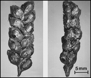
Figure 7. Photograph of both sides of a naked wheat ear (T. durum/turgidum) recovered from layer SiD at Sipplingen (photograph by Amy Styring); the line represents 10mm.
During the settlement hiatus, reforestation occurred (Lechterbeck et al. Reference Lechterbeck, Edinborough, Kerig, Fyfe, Roberts and Shennan2014), and reoccupation of the site at the beginning of the Horgen culture in 3316 cal BC (SiG) used wood from established trees for house construction (Billamboz Reference Billamboz, Honegger and Mordant2012). For the next 300 years, from 3300–3000 cal BC, there was another cycle of initial clearance followed by increasing exploitation and degradation of the forest. Emmer (T. dicoccum) was now the most economically important cereal while cultivation of opium poppies (P. somniferum) increased. Pig bones became more numerous, which could reflect more intensive forest management, and cattle numbers increased, probably due to their use as draft animals from c. 3150 cal BC (SiJ/K; cf. Hüster-Plogmann & Schibler Reference Hüster-Plogmann, Schibler, Schibler, Hüster-Plogmann, Jacomet, Brombacher, Gross-Klee and Rast-Eicher1997). It is also during this phase that a new harvesting method was introduced: sickles were replaced by harvesting knives, which are believed to have been more efficient and allowed a larger cereal harvest (Billamboz et al. Reference Billamboz, Baum, Kaiser, Maier, Matuschik, Müller, Stephan, Steppan, Schlichtherle and Vogt2013).
Both the settlement layout and use of the forest changed dramatically in the later Horgen period (SiN; 2925–2855 cal BC). Large houses were arranged along a single entry road, and a palisade surrounded the houses on the landward side of the settlement, echoing the layout of other settlements at this time (Billamboz Reference Billamboz, Honegger and Mordant2012). Houses were constructed using trees of a similar age, implying a more rigid and coordinated management of the forest. Weed seeds and pollen analysis suggest that the landscape was now more open, with little dense woodland and extensive pasture and fallow fields (Jacomet Reference Jacomet1990; Lechterbeck et al. Reference Lechterbeck, Edinborough, Kerig, Fyfe, Roberts and Shennan2014). During 2876–2855 cal BC (SiNb2), all plants decreased in frequency, and, while pigs also decreased in number, the remains of red deer became more common, suggesting an increased reliance on hunting. This period marks the end of the Horgen culture.
Change in crop-growing conditions over 1000 years at Sipplingen
Details of the analytical methods used can be found in the online supplementary material. The δ15N values of cereal grains from Sipplingen range from 3–7.2‰ (Table S2), with a mean of 5‰. As observed at Hornstaad-Hörnle IA, the cereal grain δ15N values are consistently higher than the δ15N value estimated for unmanaged plants on the site (estimated from the mean herbivore bone collagen δ15N value of 5.5‰, as determined by Steppan and Stephan Reference Steppan, Stephan, Schlütter, Greiff and Prange2012; Figure 8), indicating that cereals at Sipplingen were also growing in soil significantly more enriched in 15N than that of the natural environment. These δ15N values are consistent with a medium–high level of manuring.

Figure 8. Crop δ15N values during the occupation of Sipplingen, from c. 4000–2800 cal BC; the dashed blue line is the mean estimated herbivore plant diet (mean herbivore collagen δ15N–4‰); the grey shading is 1 standard deviation; manuring levels are defined from modern, long-term experimental farming plots (cf. Bogaard et al. Reference Bogaard, Fraser, Heaton, Wallace, Vaiglova, Charles, Jones, Evershed, Styring, Andersen, Arbogast, Bartosiewicz, Gardeisen, Kanstrup, Maier, Marinova, Ninov, Schäfer and Stephan2013).
Throughout the settlement's occupation, naked wheat δ15N values are significantly higher than barley δ15N (t(29) = 2.534, p = 0.017; Figure 8). This indicates a deliberate and sustained difference in the cultivation of these two cereals, suggesting that they occupied different ecological and, potentially, social niches throughout the Late Neolithic. Such a finding also agrees with the conclusions of Riehl (Reference Riehl2004), who, based on archaeobotanical analysis of crop remains from phase SiD, suggests that economic differences could explain why naked and glume wheats were stored in their ears, whereas barley was threshed before storage. This difference is less pronounced in the post-hiatus occupation, however, with barley δ15N values staying relatively constant, while naked wheat δ15N values significantly decrease (t(25) = −2.185, p = 0.038).
It is striking that naked wheat and barley δ15N values do not change significantly throughout the Pfyn culture. This is despite the dendroarchaeological, palynological and archaeobotanical evidence for increased clearance of the forest (Billamboz Reference Billamboz, Honegger and Mordant2012; Lechterbeck et al. Reference Lechterbeck, Edinborough, Kerig, Fyfe, Roberts and Shennan2014), presumably leading to an expansion of arable cultivation and a greater pressure on manure supply. Most noteworthy is that naked wheat and barley δ15N values do not change in the years immediately leading up to the settlement hiatus, when the decreased abundance of crops and increase in wild animal bones on the site has been interpreted as evidence of successive crop failures leading to an increased reliance on wild resources (Schibler et al. Reference Schibler, Jacomet, Hüster-Plogmann and Brombacher1997). The recalcitrance of soil organic nitrogen could go some way to explaining the lack of change in crop δ15N values, as the δ15N value of bread wheat grown on previously manured plots at the long-term experimental site of Rothamsted, UK, took 70 years to decrease below 3‰ with no manure, having previously had a δ15N value of 6‰ (Fraser et al. Reference Fraser, Bogaard, Heaton, Charles, Jones, Christensen, Halstead, Merbach, Poulton, Sparkes and Styring2011). Manuring levels must, however, have been maintained throughout most of the Pfyn culture, and given that crop δ15N values did not fall below 3‰, it appears that the majority of manure nitrogen had not been exhausted. This supports the hypothesis that the abandonment of the settlement was as a result of climatic deterioration, rather than degradation of the soil (cf. Schibler et al. Reference Schibler, Jacomet, Hüster-Plogmann and Brombacher1997).
Following the 300-year gap in settlement occupation, emmer replaced naked wheat as the most ubiquitous cereal species. This coincides with a decrease in naked wheat δ15N values, suggesting that as it was no longer the most economically important cereal crop, it was not being manured as intensively, although this interpretation remains tentative due to the low number of samples. This inference is supported by the fact that the δ15N values of glume wheat samples (emmer and einkorn), albeit scarce, are higher than those of naked wheat for the first time. Again, it is pertinent that the crop δ15N values are generally consistent with medium–high levels of manuring, indicating that manure was still a valued and widely exploited resource. It is believed that agriculture became more extensive in the Horgen period, as larger areas of forest were cleared and cattle were used as draft animals. Nevertheless, the crop δ15N values indicate that manuring levels were maintained, possibly due to greater availability with the growing importance of cattle. The crop δ15N results demonstrate that, although the adoption of draft animals suggests a shift towards more extensive farming regimes by reducing the human labour required to prepare a given area, there was no radical shift to a fundamentally different farming system, with lower inputs per unit area (cf. Isaakidou Reference Isaakidou, Hadjikoumis, Robinson and Viner-Daniels2011).
The very high δ15N value of a sample of peas (Pisum sativum) from the latest phase of the site further alludes to an abundance of organic-rich waste around the settlement itself, which is also implied by an abundance of weed seeds characteristic of eutrophication (Billamboz et al. Reference Billamboz, Baum, Kaiser, Maier, Matuschik, Müller, Stephan, Steppan, Schlichtherle and Vogt2013). The δ15N value of 4.7‰ is very high for pulses, as in the absence of manure they generally have δ15N values close to that of atmospheric N (0‰; Yoneyama et al. Reference Yoneyama, Fujita, Yoshida, Matsumoto, Kambayashi and Yazaki1986), and experimental plots of peas and broad beans receiving up to 30 tonnes/ha manure also show no increase in their δ15N values (Fraser et al. Reference Fraser, Bogaard, Heaton, Charles, Jones, Christensen, Halstead, Merbach, Poulton, Sparkes and Styring2011). In fact, the only pulses with such high δ15N values in modern situations were grown on small garden plots manured so intensively that they formed artificial ‘dung-soil’ (Fraser et al. Reference Fraser, Bogaard, Heaton, Charles, Jones, Christensen, Halstead, Merbach, Poulton, Sparkes and Styring2011). Given that the ubiquity of pulses is very low on the site (Billamboz et al. Reference Billamboz, Baum, Kaiser, Maier, Matuschik, Müller, Stephan, Steppan, Schlichtherle and Vogt2013), this could indicate that they were grown in small garden plots close to people's houses, where they could receive high levels of manure or household waste.
In the final phase of the settlement for which we have crop remains (SiNb2; 2876–2855 cal BC), it is curious that despite dramatic changes in both the settlement layout and use of the forest (Billamboz Reference Billamboz, Honegger and Mordant2012), there is no corresponding change in the crop δ15N values that can be detected in the available samples. This implies that manuring levels were maintained, as management of the forest and layout of the settlement became more regulated.
Conclusions
Nitrogen isotope analysis of crop remains has shown how arable land management varied both within a community and throughout time, enriching our knowledge of farming practices beyond that of general depictions. For the first time, cultivation choices, probably regarding manure use, have been shown to take place at a household level at Hornstaad-Hörnle IA, highlighting the differential availability of this important resource and demonstrating the potential of crop nitrogen isotope studies for further understanding social geography in the Neolithic. Moreover, as organic-N turnover is relatively slow, differences in crop δ15N reflect long-lived management decisions and social dynamics, probably surpassing the lifetime of the houses themselves (Billamboz Reference Billamboz, Dieckmann, Harwath, Hoffstadt and Billamboz2006). The consistent difference in δ15N of naked wheat and barley prevailed at Sipplingen for over 1000 years, indicating that these crops occupied different ecological and social niches in the Late Neolithic. A decrease in the abundance and δ15N values of naked wheat at Sipplingen during the Horgen cultural phase reflects its changing status, as it was replaced by emmer as the dominant cereal. The overall continuity in crop δ15N values over time at Sipplingen reflects sustained investment in the land, maintaining levels of manuring despite pressure from wider economic drivers, such as the expansion of agricultural land and changes in land management strategies, and notwithstanding a hiatus in settlement occupation. New technological developments, such as the adoption of cattle as draft animals, were incorporated into a well-established intensive agricultural system that persisted for over 1000 years.
Acknowledgements
The work reported here was funded by the European Research Council (AGRICURB project, grant 312785, PI Bogaard). We would also like to thank Arno Harwath for help with the preparation of the Hornstaad-Hörnle IA plans; Bodo Dieckmann, Jutta Hoffstadt, Oliver Nelle and Richard Vogt for useful discussion of the results. We would also like to thank Irenäus Matuschik for helpful comments on the manuscript.
Supplementary material
To view supplementary material for this article, please visit http://dx.doi.org/10.15184/aqy.2015.192


 Open access