


Introduction
The ice-free areas of northern Victoria Land, Antarctica, are underlain by continuous permafrost (Fig. 1) (e.g. Reference Lozej, Tabacco, Meneghel, Orombelli, Smiraglia and LonginelliLozej and others, 1991; Reference Guglielmin, Biasini and SmiragliaGuglielmin and others, 1997; Reference GragnaniGragnani and others, 1998; Reference French and GuglielminFrench and Guglielmin, 2000a). However, our understanding of the amount, type and distribution of ice contained within these perennially frozen earth materials is limited. The same is generally true of the other ice-free areas of Antarctica. This contrasts with our knowledge of ground ice in the permafrost regions of the Northern Hemisphere (e.g. Reference Lorrain and DemeurMackay, 1972, Reference Mackay1983; Reference MackayMackay and others, 1979; Reference Mackay and DallimoreMackay and Dallimore, 1992; Reference Astakhov, Kaplyanskaya and TarnogradskiyAstakhov and others, 1996). The aim of this paper is to document the different surface and subsurface ice bodies that are present in the Northern Foothills (74˚45' S, 164˚ W) region of northern Victoria Land (Fig. 2).
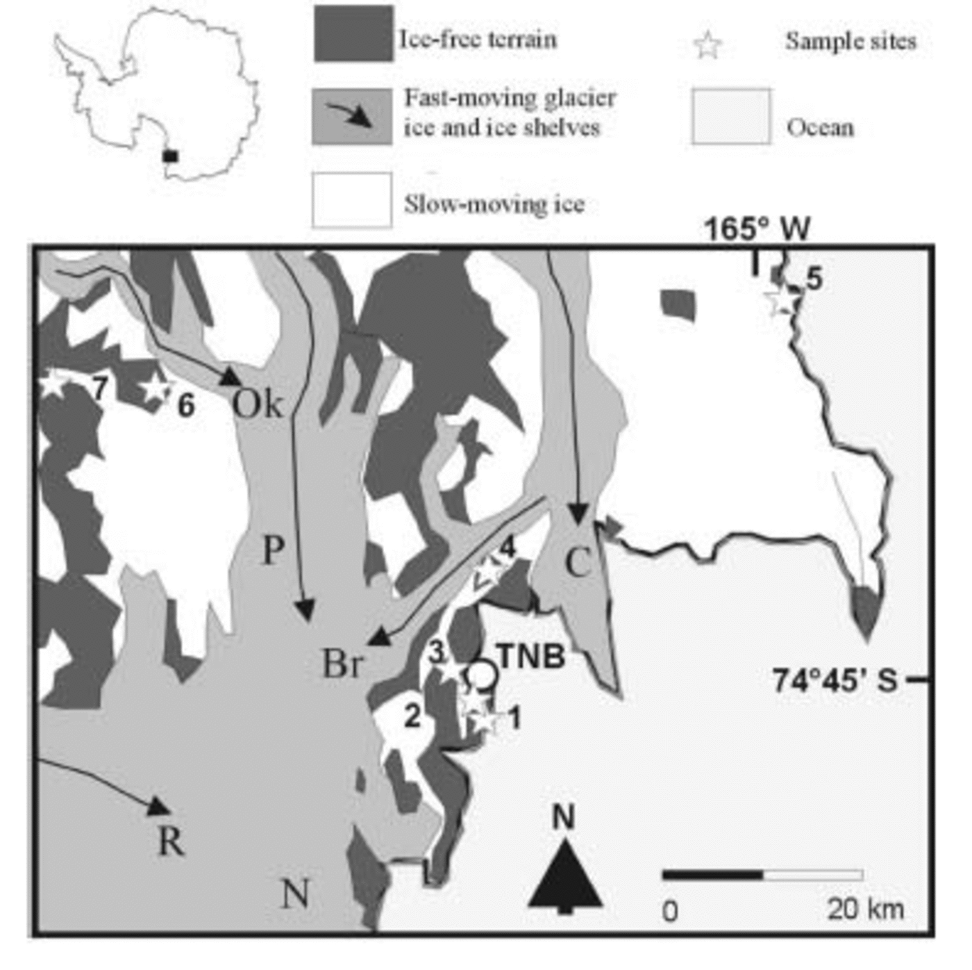
Fig. 1. Location map of the Northern Foothills showing location of the PNRA Terra Nova Bay (TNB) station and sampling sites mentioned in the text. Sample site locations: 1. Boulder Clay Glacier; 2. Amorphous Glacier; 3. Enigma Lake; 4. Mount Browning; 5. Edmonson Point; 6. Simpson Crags; 7. Mount Baxter. The arrow shows the direction of main ice movement. R, Reeves Glacier; P, Priestly Glacier; Br, Browning Glacier; N, Nansen Ice Shelf; Ok, O’Kane Glacier; C, Campbell Glacier Tongue.
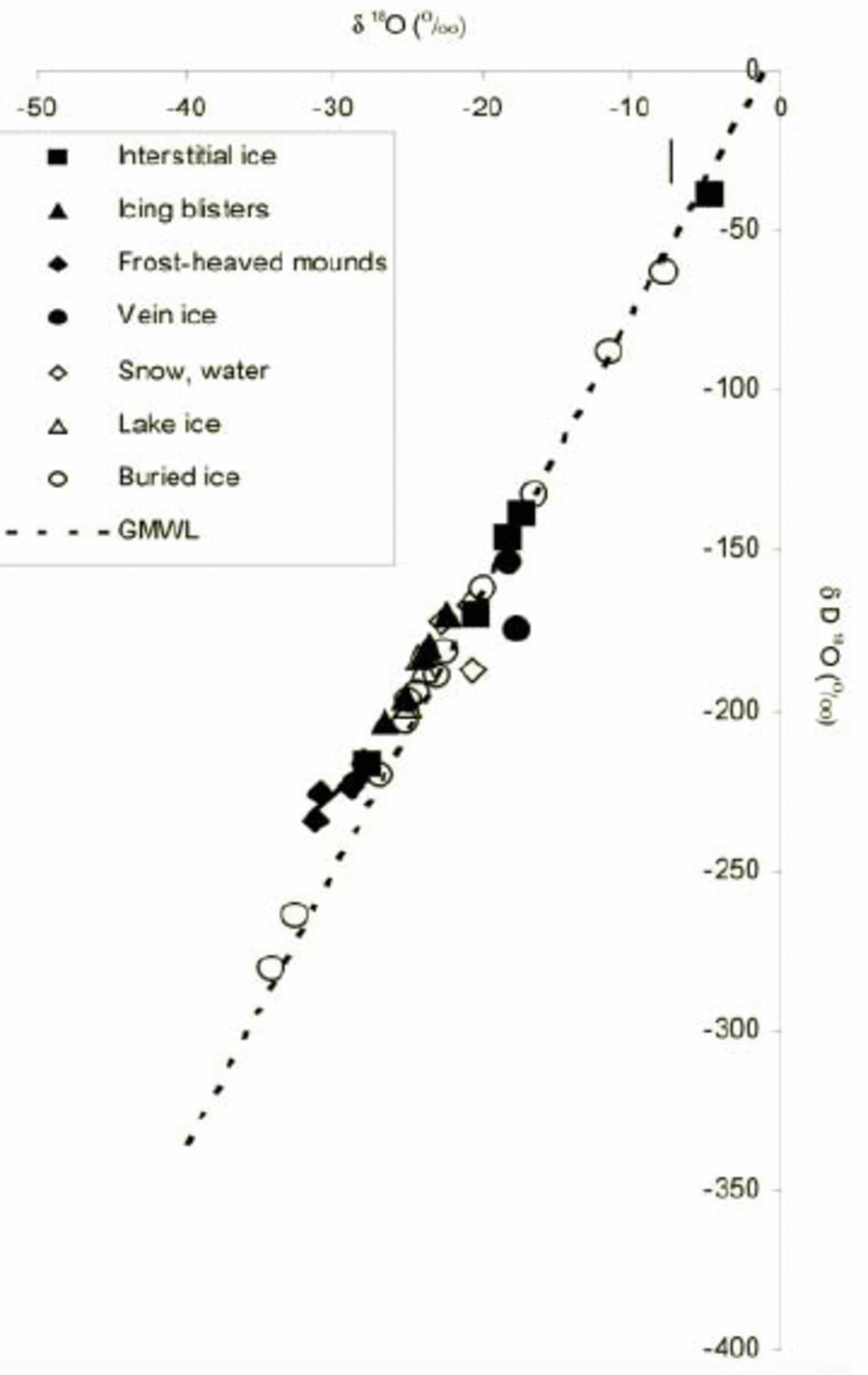
Fig. 2. Plot of δ18O and deuterium (δD) isotope values obtained from ice samples in the Northern Foothills region. The GMWL (Reference CraigCraig, 1961) is shown. Data compiled from Reference Lozej, Tabacco, Meneghel, Orombelli, Smiraglia and LonginelliLozej and others (1991), Reference CaprioliCaprioli and others (1987), Reference GragnaniGragnani and others (1998), Reference French and GuglielminFrench and Guglielmin (2000a, Reference French and Guglielminb) and Guglielmin (unpublished data). The lineal fit to the data points representing frost-heaved mounds is Δd = 4.3596δ18O – 95.614, with a correlation coefficient R 2 = 0.842.
Permafrost and Terrain Conditions
The Northern Foothills are located between the Tertiary volcanic complex of Mount Melbourne (2732ma.s.l.) to the north and Drygalski Glacier to the south. The region is mainly an ice-covered landscape. Ice-free areas are few. Most are underlain by Ordovician- and Precambrian-age granites and meta-sediments (Granite Harbour Formation and Wilson Terrane Complex; Reference CarmignaniCarmignani and others, 1988). Unconsolidated Quaternary-age sediments are limited to the lower elevations of the Northern Foothills, Tarn Flat and Inexpressible Island and consist mainly of ablation till overlying dead-ice topography interpreted as either pre-Late-Wisconsin (e.g. on Mount Browning), Late-Wisconsin (e.g. on Boulder Clay) or Holocene in age (e.g. on Simpson Crags) (Reference BaroniBaroni, 1987; Reference Baroni and OrombelliBaroni and Orombelli, 1987, 1988; Reference Orombelli, Baroni and DentonOrombelli and others, 1991).
The climate is cold and arid. The mean monthly air temperature ranges between –26˚ and 0˚C, with a mean annual temperature of –13.9˚C at Terra Nova Bay station (Reference Frezzotti, Salvatore, Vittuari, Grigioni and SilvestriFrezzotti and others, 2001). The region receives <200mm precipitation (rain and snowfall equivalent) per year (Reference CaprioliCaprioli and others, 1987). According to Reference ChinnChinn (1985), the region has an annual water balance deficit of about 180mm.
Permafrost conditions have been monitored at a site on Boulder Clay Glacier (205ma.s.l.), approximately 10km from the Italian Antarctic Research Programme (PNRA) station, since December 1996. Ground temperature data are presented elsewhere (Reference French and GuglielminFrench and Guglielmin, 2000a, Reference French and Guglielminb). In brief, the thermally defined active layer typically reaches 18–20 cm, the depth of zero annual amplitude is approximately 11.0 m, and the temperature at that depth approximates –15˚C.
Methods
In order to investigate the occurrence of ground ice, we excavated trenches using a jackhammer to depths of 0.7–1 m. Ground ice was sampled with an ice-pick and immediately packed in sealed plastic boxes and stored at –20˚C until they could be analyzed in the laboratory. Macroscopic glaciologic description of the ice was performed directly in the field. Oxygen isotope analysis was carried out using the methods of Reference Epstein and MayedaEpstein and Mayeda (1953), while the hydrogen isotopic composition was determined using methods described by Reference Coleman, Shepherd, Durham, Rouse and MooreColeman and others (1982), in the G. G. Hatch Stable Isotope Laboratory at the University of Ottawa. The δ18O and δD values are reported vs Vienna Standard Mean Ocean Water (V-SMOW) isotopic standard (Reference GonfiantiniGonfiantini, 1978).
Ice-Bonded Permafrost
In the ice-free areas of continental Antarctica, permafrost often contains insufficient interstitial ice for it to become cemented. This condition is referred to as ‘dry’ permafrost (Reference Bockheim and TarnocaiBockheim and Tarnocai, 1998). Dry permafrost is most frequently encountered within 1–5m of the ground surface. Almost certainly, it is the result of sublimation of moisture from ice-cemented permafrost in these extremely cold and arid environments. In dry permafrost regions, the amount and distribution of ground ice within the upper 1–5m is unlike that of the more humid permafrost regions of Arctic North America and northern Eurasia (see, e.g., Reference Pollard and FrenchPollard and French, 1980; Reference FrenchFrench, 1996, p. 87–90). It is also significant that the Antarctic literature rarely describes the cryostructures and cryotextures reported in both the Russian and North American permafrost literature (e.g. Canada: National Research Council, 1988; Reference Murton and FrenchMurton and French, 1994; Mel’nikov and Spesivtsev, 2000).
The unconsolidated near-surface sediments of the Northern Foothills region do not appear typical of ‘dry’ permafrost, as described by Reference Bockheim and TarnocaiBockheim and Tarnocai (1998). In fact, in all 20 trenches that were excavated, the near-surface sediments were ice-cemented at or beneath the frost table. This is because the area is located close to the Ross Sea which gives open-water conditions for a few months each year. The supply of moist air limits sublimation. However, there is little evidence for ice segregation, and ground-ice amounts in the near-surface permafrost appear to be low. Geomorphic evidence for low ice contents in the near-surface sediment is provided by the frost-fissure polygons that occur widely on the Late-Wisconsinan and Holocene ablation-till terrain. The polygons are high-centered, with shallow furrows along the lines of the thermal contraction cracks. However, the furrows lack the bordering ridges that typically result from the net outward movement of fine-grained and ice-rich sediments in the active layer (Reference MackayMackay, 1980). The polygons, some of which contain small ice wedges, appear very similar to the high-centered polygons described by Reference Marchant, Lewis, Phillips, Moore, Souchez and LandisMarchant and others (2002) from the Beacon Valley, southern Victoria Land. Another possible indicator of low ground-ice amounts is that small-scale patterned ground is limited to the occasional, poorly defined, non-sorted circle (‘debris island’). While this may reflect the lack of fine-grained sediment, it also suggests that differential frost heave is limited. Finally, obvious evidence of thermokarst is rare.
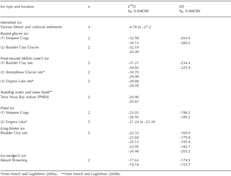
The isotopic composition (δ18O‰) of four samples of interstitial ice ranges between –4.78 and –27.72‰ (Table 1). These values plot very close to the global meteoric waterline (GMWL) (see Fig. 2) and there is no significant correlation with altitude or distance from the sea. For example, the two samples from Edmonson Point were sampled <100m from the shoreline but show the two extreme values, probably reflecting a mixing with sea water in one and the occurrence of glacial ice beneath the frozen material in the other.
Table 1 Isotopic values obtained from various ice samples collected from the Northern Foothills region
Buried Glacier Ice
Buried surface (glacier) ice is included in Russian ground-ice classifications (Reference ShumskiiShumskii, 1964) but has not been universally regarded as a ground-ice type in the North American literature, mainly because an intrasedimental origin has been proposed for the massive icy bodies that occur in the Tuktoyaktuk coastal lowlands (Reference RamptonRampton, 1988; Reference Mackay and DallimoreMackay and Dallimore, 1992). However, in the Antarctic context, we regard buried surface ice as legitimate and it is considered in this paper.
As might be expected in such a heavily glaciated region, our excavations indicated the widespread existence of massive bodies of ice lying beneath a thin surface veneer, 0.5–1.5m thick, of ablation till. Shallow drilling to depths of 8–10 m, and excavations using a jackhammer, indicate the ice is highly variable in composition. Typically, it is foliated and contains fine sediment layers (Reference GragnaniGragnani and others, 1998). In some instances, the ice is white, bubble-rich and without structure. Our impression is that much of the area of ablation till mapped by Reference BaroniBaroni (1987) is underlain by such ice. We assume the ice is of glacial origin and that its existence reflects the preservation potential of the cold Antarctic environment. For example, in the much warmer regions of western Siberia and northwestern Arctic Canada, massive bodies of Pleistocene glacier ice remain preserved beneath till (e.g. Reference Lorrain and DemeurLorrain and Demeur, 1985; Kaplanskaya and Tarnogradskiy, 1986; Reference French and HarryFrench and Harry, 1988). In the Northern Foothills region, natural exposures of buried glacier ice are rare but they have been observed on various occasions (i) at Adélie Cove, (ii) within debris-covered moraines adjacent to Boulder Clay Glacier, and (iii) within small glacier-ice-cored rock glaciers.
The ice has a wide range of δ18O‰ values. The less negative values are found at altitudes lower than 350ma.s.l., i.e. below the hypothetical Pleistocene upper surface of the ice at the Northern Foothills (Reference Orombelli, Baroni and DentonOrombelli and others, 1991). The most negative values were obtained from a sample on Mount Baxter, >50km inland from the coast and at an elevation of >1000 m. Below the upper limit of the Pleistocene glacier cover, as in the Boulder Clay area, isotopic values range between –7.82 and –32.19‰. As with ice-bonded permafrost, there are no significant linear relationships between altitude (and distance from the sea) and isotopic composition. Figure 2 shows that the buried ice samples plot along the GMWL.
Surface Ice
Also widespread are various forms of surface ice, also not usually classified as ground ice. These include perennial lake-ice covers, perennial snow banks and summer snow. All these ice bodies, when grouped with buried glacier ice, constitute surface ice of atmospheric origin that can be compared with traditional ground (i.e. subsurface) ice. Perennial lake ice in the study area is clean, with large bubbles oriented perpendicular to the surface. The lake ice has relatively low negative δ18O values, around –24‰, reflecting the isotopic composition of precipitation. In fact, the sample from Simpson Crags (830ma.s.l.) is slightly more negative than other determinations from samples closer to the coast. Fresh summer snow in the coastal areas usually has values ranging between –20 and –22‰ (see Fig. 2).
Ground (Subsurface) Ice
We recognize two types of traditionally defined, discrete, ground-ice bodies. These are: (1) wedge or vein ice, largely restricted to areas of pre-Late-Wisconsinan ablation till, and (2) intrusive ice, associated with the formation of small frost mounds that occur within a number of shallow perennially frozen lakes. Closely associated with some of these mounds are icing blisters, usually regarded as a form of surface ice. However, because the icing blisters are intruded within and through perennial lake ice, they are considered here as a form of intrusive ice. Both ice types are problematic and open to interpretation. Figure 3 shows examples of these various ice bodies and their topographic expressions.

Fig. 3. Photographs of ground ice and related phenomena, Northern Foothills region. (a) Frost mound at Boulder Clay Glacier. (b) View of the section dug on the mound shown in (a). (c) Details of an ice vein found in the Older Drift of Mount Browning. (d) Close-up of lake ice surrounding the mound shown in (a). (All photos by M. Guglielmin.)
Intrusive ice
A number of small debris-covered ice mounds that occur within, or at the borders of, shallow perennially frozen lakes have been interpreted previously either as ablation phenomena associated with debris-covered dead-ice terrain (Reference Orombelli, Baroni and DentonOrombelli and others, 1991) or, more recently, as a form of seasonal frost mound (Reference French and GuglielminFrench and Guglielmin, 2000a). We hypothesize that the latter would have formed by free-water injection from beneath the lake ice and the progressive uplift of debris from the lake bottom. Although the ice found within these mounds differs from buried glacier ice by virtue of an absence of foliations and/or debris layers, its isotopic composition is more similar to buried glacier ice, being typically in the range –28 to –31‰, than to either lake or icing-blister ice. However, Figure 2 shows clearly that the ice within the frost-heaved mounds lies along a line with a slope much lower than the GMWL, while buried ice lies along the GMWL. Therefore, we prefer to believe that the debris-covered mounds reflect differential ablation of the lake-ice surface and that lake-bottom debris has been progressively transported to the surface by a combination of basal ice accretion and free-water injection. Thus, the highly negative isotopic values reflect a combination of intrusion and segregation ice that formed at variable depth within the perennial lake-ice cover.
As might be expected, icing-blister ice is more similar in isotopic composition both to pond ice and to snow (see Reference French and GuglielminFrench and Guglielmin, 2000b, p. 311, Table 3), being in the range –22 to –25‰, than to frost-mound ice. In Figure 2, icing-blister ice lies along a line almost parallel to the GMWL but with δ18O values more negative (i.e. the line is above the GMWL). This may be indicative of open-system freezing with low evaporation plus, possibly, the addition of groundwater with more negative values.
Ice-wedge ice
Frost-fissure polygons occur widely on the Younger Drift terrain of the Northern Foothills (Reference BaroniBaroni, 1987; Reference Baroni and OrombelliBaroni and Orombelli, 1988). A few small ice wedges have been observed beneath some of the furrows (e.g. Reference French and GuglielminFrench and Guglielmin, 2000a, Fig. 6B; Reference Raffi, Stenni, Flora, Polesello and CamusoRaffi and others, 2003) and we agree with the general model proposed by Reference Marchant, Lewis, Phillips, Moore, Souchez and LandisMarchant and others (2002) for Beacon Valley, southern Victoria Land, concerning the formation of sublimation till and high-centered polygons. However, our observations suggest that a significant number of furrows in the Northern Foothills region are underlain by indistinct wedges of sandy and gravelly sediment. These are reminiscent of the sand wedges originally described by Reference PéwéPéwé (1959) from the McMurdo region.
In the Northern Foothills, high-centered polygons are present upon Older Drift terrain (i.e. pre Late-Wisconsinan sediments). We examined one ice body underlying a furrow, at 720ma.s.l. on Mount Browning, in late November 1998 (see Reference French and GuglielminFrench and Guglielmin, 2000a, p. 518–519). The upper part of the wedge contained few of the foliations typical of the ice wedges that one of us (H.M.F.) is familiar with from working extensively in the more humid, Northern Hemisphere permafrost regions. The ice yielded values of –17 to –18‰ (see Table 1; Fig. 2). These values are outside the –22‰ to –26‰ range reported for modern ice wedges and the –26‰ to –32‰ range reported for old inactive ice wedges in western Canada and Siberia (e.g. Reference MackayMackay, 1983; Reference MichelMichel, 1990; Vasil’chuk and Vasil’chuk, 1997, 1998). However, they are similar to values reported by Reference Raffi, Stenni, Flora, Polesello and CamusoRaffi and others (2003), and we suggest, therefore, that sublimation has occurred during the formation of the ice vein. Unfortunately, little more can be said conclusively at this stage about the significance of the isotopic value or the origin of the ice wedge.
Conclusions
A range of surface and subsurface ice bodies exist in the Northern Foothills. We have attempted to characterize them in terms of their isotopic composition. Surface ice bodies include buried glacier ice, perennial lake ice, ice within snow banks, and icing-blister ice. The amount of traditionally defined ground ice is small. Dry permafrost does not occur widely in the areas covered in this report. The origin of the ice contained within a number of small debris-covered mounds that occur within perennially frozen lakes is problematic. This ice has a δ18O composition that resembles buried glacier ice, but a deuterium excess value that is similar to associated icings and icing blisters. Considering the relationship between δ18O and δD values, the latter ice type appears unrelated to buried ice and probably reflects a freezing process associated with injection. We interpret the ice within the mounds to be a combination of intrusive and segregated ice.
Acknowledgements
Research was conducted under the auspices of the Italian Antarctic Research Programme (PNRA) (Project 2a.13, Professor F. Dramis, University of Rome 3) during the first period of the 1998/99 expedition. Field logistics were supplied by the PNRA station at Terra Nova Bay. Leave by H.M.F. from the University of Ottawa to participate in the 1998/99 expedition is gratefully acknowledged. Special thanks are given to the three anonymous reviewers who significantly improved the paper with their suggestions.


