


On one matter there is universal agreement: the appearance of practically every square metre in the Mediterranean today, save a few remote fastnesses, has been altered, directly or indirectly, by the past activity of people (Broodbank Reference Broodbank2013: 71).
Introduction
In Italy, archaeologists have, in the past, concentrated to a large extent on architecture and urbanism, and understandably so in light of the country's myriad surviving Classical-period monuments. There was, however, a shift in focus towards the investigation of regional multi-period change in the 1950s, not least through the initiatives of the British School at Rome in studying the landscape of south Etruria (Ward-Perkins Reference Ward-Perkins1961). More recent research has involved long-term studies drawing heavily on the results of field-walking survey and aerial photography to identify, date and characterise sites, and to record the results of these on distribution maps. Over the past three decades, fieldwork of this kind has produced vast amounts of new information, often overturning previous ideas and prompting new archaeological or historical questions. Field-walking survey has been shown to be a very effective method for detecting artefact-rich surface contexts and phases. Serious limitations have also been revealed, however, in the effectiveness of the method at detecting particular phases of past activity, or in revealing the ‘connective tissue’ of fields, communication routes and minor settlements (Campana Reference Campana, Campana and Piro2009; Vaccaro et al. Reference Vaccaro, Bowes, Ghisleni, Grey, Arnoldus-Huyzendveld, MacKinnon, Mercuri, Pecci, Cau Ontiveros, Rattigheri and Rinaldi2013). Despite the achievements of this kind of survey, we are often left with apparent gaps, both ‘empty spaces’ and ‘empty phases’, within which we know little or nothing about what was happening in the open countryside. For all its merits, field-walking survey will never provide access to these essential elements of the landscape pattern—the ditches, pits and other features left by modest and ephemeral acts of past societies.
On the other hand, the rapid development of large-scale geophysical prospection has added a new and highly effective tool for detecting, characterising and explaining at least some of the anthropogenic features within this rural ‘emptiness’. This helps to reveal aspects of the past that have previously remained hidden. In Britain alone, for example, we need only mention the ‘vanished’ Roman town at Aldborough, North Yorkshire (Ferraby & Millett Reference Ferraby and Millett2016), the prehistoric landscapes of Salisbury Plain (Gaffney et al. Reference Gaffney, Gaffney, Neubauer, Baldwin, Chapman and Garwood2012) or the seemingly uninformative Vale of Pickering in North Yorkshire, now revealed as a densely populated multi-period landscape spanning from prehistory through to the Medieval period (Powlesland Reference Powlesland, Campana and Piro2009).
The archaeological and historical vistas opened up by these projects, and the new archaeological and historical questions that they invite us to explore, are not just paralleled by the capacity of airborne laser scanning to reveal human elements in the open landscape, but also to ‘cut through the trees’ of wooded areas to reveal preserved features and landscapes beneath the woodland canopy. These techniques have already been tested to good effect in urban contexts (Vermeulen et al. Reference Vermeulen, Burgers, Keay and Corsi2012), but can we expect similar results from the same techniques in the rather different environmental and cultural realities of Italy and the Mediterranean countryside?
The Emptyscapes project
The research described in this article was aimed at stimulating changes in the way in which archaeologists, in Italy in particular but also more generally throughout the Mediterranean, study the archaeology of landscapes. It moves on from an essentially site-based approach to a more comprehensive ‘landscape’ perspective. This is one of the first attempts in Italy at an avowedly holistic approach, encompassing many different methodologies to reconstruct the evolution of cultural and environmental landscapes, from the prehistoric to medieval periods in southern Tuscany and northern Lazio. The resultant picture is predictably less about ‘sites’ than about a populous landscape in the social, economic and environmental sense, with field systems, communication and trade networks, and industrial and agricultural foci in addition to domestic settlements. The key aim was to find a new balance—assuming there ever was one—between ‘site’ and ‘off-site’ archaeology, bridging the two categories, or expanding the concept of the ‘site’ to encompass a much wider catchment area—a block of landscape that might vary in size, both regionally and across time (Bintliff Reference Bintliff, Bintliff, Venclova and Kuna2000).
Clearly, the size and position of such a landscape could be influenced by theoretical approaches or specific archaeological or historical questions. Working systematically on landscape blocks of this kind, filling in gaps between identifiable ‘sites’, could, in favourable circumstances, make it possible to achieve what we call ‘the archaeological continuum’. We define this as the sum total of the evidence detected (or detectable) within the area under examination, reducing spatial and chronological gaps as much as possible by applying a wide variety of exploratory and analytical methods. The archaeological interpretation resulting from this approach could be expected to reveal differing layers of various chronological horizons.
Two study areas were chosen for the Emptyscapes project. The first was the interior of the ancient Etruscan and Roman city of Veii, north of Rome, where fieldwork and analysis over the past decade have established a reliable approach to the study of a now rural but once urban site. The second, discussed in this article, was a stretch of lowland rural landscape near the ancient city of Rusellae in southern Tuscany, breaking completely new ground in the exploration of what could reasonably be characterised as a rural ‘emptyscape’ (Figure 1). The present article concentrates on the second of these study areas, the work at Veii being reported elsewhere (Francovich & Hodges Reference Francovich and Hodges2003).

Figure 1. Location of the Rusellae and Veii study areas and other relevant sites in central Italy. The administrative regions of Tuscany and Lazio are delineated in dark grey.
The Etruscan and Roman city of Rusellae has been relatively well explored archaeologically, with a site history comprising well-defined phases of foundation, elaboration and decline from the eighth/ninth centuries BC to the early twelfth century AD, when primacy and the local bishopric were ceded to the growing town of Grosseto, a few kilometres to the south-west. At least some of the developments within the hilltop city are known or suspected to have been matched by developments or transformations within the open landscape of the valley below, including the foundation and decline of rural villas, and (possibly) the process of centuriation (the typical layout of a Roman field system) during the Roman period. Villages of one kind or another may also have been present during the Iron Age and early medieval periods, although their location and form remain unclear (Nicosia & Poggesi Reference Nicosia and Poggesi2011).
Today, the slopes to either side of the valley are largely wooded. The relatively flat and topographically undistinctive landscape between present-day Grosseto and the site of Rusellae now displays a rotating mixture of arable cultivation and pasture, dotted with small areas of woodland, vineyards and olive groves. A trapeze-shaped sample transect covering 2500ha of the valley and hillslopes to the south-east of Rusellae was chosen as offering opportunities to explore a range of environmental and archaeological contexts, with lowland fields appropriate for magnetic survey flanked by wooded hillslopes, which in due course will act as a test-bed for high-resolution laser scanning.
Previous field survey, aerial photography and the detection of archaeological evidence
From the late 1970s onwards, the University of Siena has fostered a systematic programme of landscape and archaeological investigation within southern Tuscany, including the Rusellae area. As a result, the area now has a substantial database and GIS record, developed mainly through the examination and analysis of archaeological evidence and ancient literature comprising documentary and epigraphic sources, place-name evidence, systematic field-walking survey and aerial photography, and excavations at various scales.
Despite this, many important archaeological questions remain unresolved. For instance, within Tuscany as a whole, as in other intensively studied Italian regions such as Puglia and Lazio, between 90 and 95 per cent of the evidence recovered so far relates to the time span between the sixth century BC and the sixth century AD. The prehistoric period and Middle Ages are thus poorly represented within our present record. Material culture, of course, changes over time, but the physical manifestation of settlements, communication systems and agricultural patterns, while sometimes modest and ephemeral, can also be more substantial and long-lasting in character. The trappings of everyday life in one period may be highly durable, with well-made and hard-fired pottery, for instance, but such things may have been radically different in the preceding or following phases, with the use of poor-quality clay, inadequate firing or even the abandonment of durable materials such as stone or ceramics in favour of wood or other perishable materials. Different cultures may therefore present differing levels of archaeological ‘visibility’ when viewed through the medium of material brought to the surface by ploughing or other forms of disturbance.
The less intensive incidence of a culture in a particular context, and the less durable character of the materials associated with it, can give rise to fundamental difficulties in recognising their archaeological signature. A review of previous research shows a clear correlation between periods characterised by less durable material culture (certain prehistoric phases, the protohistoric and the medieval periods) and seemingly poor results from field-walking survey. Moreover, reflection on these issues led us to the conclusion that field-walking survey and artefact collection could be generalised as relatively efficient for the identification of so-called ‘positive evidence’ (such as stone or brick walls, concrete floors, tiled roofs or other structural elements made of durable materials), but virtually worthless for detecting ‘negative evidence’ (such as ditches, pits, postholes or features made of perishable materials).
Hence, if we upscale from the 1:100000 distribution map of ‘traditional’ evidence for the Rusellae area (Figure 2) to the 1:10000 representation of part of the Emptyscapes study area (Figure 3), it is easy to appreciate how the ‘empty spaces’ predominate. This realisation raises a crucial question: what are we missing? The answer lies before our very eyes: the landscape and its transformations across time.

Figure 2. Diachronic distribution map of the Rusellae area at a scale of 1:100000, showing the results of three decades of archaeological survey and mapping (yellow dots) and the main central places (red dots). The area within the trapezoid outline of the Emptyscapes study area has been systematically field-walked. The extent of Lake Prile, which gradually shrank from the first millennium BC until the end of the Middle Ages, is shown in solid colour.

Figure 3. Distribution map of the north-eastern end of the sample transect at a scale of 1:10000, showing sites detected by ‘traditional’ archaeological survey methods.
The Emptyscapes project has sought to address the conundrum of the ‘empty phases’ and ‘empty spaces’ by conducting an intensive study of the sample transect to explore some key questions relating to the major cities of Rusellae, Grosseto and Vetulonium. Issues for consideration include the urbanisation of the Etruscan cities, and in particular, their relationship with the surrounding countryside; the Romanisation of the cities and the landscape; and the process of Christianisation and its impact on settlement, society and economy at the end of antiquity and the beginning of the Middle Ages. To help address these issues, we have so far collected around 400ha of geophysical data (370ha of magnetometry and 30ha of resistivity data) from the sample transect, undertaken exploratory aerial survey in the area and recently commenced fieldwork to collect archaeological, geoarchaeological and bioarchaeological evidence (Figure 4).

Figure 4. Map of the Rusellae study area (at a scale of 1:100000) summarising (in dark grey) the present extent of large-scale contiguous geophysical survey within the trapezoid sample transect. Lowland areas are shown in white and higher elevations are shown in increasingly dark shades of grey.
The systematic examination of previous archaeological literature, documentary sources, epigraphic material, place-name evidence and historical maps, combined with a long-lasting programme of field-walking survey, has produced a substantial amount of information on the Rusellae area—establishing around 80 archaeological contexts of various kinds within the transect that are now under intensive study (Figure 2). Moving from the 1:100000 scale of Figure 2 to the more detailed representation at 1:10000 in Figure 3, however, it is quite clear that even the most dense concentrations on the 1:100000 map display large ‘gaps’, even at this higher-resolution scale. We must, of course, be cautious in comparing the results of this ‘traditional’ research with the wider range of information collected through remote sensing (mainly aerial photography) and geophysical prospection. Nevertheless, the general increase in the visibility of archaeological remains can be seen in the fact that the latter methods have so far detected 1886 identifiable pieces of evidence within the sample transect. That said, the qualitative value of the data must not be overlooked for the purposes of holistic landscape interpretation. With this goal in mind, we can usefully look at parts of the sample transect in closer detail, and highlight some of the results achieved so far.
The north-eastern part of the sample transect
At present there are two main blocks within which we have collected large-scale contiguous magnetic data, one in the south-west and the other to the north-east (Figure 3). The block in the north-east is so close to the town of Rusellae that it might have been viewed as both a suburban and rural area during the city's lifetime. Here, aerial survey, and magnetic prospection especially, have produced entirely unexpected results. For instance, close to the south of Rusellae, in an area of superficially indistinctive arable landscape, a mass of magnetic anomalies are clearly visible (Figures 5 & 6). These represent a major road, bounded on either side by a dense concentration of ring-ditches, and rectangular anomalies interpreted as burials—in effect, a major cemetery, probably dating to both the Etruscan and Roman periods. On the basis of comparative studies of other Italian regions such as Cerveteri (Tartara Reference Tartara and Guaitoli2003), this is clearly a major (and previously unknown) funerary landscape located along one of the main roads entering and leaving the city of Rusellae. Moreover, on the southern (lower) edge of Figure 6, another road and a peculiar structure (the round anomaly surrounded by a square of opposite polarity) bears a clear parallel to many Roman mausolea (Johnson Reference Johnson2014). This interpretation allows us to envisage the fascinating scenario of a funerary landscape exhibiting a degree of continuity from as early as the sixth or seventh century BC up until some point in the Roman period, perhaps with links to the developmental stages of the city itself. Surprisingly, in light of the geophysical evidence, neither micromorphology nor field-walking surveys have in any way previously suggested the presence of this important and apparently long-lasting landscape.

Figure 5. Overlapping of the site distribution (from Figure 3) and archaeological mapping of magnetic measurements (Mag), as well as oblique (oAP) and vertical (vAP) aerial photography. Scale: 1:6000.

Figure 6. Geophysical data from the north-eastern part of the sample transect. Top) view of the surveyed area looking east; middle layer) detail of the surface of the area under investigation, showing the total absence of artefact scatters or any other evidence of the funerary landscape detected by magnetic measurements; bottom left) detail of the magnetic map showing the features interpreted as a possible mausoleum; bottom right) map of the magnetic data survey showing the ring-ditches and square anomalies interpreted as part of a major funerary landscape. The conjectured mausoleum appears at small scale in the bottom left of the map.
A few hundred metres to the south-west of Rusellae, the magnetic data show a cluster of anomalies that can be readily interpreted as both anthropogenic and natural components of the local landscape: cultivation patterns, road systems, buildings and geomorphological features. Within this complex there lies a double-ditched enclosure (marked in blue in Figures 7, 8 and 9) alongside the present course of the river Salica. The enclosure was first identified in the magnetic data, and later confirmed through intensive field-walking survey.

Figure 7. The double-ditched enclosure alongside the river Salica. Bottom left) view of the surveyed area looking north showing the magnetic data; bottom right) ground-level view of the site with elevated landscape topography visible in the background; bottom right mapping of the archaeological and geomorphological features including the double-ditched enclosure and its internal features along with the geomorphology and road and field systems of the surrounding landscape.

Figure 8. Ditched settlements within the Rusellae sample transect. Top left) Brancalete, close to Aiali, blue and green polygons showing evidence of the mound and ditched area; top right) circular settlement also near Aiali, green circular polygons showing evidence of the ditches; bottom) archaeological features identified from the magnetic data and aerial photographs, superimposed on the cadastral map of 1817–1830. The field patterns in the cadastral map appear to have almost no connection with the patterns identified in the magnetic data.

Figure 9. The double-ditched settlement alongside the river Salica. Top) total density plot of surface artefacts in sherds per grid cell collected during field-walking and the borehole survey transect. Bottom) distribution of artefact scatters across time, from Late Antiquity to the early tenth to the early or mid twelfth century AD.
Within the 0.8ha central area of the enclosure, intense artefact scatters coincided with a number of clear magnetic anomalies, the size and shape of which suggested their interpretation as buildings. A larger east–west anomaly to the north might represent a church. In this case, field observation and artefact collection were critical in identifying key features of the site, including a significant change in elevation (as much as 1.5m) relating to many of the features visible in the magnetic survey data (Figure 7), and artefact scatters (Figure 9), which, upon investigation, clearly indicate a medieval dating.
A previously unknown artificial mound, possibly a settlement occupying a slight natural eminence within the local topography, has also been revealed here. Moreover, in the nearby vicinity of the site, mostly to the south and west of the river Salica, magnetic anomalies revealed a pattern of field boundaries, roads and palaeochannels. The outstanding character of the magnetic data and local topography prompted a borehole survey, and an intensive programme of artefact collection within a virtual grid of 239 10m × 10m cells. These were intended to help establish the chronological range and function of the site, and provide a more detailed picture of the relationship between magnetic measurements, micromorphology and artefact distribution. Analysis of the collected artefacts showed a distinct pattern of intensive human activity, predominantly during the early tenth to the early/mid twelfth centuries AD. On the basis of comparative studies of shape, size, morphology, artefact assemblage and chronological range, this site can be interpreted with confidence as a lowland medieval settlement. It shares significant characteristics with three others identified during recent survey work close to or within the Grosseto lowland; the adjacent field system and roads may well be associated with the same cultural context and chronological range.
The parcels within the field system are characterised by a relatively consistent pattern of size, shape and boundary type. The boundaries were clearly ditches, no doubt serving to divide the land into functional units, while at the same time providing drainage for arable land close to the river Salica. Unfortunately, the borehole survey proved ineffective in providing reliably datable samples. Consequently, a programme of test excavations is needed to improve further our understanding of the field boundaries. In the meantime, comparative studies have shown clear resemblances to sites in Puglia, revealed in the first instance through aerial photography (Guaitoli Reference Guaitoli2003). Many of them share a similar general appearance to our field system in terms of size, shape and overall pattern, and in some cases, also to the shape of the settlements themselves.
Of the 25km2 extent of the sample transect, 15km2 consists of valley lowlands. Within this, an area of 4km2 has so far been subjected to intensive survey, revealing the presence of two other enclosures in the Grosseto area (Figure 8). When the size of these enclosures is taken into consideration, they represent a density of one such settlement for each 1.3km2 of the closely examined area. A larger area will obviously need to be covered before such a statistic becomes truly meaningful across broader stretches of landscape. This rate of recovery is nevertheless significant in the context of the research history of the area. In the past 40 years, the archaeological development of Tuscany has been intensively studied by traditional means, including excavation and field-walking survey, most notably by archaeologists from the University of Siena, and especially those under the leadership of the late Riccardo Francovich. A key concept resulting from this work has been the recognition of the long-term development of fortified hilltop villages, a process known as incastellamento (Francovich & Hodges Reference Francovich and Hodges2003). Very few settlements of any kind had been identified in lowland Tuscany prior to 2005, however, and none of the type now coming to light in the Rusellae area (Campana et al. Reference Campana, Francovich, Marasco, Campana and Forte2006; Vaccaro Reference Vaccaro2012).
The reason for this clearly lies in the incapability of field-walking survey to detect ‘negative evidence’ (Campana Reference Campana, Campana and Piro2009). The discovery of this unexpected category of settlement is bound to stimulate discussion on how to integrate this new information into the historical concept of incastallamento in ways that will improve our understanding of landscape transformations between Late Antiquity and the mature Middle Ages, not least in the interplay between the strength and strategies of the ruling classes, and the continuing existence of functioning communities and settlement patterns within the Tuscan countryside (Creighton Reference Creighton2012; Settia et al. Reference Settia, Marasco and Saggioro2013; Bianchi Reference Bianchi, Gelichi and Hodges2015). Perhaps we could envisage a new scenario in the Rusellae area. The enclosure alongside the river Salica could be interpreted as the result of at least two different processes. If the presence of a few early medieval sherds is dismissed as merely residual, the settlement could then be considered as a new foundation of the early tenth century AD, rather than as the outcome of a longer-term process of the kind envisaged within the incastellamento model. In that case, it may be supposed that at this point in time, the ruling classes invested resources in developing new settlements on the fertile lowland, perhaps moving the population into the area from elsewhere. On the other hand, if this small amount of early medieval pottery is interpreted as deriving from a development initiated by some sort of community already living in or around this area, then the social and economic processes involved could have been quite different. The answer to this conundrum can only come through excavation, preferably on a fairly extensive scale.
The settlement, and particularly the field system (if the two are genuinely associated with one another), illustrate an extraordinary, vital stage of a society that had the capacity, if not the need, to reorganise settlement and landscape patterns, perhaps removing almost all vestiges of older settlement or cultivation traces in the process. Finally, it is perhaps worth noting the geomorphological complexity of the area under investigation. Past studies identified this as one of the most important areas within the Grosseto plain for agricultural production (Citter & Arnoldus Reference Citter and Arnoldus2007). Moreover, the present survey has produced clear evidence of a high level of hydrogeological instability related to old riverbed systems in this locality. Therefore, the creation of this new settlement and field system, whether financed initially by the ruling classes, or undertaken by an existing rural community of their own volition, would have required advanced knowledge of the local area, along with social resources in terms of labour and productive capacity, to fulfil the project in the first place and to retain viability as a social and productive concern over time.
The south-western part of the sample transect
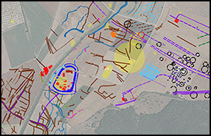
In the south-west of the sample transect is the second large block of intensive landscape survey (Figures 3 & 10). In this area, too, the quantitative results are remarkable. Previous surveys had identified 19 sites (17 on-site and 2 off-site). Magnetic and electrical resistance survey and aerial photography have now revealed a dense pattern of 883 features ranging chronologically from the Etruscan period through to the Middle Ages, and including settlements, field systems, enclosures, graves, road systems and geomorphological features. In this area, a particularly important complex near the location of the barn-house at Aiali was identified in 2001 (Musson et al. Reference Musson, Palmer and Campana2013). Oblique aerial survey revealed a large building complex that was subsequently investigated through an intensive collection of surface artefacts and various forms of geophysical survey to shed light on a massive rural settlement, about 4ha in extent including open areas, and with an occupation spanning from the late Republic to the Middle Ages (Campana & Piro Reference Campana and Piro2009).

Figure 10. The south-western area of the sample transect, with yellow dots marking the results of the ‘traditional’ archaeological investigation, superimposed on interpreted remote sensing and GIS data. Top left) close-up of the buildings of the Roman complex (1, 2 and 3), a medieval feature (4), a double-ditched medieval enclosure (5), the ancient field system (6), which matches the orientation of Roman buildings (2) and (3), and a major road (7).
The Roman complex, as illustrated in Figure 10, lies either side of a seemingly major road linking this area to Rusellae, situated about 4km to the north-east. This is clearly an advantageous position within the landscape, alongside Lake Prile, close to Rusellae and with the mansio (posting-station, typically spaced one's day journey apart) at Hasta, an additional 18km away to the south.
Further significant features include a clearly organised and roughly grid-like field system, oriented north-west to south-east. Artefact collection across this area has provided provisional dating for the buildings and other features within the complex. The southern (and later) buildings (2) and (3) in Figure 10 are clearly parts of a villa complex, oriented in a manner that is in keeping with the field system; the earlier northern building (1) is not oriented on this alignment. There is also an early medieval building in the same area (4), as well as an early medieval, rectangular ditched enclosure (5) a few hundred metres to the south-east (Figure 10). The ditched settlement is oriented in broad alignment with the field system, suggesting the possibility of some form of continuity in the organisation of the landscape from the Imperial Roman age through to the early medieval period.
Within the field system, the average size of the parcels is very close to the Roman iugerum (2519.9m2), or multiples thereof, but the pattern is fairly uneven, as might be expected if the system remained in use for many centuries after its creation during the Roman period. Local historians have attempted to identify a pattern of centuriation in this area, but their hypothesis awaits confirmation (Mazzolai Reference Mazzolai1960; Prisco Reference Prisco1998); in any case, their supposed pattern does not match either the field system or the other features described here. It is too soon to claim, on the basis of orientation and field-system size unit, that the recently revealed fields represent a centuriation system set out in the mid-Imperial age and remaining in use until early medieval times. For the moment, the question of dating and derivation remains unresolved, at least until test excavation or further geophysical prospection can provide a secure guide to the chronological range and extent of the recently revealed field system.
Conclusions
The survey and interpretation described above have demonstrated the potential of this multi-method approach for the investigation of rural landscapes in central Italy. By extension, such an approach should reap promising results elsewhere throughout much of the Mediterranean area, showing clearly that the concept of the archaeological continuum is indeed a reality that lies almost within our grasp. Moreover, the results achieved so far within the Emptyscapes project make it realistic to draw a comparison between approaches to landscape investigation and archaeological excavation. The progressive move away from trenching to open-area excavation finds a good parallel in the move from ‘site’ to more broadly based ‘landscape’ archaeology of the kind described here.
Previous research strategies in Italy have largely been reactive, with a focus on the known, or partly known, through the use of methodologies that reveal only a limited proportion of the potentially recoverable evidence. Archaeological distribution maps, particularly for the Rusellae area, consisted, until very recently, of a collection of dots within a sea of ‘emptiness’. If we can overcome this limitation, as has been demonstrated here, new opportunities to explore a wide range of as yet unanswered archaeological and historical questions may open up ahead of us.
Ultimately, the capacity to uncover and document previously inaccessible evidence is important for two key reasons, the first being essentially archaeological while the second is methodological. For instance, the identification of a previously unsuspected funerary landscape, of field systems, enclosures or structured medieval settlements around Rusellae cannot be disregarded as more dots or detail on the mapped record of the area. The newly discovered enclosures represent a form of settlement previously unknown in the archaeology of lowland areas of Tuscany (Settia et al. Reference Settia, Marasco and Saggioro2013). The prevailing concepts of recent decades, of a largely ‘uninhabited’ Tuscan countryside in the formative centuries of the medieval period, have thus been thrown open to discussion. Speculation as to the role that the ruling classes or the local communities of the countryside played in the inception and development of this kind of rural settlement has also been invited. That said, we must clearly wait until the results from this ongoing survey work have brought together a greater quantity of high-quality data to facilitate a better understanding of the Italian landscape in the longue durée.
The results achieved are also important methodologically. Similar advances in data capture and archaeological understanding have ensued wherever new holistic approaches to landscape studies have been applied, both in the UK and in continental Europe. The results from Rusellae show that the same combination of traditional and innovative methodologies offer great potential for progress for the archaeology of Italy in coming years. This new methodology will enable us to examine, and possibly revise, present perceptions about both the content and the progressive transformations of the Italian countryside.
Acknowledgements
The research for this paper was funded by the European Union through the Marie Curie action (Emptyscapes) and the Culture 2007 ArchaeoLandscapes project. I continued the research at the University of Cambridge as Fellow of the Faculty of Classics and Fellow of the McDonald Institute for Archaeological Research. I am particularly grateful to Martin Millett, scientist-in-charge of the Emptyscapes project, and to Ken Saito for gathering and processing vast amounts of magnetic data. Thanks also go to (in alphabetical order): Giovanna Bianchi, Michel Dabas, Charles French, Gianfranco Morelli, Andrea Pessina, Salvatore Piro, Gabriella Poggesi, Simon Stoddart, Emanuele Vaccaro and Frank Vermeulen. A special debt is owed to two good friends who have followed and inspired so much of my research work since early in my career: Chris Musson and Dominic Powlesland.


