


Introduction
Marine sediments from the seas around Antarctica are important sources of information on Antarctic environmental changes. The sediments of the Ross Sea, one of the large inlets of Antarctica, have been researched in a number of scdimentological, oceanographie and micropaleontological studies (e.g. Reference Kellogg, Osterman and StuiverKellogg and others, 1979; Reference Anderson, Brake and MyersAnderson and others, 1984; Reference Edwards, Lee, Karl, Reimnitz, Timothy, Cooper and DaveyEdwards and others, 1987; Reference DeMasterDeMaster and others, 1992), and the recent history of the Antarctic ice sheet has been reconstructed in several studies of this region (e.g. Reference Denton, Bockheim, Wilson and StuiverDenton and others, 1989; Reference Anderson, Kennedy, Smith, Domack, Anderson and AshleyAnderson and others, 1991). Our previous research has distinguished two types of sediment sequences on the Ross Sea continental shelf: continental-shelf break and continental-shelf facies (Nishimura and others, 1996). The continental-shelf sequence consists of two distinct lithologics: upper diatomaceous mud formed under modern conditions and lower consolidated sandy silt probably of Glaciol origin. The heavy mineral distribution in the surface sediments suggests that icebergs transported sand grains to the area, controlled by surface currents in the Ross Sea (Reference Tokuhashi, Agyingi and NishimuraTokuhashi and others, 1996). in 1995 we obtained three new cores from the western margin of the Ross Sea continental shelf during a Japan National Oil Corporation (JNOC) research cruise.
In this paper, we describe these cores and infer paleo-environmental conditions in the western Ross Sea based on sedimentological and micropaleontological data, and accelerator mass spectrometer (AMS) l4C dating of the cores.
Geologic Setting
The continental shelf of the Ross Sea is up to 600 m deep, with several north-northeast south-southwest trending banks and troughs. These topographic features result from the structures of sedimentary basins and Glaciol erosion in the Quaternary (Reference Davey, Cooper and DaveyDavey, 1987). The shelf break of the Ross Sea is relatively deep (![]() 800 m), and the greatest depths on the shelf occur landward near the ice shelf (Reference Chriss, Frakes and AdieChriss and Frakes, 1972). The western margin of the Ross Sea continental shelf is bounded by theTransantarctic Mountains and a deep trough, the Drygalski Basin, present along the coast with a northeast-southwest to north-northeast south-southwest trend. To the east of the troughs, there are shallower banks and islands, such as Crary Bank, Franklin Island and Beaufort Island, from north to south. The present ice shelf is south of 77.5° S in the western Ross Sea. Drygalski Ice Tongue extends eastward to 165° Ε along 75.51 S.
800 m), and the greatest depths on the shelf occur landward near the ice shelf (Reference Chriss, Frakes and AdieChriss and Frakes, 1972). The western margin of the Ross Sea continental shelf is bounded by theTransantarctic Mountains and a deep trough, the Drygalski Basin, present along the coast with a northeast-southwest to north-northeast south-southwest trend. To the east of the troughs, there are shallower banks and islands, such as Crary Bank, Franklin Island and Beaufort Island, from north to south. The present ice shelf is south of 77.5° S in the western Ross Sea. Drygalski Ice Tongue extends eastward to 165° Ε along 75.51 S.
The deeper (>300m) basins of the Ross Sea continental shelf are covered by muddy sediments, whereas shallower areas are covered by coarser (sand and gravel) deposits, reflecting sediment sorting by bottom currents ( Anderson and others, 1984; Reference McCoy and HayesMcCoy, 1991). The muddy sediments in the deeper portions consist of terrigenous fine silt and clay, and silk cons biogenic material containing poorly sorted ice-rafted debris (Nishimura and others, 1996).
Materials and Methods
The sediment core samples used in this study were collected from the western margin of the Ross Sea (Fig. 1; Table 1) during theTH95 Antarctic Cruise in 1996 conducted by the Technology Research Center, JNOC, using R/V Hakurei-Maru. A gravity corer with an 11 cm diameter and 5.4 m long was used, but the recovered core lengths were shorter because of the presence of hard substrata in the shallower

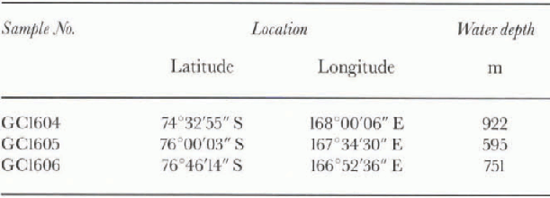
Fig. 1. Map of the western Ross Sea continental sheif Antarctica, showing the sampling locations.
Table 1. Location data for core samples in the western Ross Sea
subsea floor. Site GC1604 is situated on the northwestern slope of Crary Bank, east of Mount Melbourne; site GC1605 is situated near Franklin Island; and site GC1606 is located north of Ross Island.
Our shipboard and shore-based studies consisted of seven components:
-
(1) Descriptions of sediment lithologies based on visual observation, soft X-ray photos and smear slide observations.
-
(2) Water content (weight percentage water) and dry bulk density were measured for syringe samples of 4-5 cm3 at 10 cm intervals.
-
(3) Sand contents (weight percentage of grains larger than 63μm) were measured for the syringe samples.
-
(4) Magnetic susceptibilities were measured for 1 in3 (16 cm3) samples at every inch (2.54 cm) using a MartisonType-2 apparatus in 0.47 and 4.7 kHz frequency modes. Magnetic susceptibility profiles may be used to infer content of terrigenous materials in the sediments. The frequency dependencies were calculated from the differences of measured susceptibility values between the two modes, and those values suggest the grain-sizes of magnetic minerals (Reference Yamazaki and KatsuraYamazaki and Katsura, 1990):

XFD is the frequency dependence, X L is the magnetic susceptibility of 0.47 kHz frequency and AΉ is the magnetic susceptibility of 4.7 kHz frequency
-
(5) Organic carbon contents were measured at 10-20 cm intervals. Samples were stored frozen before drying at 50°C. Bulk carbon contents were measured using a Yanako CHN analyzer; the bulk carbon contents are assumed equal to organic carbon contents, because the inorganic carbon contents of several survey samples are less than 0.04%.
-
(6) Diatoms were analyzed at 20 cm intervals using unprocessed strewn slides (Reference AkibaAkiba, 1982). One hundred diatom specimens were identified along with resting spores.
-
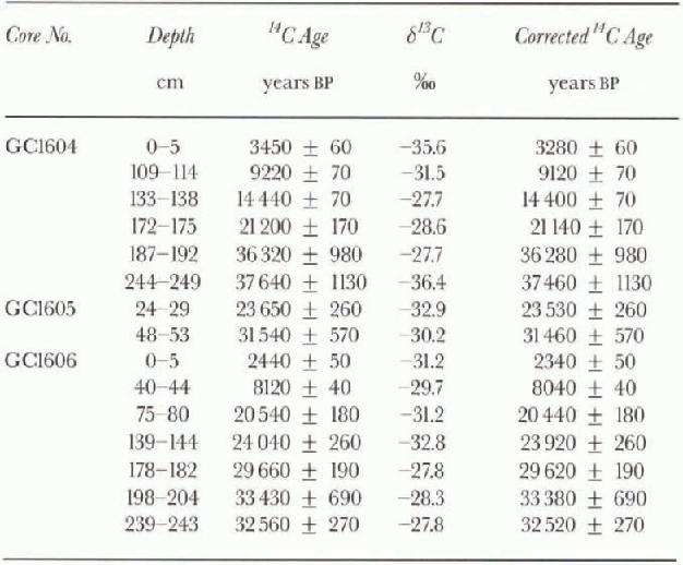
(7) Acid-insoluble organic carbon was used for AMS l4C dating. C ages (table 2) are corrected for isotopic fractionation based on 13C/12C ratios, using a half-life of 5568 years. The AMS measurements were performed at Groningen University, The Netherlands, after preparation at Beta Analytic Inc., U.S.A. Fifteen dates are available for these three cores (Table 2; Fig. 2). We have not made corrections for G reservoir effect. Wc suggest deducting at least 2 ka from our C ages, because of core-top ages of about 2 and 3 ka BP.
Table 2. Table 2. AMS age data of the organic carbon in cores GC1604, GC1605 and GC1606 from the western Ross Sea
Core Lithologies
In the core sequences, we distinguished three lithologie units, I, II and III in descending order. Unit II is subdivided into unit IIA and IIB. The simplified lithologies and characteristics of the sediments are shown in Figure 2. The results of diatom analysis are shown in Figure 3.
1. Unit I
Unit I includes 0-109 cm in GC1604, 0-14 cm in GC1605 and 0-55 cm in GC1606.

Fig. 2. Lithologies, physical properties, sand contents, carbon contents and AMS14 Cages of the core samples from the western Ross Sea.
Lithology
Unit I is dark grayish yellow to gray olive diatomaceous mud with about 10% sand-sized grains. Water contents are generally high, averaging 60%, and gradually decrease down-core. Organic carbon contents are high, exceeding 0.7%.
Age
This unit is younger than 9kaBF in two of the cores, with average sedimentation rates of 0.187 mm a−1 for GC1604, and 0.060 mm a−1 for GC1606. Extrapolated core-top ages for GC1604 and GG1606 are about 3 and 2 ka, respectively.
Diatoms
This unit has abundant well-preserved diatoms, with a predominance of Nitzschia curta, accompanied by Thalassiosira antárctica. These two species exceed 70% of the total in this unit.
2. Unit IIA
Unit IIA corresponds to 109 175 cm in GC1604; it is not observed in the other cores.
Lithology
Unit IIA is dark greenish gray mud, with water contents decreasing downward from 62% to 52%. Organic carbon contents decrease downward from 0.8% to 0.3%. Volcanic glass is abundant from 109 to 140 cm of this unit.
Age
The age of unit IIA is about 22 9 ka UP, with a sedimentation rate of 0.056 mm a−1.
Diatoms
The assemblages of unit IIA are similar to those of unit I, with the presence of Nitzschia kerguerensis and Paralia sulcata. though the diatom contents are smaller than those in unit I. Resting spores are abundant in the lower part of this unit.
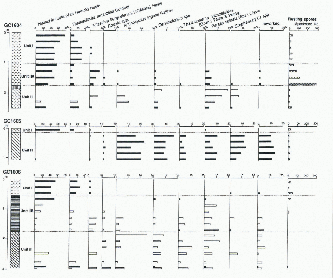
Fig. 3. Diatom distribution in cores GC1604, GC1605 and GC1606 from the western Ross Sea. Percentages of species were calculated based on identification of 100 specimens (black filled pattern) or less than 100 specimens (gray pattern). Lithologie patterns are the same as those in Figure 2.
3. Unit IIB
Unit IIB corresponds to 55-173 cm in GG1606: it is not observed in the other cores.
Lithology
Unit IIB has an alternation of clay and thin (mm scale) laminated silt. Water contents vary greatly between 73% and 24%, and contents of sand-sized grains are low. Organ-IC carbon contents are 3-1%. Magnetic susceptibility is lower, and frequency dependence is greater than in the other units, which suggests that smaller magnetic grains are dominant in this unit. Several minor fault structures, apparently normal, are observed in several thin laminae of this unit.
Age
The age of unit IIB is 26-19 ka BP, with a sedimentation rate of 0.20mma−1.
Diatoms
The assemblages of unit IIB are the same as those of unit IIA, though the contents of N curta and T. antarctica are distinctively low. Reworked specimens are observed in this unit.
4. Unit III
Unit III includes 175-254 cm in GC1604, 14-107 cm in GC1605 and 173-296 cm in GC1606.
Lithology
Unit III is composed of consolidated dark olive gray to dark greenish gray silty sand to gravelly sandy silt, with low water contents of 18-30% and high contents of sand-sized grains exceeding 30%. Organic carbon contents are < 0.2%. The upper part of this unit in GC1605 is more consolidated than the lower part. Nearly all diatoms in the smear slides of this unit are fragmented.
Age
In GC1604, the two age dates in this unit are 36 280 and 37460 years BP, with an apparent sedimentation of 0.483 mm a−1, and the top of this unit is probably about 36kaBP or younger. Dates of GC1605 indicate that this unit is about 20-30 ka BP, with a sedimentation rate of 0.030 mm a−1. The ages of this unit of GC1606 are about 30-33 ka BP, and the middle and lowest age data are stratigraphically reversed.
Diatoms
This unit is composed of poorly preserved specimens of Ac-tinocyclus ingens, P. sulcata, Stephanopyxis spp., and Denticulopsis spp. Reworked specimens including extinct species are observed in this unit.
Paleoenvironmental Reconstruction
The lithologie units can be used to infer the following environmental conditions for the three sites:
-
(1) Sediments loaded by a grounded ice sheet. Unit III has the same characteristics at all sites: high consolidation, lithologies of sandy silt with pebbly gravels, low water contents, and low organic carbon contents. This unit is correlative to diamicton, sandy basal tills widely distributed in the Ross Sea continental shelf (Anderson and others, 1991). The occurrence of diatoms and organic carbon with 23-37 ka BP AMS ages suggests that most sediments of this unit are of marine origin. The normal stratigraphie order of the AMS ages, taking error into consideration, suggests that the sediments had not been intensively deformed in this unit. Consolidation by loading probably occurred after deposition of sediments.
-
(2) Sediments under floating ice. Unit IIB is composed of alternating clay and laminated silt with few terrigenous coarse sand grains. The lithologies and magnetic susceptibility show an environment with little supply of terrigenous coarse materials. This unit may have been deposited under floating ice (ice shelf), preventing deposition of terrigenous coarse materials by icebergs and maintaining the supply of diatom tests and organic-carbon. This environment probably persisted from at least 25 to 20 ka BP at this site. Minor normal fault structures in this lithologie unit suggest the possibility of an advance of the ice sheet or grounding icebergs between 20 and 9 ka BP at the southern site.
-
(3) Open marine environment with a moderate productivity influenced by shelf ice/ice sheet. Unit IIA of GC1604 is diatoma-ceous mud with ages between about 20 and 9 ka BP and abundant diatoms and organic carbon. Sedimentation rates are smaller than those of the upper unit of this site. The lower productivity was due to the influence of an ice shelf or an ice sheet near the site. The position of the ice-sheet grounding zone was probably north of this site before 20 ka BP (Reference Licht, Jennings, Andrews and WilliamsLicht and others, 1996).
-
(4) Open marine environment with high diatom productivity. Unit I including the surface sediments of the three sites is composed of diatomaceous mud with ice-rafted sand grains, formed under similar-to-present sedimentary environments. in summer, high and variable biogenic lluxes result in high sediment accumulation in the Ross Sea (DeMaster and others, 1992). Sedimentation under modern conditions started at about 10 ka BP at sites GC1604 and GC1606.
Our age data and lithology suggest that the consolidated sandy silts of unit III were originally marine sediments. Deformation of sediments and the transportation of terrigenous debris at the base of the ice sheet are not large. The ages of organic carbon show marine deposition prior to deformation, followed by the advance of a grounded ice sheet. On this evidence, deformation corresponds to the time gap above the unit, 30—25 ka BP at the southern site and 35-21 ka BP at the northern site. The ice-sheet retreat occurred before 25 ka BP, and the Glaciol advance event may have occurred between 20 and 9 ka BP at the southern part of the inlet including site GC1606. After about 10 ka BP, the modern sedimentary environment was established on the Ross Sea continental shelf.
The ice sheet is thought to have covered the Ross Sea continental shelf at the Last Glaciol Maximum (LGM; Anderson and others, 1991), and recent studies suggest that the ice sheet in the western Ross Sea was restricted south of 74°S at the LGM (Licht and others, 1996). Anderson and others (1991) classified the sediments of the Ross Sea into basal tills, transitional fades and Glaciol marine compound in their ice-shelf facies model and pointed out that the sharp boundaries between the basal till and the diatomaceous mud without transitional fades suggest the abrupt retreat of the ice sheet from the continental-shelf edge to the inner part of the inlet. Our data add further time constraints to the extension episode of the grounded ice sheet in the Ross Sea and provide evidence of an ice shelf north of Ross Island, following retreat of the ice shelf.
More detailed study is needed on the relations between sedimentation and drainage of glaciers in this region. It is possible that the ice sheets which influenced our three sites belonged to different drainage streams. Moreover, our C ages are based only on correction for isotopic precipitation, but large reservoir effects are known in Antarctica (e.g. Reference Gordon and HarknessGordon and Harkness, 1992), and ages may be altered by the addition of 14C-dead carbon, as indicated by reworked diatoms.
Conclusions
Sediment cores from the western margin of the Ross Sea give important indications of the sedimentary environments in the late Quaternary, as follows.
-
(1) Since 38 ka BP at latest, this area was a marine environment with low productivity.
-
(2) A grounded ice sheet advanced and loaded the sediments between about 35 and 20 ka BP, forming a consolidated sandy silt unit.
-
(3) After 25 ka BP, the southern site (about 76°46'S) was covered by shelf ice, preventing the deposition of terrigenous coarse materials and maintaining the supply of diatom tests and organic carbon to about 20 ka BP. The northern site (about 74°33'S) was a marine environment with moderate productivity influenced by a proximal shelf ice/ice sheet after about 20 ka BP.
-
(4) The modern marine environment began around 10 ka BP.
Acknowledgements
All sediment samples and data in this study were collected during the Antarctic Geologic Survey conducted by the J NOC. We express our sincere thanks to the on-board scientists and crew members during the TH95 Cruise of R/V Hakurei-Maru. We are grateful to F. Akiba of the JAPEX Research Center, Japan Petroleum Exploration Co. Ltd, to T. Ishihara, S. Nakao and M. Yuasa of the Geological Survey of Japan and to E.W. Domack of Hamilton College for discussions and their kind help in the preparation of this paper. Critical reviews byW. R. Howard and P. Sed wick of the Antarctic CRC, Hobart, greatly improved the paper.


