


Introduction
Assessing the response of the Earth's glaciers and ice sheets to climate change is a primary goal of glaciological research. The West Antarctic ice sheet (WAIS) has received a great deal of attention because much of it is grounded below sea level with a landward sloping bed (Reference Lythe and VaughanLythe and others, 2001; Reference Bamber, Riva, Vermeersen and LeBrocqBamber and others, 2009), making it more susceptible to rapid collapse through grounding line retreat (Reference WeertmanWeertman, 1974; Reference SchoofSchoof, 2007). The Amundsen Sea sector of the WAIS is currently undergoing rapid and large changes in mass balance (Reference Chen, Wilson, Blankenship and TapleyChen and others, 2009; Reference Pritchard, Arthern, Vaughan and EdwardsPritchard and others, 2009) owing to higher ocean temperatures at the termini of glaciers there (Reference Thoma, Jenkins, Holland and JacobsThoma and others, 2008; Reference JenkinsJenkins and others, 2010). While mass loss here appears to be externally forced by regional environmental changes, perturbations to the glacier termini can effectively access the ice-sheet interior through ice-dynamic mechanisms. Largely as a result of the loss of ice through the Amundsen Sea sector, the WAIS has a mass deficit of 132 ± 26Gta-1 (Reference Chen, Wilson, Blankenship and TapleyChen and others, 2009). In contrast, the Siple Coast region within the WAIS is currently in a phase of positive mass balance estimated to be 26.8 ± 14.8Gta-1 (Reference Joughin and TulaczykJoughin and Tulaczyk, 2002). While positive mass balance in this part of the WAIS is not sufficient to offset losses in other parts, the total mass gained in this region is equivalent to the measurement uncertainty in losses estimated from the Gravity Recovery and Climate Experiment (GRACE) for the entire WAIS (Reference Chen, Wilson, Blankenship and TapleyChen and others, 2009). This suggests that we need to focus our efforts on both reducing the measurement uncertainty for satellite estimates of ice-sheet mass balance as well as improving our understanding of the timing and magnitude of the natural variability in mass changes in the system.
The current state of positive mass balance for the Siple Coast region is the result of the stagnation of Kamb Ice Stream (KIS; former Ice Stream C) (Reference Retzlaff and BentleyRetzlaff and Bentley, 1993) and the continued slowdown of Whillans Ice Stream (WIS; former Ice Stream B) (Reference JoughinJoughin and others, 2005; Reference Stearns, Jezek and Van der VeenStearns and others, 2005; (Fig. 1). Such events fit within a larger framework of variability that characterizes the region (e.g. Reference Fahnestock, Scambos, Bindschadler and KvaranFahnestock and others, 2000; Reference Conway, Catania, Raymond, Scambos, Engelhardt and GadesConway and others, 2002; Reference Catania, Conway, Raymond and ScambosCatania and others, 2006a; Reference Hulbe and FahnestockHulbe and Fahnestock, 2007). The observed fluctuations in discharge that occur here are not coincident with external forcing but instead appear to result from internal variabilities in the ice-stream system which have been ongoing since at least the end of the Last Glacial Maximum (LGM) (Reference Anderson, Shipp, Lowe, Wellner and MosolaAnderson and others, 2002; Reference Mosola and AndersonMosola and Anderson, 2006; Reference Dowdeswell, Ottesen, Evans, OCofaigh and AndersonDowdeswell and others, 2008).
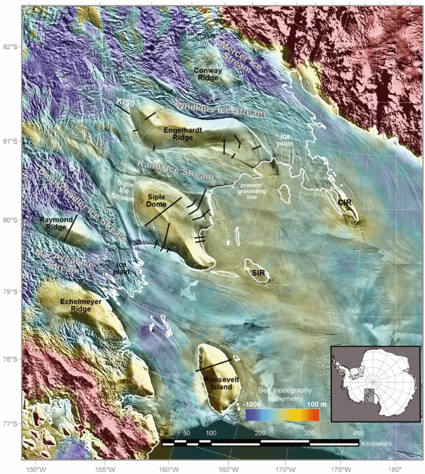
Fig. 1. MODIS Mosaic of Antarctica (MOA) over the Siple Coast ice streams (Reference Haran, Bohlander, Scambos, Painter and FahnestockHaran and others, 2006; Reference Scambos, Haran, Fahnestock, Painter and BohlanderScambos and others, 2007) with bed topography/bathymetry relative to mean sea level from Reference Le Brocq, Payne and VieliLeBrocq and others (2010). The modern grounding line position (white line) is provided by Reference Bohlander and ScambosBohlander and Scambos (2007). Ice rises and inter-ice-stream ridges are labeled in black, with Steershead and Crary Ice Rises as SIR and CIR respectively. Radar data collected by prior studies but used in our chronology are indicated with black lines. Insert shows the region in context of Antarctica.
It is important to quantify the timescales required for such changes in mass balance to occur and the impact of seemingly isolated changes in ice-stream configuration on the ice-stream system as a whole. In this paper, we synthesize previously published observations on the timing and magnitude of changes in ice-stream boundaries for the Siple Coast system in order to build a chronology of ice flow changes that span the last millennium. This chronology provides an improved understanding of the temporal and spatial scales involved in the observed variability for the region. In particular, we focus on KIS and WIS where many observations have been made and where the largest changes are observed.
Background: Siple Coast Ice Streams
Retreat of the WAIS since the LGM has been rapid in regions drained by ice streams (Reference BindschadlerBindschadler, 1998) which effectively evacuate ice from the ice-sheet interior. The Siple Coast ice-stream system consists of six fast-flowing ice streams which comprise the primary pathways for drainage of ice from the interior to the Ross Ice Shelf (Fig. 1). The ice streams have low surface slopes and, as a result, low driving stresses even though horizontal velocities of up to ~800ma-1 are reached (Reference BentleyBentley, 1987). High flow speeds within these ice streams are maintained because their basal temperatures are at the pressure-melting point (Reference EngelhardtEngelhardt, 2004) and the subglacial material is water-saturated clay (Reference Anandakrishnan, Blankenship, Alley and StoffaAnandakrishnan and others, 1998; Reference BellBell and others, 1998). As a result, basal motion occurs through a combination of basal sliding and till deformation along the ice/bed interface (Reference Blankenship, Bentley, Rooney and AlleyBlankenship and others, 1986; Reference Engelhardt, Humphrey, Kamb and FahnestockEngelhardt and others, 1990). The beds of ice streams are at slightly lower elevations than adjacent inter-ice-stream ridges under which basal freezing conditions prevail (Reference Lythe and VaughanLythe and others, 2001; Reference EngelhardtEngelhardt, 2004).
The WAIS evolved to its present form from a more horizontally extensive ice sheet that existed during the LGM (Reference BindschadlerBindschadler and Vornberger, 1998; Reference Anderson, Shipp, Lowe, Wellner and MosolaAnderson and others, 2002;Reference StoneStone and others, 2003);however, the Siple Coast ice streams likely maintained their thin, long, low-slope profiles (Reference Ackert, Mukhopadhyay, Parizek and BornsAckert and others, 2007;Reference Price, Conway and WaddingtonPrice and others, 2007) and remained approximately in their present locations (Reference Anderson, Wellner, Lowe, Mosola and ShippAnderson and others, 2001). Reference Conway, Hall, Denton, Gades and WaddingtonConway and others (1999) suggest that grounding line retreat since the end of the LGM occurred as a 'swinging gate', hinged near Roosevelt Island. According to their model, ungrounded conditions initiated at Roosevelt Island around 3kaBP. Multiple grounding zone sediment wedges within the paleo-ice-stream troughs on the floor of the Ross Sea confirm that grounding line retreat was non-steady and non-uniform across the region (Reference Anderson, Shipp, Lowe, Wellner and MosolaAnderson and others, 2002; Reference Mosola and AndersonMosola and Anderson, 2006). This picture aligns well with observations that suggest that modern ice- stream behavior is characterized by constant adjustment of discharge pathways. For example, KIS abruptly stopped ~165 years ago (Reference Retzlaff and BentleyRetzlaff and Bentley, 1993), WIS and MacAyeal Ice Stream (MacIS; former Ice Stream E) have undergone stagnation and reactivation cycles (Reference Hulbe and FahnestockHulbe and Fahnestock, 2007) and the boundaries of ice streams (both lateral margins and grounding lines) are shifting through time (e.g. Reference Clarke, Liu, Lord and BentleyClarke and others, 2000; Reference Stearns, Jezek and Van der VeenStearns and others, 2005; Reference Catania, Conway, Raymond and ScambosCatania and others, 2006 Reference Catania, Scambos, Conway and Raymondb, Reference Catania, Hulbe and Conway2010).
The tributaries of the Siple Coast ice streams reach far into the interior of the ice sheet (Reference JoughinJoughin and others, 1999) and feed ice toward their trunk regions where, in some cases, an ice plain forms. Ice plains are regions where an ice stream transitions from fully grounded to fully floating conditions over many tens of kilometers through a gradual reduction in basal drag along the flow direction (Reference Alley, Blankenship, Rooney and BentleyAlley and others, 1989). Two modern ice plains exist in the Siple Coast system. A small one exists on MacIS (Reference Anandakrishnan, Voigt, Alley and KingAnandakrishnan and others, 2003) and a much larger one occupies the combined outflow region of WIS and Mercer Ice Stream (MIS; former Ice Stream A) (Fig. 1 ; Reference Bindschadler and Vornberger Pand GrayBindschadler and others, 2005;Reference Brunt, Fricker, Padman, Scambos and O'NeelBrunt and others, 2010). Ice motion on the WIS/MIS ice plain is characterized by stick—slip behavior as a result of resistance from the subglacial till, paced by tidal forcing (Reference Anandakrishnan and AlleyAnandakrishnan and Alley, 1997;Reference Bindschadler, King, Alley, Anandakrishnan and PadmanBindschadler and others, 2003) and may be an attribute that emerges as ice streams decelerate (Reference Sergienko, MacAyeal and BindschadlerSergienko and others, 2009). The trunk region of WIS is slowing by nearly 4 m a-1 (Reference JoughinJoughin and others, 2005) and thickening by 0.06 ± 0.02 m a-1 (Reference Smith, Bentley and RaymondSmith and others, 2005). If this trend continues, WIS will stagnate by the next century (Reference JoughinJoughin and others, 2005). An ice plain is thought to have once existed in the mouth of KIS in the past (Reference Joughin and TulaczykJoughin and others, 2002; Reference Hulbe and FahnestockHulbe and Fahnestock, 2004; Reference Catania, Conway, Raymond and ScambosCatania and others, 2006a), but its extent and history have not been well constrained.
Ice streams thin along their lengths, causing a steepening of the basal temperature gradient along the flow direction, a process that can lead to freezing of basal water and a concurrent increase in basal resistance followed by slowdown and thickening (Reference Christoffersen and TulaczykChristoffersen and Tulaczyk, 2003; Reference Hulbe and FahnestockHulbe and Fahnestock, 2004). Local reduction of basal lubrication can produce variability in the ice-stream system (Reference Tulaczyk, Kamb and EngelhardtTulaczyk and others, 2000). Currently, the tendency toward freezing in the trunk regions of the Siple Coast ice streams is offset by a supply of water produced in the onset regions which provides sufficient latent heat to maintain thawed conditions at the base of the ice streams (Reference Joughin, Tulaczyk and EngelhardtJoughin and others, 2003; Reference Parizek, Alley and HulbeParizek and others, 2003; Reference Hulbe and FahnestockHulbe and Fahnestock, 2004). The amount of meltwater production suggests that they will continue to thin, resulting in continued grounding line retreat for the foreseeable future (Reference Parizek, Alley and HulbeParizek and others, 2003).
Review Of Previous Observations
We present a review of previously published observations of past configurations of the Siple Coast ice streams for the last 1000 years. Where dates are given in previously published work, we correct for the time since data acquisition (if available) or the time since publication (Table 1) in order to present a consistent time frame for all presented data. This gives dates in terms of time elapsed since year ad 1. While we present a chronology of events at specific dates (to the year) for ice flow changes, we do not infer that our timing of events is this precise. The dates are merely meant to serve as time markers that allow us to construct the chronology (Figs 2 and 3).
Table 1. Previously published observations of ice-stream variability used in our chronology. Events are grouped into time periods identified in the text corresponding to Figures 2 and 3. For each event we give the time of the event in years BP, accounting for time passed since original publication and the approximate year that the event occurred


Fig. 2. Changes in the Siple Coast ice streams from (a) AD 1000 to (b) AD 1150 to (c) AD 1450 to (d) AD 1550. Fast-moving ice is colored dark gray, slow-moving ice is white and floating ice is overlaid with dots. Lines denote ice-dynamic boundaries, shear margins and grounding lines; known position is given as a solid line, and unknown is dotted. Active boundaries are plotted with thick lines, and inactive boundaries marking the presence of a modern-day surface scar are shown as thin lines. Arrows indicate flow direction and migration direction of margins.

Fig. 3. Same as Figure 2, but from (a) AD 1650 to (b) AD 1750 to (c) AD 1850 to (d) present day.
Satellite imagery
The first visible-band satellite images (Advanced Very High Resolution Radiometer (AVHRR), Syst?me Pour l’Observation de la Terre (SPOT) and Landsat) of the Ross ice streams revealed complex surface lineations consisting of flow stripes, active and paleo-shear margins and the slope break associated with grounding lines and relict flow boundaries (Reference Scambos and BindschadlerScambos and Bindschadler, 1991). Lateral flow boundaries to ice streams (shear margins) can be identified in satellite images by the presence of crevasses. Paleo-shear margins (shear margins buried by years of accumulated snow) remain visible in satellite images (e.g Moderate Resolution Imaging Spectroradiometer (MODIS)) (Fig. 1 ; Reference Haran, Bohlander, Scambos, Painter and FahnestockHaran and others, 2006) because of enhancement through image stacking. Paleo-shear margins are, however, difficult to identify on the ground because they typically have amplitudes of a few meters and wavelengths of several kilometers (Reference Catania, Conway, Gades, Raymond and EngelhardtCatania and others, 2003, Reference Catania, Conway, Raymond and Scambos2005).
Flow stripes occur in fast-moving regions and originate either from fast flow over bed bumps (Reference Gudmundsson, Raymond and BindschadlerGudmundsson and others, 1998) or flow extension in onset regions (Reference Glasser and GudmundssonGlasser and Gudmundsson, 2011). Comparison of the character of the surface topography within regions of rapid flow and those with slow-moving ice reveals the presence of paleo-ice streams: regions that were once flowing fast but are now stagnant. Such regions are characterized by muted flow stripes and lateral ‘scar’ features marking the presence of buried shear margins (Reference Scambos and BindschadlerScambos and Bindschadler, 1991; Reference Scambos and NeresonScambos and Nereson, 1995). Reference Jacobel and GadesJacobel and Gades (1995) and Reference Conway, Catania, Raymond, Scambos, Engelhardt and GadesConway and others (2002) used the presence of these muted surface features to identify a relict tributary to KIS and Siple Ice Stream (SIS), a distributary to KIS (Fig. 1). Paleo- shear margins of these and other stagnant ice streams, most notably KIS, mark their lateral extent (Reference Scambos and NeresonScambos and Nereson, 1995; Reference Anandakrishnan, Alley, Jacobel, Conway, Alley and BindschadlerAnandakrishnan and others, 2001).
Reference Fahnestock, Scambos, Bindschadler and KvaranFahnestock and others (2000) used flow stripes and rifts visible in AVHRR images coupled with the Ross Ice Shelf Geophysical and Glaciological Survey (RIGGS) ice-shelf velocity field (Reference Thomas, MacAyeal, Eilers and GaylordThomas and others, 1984) to determine when features visible in satellite images were formed by tracing their provenance. From this, they deduced large changes in ice-stream discharge and configuration throughout the last 1000 years, including evidence for the shutdown of KIS ~165 years ago (ad 1837), grounding of Steershead Ice Rise ~350 years ago (ad 1650) and the reduction in discharge of WIS relative to MIS ~550 years ago (ad 1450). We summarize their major findings in Table 1.
A new picture of ice-stream configuration emerged when RADARSAT mapped surface velocities in the Siple Coast sector for the first time (Reference JoughinJoughin and others, 1999). These data revealed an inland network of tributaries that connect ice streams in their upper catchment regions, even for KIS despite a stagnant trunk. In addition, the RADARSAT data have been used in conjunction with older satellite imagery (and other datasets) to discover a reduction in the speed of WIS (Reference Joughin, Tulaczyk and EngelhardtJoughin and others, 2003;Reference Stearns, Jezek and Van der VeenStearns and others, 2005) suggesting its eventual shutdown in ~ AD 2150 (Reference JoughinJoughin and others, 2005).
Satellite altimetry
Detailed mapping of surface elevation changes is accomplished using satellite altimeters. Repeat-track analysis of surface elevation data determined by NASA’s Ice, Cloud and land Elevation Satellite (ICESat) has been used to identify the position of, and changes in, the grounding line (Reference Fricker and PadmanFricker and Padman, 2006; Reference Horgan and AnandakrishnanHorgan and Anandakrishnan, 2006; Reference Brunt, Fricker, Padman, Scambos and O'NeelBrunt and others, 2010). Comparison to previous grounding line position estimates indicates that the grounding line has not migrated significantly in the last few decades (Reference Horgan and AnandakrishnanHorgan and Anandakrishnan, 2006), although rates of retreat of up to ~400ma-1 have been measured along some parts of the WIS grounding line (Reference BindschadlerBindschadler and Vornberger, 1998; Reference Fricker and ScambosFricker and Scambos, 2009;Reference Brunt, Fricker, Padman, Scambos and O'NeelBrunt and others, 2010). ICESat repeat- and cross-track analysis for ice-sheet thickness changes shows thinning throughout most of the region with the exception of the KIS tributary region and the WIS trunk, where thickening is occurring (Reference Smith, Bentley and RaymondSmith and others, 2005; Reference Pritchard, Arthern, Vaughan and EdwardsPritchard and others, 2009). These studies suggest that changes occurring in this region are ongoing.
Satellite-derived observations of localized surface elevation changes have also led to the discovery of rapidly draining and filling subglacial lakes through repeat-track observations of localized elevation changes (e.g. Reference Gray, Joughin, Tulaczyk, Spikes, Bindschadler and JezekGray and others, 2005; Reference Wingham, Siegert, Shepherd and MuirWingham and others, 2006; Reference Fricker, Scambos, Bindschadler and PadmanFricker and others, 2007; Reference Stearns, Smith and HamiltonStearns and others, 2008; Reference Fricker and ScambosFricker and Scambos, 2009). Such observations reveal that the residence times for water in these lakes can be short (months to years) and that lake systems may be connected (drainage in one lake often results in filling of another lake at a lower hydraulic potential). The impact on ice flow speed has only been observed for Byrd outlet glacier (Reference Stearns, Smith and HamiltonStearns and others, 2008) which experienced a 10% increase in speed over a 14 month time period that was well timed with the drainage of a lake into the Byrd Glacier subglacial drainage system.
Ice-penetrating radar data
While the record of ice-sheet change can be readily observed in satellite images, the timing of past changes remains uncertain without additional information. Ice- penetrating radar data make visible the internal stratigraphy of ice sheets and have been used extensively to interpret and date historical changes in ice flow dynamics (e.g. Reference Rippin, Siegert and BamberRippin and others, 2003, Reference Rippin, Siegert, Bamber, Vaughan and Corr2006). This is typically accomplished using radar data collected over paleo-ice-stream shear margins. Shear-margins are characterized by multiple crevasse-ridden zones with both chaotic and organized patterns of crevas- sing (Reference Echelmeyer, Harrison, Larsen and MitchellEchelmeyer and others, 1994). In radar, paleo-shear margin crevasses are identified as hyperbolic diffractors that occur at a burial depth related both to the accumulation rate and the timing of crevasse closure (which is assumed to be synchronous with ice-stream shutdown). The timing of the shutdown of KIS was determined to be ~165 years bp, in AD 1837 (Reference Retzlaff and BentleyRetzlaff and Bentley, 1993; Reference Catania, Conway, Raymond and ScambosCatania and others, 2006b), based on an accumulation rate of 0.058 m a-1 and a crevasse burial depth of 18 m. Additional shear margins have been dated using similar techniques (Reference Clarke, Liu, Lord and BentleyClarke and others, 2000; Reference Conway, Catania, Raymond, Scambos, Engelhardt and GadesConway and others, 2002;Reference Smith, Lord and BentleySmith and others, 2002; Reference Catania, Conway, Raymond and ScambosCatania and others, 2005, Reference Catania, Conway, Raymond and Scambos2006b). Timing estimates for ice- stream marginal changes from these studies (Fig. 1) are listed in Table 1. Typical error estimates for dating shear margins are about 10% of the age, which accounts for the change in radar-wave travel times in the firn column.
Grounding lines are identified in radar-derived stratigraphy by the presence of basal crevasses (Reference Uratsuka, Nishio and MaeUratsuka and others, 1996; Reference Catania, Hulbe and ConwayCatania and others, 2010) and in some cases by the formation of locally downwarped internal layers due to sub-ice-shelf basal melting (Reference Catania, Conway, Raymond and ScambosCatania and others, 2006 Reference Catania, Hulbe and Conwaya, 2010; Reference SmithSmith, 1996). Using the degree of layer downwarping and expected rates of basal melting, the duration of ungrounded conditions can be estimated, as has been done for several grounding line locations in our study region (Reference Catania, Hulbe and ConwayCatania and others, 2010). Their results indicate that the KIS grounding line migrated ~100km inland roughly between AD 1067 and ad 1167 and advanced toward its present location ~440 years later (ad 1567). Additional data from the north side of Siple Dome and the south side of Roosevelt Island indicate that the grounding line has been in its present location since between AD 1607 and 1807 and since AD 1607 respectively (Reference Catania, Hulbe and ConwayCatania and others, 2010). Dates from these studies are summarized in Table 1, with their radar data collection locations shown in Figure 1. Significant uncertainty exists for these grounding line ages owing to the lack of knowledge of past grounding line melt rates, so Reference Catania, Hulbe and ConwayCatania and others (2010) argue that their date estimates are maxima.
The formation and longevity of ice rises (Fig. 1) may also be used to constrain grounding line history. Three prominent ice rises exist in the Ross Ice Shelf: Roosevelt Island, Crary Ice Rise and Steershead Ice Rise. Radar-derived ice-sheet stratigraphy across Roosevelt Island indicates that the ice divide here formed ~3200 years ago (1190 BC), implying that the grounding line was upstream of this island until that time (Reference Conway, Hall, Denton, Gades and WaddingtonConway and others, 1999). We assume that at this time the grounding line was everywhere upstream of Roosevelt Island. Two deep borehole temperature records were used by Reference Bindschadler, Roberts and IkenBindschadler and others (1990) to establish that Crary Ice Rise grounded in two stages: the north side becoming grounded 600 years ago, in ad 1410, while the southern side grounded earlier, ~ 1120 years ago (ad 890). Analysis of flow stripes and crevasse patterns around Steershead Ice Rise suggests that it grounded more recently, in ad 1650 (Reference Fahnestock, Scambos, Bindschadler and KvaranFahnestock and others, 2000). These results are summarized in Table 1.
Ice-penetrating radar data have also been used to interpret long-term regional changes in mass balance through examination of ice-sheet divide migration of inter- ice-stream ridges. Reference Nereson, Raymond, Waddington and JacobelNereson and others (1998) found that the position of an ice-sheet divide straddled by ice streams will be sensitive to the discharge through those ice streams and the spatial distribution of accumulation. Discounting changes in accumulation as a driver of divide migration, Reference Nereson and RaymondNereson and Raymond (2001) examined inter-ice-stream ridges throughout the Siple Coast region and found that all of the ice divides there showed northward migration, suggesting progressively higher rates of thinning across the Siple Coast region from MacIS toward WIS, with the most thinning occurring in the last 1000 years at WIS. This is in agreement with modern rates of enhanced thinning from ICESat on WIS (Reference Pritchard, Arthern, Vaughan and EdwardsPritchard and others, 2009).
Ice flow models
Ice-sheet models have been used to explore ice-sheet variability in the Siple Coast region. Ice-stream discharge variability results, in part, because of the existence of closely spaced bedrock troughs that direct ice flow and force competition for ice between adjacent ice streams (Reference Payne and DongelmansPayne and Dongelmans, 1997; Reference PaynePayne, 1998). Variability also arises because ice streams run just on the verge of shutting down all of the time (Reference Hulbe and FahnestockHulbe and Fahnestock, 2004). This is because ice-stream discharge is thermally regulated, and involves basal meltwater interaction with subglacial till (Reference MacAyealMacAyeal, 1992; Reference PaynePayne, 1998; Reference Tulaczyk, Kamb and EngelhardtTulaczyk and others, 2000; Reference Bougamont, Tulaczyk and JoughinBougamont and others, 2003). Using observational data of past flow variations to constrain and validate their numerical ice flow model, Reference Hulbe and FahnestockHulbe and Fahnestock (2004, Reference Hulbe and Fahnestock2007) were able to reproduce the distorted streak lines preserved on the Ross Ice Shelf (Fig. 1) by forcing changes in ice-stream mass flux and ice-rise formation to find the best match to the observed streak-line patterns. Their solution was found when WIS and MacIS experienced periods of prolonged stagnation, and we use their estimates for the timing of ice-stream shutdown and reactivation for these ice streams in Table 1. In addition, because the grounding line in the model studies of Reference Hulbe and FahnestockHulbe and Fahnestock (2007) was determined by flotation, changes in ice thickness during their observational period will drive changes in the position of the grounding line and allow a rough history of grounding line position to be determined (Figs 2 and 3).
Results: Ice-Flow Chronology
We use the observations described above to assemble a chronology of events (Table 1) that have occurred in the Siple Coast region over the last 1000 years. This chronology allows us to depict the most significant changes that have occurred in this region over that time period (Figs 2 and 3). We have grouped observations into time periods that break up the major reorganizational events occurring in the region. This results in time periods (described below) of differing length. Since we only have limited information about the position of ice-stream margins and grounding lines at very specific times and locations, we must infer their positions over time between known locations. In general, we use the grounding line position from Reference Hulbe and FahnestockHulbe and Fahnestock (2007) who determine its position from flotation. Although we do not have information on elevation changes over the region until quite recently, we augment known grounding line position with inferred grounding line position based on expected thickness changes resulting from changes in ice flow through time. For example, during WIS stagnation between ad 1150 and 1557, we infer that ice streams on either side expanded laterally into the region from which WIS flowed. This expansion would allow for thinning of ice in these adjacent ice streams and possible grounding line retreat. The inferred grounding line position is shown as the dotted grounding line in Figures 2 and 3. More certain grounding line position information is provided by radar data and is shown by the solid grounding line in Figures 2 and 3.
Similar to the grounding line, we have only limited information about the position of ice-stream shear margins in the past. We assume that margin migration could occur in jumps, following Reference Retzlaff and BentleyRetzlaff and Bentley (1993) and Catania and others (2006b). We further assume that the shape of paleo-shear margins in plan form represents their shape and lateral extent when the ice streams were once active. This allows us to depict changes in the positions of shear margins in Figures 2 and 3. Uncertainty in dates from ice-penetrating radar data is 10% of the estimated age. No uncertainty estimates are given for dates provided in model or satellite studies, so we are not able to provide those here.
Period 1: AD 1000-1207
For convenience, we assume that all of the major ice streams were fast-moving at the beginning of this time period. We also assume that distributary SIS and tributary KIS0 were active and that KIS was at its widest extent (Fig. 2a). We approximate the grounding line position using the model results from Reference Hulbe and FahnestockHulbe and Fahnestock (2007) and evidence that the southern edge of Crary Ice Rise grounded in ad 890 (Fig. 2a; Reference Bindschadler, Roberts and IkenBindschadler and others, 1990). Both WIS and MacIS stagnated within ~50 years of each other near AD 1150, marking the end of this period (Fig. 2b; Reference Hulbe and FahnestockHulbe and Fahnestock, 2007).
Period 2: AD 1207-1557
The shutdown of WIS had a dramatic impact on KIS and MIS. KIS experienced ~100km regression of its grounding line (Fig. 2b) occurring either coincident with or just after WIS stagnation (Reference Catania, Hulbe and ConwayCatania and others, 2010). Grounding line retreat over such a short period must be a consequence of thinning, likely a result of lateral spreading across the confluence region of KIS, WIS and MIS due to the shutdown, and thus reduced outflow, of WIS. In addition to the observed grounding line retreat of KIS, we also expect grounding line retreat across the MIS/WIS ice plain after WIS shutdown (Reference Hulbe and FahnestockHulbe and Fahnestock, 2007).
During this time period, Crary Ice Rise expanded to the northeast (Reference Bindschadler, Roberts and IkenBindschadler and others, 1990), possibly as a result of local changes in basal water supply due to the initial freeze-on of its southern side (Fig. 2c). The growth of Crary Ice Rise may have further delayed the reactivation of WIS by continuing to block its outflow. Streaming flow from MIS continued to push the stagnant WIS ice around the northeastern side of Crary Ice Rise, producing a large distortion in the streak lines, which are still visible on the Ross Ice Shelf (Reference Fahnestock, Scambos, Bindschadler and KvaranFahnestock and others, 2000; Reference Hulbe and FahnestockHulbe and Fahnestock, 2007). The reactivation of WIS in AD 1557 marks the end of this period (MacIS, which shut down in AD 1207, reactivated in AD1357 (Reference Hulbe and FahnestockHulbe and Fahnestock, 2007)).
Period 3: AD 1557-1837
With the reactivation of WIS, outflow from KIS became laterally constrained causing thickening, which was likely responsible for the rapid, widespread grounding line advance that occurred throughout the KIS trunk at this time. Reference Catania, Hulbe and ConwayCatania and others (2010) dated the seaward migration of the KIS grounding line at AD 1567, just 10 years after the WIS reactivation (Fig. 2d). With uncertainty in age estimates, these events may be viewed as synchronous. Retreat of the southern edge of Roosevelt Island grounding line to its modern position occurred in AD 1607 (Reference Catania, Hulbe and ConwayCatania and others, 2010), roughly 400 years after the stagnation of MacIS. The southern grounding line of Roosevelt Island is currently downstream of the northern shear margin of MacIS and we estimate that it would have taken ~400 years for the effects of the MacIS stagnation (which would have led to localized thinning) to reach Roosevelt Island where it would have caused grounding line retreat (assuming an average ice- stream speed of ~500 m a-1).
The KIS distributary, SIS, shut down in AD 1582 (personal communication from B., Smith, 2010) after grounding line readvance of KIS (Fig. 2d). Shortly after the SIS shutdown, the grounding line along the northern edge of Siple Dome retreated to its modern location (Reference Catania, Hulbe and ConwayCatania and others, 2010), consistent with the idea that thinning occurs in regions adjacent to locations of ice-stream shutdown (Reference Hulbe and FahnestockHulbe and Fahnestock, 2007).
The northern KIS shear margin position jumped inward in AD 1652, 100 years after the KIS grounding line readvance (Reference Catania, Conway, Raymond and ScambosCatania and others, 2006b). This event isolated a triangularshaped region of ice adjacent to Siple Dome often called the ‘Duckfoot’ (Fig. 3a). Because the southern margin of KIS has been stable in its present location for several hundred years (as evidenced by a continuous streak line on the Ross Ice Shelf; Reference Fahnestock, Scambos, Bindschadler and KvaranFahnestock and others, 2000), Reference Catania, Conway, Raymond and ScambosCatania and others (2006b) conclude that inward migration of the northern margin led to narrowing and a subsequent reduction in KIS discharge. Steershead Ice Rise formed coincident with KIS narrowing (Reference Fahnestock, Scambos, Bindschadler and KvaranFahnestock and others, 2000). Ice-rise formation may have caused a regional reorganization of flow that, in turn, drove the migration of the northern KIS margin. These changes in the trunk region of KIS were quickly followed by the shutdown of tributary KIS0 in AD 1750 (Fig. 3b) (Reference Conway, Catania, Raymond, Scambos, Engelhardt and GadesConway and others, 2002).
Period 4: AD 1837 to present
The entire downstream trunk of KIS stagnated rapidly in AD 1837 (Reference Retzlaff and BentleyRetzlaff and Bentley, 1993), coincident with a minor inward shift of the WIS northern margin (Fig. 3c; Reference Fahnestock, Scambos, Bindschadler and KvaranFahnestock and others, 2000; Reference Catania, Conway, Gades, Raymond and EngelhardtCatania and others, 2003) and inward migration of the southernmost WIS tributary (Reference Clarke, Liu, Lord and BentleyClarke and others, 2000). With the stagnation of KIS, the supply of ice to the ice shelf is reduced and grounding line retreat near KIS is inevitable. At the time of the RIGGS surveys, the northernmost portion of the KIS grounding line was retreating at a rate of 30 m a-1 (Reference Thomas, Stephenson, Bindschadler, Shabtaie and BentleyThomas and others, 1988). Modern grounding line retreat rates for most of this region are currently very small (Reference Horgan and AnandakrishnanHorgan and Anandakrishnan, 2006), suggesting that the grounding line might retreat in jumps as observed in the past. This idea is supported by the presence of grounding zone sediment wedges on the Siple Coast floor which indicate that grounding line retreat was sporadic (Reference Mosola and AndersonMosola and Anderson, 2006; Reference Dowdeswell, Ottesen, Evans, OCofaigh and AndersonDowdeswell and others, 2008).
Active tributaries continue to feed into the upstream end of the stagnant KIS trunk, causing thickening in the transition region between active and stagnant flow regimes (near the junction between the KIS0 tributary and the KIS trunk; Fig. 1). Thickening occurs at a maximum rate of 0.5 m a-1 but extends upstream into the tributaries at rates of 0.260.29 ± 0.03 m a-1 (Reference Smith, Bentley and RaymondSmith and others, 2005) and has resulted in diversion of flow toward the upper regions of adjacent WIS and Bindschadler Ice Stream (BIS; formerly Ice Stream D) (Reference Price, Bindschadler, Hulbe and JoughinPrice and others, 2001). At the junction between the bulge and the stagnant trunk of KIS, driving stress and the hydraulic gradient must both be increasing over time as the bulge area thickens and the surface slope at the junction increases (Reference Price, Bindschadler, Hulbe and JoughinPrice and others, 2001).
At present, WIS is slowing at a rate that is expected to cause complete stagnation in 70-80 years (Reference Joughin and TulaczykJoughin and others, 2002; Reference Stearns, Jezek and Van der VeenStearns and others, 2005). From 1942 to 1998 the WIS ice plain was thinning (Reference Bindschadler and Vornberger Pand GrayBindschadler and others, 2005), but more recent observations from 2003 to 2005 show that it is now thickening (Reference Smith, Bentley and RaymondSmith and others, 2005; Reference Pritchard, Arthern, Vaughan and EdwardsPritchard and others, 2009). In addition to slowing and thickening, WIS is exhibiting modulated outflow according to the tidal cycle (Reference Bindschadler, King, Alley, Anandakrishnan and PadmanBindschadler and others, 2003). These observations may signal that WIS has already begun to make way for KIS reactivation; thickening and stick-slip behavior likely result from increased basal resistance (Reference Sergienko, MacAyeal and BindschadlerSergienko and others, 2009). This is consistent within our framework of ice-stream cyclicity and the bimodal behavior of WIS and KIS (Reference PaynePayne, 1998).
Discussion
Theoretical switches between fast and slow ice-stream motion have been reproduced in numerical ice-sheet models (Reference MacAyealMacAyeal, 1992; Reference Payne and DongelmansPayne and Dongelmans, 1997; Reference PaynePayne, 1998;Reference Tulaczyk, Kamb and EngelhardtTulaczyk and others, 2000; Reference Bougamont, Tulaczyk and JoughinBougamont and others, 2003;Reference Hulbe and FahnestockHulbe and Fahnestock, 2007) and are supported in our chronology. Proposed mechanisms for such switches involve thermodynamics at the ice-till interface, competition for ice in the upstream catchment, and interaction across the ice plain at the downstream ends of ice streams. Reference Hulbe and FahnestockHulbe and Fahnestock (2004) identified ice- stream discharge cycles related to thermal instabilities that consist of an initial stage of fast thinning through the trunks of ice streams, promoting basal freeze-on and stoppage. Our chronology supports the thermal regulation hypothesis as there are no definitive events that occur prior to ice-stream shutdown that might cause shutdown to occur. One exception to this is KIS, which narrowed prior to shutdown. Narrowing causes a reduction in velocity that could exacerbate the loss of lubrication through a further reduction in basal shear heating (Reference Catania, Conway, Raymond and ScambosCatania and others, 2006b). Downstream of the grounding line, there is an infinite water supply; however, thinning can cause local bed obstructions to emerge as ice rises that, in turn, cause redirections of ice- stream flow that imprint on the streak-line record. We observe that the formation of ice rises precedes or is coincident with changes in ice-stream width (Figs 2 and 3).
Our chronology does not demonstrate a great amount of connectivity across ice streams in their catchment regions, although we have limited observations in those regions. We do observe a large amount of ice-stream interaction across their downstream reaches. In particular, changes in WIS and KIS appear to be intimately linked. Regions without large ice plains (e.g. MacIS and Echelmeyer Ice Stream (former Ice Stream F)) and where ice flow is typically bedrock- controlled (e.g. Ronne-Filchner ice streams) do not show as much flow variability as WIS and KIS. This suggests that the particular bed topography of this region may permit ice plains to exist. Bathymetric data below the Ross Ice Shelf are sparse but indicate shallowing downstream of the modern grounding line around Siple Dome, KIS and WIS (Fig. 1). Any ice plain that developed in the mouth of KIS, as well as the modern WIS ice plain, would be characterized by flat surface topography. Local transients in ice thickness and surface slope on the ice plains might propagate laterally across them, allowing for the observed interaction between WIS and KIS.
In addition to total shutdown, we find that numerous changes in ice-stream configuration (shear margin and grounding line migration) also influence discharge over decadal to century timescales. Our reconstruction indicates that changes in discharge typically occur quickly. For example, the narrowing of KIS occurred in ~10 years (Reference Catania, Conway, Raymond and ScambosCatania and others, 2006b). Such rapid changes in margin position are due to rapid changes in the amount or distribution of basal lubrication, likely a result of basal freeze-on. It may also be possible that rapid changes in margin position could occur in conjunction with changes in the flux of water through the drainage/filling of subglacial lakes. The acceleration of Byrd Glacier due to upstream subglacial lake drainage might be expected, given that it is confined within the boundaries of the Transantarctic Mountains. The ice streams throughout Siple Coast also have many subglacial lakes beneath them (Reference Gray, Joughin, Tulaczyk, Spikes, Bindschadler and JezekGray and others, 2005; Reference Fricker, Scambos, Bindschadler and PadmanFricker and others, 2007; Reference Fricker and ScambosFricker and Scambos, 2009), but because the lateral boundaries of these ice streams are not as topographically controlled, the movement of subglacial water may alter the distribution of basal lubrication, thus promoting jumps in margin position, rather than gradual migration. This would be especially true for those lakes situated close to the active shear margins (on WIS, this is the case for most of the observed subglacial lakes), but recent observations indicate that significant meltwater is generated within the ice-stream shear margins (Reference Beem, Jezek and Van der VeenBeem and others, 2010).
We also observe fluctuations in the position of the grounding line at a time period when regionally steady grounding line retreat is expected (e.g. Reference Conway, Hall, Denton, Gades and WaddingtonConway and others, 1999). To some degree we may gain insight into grounding line variability by examining shoreline variability within experimental fluvial-deltaic systems where timescales for change are much shorter. In such systems the shoreline position is dictated by a combination of externally forced parameters, like sea level, and internal variability in the sediment supply from the channel system (Reference Kim, Paola, Swenson and VollerKim and others, 2006). In flume experiments Reference Kim, Paola, Swenson and VollerKim and others (2006) found greater rates of variability in the shoreline position during periods of forced shoreline retreat. This occurs because the shoreline is migrating against the sediment transport regime. An analogy may be made to ice-sheet grounding lines where, over short timescales, ice supply (influencing thickness) dictates the position of the grounding line; a steady supply of thick ice emerging from the ice streams acts against imposed grounding line retreat. We suggest that the observed variability in discharge may be typical during the retreat phase of the ice sheet. Further confirmation of this is the presence of sediment wedges that form along some portions of the grounding line (Reference Anandakrishnan, Catania, Alley and HorganAnandakrishnan and others, 2007) that may act to temporarily stabilize parts of the grounding line against retreat (Reference Alley, Anandakrishnan, Dupont, Parizek and PollardAlley and others, 2007). The presence of several grounding zone wedges within the paleo-ice-stream troughs confirms that during periods of sea- level rise, grounding line retreat is not steady (Reference Mosola and AndersonMosola and Anderson, 2006). Our reconstruction confirms that grounding line retreat, at least for KIS, is episodic and punctuated by periods of advance.
Conclusions
The Siple Coast ice streams have undergone changes in configuration and discharge that are documented in many previous studies. We compile the observations from these past studies to assemble a chronology of ice-stream reorganizational events (Table 1; Figs. 2 and 3). Our reconstruction of ice flow history confirms that discharge cycles are typical for ice streams in this region. These discharge changes occur as a result of changes in ice-stream margin and grounding line positions as well as complete ice- stream shutdown, which is observed for three of the ice streams in this region over our 1000year history. In part, flow variability here occurs because of the high degree of interaction between adjacent ice streams in their trunk/ice- plain regions (likely because of shallow bed topography) but also because of changes in the distribution and supply of basal meltwater (either due to changes in subglacial lakes or because of basal freeze-on), causing local reductions in traction which can lead to shutdown. Downstream of the grounding line, thinning causes ice rises to emerge which locally block or redirect ice-stream outflow. Our observations provide a validation dataset for further modeling of ice flow in this region.
The WIS/KIS region has long been the focus of ice-stream variability studies and previous work focused on the apparently unique shutdown of KIS. Our reconstruction indicates that other ice streams (and their tributaries and distributaries) also experience stagnation, reactivation and margin migration. Further, ice-stream shutdown cannot be examined as an isolated event. We suggest that shutdown of individual ice streams should be expected in a system where small-scale, short-term variability is common despite the stability of the overall channel network pattern (and discharge), similar to fluvial systems. Ice-stream shutdown can have a pronounced effect on the short-term mass balance for this part of Antarctica (Reference Joughin and TulaczykJoughin and Tulaczyk, 2002) and we advocate that future estimates of mass balance take into account the timescales for change in this region: discharge changes occur on approximately decadal to century timescales which are similar to timescales for mass-balance projections. As a whole, the Siple Coast ice- stream system is adjusting to changes in both external (climate-driven) and internal (thermodynamic-driven) forces. As a result, predictions of mass balance that only take into account the effects of one or two ice streams, or those that calculate mass balance over a short time period may mislead future estimates. In order to understand how mass balance might change in the future, thermomechanical ice flow models must begin to incorporate the possibility of rapid ice- stream stagnation and the unique physics represented by ice plains and grounding lines. Predictive models of Antarctic mass balance will not be robust until we can further characterize the short term variability within this complex ice-stream system.
Acknowledgements
Imagery for this work was provided through the Antarctic Glaciological Data Center at the US National Snow and Ice Data Center. This work was supported by the US National Science Foundation (grants 0PP-0538120 to Catania, OPP- 9909518 to Raymond and OPP-0296099 to Hulbe). We appreciate the helpful comments from two anonymous reviewers and our scientific editor, Helen Fricker, which greatly improved the manuscript.


