


Introduction
Ice cores provide crucial and often unique records of climate variability for regions with sparse observations and for the pre-instrumental period. The thicknesses of individual annual layers and the annual averages of the oxygen isotopic ratio (δ18O) originating from the precipitation preserved in glaciers and ice sheets provide essential proxy records of annual net accumulation and temperature, respectively. However, these annually resolved records may contain seasonal biases reflecting the distribution of precipitation throughout the year. For example, if a drill site receives considerably more summer than winter precipitation then the annually averaged δ18O value and the net annual accumulation may be more representative of summer conditions. Hence, knowledge of potential seasonal biases is essential for accurate interpretation and utilization of the proxy records.
Ice-core-derived paleo-proxy data are commonly used to study the past behavior of large-scale circulations and teleconnection patterns such as the North Atlantic Oscillation (NAO). The NAO signal is best preserved in ice-core-derived accumulation records from west central Greenland (Reference Appenzeller, Schwander, Sommer and StockerAppenzeller and others, 1998; Reference Mosley-Thompson, Readinger, Craigmile, Thompson and CalderMosley-Thompson and others, 2005; Reference Calder, Craigmile and Mosley-ThompsonCalder and others, 2008). The NAO is a dominant wintertime phenomenon that heavily influences the position and intensity of the North Atlantic storm track. Winter precipitation over the Greenland ice sheet (GrIS) is governed by cyclones associated with this storm track, while summer synoptic patterns include generally weaker cyclones over Baffin Bay to the west (Reference Schuenemann, Cassano and FinnisSchuenemann and others, 2009). Reference Merz, Raible, Fischer, Varma, Prange and StockerMerz and others (2013) found that annual synoptic fields governing accumulation in west central Greenland resemble the winter fields, suggesting that winter variability is likely captured in the annual signal. However, they also noted that the seasonal variability captured depends strongly on the seasonal contribution of accumulation, which varies under different climate states. This study focuses on the seasonal distribution of accumulation, but seasonal variability is also important when examining annually resolved proxy data, especially for regions where one season tends to dominate the annual variability.
Previous modeling and reanalysis studies suggest that the large sub-region of west central Greenland typically receives more precipitation in summer than in winter (Reference Chen, Bromwich and BaiChen and others, 1997; Reference Bromwich, Chen, Li and CullatherBromwich and others, 1999). These studies are supported by sparse observations from meteorological stations in Greenland located primarily along the coast, where steep and complex topographical gradients strongly influence the spatial patterns of precipitation. Precipitation gauges at these stations have difficulty distinguishing between solid and liquid precipitation and also suffer from severe under-catchment issues, especially in windy conditions, which are more prevalent in winter. Although adjustments are made to overcome some of these difficulties (Reference AðalgeirsdóttirAðalgeirsdóttir and others, 2009), the precipitation data may not fully represent the actual precipitation along the coast and are even less likely to represent precipitation further inland over the ice sheet. Moreover, reanalysis datasets assimilate these station data into models and interpolate them over Greenland to a coarse resolution grid, which may not be able to capture the spatially complex precipitation dynamics. Thus, the summer precipitation maximum reported by previous studies for the entirety of west central Greenland may primarily reflect coastal trends.
Given the recent reconstruction of a 241 year annually resolved proxy history from the 2007 Crawford Point (CP) ice core in west central Greenland (Reference PorterPorter, 2013), it is crucial to examine the seasonal distribution of precipitation and accumulation in the vicinity of the drill site. Fortunately, sub-hourly surface height data from a nearby (within 3 km) automatic weather station (AWS), installed in May 1995, make this assessment possible. The in situ ice-core-derived accumulation and AWS surface height measurements are compared with precipitation from four coastal stations and with accumulation at the CP site derived from five reanalysis datasets and a regional model at the CP site. Based upon the agreement between the reanalyzed and modeled accumulation and the AWS observations, the simulated data extend the analysis of accumulation seasonality prior to installation of the AWS.
Data And Methods
In 2007 a long (152 m) multi-century ice core was drilled at CP (69.90° N, 47.00° W; ~2000 m a.s.l.) as part of a Center for Remote Sensing of Ice Sheets (CReSIS) field campaign (Fig. 1). CP is located in the upstream region of the Jakobshavn Isbræ drainage basin. The CP core was dated back to AD 1766 using well-preserved seasonal variations in both δ18O and the concentration of insoluble dust particles. Oxygen isotopic fractionation depends on temperature, so δ18O serves as a proxy for temperature where minima represent winter and maxima represent summer. Annual layers are delineated by δ18O minima, winter to winter, which approximately represent a calendar year (Fig. 2a), and the thickness between δ18O minima represents the net annual accumulation (A n). To account for the thinning of annual layers with depth due to snow and firn compaction and densification, the annual layer thicknesses were converted to water equivalent (w.e.) using a density model constructed from densities measured on the core as it was drilled (Fig. 2b). No adjustments were made for thinning due to ice flow, given the short length of the core (152 m) relative to the total ice thickness (~2000 m). Thus, the CP ice core yields an annually resolved record of net accumulation (A n). Extraction of robust sub-annual accumulation information from the CP ice core is not possible. However, the AWS observations and simulated accumulation provide an opportunity to investigate sub-annual timescales to determine whether a seasonal bias is present.

Fig. 1. Map of Greenland showing locations of the CP ice core (star), multi-century cores drilled by previous Program for Arctic Regional Climate Assessment (PARCA)/CReSiS projects (inverted triangles) and meteorological stations measuring precipitation (circles). Numbers refer to stations: 1. Aasiaat; 2. Ilulissat; 3. Sisimiut; 4. Kangerlussuaq.
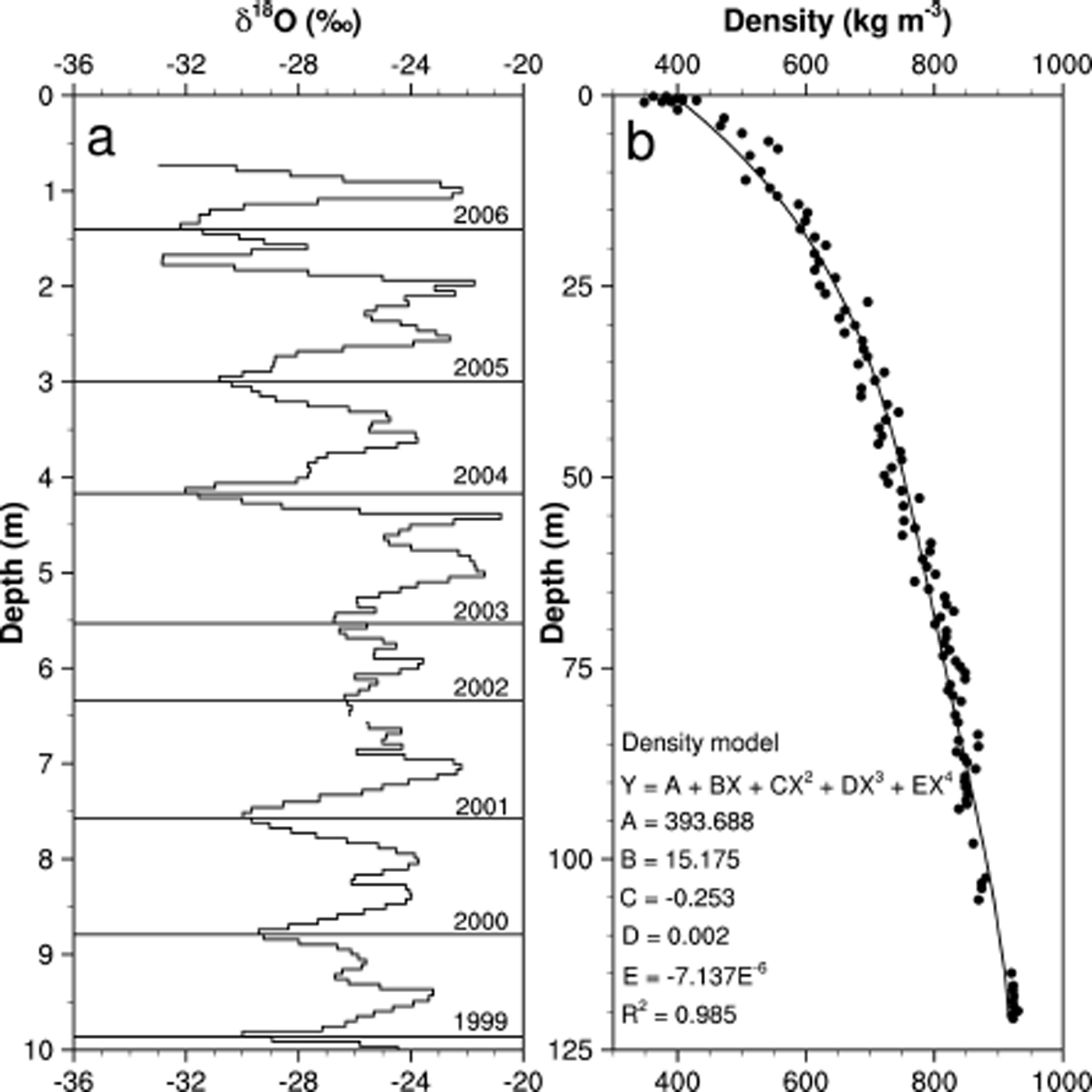
Fig. 2. (a) δ18O measurements for each sample in a 10 m section of the CP ice core illustrating delineation of years and determination of annual layer thicknesses. (b) Density measurements (circles) and model (line) for the core.
NASA’s Program for Arctic Regional Climate Assessment (PARCA) was developed to understand climatological and glaciological changes in the surface mass balance of the GrIS by employing remote-sensing technologies and a comprehensive network of AWSs and ice cores (Reference Mosley-ThompsonMosley-Thompson and others, 2001; Reference Steffen and BoxSteffen and Box, 2001; Reference Thomas and PARCAThomas and PARCA, 2001). During the PARCA campaign, an AWS was installed at CP (69.88° N, 46.99° W) in May 1995 and has recorded sub-hourly measurements of air and snow temperature, wind speed and direction, relative humidity, pressure, shortwave radiation and changes in snow height. Acoustic depth gauges measure the surface height changes that result from a combination of precipitation, post-depositional drift, sublimation/melt and compaction (Reference Steffen, Box and AbdalatiSteffen and others, 1996). Data from the CP AWS span May 1995 to the present, with some discontinuities due to intermittent equipment failures.
Precipitation data were gathered from four meteorological stations in west central Greenland. Three of these stations are located in complex topography along the coast, while Kangerlussuaq is situated in a more protected embayment slightly further inland (Fig. 1). Complete annual precipitation data begin for most of the stations at about 1960, with the exception of Ilulissat, which extends back to 1874. For these stations, greater precipitation occurs in summer and autumn and minimum precipitation in spring. For Aasiaat and Sisimiut, precipitation exhibits an increasing trend for all seasons, especially in the most recent decade (Reference MernildMernild and others, 2014). The precipitation data from the three coastal stations do not agree with the inland CP A n (Fig. 3); however, Kangerlussuaq precipitation agrees well despite its greater distance from the CP site. This agreement likely reflects its more inland location, which may be more representative of the ice sheet than the other coastal stations. Data from the AWS and CP ice core overlap for 11 complete years (1996–2006); however, aggregating the sub-hourly AWS surface height changes to annual accumulation is difficult because of some large data gaps from instrument failure. In years with missing data, AWS accumulation may be spuriously low (e.g. 1998, 1999, 2002 and 2003). Nevertheless, the AWS and CP ice core generally agree (Fig. 4). Unfortunately, there are no long-term precipitation records over the ice sheet, so simulated data must be used to determine whether seasonal biases exist in accumulation. The reanalysis and regional climate model data described below will be tested against the in situ AWS and CP accumulation at monthly and annual timescales, respectively.

Fig. 3. Scatter plots for CP annual accumulation and annual station precipitation after 1960 (open circles for Ilulissat represent 1874–1959); only the relationship with Kangerlussuaq is significant at the 99% confidence level.
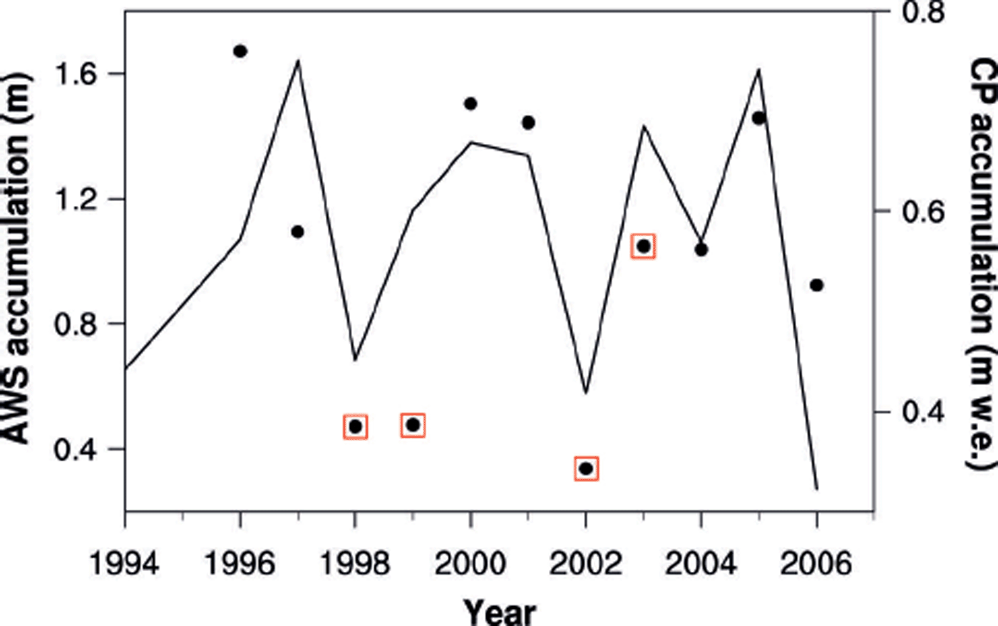
Fig. 4. Annual AWS accumulation (circles) and annual accumulation from the CP ice core (line); AWS observations with missing data are enclosed in red boxes.
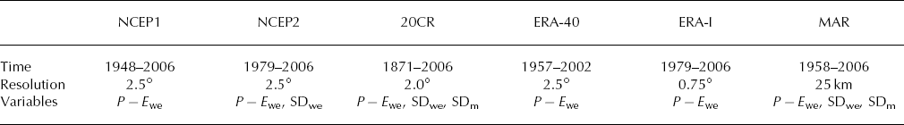
Simulated accumulation is derived from the reanalyses and regional model using two distinct methods that yield accumulated snow depth and/or precipitation minus evaporation (P – E). Accumulated snow depth from the gridded reanalyses is most comparable with AWS surface height data; however, several reanalyses exhibit major issues with this variable. The NCEP/NCAR (US National Centers for Environmental Prediction/US National Center for Atmospheric Research) reanalysis (NCEP1) has well-known problems with scaling of the snow depth parameter (Reference KanamitsuKanamitsu and others, 2002). ECMWF (European Centre for Medium-Range Weather Forecasts) Re-analysis (ERA-40) and ERA-Interim (ERA-I) nudge the snow depth parameter to climatology (Reference Betts, Ball and ViterboBetts and others, 2003; Reference DeeDee and others 2011), which distorts the accumulation. Fortunately, the NCEP/DOE (US Department of Energy) II (NCEP2) and the 20th Century Reanalysis (20CR) more accurately represent snow depth and are used for this study. For snow analysis, NCEP2 only ingests weekly snow cover derived from satellite images over the Northern Hemisphere, and provides model estimates of snow depth in w.e. (Reference KanamitsuKanamitsu and others, 2002). 20CR only assimilates surface pressure observations with prescribed sea surface temperatures to generate gridded model output (Reference CompoCompo and others, 2011). Thus, both of these reanalyzed variables are independent of the CP AWS data. This study examines the snow depth parameters from the 2° gridcell in 20CR (Reference CompoCompo and others, 2011) and the 2.5° gridcell in NCEP2 (Reference KanamitsuKanamitsu and others, 2002) corresponding to the CP site. Neighboring gridcells in the reanalysis data were also investigated since the CP site is located near the edge of its gridcell. The cells to the east exhibit similar variability in daily snow depth but, as expected, different overall magnitudes due to various gridcell characteristics (e.g. elevation, latitude). The adjacent gridcell to the west was more representative of the ablation zone of the GrIS as the snow depth parameter exhibited a steady decline. Only results from the corresponding gridcell are presented here as these are most relevant to the AWS site; however, it will be shown that CP accumulation contains a large-scale climate signal.
Reanalysis datasets are also used to define the lateral boundary conditions for regional-scale models such as the Modèle Atmosphérique Régional (MAR). Daily MAR output is available online for the GrIS from 1958 to 2013 (Reference Tedesco, Fettweis, Alexander, Green and DattaTedesco and others, 2013). The development of MAR is explained by Reference Gallée and SchayesGallée and Schayes (1994), and its configuration for the GrIS is described by Reference FettweisFettweis (2007). MAR runs at 25 km horizontal resolution, and its boundary conditions are driven by ERA-40 and ERA-I (Reference Tedesco, Fettweis, Alexander, Green and DattaTedesco and others, 2013). MAR has previously been used to explore surface mass balance over the GrIS (Reference RaeRae and others, 2012; Reference VernonVernon and others, 2013). Among other regional-scale models, MAR performs best for Greenland surface mass balance below 1500 m a.s.l.; however, above 1500 m MAR overestimates accumulation (Reference VernonVernon and others, 2013). Reference RaeRae and others (2012) suggest that regional-scale models with detailed snow schemes, such as MAR, tend to provide more accurate representations of Greenland surface mass balance than models without detailed snow physics.
The AWS and simulated snow depth data were aggregated monthly using two techniques. First, the average monthly snow depth was calculated by averaging the daily snow depth for each month. NCEP2 expresses snow depth in m w.e., 20CR contains two snow depth variables reported in m (snow) and m w.e., and the AWS and MAR express snow depth in m (snow). MAR also simulates snow density, which is used in this study to convert daily changes in MAR snow height (i.e. accumulation) into snow height in m w.e. In this study, variables expressing snow depth in m (snow) and m w.e. are represented by SDm and SDwe, respectively. Snowpack depth was adjusted for model recalibrations every 5 years for 20CR and every 1 year for MAR; adjustment was not necessary for NCEP2 as there appeared to be no recalibrations. The second aggregation technique involves the calculation of snow-depth-derived accumulation determined using the daily change in snow height (ΔSH), which was summed for each month. Similar to the snow depth, variables expressing changes in surface height in m (snow) and m w.e. are represented by ΔSHm and ΔSHwe, respectively. The terms snow depth and snow height are used interchangeably in this study; however, to clarify the abbreviations, depth is used for accumulated depth while height is used for accumulation (i.e. changes in depth/surface height).
The snow depth variables are most easily compared with the AWS observations of snow height; however, there are other methods of calculating accumulation (P – E). For the reanalysis datasets that contain unsuitable snow depth variables (NCEP1, ERA-40 and ERA-I), P – E can be used to calculate accumulation for comparison with the AWS accumulation determined from snow height changes. P – E may not be fully representative of snow height changes because it does not include factors such as melt, runoff, compaction and/or drift. Precipitation also includes both snowfall and rainfall. Rainfall would not be discernible in the AWS observations as it would not add to snow height. For NCEP1, NCEP2 and 20CR, precipitation cannot be separated into snowfall and rainfall, but for MAR, ERA-40 and ERA-I these variables are separate. Comparisons were made between P – E and S – E (snowfall minus evaporation); rainfall is virtually insignificant for the CP site. Evaporation was determined using the surface latent heat flux and the latent heat of vaporization at 0°C (L v = 2.501 × 10⁻⁶). Similar to some of the snow depth variables, P – E is expressed in m w.e. (P – E we). Table 1 summarizes the reanalysis and model products used in this study.
Table 1. Characteristics of reanalysis datasets and the regional model
Results
Seasonal accumulation variability
The monthly SDm from the AWS observations and simulated SDm and SDwe from MAR, 20CR and NCEP2 for 1995–2006 are shown in Figure 5. The magnitude of the simulated snow depth variables depends on when the model runs begin, similar to how the AWS snow height observations are initialized to zero upon installation. Thus, for direct comparison with the observations, the simulated snow depth is set to zero in June 1995, for which the first complete month of observational data is available after the AWS was installed at CP in May 1995.
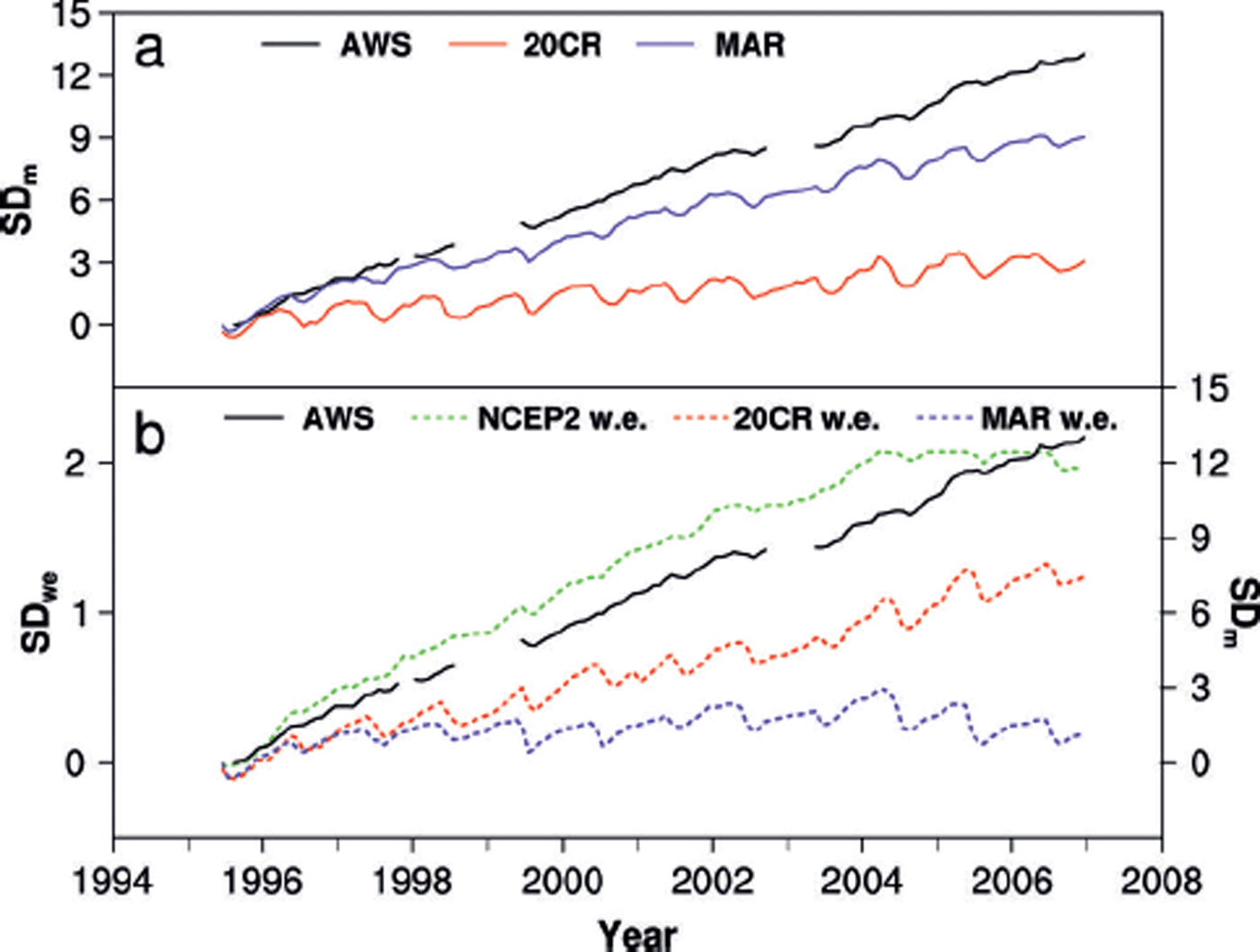
Fig. 5. (a) SDm from the AWS (black), 20CR (red) and MAR (purple) and (b) SDwe from NCEP2 (dashed green), 20CR (dashed red) and MAR (dashed purple) for the CP site.
All observations and simulations indicate that prior to 2007 CP was situated well within the accumulation zone of the ice sheet as the snow depth increases over the observational period. MAR and 20CR SDm underestimate the overall increase in snow height due to their overestimation of summer surface lowering (Fig. 5a). Reference HannaHanna and others (2011) found similar results, with too much evaporation over the GrIS in 20CR. Seasonal variations are more prevalent in the simulated data than observed by the AWS. The rate of snow depth increase is difficult to compare between AWS SDm and simulated SDwe, which requires knowledge of the snow density. The exaggerated seasonality does not appear in the NCEP2 SDwe (Fig. 5b), which unfortunately reaches a preset maximum threshold at about 2004, after which snow height can no longer increase. Although the threshold is an issue with the post-2004 NCEP2 SDwe, for 1995–2004 NCEP2 SDwe outperforms the other simulated data. The SDm (Fig. 5a) and SDwe (Fig. 5b) derived from MAR differ greatly, likely reflecting an error in the snow density variable.
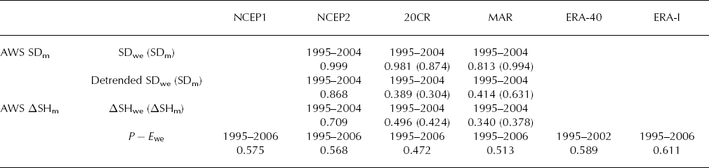
The 1995–2004 correlations between the observed (AWS) and simulated monthly snow depths all exceed 0.8 (Table 2), and NCEP2 slightly outperforms the others. These high correlation coefficients partially reflect the increasing nature of all these variables. Linearly detrending each variable better elucidates the intra- and interannual variability (not shown). As expected, the correlations for the detrended data are lower but still significant (p < 0.003). The detrended r values for MAR and 20CR versus the observations range from 0.30 to 0.63 for both SDm and SDwe, while the NCEP2 SDwe r value is 0.87 (Table 2). Since these variables are accumulated data there is an inherent autocorrelation, which explains the high correlation coefficients.
The snow-depth-derived accumulation records (ΔSHm and ΔSHwe) for the observations (AWS), reanalyses and regional model are similar, as expected given the strong relationship among the snow depth variables. Both ΔSHm and ΔSHwe from MAR and 20CR exaggerate the surface lowering during summer, which is not observed by the AWS. NCEP2 ΔSHwe does not overestimate the surface lowering and hence best represents the observations at this site. Correlations between ΔSHm from the AWS and ΔSHm and ΔSHwe from MAR and 20CR (not detrended) range from 0.34 to 0.49, while that for ΔSHwe from NCEP2 gives an r value of 0.71 (Table 2). These results are surprising as NCEP2 has the coarsest resolution (2.5°) compared with 20CR (2.0°) and MAR (25 km). Correlations for the monthly accumulated P – E we variables with the AWS ΔSHm are very similar among the datasets and range from r = 0.47 for 20CR to r = 0.61 for ERA-I (Table 2). All correlations are significant at the 99% level. Nevertheless, the NCEP2 ΔSHwe still performs best at the monthly timescale.
Table 2. Correlation coefficients between monthly AWS SDm and simulated SDwe (SDm) and between monthly AWS ΔSHm and simulated ΔSHwe (ΔSHm) and P – E we. All correlations are significant at the 99% confidence level
As the simulated accumulation data agree well with the AWS observations, they can be used to characterize the seasonal distribution of accumulation at the CP site. For 1995–2006, the AWS mean monthly ΔSHm shows maximum accumulation in autumn and spring and minimum accumulation in summer, with a slight surface lowering (i.e. negative accumulation) in June (Fig. 6a). The ΔSHm from 20CR and MAR clearly exaggerates surface lowering in the summer, as does their corresponding ΔSHwe variable (Fig. 6b). These 20CR and MAR variables suggest that ~40–90% of the total annual accumulation is removed by summer ablation which, if true, would negatively influence the ability of the CP ice core to preserve a robust climate history. Clearly, this is not the case as the AWS observations indicate that ablation only removes < 1% of the annual accumulation. This result is bolstered by the NCEP2 ΔSHwe which is very similar to the AWS ΔSHm. Although the AWS observations are in m and NCEP2 data are in m w.e., the zero accumulation line is the same, and NCEP2 ΔSHwe also shows a similar slight surface lowering in June (Fig. 6b). The simulated mean monthly P – E we shows similar patterns to the AWS ΔSHm with a maximum in autumn and a minimum in summer (Fig. 6c and d). NCEP1 P – E we shows considerably higher accumulation than the other datasets. P – E we from MAR and ERA-I are very similar as the MAR boundary conditions are driven by ERA-I during this time.
None of the accumulation records shows a summer maximum in accumulation, indicating that if a summer precipitation maximum exists it is offset by surface lowering, likely from increased melt and/or sublimation. Owing to the short AWS record, this analysis covers only 1995–2006, during which warming over Greenland has become more pronounced (Reference HannaHanna and others, 2008). To explore whether this pattern of summer surface lowering is a recent phenomenon, the reanalysis and model datasets that extend into the pre-1995 conditions can be examined to determine whether summer surface lowering was prevalent prior to 1995. Figure 7 shows the mean monthly accumulation for all the simulated accumulation variables. All the variables show a less-pronounced summer minimum prior to 1995, although the pre- and post-1995 difference is greater for some variables than others. The ΔSHm and ΔSHwe from 20CR and MAR still show considerable surface lowering in the summer months (Fig. 7a and b). The NCEP2 ΔSHwe, which showed slight lowering in summer for the post-1995 period, shows positive accumulation throughout the year (Fig. 7b) for the full simulation period (post-1979), although summer accumulation is still less than autumn and spring accumulation, similar to the post-1995 period. The P – E we accumulation for NCEP1 (Fig. 7c) shows a less pronounced summer minimum than in the post-1995 period, but P – E we from NCEP2 and 20CR shows very little difference between the periods. ERA-40 and ERA-I P – E we show much more muted summer minima in the pre-1995 period (Fig. 7d). MAR data remain similar to those from ERA-40 and ERA-I as these reanalyses define the MAR boundary conditions before and after 1979, respectively. Accumulation peaks in late summer and autumn for many of the variables; however, for most, the late-summer and autumn accumulation does not greatly exceed that of winter. These simulated accumulation records confirm the lack of a summer bias in accumulation at the CP site even though the summer lowering is more pronounced since 1995. The CP ice-core-derived A n may be slightly biased toward the autumn as most of the simulated data show higher autumn accumulation both before and after 1995.

Fig. 6. Post-1995 mean monthly accumulation from AWS observations (black), 20CR (red), MAR (purple), NCEP1 (orange), NCEP2 (green), ERA-40 (blue) and ERA-I (brown) for (a) ΔSHm, (b) ΔSHwe and (c, d) P – E we for the CP site.

Annual accumulation variability
Comparing the CP ice-core-derived A n and accumulation derived from the reanalyses and the model for the CP site confirms that both represent the annual signal well. Figure 8 shows the annual accumulation variables (ΔSHm ΔSHwe and P – E we) with the CP A n record. The simulated accumulation records clearly capture the interannual variability. Virtually all correlation coefficients among the accumulation variables (Table 3) are significant at the 99% confidence level. MAR ΔSHwe is the exception and, as previously mentioned, this likely reflects snow density errors. Variability in MAR P – E we is most closely related to variability in A n from the CP ice core (r = 0.66). Differences in magnitude between the in situ and simulated accumulation are not surprising as gridcell areal data are compared with a single point measurement (i.e. the CP ice core). Most of the datasets underestimate accumulation relative to that from the CP core. NCEP1 P – E we data are the exception (Fig. 8c) and this result is similar to that of Reference Chen, Johannessen, Wang and OhmuraChen and others (2011) who found that NCEP1 overestimated precipitation over the GrIS. Accumulation values derived from ΔSHm cannot be compared directly with the CP ice core A n since they are in different units (Fig. 8a). The ΔSHwe variables underestimate accumulation (Fig. 8b) more so than P – E we (Fig. 8c and d), although NCEP2 ΔSHwe is closer in magnitude to CP A n than ΔSHwe from MAR or 20CR. NCEP1 P – E we overestimates accumulation, while NCEP2 P – E we underestimates accumulation. The 20CR P – E we is close in magnitude to CP A n, but the difference increases after 1960 when 20CR accumulation exhibits a slight decreasing trend (Fig. 8c). P – E we from ERA-40, ERA-I and MAR most closely captures the magnitude of accumulation after 1960 (Fig. 8d). MAR is not independent of ERA-40 or ERA-I, although it is more highly correlated with the CP A n. Reference Chen, Johannessen, Wang and OhmuraChen and others (2011) found that among NCEP1, NCEP2, ERA-40 and ERA-I, only P – E we from ERA-I was able to accurately represent accumulation over West Greenland. Since MAR has a higher resolution and is laterally defined by ERA-I, its higher accuracy is not surprising. Correlations between CP A n and simulated seasonal accumulation time series were also calculated (not shown), but generally the correlation coefficients were stronger among the annual time series, which indicates that CP A n is an annual signal and not biased by any particular season.

Fig. 8. CP ice-core-derived A n (black) compared with annual simulated (a) ΔSHm, (b) ΔSHwe and (c) P – E we for 20CR (red), NCEP2 (green) and NCEP1 (orange) and (d) P – E we for ERA-40 (blue), ERA-I (brown) and MAR (purple) for the CP site.
Table 3. Correlation coefficients between CP ice-core-derived A n (m w.e.) and simulated ΔSHwe, ΔSHm and P – E we

At the CP site, the reanalyzed and modeled accumulation compare well with the in situ observations, and demonstrate the ability of both the gridded and point data to capture both sub-annual and interannual variability. This is surprising as the AWS and ice-core-derived accumulation are susceptible to local post-depositional effects, such as surface erosion and redeposition during snowdrifting. On the other end of the spectrum, most of the gridded fields are relatively low-resolution. The agreement among these records indicates the strong potential and feasibility in the upscaling representation of in situ accumulation and also the downscaling representation of the interpolated gridded accumulation.
The accumulation records from reanalyses and the AWS observations do not support a strong seasonal bias in net annual accumulation at the CP site. Thus the proxy records derived from the CP ice core should represent the annual climate variability without a discernible seasonal bias. One of the objectives for the CP ice core is to investigate the history of the NAO, which is primarily a winter phenomenon. Spatial correlations between CP A n and gridded annual mean sea-level pressure (MSLP) from ERA-I reveal the classic NAO structure, with positive correlations in the vicinity of the Icelandic low and negative correlations with the subtropical Azores high (Fig. 9). This analysis was repeated for seasonal MSLP (not shown), but the correlations are strongest for the annual timescale, indicating that CP accumulation is truly an annual signal. Thus, the annually resolved ice-core record from the west central Greenland site at CP is suitable for future investigations of large-scale climate variability, such as the NAO.

Fig. 9. Spatial correlations between the CP ice-core-derived A n and annual mean sea-level pressure from ERA-I for 1979–2006.
Conclusions
An ice core retrieved from CP in west central Greenland and extending back to AD 1766 with annual resolution affords the opportunity to investigate long-term changes in the major climate drivers of that region, including the NAO. The NAO is generally a wintertime phenomenon, and previous modeling studies as well as coastal precipitation records have suggested that west central Greenland receives more accumulation in the summer. This implies that proxy data from ice cores in this region may be biased toward climate conditions in summer. Modeling studies tend to analyze west central Greenland as one large region, although the dynamics on the topographically complex coast are likely to be quite different from those at higher inland sites. The ice-core-derived A n must adequately represent the winter climate to capture winter variability in the NAO, and thus it is important to confirm or refute the presence of a summer accumulation bias.
Surface height data from an AWS installed at CP in the mid-1990s reveal that the greatest increases in surface height (i.e. net accumulation) do not occur in summer. This indicates that either there is not a precipitation maximum in summer or that the precipitation maximum is being offset by other processes such as melt, sublimation and/or compaction that lower the ice-sheet surface. The monthly AWS record compares well with the accumulated snow depth from both the NCEP2 and 20CR reanalyses and the regional MAR model, although agreement is best with the NCEP2 data. The simulated accumulation records support the AWS-derived summer minimum in accumulation in the post-1995 period (Fig. 6) and demonstrate that although summer minima are more pronounced after 1995, prior to installation of the AWS in 1995, summer accumulation does not exceed that in other seasons (Fig. 7). The annual changes in simulated accumulation and A n from the CP ice core all agree well, demonstrating the strength of each record to reasonably represent the net accumulation of this region and their potential in further analysis of west central Greenland’s climate history. The snowpack variables (ΔSHm and ΔSHwe) and P – E we from reanalyses and the MAR regional model provide a simple technique for investigating the seasonality of accumulation at other locations in the accumulation zone of the ice sheet, although ideally this should be tested against AWS acoustic depth gauge measurements. The records from the CP site indicate no summer bias in accumulation and a modest autumn bias in accumulation. They demonstrate that west central Greenland ice cores are appropriate for reconstructions of climate variability and winter circulation patterns including the NAO. Future work with the CP ice-core record will investigate the past influence of the NAO over west central Greenland.
Acknowledgements
This work was supported by NAGS-5032 (US National Science Foundation (NSF)–CReSIS) and The Ohio State University’s Climate, Water and Carbon Program. We thank Jason Box and Konrad Steffen for providing the AWS snow height data. We acknowledge David Bromwich for thoughtful discussion and insight and thank two anonymous reviewers whose suggestions greatly improved the paper. The NCEP1, NCEP2 and 20CR data are available online (http://www.esrl.noaa.gov/psd/) from the US National Oceanic and Atmospheric Administration (NOAA) and the Earth System Research Laboratory’s (ESRL) Physical Sciences Division (PSD). ERA-40 and ERA-I data are from the European Centre for Medium-Range Weather Forecasts (ECMWF) data server (http://apps.ecmwf.int/datasets/). This is Byrd Polar and Climate Research Center contribution No.1437.


