


In March 1634 approximately 150 English settler-colonists landed on the shores of the St George's River (now St Mary's River), arriving in an area that had been home to Native peoples for at least 11 000 years. Following negotiations with the leadership of the Piscataway (the paramount chiefdom in the region) and Yaocomaco (an allied tribe living on both sides of St George's River), the English purchased 1000 square miles of Yaocomaco territory and formally established the colony of Maryland in a settlement they called St Mary's City (Miller Reference Miller, Miller and Parno2021). The colonists moved ashore and immediately began constructing St Mary's Fort. A letter penned by Maryland's first governor, Leonard Calvert, dated 30 May 1634, described the fort as a “pallizado of one hundred and twentie yarde square” located “within one half mile of the river” (Lee Reference Lee1889: 21).
Records from the colony's earliest years are sparse, but hint at a deteriorating situation. While some of the first descriptions record colonists and Yaocomaco engaged in trade and peaceful interaction, violence soon followed, culminating in the murder of the Yaocomaco tayac (chief) at the hands of an Englishman in 1642. By that time, the English had gained a foothold in southern Maryland, and St Mary's Fort was abandoned as colonists established tobacco plantations along the local waterways.
By the mid-seventeenth century the palisade of St Mary's Fort had been allowed to decay as the centre of St Mary's City shifted roughly a quarter of a mile west, where stores, offices, ordinaries and the colony's first statehouse were clustered. The city functioned as the colony's capital until 1694, when it was relocated to modern-day Annapolis (Miller Reference Miller, Miller and Parno2021). The former capital was gradually converted to farmland, preserving the evidence of millennia of Native American habitation, along with the archaeological and material remains of the seventeenth-century capital and eighteenth- and nineteenth-century plantations and their enslaved workforces. This exceptional degree of archaeological preservation led St Mary's City to be designated a National Historic Landmark in 1969.
St Mary's City has been the subject of ongoing archaeological investigation for nearly 50 years, led by staff of Historic St Mary's City (HSMC)—an on-site museum of living history and archaeology (Miller & Parno Reference Miller and Parno2021). Although this work has revealed much about early Maryland history, the location of St Mary's Fort remained elusive.
Geophysical survey
In 2018 HSMC commissioned a geophysical survey of two areas within the National Historic Landmark—referred to as the “Traditional Site” and the “Mill Field”—where early seventeenth-century artefacts had been previously discovered (Neiman et al. Reference Neiman, Miller and Stone1984; Riordan Reference Riordan1991; Miller et al. Reference Miller2006; Figure 1). A sequential strategy employing topsoil magnetic susceptibility magnetometry and ground-penetrating radar (GPR) was adopted to investigate a combined total area of 9ha with the aim of locating the fort and mapping associated features (Horsley Reference Horsley2019).
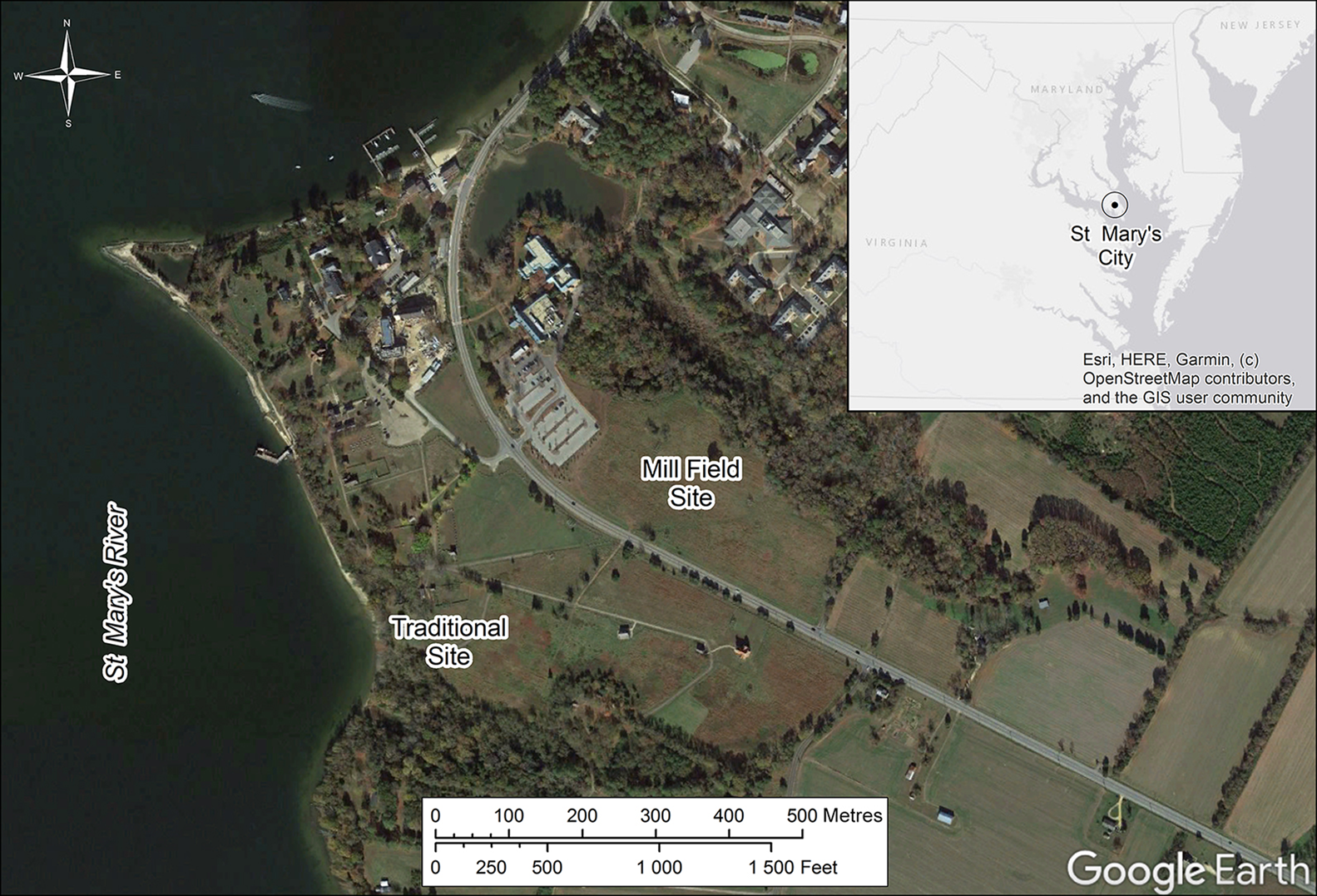
Figure 1. Satellite image of St Mary's City, Maryland, showing potential fort locations (credit: Horsley Archaeological Prospection LLC).
The magnetic susceptibility survey was conducted using a Bartington MS2 meter with field coil. As a reconnaissance tool, this method can reveal areas of former settlement as localised magnetic enhancement associated with burned soil and midden materials incorporated into the topsoil. Measurements were recorded at 10m intervals, closing to 5m upon encountering areas of enhancement. Higher magnetic values obtained across the Mill Field suggested more intensive pre- and/or post-colonial occupation than at the Traditional Site. There was, however, no clear indication of the fort's location in either area.
Subsequent magnetometer surveys were guided by the magnetic susceptibility results, as well as previously identified concentrations of colonial material and topographic features (see Neiman et al. Reference Neiman, Miller and Stone1984; Riordan Reference Riordan1991). In many settings, magnetometry is an effective method for mapping a range of buried cultural features, including hearths, pits, ditches and sometimes postholes. Magnetometry was undertaken using a Bartington Grad601-2 dual fluxgate gradiometer, with data collected at an interval of 0.125m along traverses spaced 0.5m apart.
Results from both sites are characterised by magnetic anomalies related to the underlying fluviomarine deposits, with little else distinguishable at the Traditional Site. In contrast, the Mill Field results revealed several distinctive responses caused by features associated with high temperature processes (e.g. furnaces and kilns), along with at least one brick foundation. A broad area of magnetic noise probably indicates the extent of historic activities in this field, but no palisade, ditch, or concentrations of settlement features can be discerned.
Although the combined magnetic susceptibility and magnetometer results suggested the Mill Field as the more likely location of St Mary's Fort due to the greater levels of activity, GPR surveys were conducted at both locations. A GSSI UtilityScan with 350MHz antenna was employed to collect samples at 0.02m intervals along traverses spaced 0.25m apart. Again, few cultural features were identified at the Traditional Site, but the results from the Mill Field revealed clear alignments of large postholes forming a rectangular palisaded enclosure (Figure 2). The enclosure measures 95 × 54m, or 104 × 59 yards—significantly smaller than the 120 yards square described in historical records. The presence of what appears to be a bastion projecting from the western corner and the excellent correlation with previously found artefacts, including cannon balls, gun parts and gunflints, however, strongly suggest that this is the remains of St Mary's Fort (Figure 3; see Riordan Reference Riordan1991). Patterns of probable postholes inside the enclosure are interpreted as indicating the locations of former structures; there is also evidence for cellared buildings, some of which are aligned with the enclosure and others with the later seventeenth-century town plan.

Figure 2. Composite of processed GPR time-slices corresponding to depths of 0.8–0.9m and 1.1–1.2m, revealing the palisade outline and other archaeological and natural features (credit: Horsley Archaeological Prospection LLC).

Figure 3. Simplified GPR interpretation with artefact overlay (credit: Horsley Archaeological Prospection LLC).
Ground-truthing the geophysical survey
In 2019, HSMC initiated excavations in the Mill Field to ground-truth the geophysical results. Excavation of units placed over portions of the north-western palisade wall and western bastion revealed a wide trench, averaging 0.6m across, which followed the alignment of postmolds identified by the GPR survey (Figure 4). Seven postmolds of full-, half- and quarter-timber posts reaching an average depth of 0.85m were located in a 3m section of the palisade trench. A small quantity of artefacts (n = 115) were recovered from the palisade trench fill, comprising primarily small pieces of charcoal, daub and brick. Of note were two handwrought iron nails, a single sherd of Iberian olive jar (c. sixteenth to eighteenth century) and a partial astragalus of a white-tailed deer (an animal the colonists hunted in great numbers in the earliest period of settlement; Miller Reference Miller1984).

Figure 4. Interpretation extract and palisade trench revealed through excavation (credit: Horsley Archaeological Prospection LLC and Historic St Mary's City).
HSMC continued excavating the site in 2020, this time targeting a deep, rectangular GPR anomaly identified as a potential cellared building. These excavations are ongoing and have so far revealed portions of a large timber-framed building with a previously backfilled cellar. Artefacts recovered during these excavations document much of the deep history of human occupation in southern Maryland (Figure 5). Early seventeenth-century artefacts found in the building's vicinity include sherds of Border ware (pre-1650), Iberian olive jar and chalky-pasted earthenware (c. 1635–1665), glass and cut-crystal trade beads, more than 75 pieces of lead musket shot of varying calibre and a 1633/1634 silver shilling.

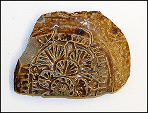
Figure 5. Sample of diagnostic artefacts recovered during 2020 excavations: top, from left) Lehigh/Koens-Crispin projectile point (c. 2500–1700 BC); Accokeek ceramic sherd (c. 900–300 BC); Rhenish stoneware sherd with applied rosette decoration (c. AD 1550–1650); bottom) obverse and reverse of King Charles I silver shilling with portcullis maker's mark (c. 1633–1634) (credit: Historic St Mary's City).
Future work
The 2018 geophysical survey and 2019–2020 excavations have confirmed the location of St Mary's Fort. To continue the study and public interpretation of this important site, HSMC, in partnership with members of the Piscataway community and other Indigenous and non-Indigenous stakeholders, has established the People to People Project. This collaborative initiative will bring together communities to investigate the history and archaeology of St Mary's Fort and nearby Archaic (c. 9500–1250 BC) and Woodland Period (c. 1250 BC–AD 1600) sites. The project team will design public interpretation and exhibits of Native and colonial cultures on adjacent archaeological sites, bringing the heritage of these two groups into conversation in new ways and highlighting their earliest interactions that set the stage for Maryland's history.
Funding statement
This work was supported by the Office of Governor Lawrence J. Hogan, the Maryland Historical Trust and the Historic St Mary's City Foundation.


