


INTRODUCTION
Delineating relationships between ice facies, structures and debris entrainment has proven to be an area of emerging interest for many researchers over the past two decades. This includes work at a range of glacier settings: Variegated Glacier, Alaska (Sharp and others, Reference Sharp, Jouzel, Hubbard and Lawson1994), Iceland (Cook and others, Reference Cook2010; Phillips and others, Reference Phillips, Finlayson and Jones2013), Greenland (Larsen and others, Reference Larsen, Kronborg, Yde and Knudsen2010), Svalbard (Lovell and others, Reference Lovell2015a, Reference Lovellb), European Alps (Hubbard and others, Reference Hubbard, Tison, Janssens and Spiro2000; Goodsell and others, Reference Goodsell, Hambrey and Glasser2005; Jennings and others, Reference Jennings, Hambrey and Glasser2014) and Sweden (Glasser and others, Reference Glasser, Hambrey, Etienne, Jansson and Pettersson2003; Moore and others, Reference Moore2013). Previous research has focused especially on structural controls on debris transport and entrainment within high-Arctic polythermal glaciers (Hambrey and others, Reference Hambrey, Bennett, Dowdeswell, Glasser and Huddart1999; Lovell and others, Reference Lovell2015a), with the analysis of the structural evolution of maritime alpine glaciers relatively rare (Appleby and others, Reference Appleby, Brook, Vale and MacDonald-Creevey2010; Phillips and others, Reference Phillips, Finlayson and Jones2013). Nevertheless, all of these studies have contributed to knowledge of strain histories and mechanisms of deformation, which is important in understanding the controls on foliation, folding and thrusting, and debris entrainment, transport and deposition (Moore and others, Reference Moore2013). A potential approach of investigating patterns and mechanisms of deformation within glaciers is the use of stable isotopes δD-δ18O (Glasser and Hambrey, Reference Glasser and Hambrey2002). This is because water undergoes isotopic fractionation on freezing, and so combined measurements of δD and δ18O provide the opportunity to distinguish between isotopically unmodified englacial or meteoric ice and isotopically modified basal ice (Souchez and Jouzel, Reference Souchez and Jouzel1984). Uplift of basal ice is thought to occur through bulk thickening, folding or thrusting (Alley and others, Reference Alley1997). Thrusting (and folding) in particular can juxtapose ice and sediment facies formed in very different englacial or basal environments, and may thus be responsible for the appearance of debris layers of basal origin overlying englacial ice of meteoric origin (Moore and others, Reference Moore2013). In theory, combined δD and δ18O measurements make it possible to distinguish between isotopically unmodified englacial ice and isotopically modified basal ice by plotting values of δD and δ18O (in ‰ relative to Vienna Standard Mean Ocean Water, VSMOW) on a co-isotopic diagram (Souchez and Jouzel, Reference Souchez and Jouzel1984). Samples of glacier ice that have not undergone refreezing as might, for example, basal ice or superimposed ice (Benn and Evans, Reference Benn and Evans2010), should lie along the same regression line as precipitation on a δD–δ18O covariance diagram. Ice that has undergone refreezing should produce a regression line with a lower slope, depending on the initial isotope values of the melted ice at the onset of regelation (Souchez and Jouzel, Reference Souchez and Jouzel1984; Glasser and Hambrey, Reference Glasser and Hambrey2002).
Despite this theory, δD–δ18O relationships with glacier structures and ice facies have hitherto remained untested in the mid-latitude maritime glaciers of the Southern Hemisphere. Based on prior studies (Glasser and Hambrey, Reference Glasser and Hambrey2002), the local meteoric water line (LMWL) can be assumed to represent unmodified meteoric ice, which inherits isotopic signature of precipitation, compared with ice facies, which have potentially undergone melting and refreezing. Thus, we hypothesize that comparison of the co-isotopic composition of debris-bearing glacier ice with the LMWL could potentially help constrain the debris entrainment process and structural deformation of Fox Glacier, New Zealand. This is a temperate maritime glacier on the western flank of New Zealand's Southern Alps. Recent observations by Appleby and others (Reference Appleby, Brook, Vale and MacDonald-Creevey2010) part-characterized the pattern of brittle and ductile structures developed on the glacier surface, and proposed that thrusting elevates basal debris along shear planes to the surface toward the glacier terminus during periods of advance. While the weight of evidence pointed to thrusting, the high ablation rates (>0.13 m d−1, Purdie and others, Reference Purdie, Brook and Fuller2008) on the lower glacier meant it was difficult to demonstrate large displacements along potential thrust planes. Here, we characterize in more detail from névé to terminus the surface structure of Fox Glacier, and sample δD and δ18O at 94 points on the glacier surface, across a range of different ice facies. We also acquired imagery from a time-lapse camera positioned in front of the terminus of Fox Glacier to observe the structural evolution of the terminus over a 3-week period during the peak of the ablation season. Taken together, this has provided an opportunity to test general theories regarding the origin of different glacigenic structures, during the 2010/11 survey period. The survey period followed the end of a two decade period (1984–2009) during which the glacier advanced 1 km down-valley, and thickened substantially (Purdie and others, Reference Purdie2014).
STUDY AREA
Fox Glacier (43°30′S; 170°10′E) is a 12.5 km long (in 2016; but 12.9 km long during the study in 2010/11) valley glacier, and is a sensitive indicator of climatic variations across a range of timescales from millennia-long glaciations to decadal and interannual variations (Purdie and others, Reference Purdie2014). The 36 km2 glacier is on the western side of the Southern Alps (Fig. 1), descending from the western face of Mount Tasman at ~2800 m a.s.l.. The broad high-elevation névé funnels ice down a steep narrow tongue, and terminates below 300 m a.s.l., far below its equilibrium line altitude (ELA) of ~1830 m a.s.l. (in 2010/11). The steep long-profile, broad accumulation area and narrow valley means the terminus responds rapidly to climate-induced changes in mass balance, of the order of 9 years (Purdie and others, Reference Purdie, Brook and Fuller2008). The Main Divide of the Southern Alps intercepts the dominant westerly airflow, resulting in up to 15 m w.e. a−1 precipitation in the accumulation area of Fox Glacier (Coates and Chinn, Reference Coates and Chinn1999). Thus, the overall catchment geometry and steep topography exert a control on the pattern of ice flow and glacier structures, which has been investigated by Purdie and others (Reference Purdie, Brook and Fuller2008) and Appleby and others (Reference Appleby, Brook, Vale and MacDonald-Creevey2010), although these studies were limited to the lower part of Fox Glacier. Ice is channeled rapidly down the upper icefall, before slowing where the valley slope decreases in a zone termed Victoria Flat (Herman and others, Reference Herman, Anderson and LePrince2011). The valley long profile then steepens down-glacier, and ice extends and flows rapidly down the lower icefall toward the terminus (Fig. 1).

Fig. 1. (a) Image and inset location map of Fox Glacier, as well as Invercargill, the closest monthly precipitation (including δD–δ18O) LMWL data from the IAEA's GNIP database. Position of time-lapse camera in front of the terminus is shown by the white circle. Image courtesy of ArcGIS Online World Imagery. (b) Summary structural glaciological map of Fox Glacier, and sampling locations for stable isotopes.
Although the overall recent trend of Fox Glacier (and nearby Franz Josef Glacier) has been one of retreat, there have been significant periods of re-advance during the 20th and early 21st centuries (Purdie and others, Reference Purdie2014). The most recent advance phase of 1 km (ending in 2009) provided a rare and ideal opportunity for the study of deformational structures and debris transfer during a glacier advance (see Appleby and others, Reference Appleby, Brook, Vale and MacDonald-Creevey2010). While measurements of these glacier length changes have been made with GPS, any ice-marginal moraines that are deposited are highly transient landforms, being typically destroyed by erosion from the proglacial river (Brook and Paine, Reference Brook and Paine2012; Purdie and others, Reference Purdie2014).
METHODS
Glacier structures
The structural glaciology of Fox Glacier was established by structural mapping of ~12 km-long surface based on overlapping aerial photographs. Structures were identified on the photographs according to their dimensions, orientation and cross-cutting relationships. In addition, structures were identified in the field and mapped on the ground using a compass/clinometer. Field data were collected from a series of transverse profiles from the accumulation zone to the terminus, using a similar survey pattern to that detailed in Goodsell and others (Reference Goodsell, Hambrey and Glasser2005). Data collected were foliation, primary stratification, various crevasse systems and crevasse traces. All structural glaciological data and description of the sequential development of glacier structures followed standard structural geological notation outlined in Goodsell and others (Reference Goodsell, Hambrey and Glasser2005). Hence, structures were coded from S 0 upwards, based on the presumed order of formation, in accordance with structural geology conventions (Hambrey and others, Reference Hambrey2005).
To monitor the temporal evolution of structures at the terminus, a sequence of daily images was collected from a time-lapse camera installed on the early 20th-century moraine (Wardle, Reference Wardle1973) on the south side of the proglacial zone, obliquely facing the glacier terminal face. This is a slightly elevated position above the braided proglacial valley floor. The images were used to capture a temporal record of structural glaciological processes at the terminus during a phase of glacier advance. The imagery was captured over a period of 3 weeks toward the end of the 2010 ablation season (from 22 March 2010 to 11 April 2010). This provided important glaciological context for the oxygen isotope data gathered during the present study, as well as allowing a comparison with the observations and measurements reported in the investigation of Appleby and others (Reference Appleby, Brook, Vale and MacDonald-Creevey2010).
Ice facies
Ice facies were identified and classified according to their physical characteristics following Goodsell and others (Reference Goodsell, Hambrey and Glasser2005) and Hubbard and others (Reference Hubbard, Cook and Coulson2009). Firn and englacial ice was classified at three main locations: firn in the accumulation zone, Victoria Flat (between the upper and lower icefalls) and in the lower glacier (between the lower icefall and terminus). Ice was also classified and sampled in the basal zone, in an accessible point on the north side of Victoria Flat.
Stable isotopes
Isotope samples were collected at a range of sites, which corresponded to the locations where ice facies were classified in situ. This allowed scope for elucidating possible relationships between stable isotopes and ice facies and/or structures (Fig. 1). The stable isotope sample sites included ice presumably of englacial origin, from a longitudinal transect along the glacier centerline, transverse transects across the névé to collect firn, basal ice along the northern glacier margin and ice from arcuate shear planes toward the terminus, previously assumed to include regelation ice (Appleby and others, Reference Appleby, Brook, Vale and MacDonald-Creevey2010). Samples were collected according to the methods outlined in Glasser and others (Reference Glasser, Hambrey, Etienne, Jansson and Pettersson2003), over a 2-day period during February 2011. At each sample site, firn or ice was removed from the glacier using an ice screw at 5–20 cm depth to avoid surface melting and stored in airtight plastic bottles in the shade to prevent evaporation. The altitude and location of each sample site was logged and the ice facies characterized. Along the longitudinal transect, sampling locations were irregularly spaced because parts of the upper and lower icefalls were largely inaccessible.
Samples were analyzed at the University of Canterbury using the Thermo Scientific Finnigan thermal combustion elemental analyzer coupled to a Thermo Scientific Delta V Plus isotope ratio spectrometer via a Conflo III gas distribution system. Operating conditions for the elemental analyzer were a reactor temperature of 1420°C, a gas chromatography column temperature of 40°C, with a 99.999% He continuous flow rate of ~110 ml min−1. Each sample including duplicate analyses was analyzed four times, and data were corrected using a 2-point normalization (i.e. stretch and shift) to the VSMOW-SLAP (VSMOW-Standard Light Arctic Precipitation; Gonfiantini, Reference Gonfiantini1978) scale. Using this process, the δD values were accurate to <1.0‰ and the δ18O values are accurate to <0.2‰. All regressions were calculated in IBM-SPSS v23 and plotted in Grapher 11.
The International Atomic Energy Agency (IAEA) provides details of isotopic contents (including δD–δ18O) of composite monthly precipitation on their Global Network of Isotopes in Precipitation (GNIP) database. The closest station to Fox Glacier is at Invercargill (46°24′S, 168°24′E, 5 m a.s.l.) at the southern tip of the South Island, and monthly values from this database (between 1977 and 2008) were used for comparison with δD–δ18O data from Fox Glacier. The GNIP data are expressed as the per mil (‰) deviation of the isotope ratio from the primary measurement standard. The measurements reported in GNIP have a long-term precision of ~±0.1‰ for δ18O and ±0.8‰ for δD, at one SD (IAEA, 1992). As the data were collected at sea level, they provide no information on the altitudinal variation of isotopic composition.
RESULTS
Structural glaciology
Glacier structures identified in the field and on the aerial photographs are summarized in Table 1. In a sense, the glacier typifies the structural patterns observed in many other alpine glaciers (Goodsell and others, Reference Goodsell, Hambrey and Glasser2005), insofar as it displays folding of primary stratification, and zones of crevasses in response to tension. In the névé, planar primary stratification (S 0) is visible in crevasse walls (Fig. 2a) undergoing firnification. Flow unit boundaries are also identifiable in the névé (Fig. 2b), each of which delineates the boundary between different subaccumulation basins. There is no evidence of debris septa developing, or any debris emerging, as this is above the ELA. The flow unit boundaries converge at the top of the upper icefall. Individual flow units cannot be traced any further down-glacier than this point. As ice is then channelized into the valley trough, and primary stratification (S 0) is compressed and attenuated into a series of folds whose axes are aligned along glacier, forming steeply dipping (80°–90°) fold limbs (Fig. 2c), designated longitudinal foliation (S 1). Hence, both S 0 and S 1 structures are end members of the same continuum.

Fig. 2. Details of typical glaciological structures at Fox Glacier. (a) S 0 primary stratification of firn in the accumulation zone. Note the development of transverse crevasses as ice accelerates down the upper icefall. (b) Flow unit boundary at confluence of Explorer Glacier (left) and Albert Glacier (right), below Pioneer Ridge. (c) Modified primary stratification (S 0) forming longitudinal foliation (S 1) exposed as isometric folds (hashed lines). (d) Open splaying crevasses (S 2) cutting across longitudinal foliation (S 0), both truncated by arcuate shear planes (S 3), interpreted as listric thrust faults. (e) Clayey material extruded at the surface along an S 3 arcuate shear plane. (f and g) Arcuate shear planes (S 3) at the terminus cross-cutting all existing structures, such as crevasses, crevasse traces.
Table 1. Summary of principal glaciological structures within Fox Glacier
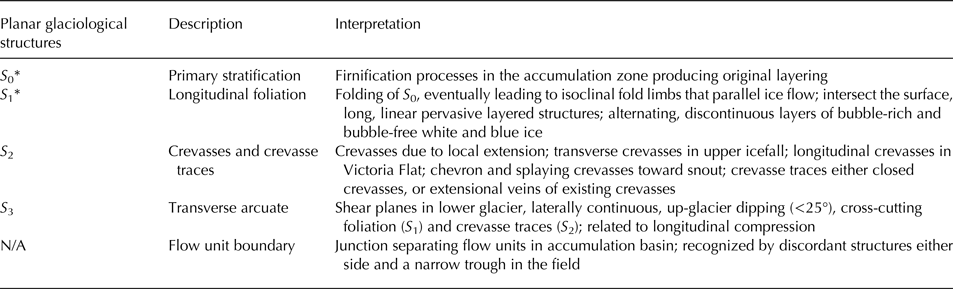
* S 0 and S 1 represent end members of a structural continuum.
Several different patterns of open crevasses (S 2) were observed across the glacier, and these relate directly to the orientation of the stress field within the glacier in a given time and space. Crevasses traces generally parallel adjacent open crevasses, indicating they are both forming along the stress–strain continuum, while other crevasse traces cross-cut the prevailing (open) crevasse pattern. Transverse crevasses, representing extensional flow, are first visible in the accumulation basins, where englacial ice and firn starts flowing toward the upper icefall (Fig. 2a, Table 1). Within both the upper and lower icefalls, crevasse morphology becomes obscured due to rapid surface melt (~13 cm d−1; Purdie and others, Reference Purdie, Brook and Fuller2008), and sérac development on the intervening ablating ice units. A series of crevasses and crevasse traces (S 2) are formed within the channelized section of the glacier in Victoria Flat, a ~2.5 km long zone of subdued ice surface topography between the upper and lower icefalls. Weak band ogives were previously identified in this zone (Appleby and others, Reference Appleby, Brook, Vale and MacDonald-Creevey2010), and form an arcuate pattern on the surface. Longitudinal crevasses also occur in Victoria Flat, due to lateral extension, given in the wider valley floor width. Splaying and chevron crevasses also occur here at the glacier margins.
Toward the terminus, both chevron, splaying and longitudinal crevasses can be identified (Fig. 2d), with arcuate shear planes (S 3) forming up-glacier dipping structures close to the terminus (Figs 2e–g). These shear planes are perpendicular and subperpendicular to ice flow, and dip at a low angle (15–25°) up-glacier, extending from the subglacial zone to the surface. At the surface, distinct hanging wall and footwall blocks can be identified (Fig. 2e). The shear planes appear to represent thrust faults, accommodating longitudinal shortening of the glacier, and truncate earlier structures. The temporal evolution of the shear planes was captured by time-lapse imagery in Figure 3. Over the period of observations, sequential images indicate that shearing along distinct planes occurs at the terminus. This is evident from the material being extruded from ice emerging along shear planes in the terminal ice cliff. This material then falls and flows under gravity, forming low ridges (0.5 m high) of morainic deposits, which are rapidly eroded by meltwater and rainfall.

Fig. 3. Two time-lapse images from the terminus of Fox Glacier from 22 March 2010 (image 1) and 11 April 2010 (image 2). Regarding the structural glaciology, a small (<2 m high) moraine is formed by bulldozing of proglacial sediment in the center of the terminus (arrowed in image 1). Sediment is also being extruded from low-angle shear structures at the far left and right of the images (boxed areas in image 2).
Ice facies
Four different firn/ice facies were identified and sampled in the field, and are summarized in Table 2. Coarse-crystalline, granular firn (Table 2) was ubiquitous across the accumulation zone, visible in pits and the walls of open crevasses. The englacial ice facies (Table 2) was observed at Victoria Flat, the lower glacier, and along a longitudinal profile down the glacier centerline. The englacial facies has an omnipresent stratification at centimeter to decimeter scales and takes the form of intercalated layers of bubble-rich and bubble-poor ice. This layering is visible on the glacier surface, and can be traced across the walls of crevasses by minor color changes. Englacial facies is for the most part, clean ice; however, occasional suspended grains and small clots of fine sediment are sometimes visible.
Table 2. Description of ice facies, sample zones and summary statistics of sampled δD–δ18O stable isotopes
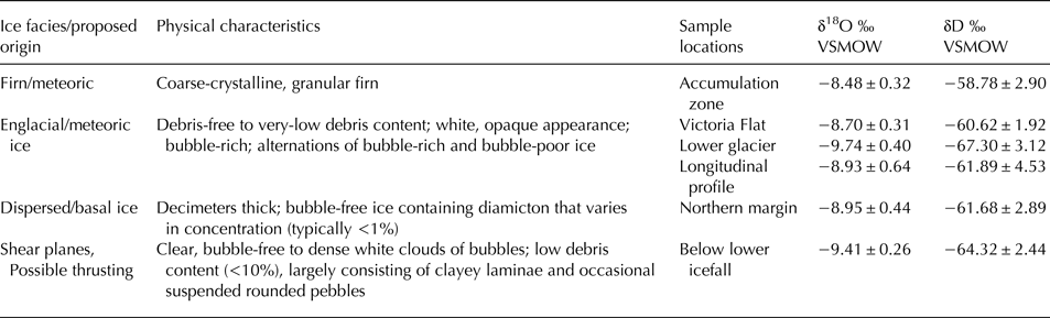
Physical characteristic descriptions follow Hubbard and others (Reference Hubbard, Cook and Coulson2009) and Fierz and others (Reference Fierz2009)
A dispersed ice facies (Table 2) was observed at the glacier bed at the northern margin of Victoria Flat, where a meltwater stream from the tributary Victoria Glacier catchment allows entrance to the subglacial zone via an ice cave. This facies clearly contrasted with the clean englacial ice. It consists of decimeters thick, typically bubble-free ice containing diamicton that varied in concentration and character (but typically <1%). Indeed, particle concentration and type varied, with suspended grains and clots of silt-sized fine sediment that occasionally form thin <2 cm bands. Rarely, clasts are entrained within the ice.
The third ice facies encountered is associated with the shear planes below the lower icefall toward the terminus. This facies, evident as shear plane ice, contrasts strongly with the overlying and underlying clean englacial facies. Indeed, the shear plane facies varies from clear, bubble-free ice, to dense white clouds of bubbles. It has a moderate debris content (<10%), largely consisting of a clayey laminae and rare, suspended rounded pebbles. The clayey laminae have a strong linear component, characterized by strong alignment of grains or clots of fine sediments. This facies typically forms planar, 3–5 cm thick bands, dipping up-glacier.
Stable isotopes
The GNIP stable isotope data from Invercargill are presented on a δD–δ18O co-variate plot in Figure 4, and shows a linear relationship described by a least-squares regression δD = 7.726δ18O + 7.355, R 2 = 0.92, p < 0.0001). These data probably hide considerable intraannual precipitation variability; however, they indicate the slope of the LMWL at Invercargill is 7.72, conforming closely to the slope of the global meteoric water line (GMWL). As the data are collected at Invercargill close to sea level, they provide no information on altitudinal variability of snowfall on the glacier, which descends from the Main Divide of the Southern Alps to ~300 m a.s.l. The 94 samples from Fox Glacier are also included on the plot, and despite the range in glacier surface altitude, the data and slope of the regression (6.81) closely correspond to the Invercargill LMWL and the GMWL.
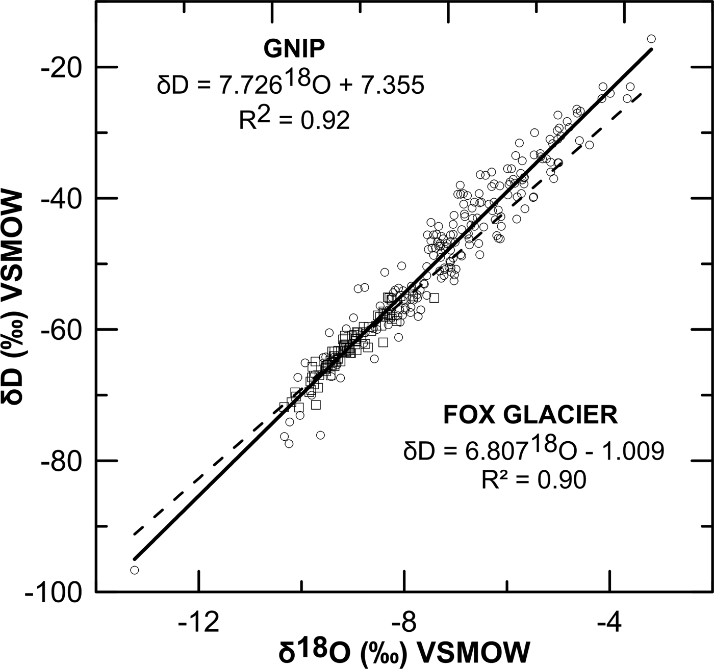
Fig. 4. Co-isotope scatterplot (δD–δ18O) of monthly precipitation recorded at Invercargill, South Island, New Zealand from the IAEA's GNIP database between 1977 and 2008 circles (solid regression line); also included on the plot are all data from this study (squares) and associated linear regression (hashed line).
Mean and SDs of δD and δ18O for each of the sample facies are presented in Figure 5 and Table 2. As is expected, there is substantial overlap between some of the sample facies. The firn facies from the névé appears to show more positive isotope values compared with all other datasets, while the englacial facies from Victoria Flat is the most clustered. Absolute δD values range between −54.92 and −71.83‰, with an overall mean of −62.54‰. Absolute δ18O values range between −7.97 and −10.33‰, with an overall mean of −9.06‰. For both δD and δ18O, the englacial ice facies sampled on the lower glacier displays the highest mean values (δ18O = −9.74‰, δD = −67.30‰), while the firn facies in the névé displays the lowest mean values (δ18O = −8.48‰; δD = −58.78‰). There does appear to be a degree of heterogeneity between different englacial facies, with the englacial ice facies sampled at Victoria Flat closest isotopically to the firn facies from the névé. The δD–δ18O relationships for different facies are explored further in the co-isotopic scatterplots in Figure 6. None of the stable isotope measurements are as heavy as the precipitation-derived data at Invercargill (Fig. 5).
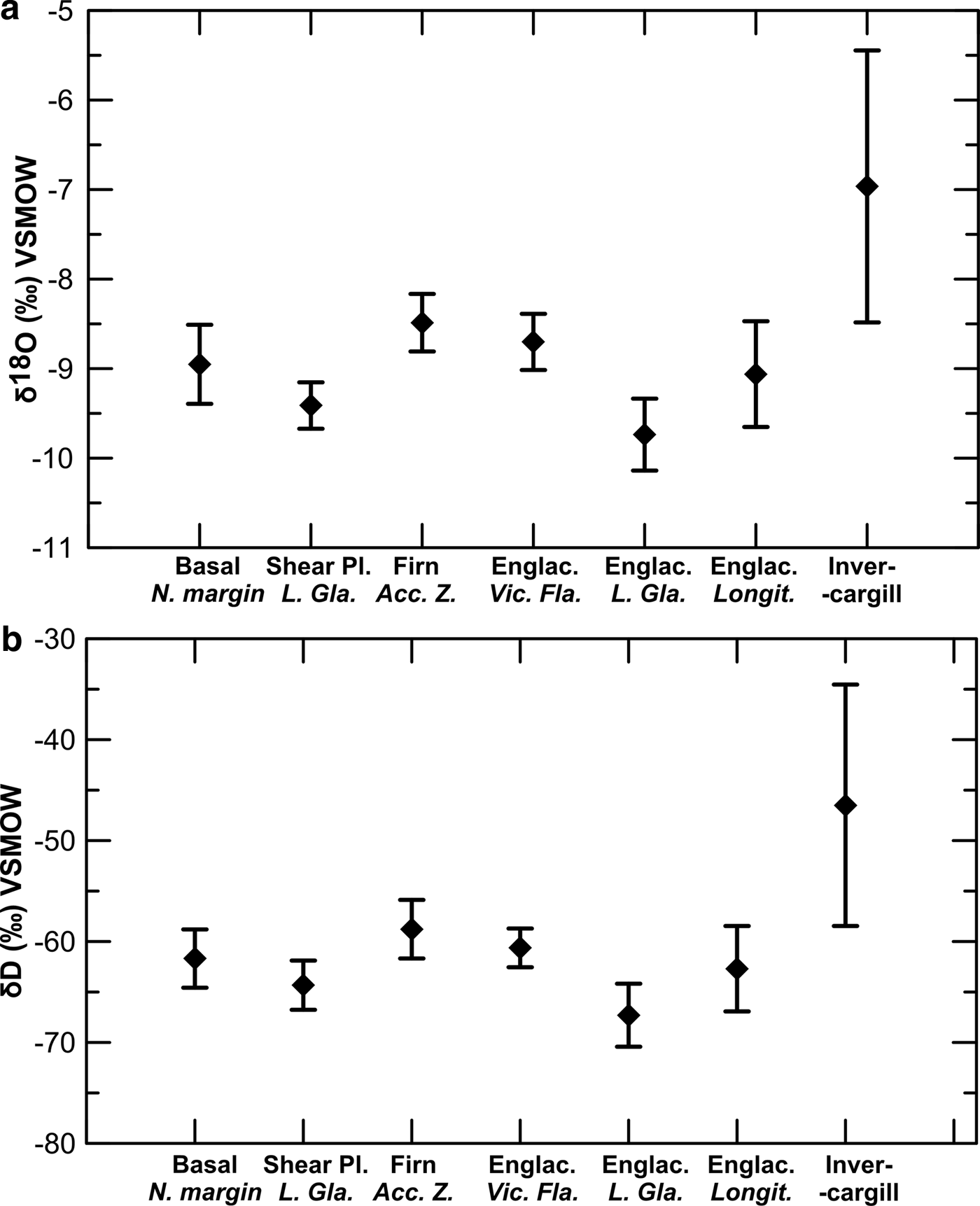
Fig. 5. Summary mean and SD of (a) δD and (b) δ18O samples at Fox Glacier for different sampling locations and ice facies.

Fig. 6. Co-isotopic scatterplots of oxygen and deuterium (δ18O and δD) from the following ice facies/sampling zones at Fox Glacier: (a) basal ice; (b) shear plane ice below the lower icefall; (c) firn from the accumulation zone; (d) englacial ice at Victoria Flat; (e) englacial ice in the lower glacier; and (f) all longitudinal englacial samples (accumulation zone, Victoria Flat and lower glacier). Each plot shows the 95% confidence intervals about the least-squares linear regression model and corresponding R 2 values.
The basal ice facies was sampled directly at the northern lateral margin of the glacier, but there appears to be no clear differentiation between δD–δ18O relationship for this ice facies and the regression slopes of englacial or meteoric (i.e. firn) facies. Indeed, the basal ice facies δD and δ18O data are clustered tightly around a regression slope of 6.33 (Fig. 6). The δD–δ18O relationship of the shear plane ice facies indicates that this facies appears to show a slightly different stable isotope signal when compared with other surrounding englacial ice facies on the lower glacier (Fig. 6). In particular, the shear plane ice facies is isotopically heavier than the surrounding englacial facies.
Nevertheless, the scatter of data and range of δD–δ18O relationships displayed in Figure 6 for the different ice facies are difficult to distinguish clearly. All the regression slopes are close to the LMWL and GMWL, apart from the englacial facies sampled at Victoria Flat and basal ice facies (regression slopes of 5.065 and 6.330, respectively). A contrast does exist between the regression slopes of firn (7.869) and the englacial ice facies (5.065) sampled at Victoria Flat, but the reasons for this are unclear, given they are both presumably of meteoric origin. Nevertheless, all of the regressions confirm strong, statistically significant (p < 0.001) relationships between δD and δ18O (Table 3), as confirmed by the R 2 and F-statistic values. The 95% confidence ranges in b 1 (δ18O) coefficients (Table 3) could be used to determine whether significantly different relationships exist as a function of ice facies. However, the b 1 ranges for each facies overlap, which suggests that the relationships are not significantly different. Nevertheless, a t test does reveal a statistically significant difference (at p < 0.01) between more positive isotopic values in the shear plane ice facies than the surrounding clean englacial facies on the lower glacier, for both δ18O and δD.
Table 3. Statistics for best-fit linear regression relationships between δD and δ18O
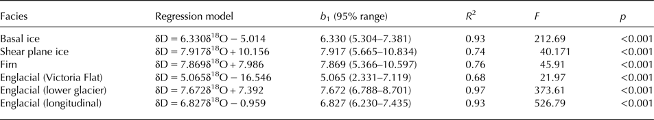
The 95% range for b 1 (δ18O) coefficient is calculated as the mean ±2 standard errors of the estimate. p is the significance level at which R 2 and F are significant.
Variations in the δD–δ18O relationships are also apparent with altitude along Fox Glacier, using the longitudinal englacial facies and firn data from along the glacier centerline (Fig. 7), although the results do not exhibit uniform spatial patterns of heavier or lighter isotopes. A possible trend of a more positive isotopic signal with increasing altitude into the névé does occur, but the altitudinal scatter of δD–δ18O data becomes increasingly heteroscedastic around the regression toward the glacier terminus.
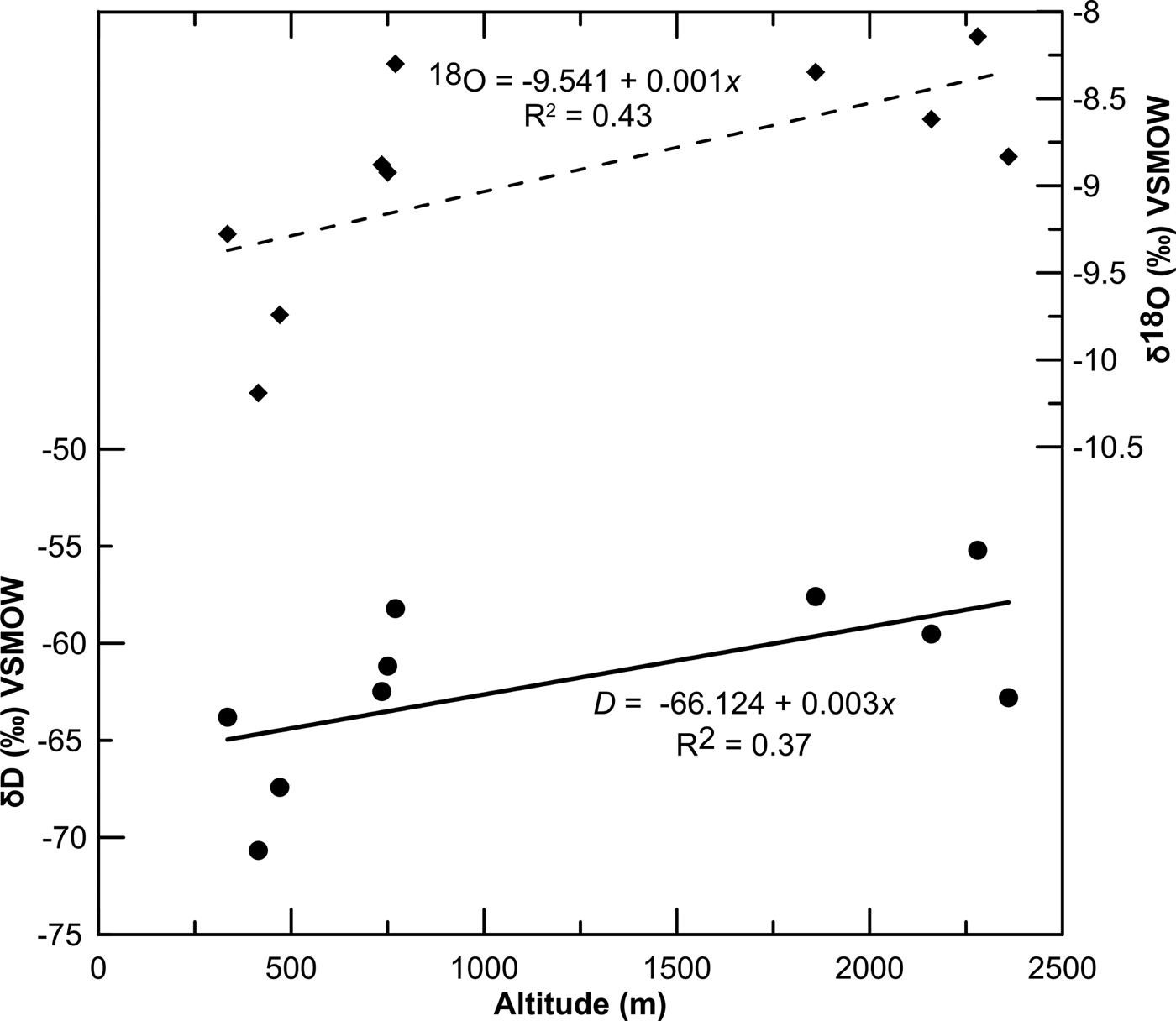
Fig. 7. Altitudinal variation in mean δ18O (top) and δD (bottom) from samples along the longitudinal transect at Fox Glacier.
DISCUSSION
The pattern and distribution of observed glacier structures at Fox Glacier is typical of those reported from other valley glaciers, with large accumulation zones and steep long profiles (Hambrey and Lawson, Reference Hambrey and Lawson2000). The primary stratification (S 0) evident across the accumulation zone is then tilted and deformed by transport from this broad névé into the narrow trunk, and then via flow through the upper and lower icefalls. Foliation (S 1) is a pervasive planar structure found in almost all glaciers (Hambrey and Lawson, 2000), and at Fox Glacier, it is tilted at high angles as isoclinal fold limbs. It is visible across the glacier surface as alternating layers of bubble-rich and bubble-free ice, formed under laterally compressive and longitudinally tensile stresses (Hambrey, Reference Hambrey1975), and ‘transposes’ the original primary stratification (S 0). Indeed, foliation does not appear to cross-cut primary stratification, implying that foliation evolves from primary stratification (Roberson, Reference Roberson2008). Both crevasses and crevasse traces (S 2) are ubiquitous features of most glaciers (Hambrey and others, Reference Hambrey2005), with the style of crevassing in Fox Glacier typical of alpine valley glaciers. Indeed, zones of extending flow (Herman and others, Reference Herman, Anderson and LePrince2011) cause crevassing to develop in the upper and lower icefalls. Chevron and splaying crevasses are prevalent toward the glacier margins, caused by friction with the valley side (Benn and Evans, Reference Benn and Evans2010), and transverse crevasses in areas of longitudinal extension, such as above icefalls. Longitudinal crevasses also develop at Victoria Flat, and near the terminus, due to the wider valley floor accommodation space, allowing lateral extension. Arcuate, up-glacier dipping debris-bearing shear planes (S 3) near the terminus have been interpreted previously by Appleby and others (Reference Appleby, Brook, Vale and MacDonald-Creevey2010) to represent longitudinal shortening and possible thrusting.
For most of ice facies (apart from englacial samples at Victoria Flat), the stable isotope samples approximate the LMWL, with a δD–δ18O slope of 6.8 and 7.7 for Fox Glacier and Invercargill, respectively. The slope of the firn facies (S 0) samples (7.9) is particularly close to the monthly GNIP data at Invercargill, indicating that the névé has not undergone significant isotopic modification since direct snowfall. Although strong spatial variability in the isotopic composition of precipitation occurs across New Zealand, leading to more enriched δD–δ18O values northwards (Barbour, Reference Barbour2007; Amesbury and others, Reference Amesbury2015), both Fox Glacier and Invercargill are in a cooler climate, more dominated by the prevailing southern ocean westerly winds.
It is important to contextualize these results, as the isotopic composition of ice and firn is usually used in glaciology to interpret the formational history of glacier ice and firn, as well as debris entrainment mechanisms (Souchez and Jouzel, Reference Souchez and Jouzel1984; Souchez and de Groote, Reference Souchez and de Groote1985; Lawson and others, Reference Lawson1998; Glasser and others, Reference Glasser, Hambrey, Etienne, Jansson and Pettersson2003). While some previous studies have focused on temperate glaciers (Epstein and Sharp, Reference Epstein and Sharp1959; Sharp and others, Reference Sharp, Epstein and Vidziunas1960; Hambrey, Reference Hambrey1974; Lawson and Kulla, Reference Lawson and Kulla1978; Lemmens and others, Reference Lemmens, Lorrain and Haren1982; Stichler and others, Reference Stichler, Baker, Oerter and Trimborn1982; Goodsell and others, Reference Goodsell, Hambrey and Glasser2005; Swift and others, Reference Swift, Evans and Fallick2006; Cook and others, Reference Cook2010), few, if any, previous studies have focused on mid-latitude, temperate maritime alpine glaciers. This provides limited scope for interpreting the thermal history of glacier ice at Fox Glacier in the context of directly comparable previous work. Nevertheless, in comparison with Purdie and others (Reference Purdie, Bertler, Mackintosh, Baker and Rhodes2010) at adjacent Franz Josef Glacier, both the 94 δD and δ18O values sampled from the different facies and locations at Fox Glacier span a relatively small range, between −54.92 to −71.83‰, and −7.97 to −10.33 for δD and δ18O, respectively. These data closely correspond to the data ranges reported by Purdie and others (Reference Purdie, Bertler, Mackintosh, Baker and Rhodes2010) for Franz Josef Glacier snowfall data, which span from −9.38 to −14.28 (mean −14.28) for δ18O, and from −57.80 to −177.30 (mean −102.04) for δD (Purdie and others, Reference Purdie, Bertler, Mackintosh, Baker and Rhodes2010: p. 4742). The Fox Glacier ice facies isotope data generally show more positive values than the Franz Josef snowfall data, suggestive of fractionation.
Indeed, since water undergoes isotopic fractionation on freezing, measurements of δD–δ18O can be used to distinguish between isotopically unmodified surface glacier ice and isotopically modified basal ice (Souchez and Jouzel, Reference Souchez and Jouzel1984; Lehmann and Siegenthaler, Reference Lehmann and Siegenthaler1991; Glasser and others, Reference Glasser, Hambrey, Etienne, Jansson and Pettersson2003; Moore and others, Reference Moore2013; Lovell and others, Reference Lovell2015a, Reference Lovellb). The stable isotope composition of the shear plane ice samples (S 3) shows more positive values when compared with the juxtaposed clean ice in the lower glacier, indicating that freezing of interstitial ice water as the debris was elevated from the subglacial zone has occurred (Moore and others, Reference Moore2013). Indeed, this is consistent with ice formation through refreezing of water in close association with a debris-rich bed, as reported by other authors (Lawson, Reference Lawson1979; Hubbard and Sharp, Reference Hubbard and Sharp1993; Iverson and Souchez, Reference Iverson and Souchez1996). Basal ice sampled at the glacier margin also appears slightly more enriched than englacial ice sampled at Victoria Flat and the lower glacier, the latter being particularly depleted. This contrasts with the surrounding englacial ice sampled in Victoria Flat and the ablation zone, which is interpreted at meteoric ice formed by the firnification of snow in the glacier's accumulation area, with the alternating bubble-poor and bubble-rich layers reflecting seasonal melting and refreezing (cf. Hambrey, Reference Hambrey1975).
Despite this, the co-isotope plots, along with subsample means and SDs of each sample facies, suggest that there are only subtle differences between ice facies. The relative ‘homogenization’ of co-isotope values across the different sample facies may have resulted from isotopic modification of the snowpack during the transformation from firn to ice, perhaps through the percolation of surface meltwater, or from melting/refreezing events within the snowpack itself (Glasser and Hambrey, Reference Glasser and Hambrey2002). Samples of glacier ice that have not undergone refreezing should lie along the same regression line as precipitation (normally with a slope of ~8) when plotted on a δD–δ18O diagram. However, plotting the means and SD of the Fox Glacier facies together, there is only a subtle differentiation between the different ice types, although all show enrichment relative to the Franz Josef Glacier winter snowfall data reported in Purdie and others (Reference Purdie, Bertler, Mackintosh, Baker and Rhodes2010). This suggests that the ice facies in general have a common origin. Neither the coarse-bubbly ice facies, the coarse-clear ice facies, nor the debris-rich clotted ice in the shear planes (S 3) appear to have clearly undergone isotopic fractionation by the incomplete freezing of available water (see Lawson and others, Reference Lawson1998). Hence, invoking processes of melting and refreezing in one ice facies relative to another is problematic with the Fox Glacier dataset.
An additional issue at glaciers, such as Fox Glacier, in interpreting δD–δ18O values is caused by the heavily crevassed regions in the ablation zone, which reach near or fully to the glacier bed. Hence, the amount of rainwater able to reach the subglacial drainage system, and in turn melt subglacial ice via advection of the relatively warm water, will be high (Alexander and others, Reference Alexander, Shulmeister and Davies2011).
The stable isotope data outlined above, along with surface observations and the time-lapse imagery of the terminus, clearly have implications for debris entrainment and transfer. Debris entrainment and thrusting has been cited by several authors as an important mechanism in transporting sediment upwards from the bed. Most researchers who invoke thrusting suggest that hanging walls of fast-sliding ice are thrusted over footwalls of stagnant or slow-moving marginal ice in a longitudinally compressive environment at glacier termini (cf. Hudleston, Reference Hudleston2015). Despite its widespread application, the thrust model for the uplift of basal debris, and criteria for the field recognition of thrusts, is debated (Weertman, Reference Weertman1961; Hooke and Hudleston, Reference Hooke and Hudleston1978; Woodward and others, Reference Woodward, Murray and McCaig2002; Glasser and others, Reference Glasser, Hambrey, Etienne, Jansson and Pettersson2003; Rea and Evans, Reference Rea and Evans2011). While Weertman (Reference Weertman1961) argued that sediment transfer along thrusts would be inefficient, a growing body of work from polythermal glaciers in Svalbard (Glasser and others, Reference Glasser, Hambrey, Crawford, Bennett and Huddart1998, Reference Glasser, Bennett and Huddart1999; Glasser and Hambrey, Reference Glasser and Hambrey2001) and Storglaciaren, Sweden (Moore and others, Reference Moore, Iverson and Cohen2010, Reference Moore2011, Reference Moore2013) indicates that thrusting can be an important mode of elevating basal and glaciofluvial debris to the ice surface from subglacial and englacial positions. Work on alpine glaciers in the European Alps (Goodsell and others, Reference Goodsell, Hambrey and Glasser2005; Herbst and others, Reference Herbst, Neubauer and Schopfer2006) reported accumulations of basal material similar to that described at Fox Glacier on the surface of Pasterzenkees, Austria and Haut Glacier d'Arolla, Switzerland. Three glaciotectonic processes likely to elevate debris to the surface have been proposed by Glasser and others (Reference Glasser, Hambrey, Etienne, Jansson and Pettersson2003): (1) large-scale recumbent folding, (2) compression caused by a thermal boundary between a thawed and deforming bed and (3) over-riding of ice-marginal stagnant ice. These proposals are rejected for Fox Glacier on the basis of observations herein, together with the high ice velocities at the terminus (~1 m d−1; Purdie and others, Reference Purdie, Brook and Fuller2008), and the meltwater availability. Instead, a model of thrusting caused by the glacier advancing into an aggraded proglacial foreland (Herbst and others, Reference Herbst, Neubauer and Schopfer2006), according to the observed structural characteristics, would appear to be a more realistic scenario.
These results have highlighted the range in meteoric-derived water stable isotopic compositions within New Zealand's dynamic maritime climate system. Indeed, the ranges in δD at Fox Glacier are around one-half the range of δD values seen in the polar ice cores from the Last Glacial Maximum (LGM) to the late Holocene (Winter and others, Reference Winter2016). Hence, these ranges in maritime alpine glacier stable isotopic compositions make them potentially useful targets for tracing glacier deformation processes, if careful isotope sampling from clearly established ice facies identified within the glacier system (Hudleston, Reference Hudleston2015) is undertaken.
CONCLUSIONS
Evidence for flow dynamics and deformation at Fox Glacier, a temperate, mid-latitude maritime glacier are evident from time-lapse imagery, surface observations and stable isotope sampling in 2010/11, at the end of the most recent period of advance (1984–2009). The stable isotopes show contrasts between the debris-bearing shear plane facies and values typical of clean englacial facies. In common with many other alpine valley glaciers with a high AAR, ice is highly deformed due to topographic constriction within a channelized valley, in addition to a steep, undulating long profile. The sequential development of structures within the glacier consists of: (1) the formation of primary stratification through firnification processes in the accumulation area; (2) folding of primary stratification to produce longitudinal foliation; (3) opening of extensional fractures and crevasses, some of which close to form crevasse traces; (4) arcuate debris-bearing shear planes close to the terminus due to longitudinal compression, with apparent hanging wall and footwall fault blocks, characteristic of thrust faulting.
The stable isotope samples are plot on a line with a slope of 6.8 on a co-isotopic plot of δD and δ18O. This line closely approximates the LMWL (7.7) obtained from monthly precipitation data collected by the IAEA at Invercargill, at the southern tip of the South Island. Moreover, the slope of the Fox Glacier névé samples (7.9) is particularly close to the monthly LMWL data at Invercargill, indicating that the névé has not undergone significant isotopic modification from direct snowfall. In addition, all of the Fox Glacier facies sampled either overlap, or are close to the maximum values of the isotope data reported in a prior study of winter snowfall on the adjacent Franz Josef Glacier. Comparing the co-isotopic plot slope gradients and regression statistics shows that some slopes are less steep than others, with the shear plane ice at the terminus having the steepest line (7.9), and Victoria Flat englacial facies having the lowest gradient (5.1). However, the difference in these relationships was not statistically different, given the limited sample sizes. Nevertheless, the stable isotope composition of the shear plane ice facies shows slightly more positive values when compared with the nearby englacial ice samples, indicating that freezing of interstitial water has occurred as the debris was elevated from the subglacial zone. This accords with ice formation through refreezing of water in close association with a debris-rich bed, as reported elsewhere.
ACKNOWLEDGEMENTS
Discussions in the field at Fox Glacier with Mike Hambrey (University of Aberystwyth) and Peter Barrett (Victoria University of Wellington) is gratefully acknowledged. The research was funded by Massey University Research Funding (MURF) to M.S.B., and a Vice Chancellor's Massey University PhD Scholarship to J.R.A.. We are indebted to the very detailed comments of an anonymous reviewer, who helped to substantially improve this paper.


 Open access