


Introduction
The snow cover on sea-ice floes is an important component of the air-ice-ocean system. Due to its high albedo, snow affects the surface energy balance and, together with its excellent insulating properties, influences the ice thermal regime and growth rates at the ice/ocean interface. A sufficient snow load will depress the ice below sea level, causing flooding at the snow/ice interface; subsequent freezing of the sea-water-soaked snow leads to snow-ice formation. Snow depth affects light transmission through the ice and influences biological productivity in the ice and water. Accumulating snow modifies the roughness of the ice surface and thus momentum transfer between the atmosphere, ice and ocean. The retrieval of sea-ice geophysical parameters from remote-sensing data is influenced by the seasonally variable scattering properties and emissivity of the snow cover.
Understanding the role that snow plays in air-ice-ocean interactions requires a fundamental knowledge of its basic physical characteristics. In Antarctica, in recent years, there has been some progress in this regard. The characteristics of the winter snow cover onWeddell Sea and East Antarctic sea ice (Reference Massom, Drinkwater and HaasMassom and others, 1997,Reference Massom, Lytle, Worby and Allison1998), and on Ross, Amundsen and Bellingshausen sea ice (Reference Sturm, Morris, Massom and JeffriesSturm and others, 1998), have been described. There have been less detailed studies of the summer snow cover on floes in the Ross, Amundsen and Bellingshausen seas Reference Jeffries, Veazey, Morris and KrouseJeffries and others, 1994; Reference AldworthAldworth, 1995; Reference Haas, Rebhan, Thomas, Viehoff, Miller and GrobeHaas and others 1996,Reference Haas, Thomas, Steffens, Bareiss, Jokat and Oerter1998) and of the autumn snow cover on Weddell Sea ice (Reference Drinkwater and LytleDrinkwater and Lytle, 1997). These studies have revealed considerable spatial and temporal variability in the characteristics of the snow cover, and modellers are beginning to incorporate this new knowledge into simulations of Antarctic sea-ice processes (Reference Wu, Budd, Lytle and MassomWu and others, 1999).
Further understanding of the temporal variability and evolution of the snow cover requires studies during the same annual cycle in the same region. Cruises aboard the R/V nathaniel b. palmer in autumn 1998 (May-June) and summer 1999 (January) allowed us the opportunity to investigate seasonal differences in snow depth, extent of flooding at the snow/ice interface and snow salinity, temperature, density, grain morphology and size, and thaw/freeze features.
Data and Methods
Two cruises, which extended from the ice edge to the continent and back, were undertaken: the first in late autumn (May-June) 1998 and the second in summer (January-February) 1999 (Fig. 1). An excursion into Terra Nova Bay was also made along 75° S during the first cruise.
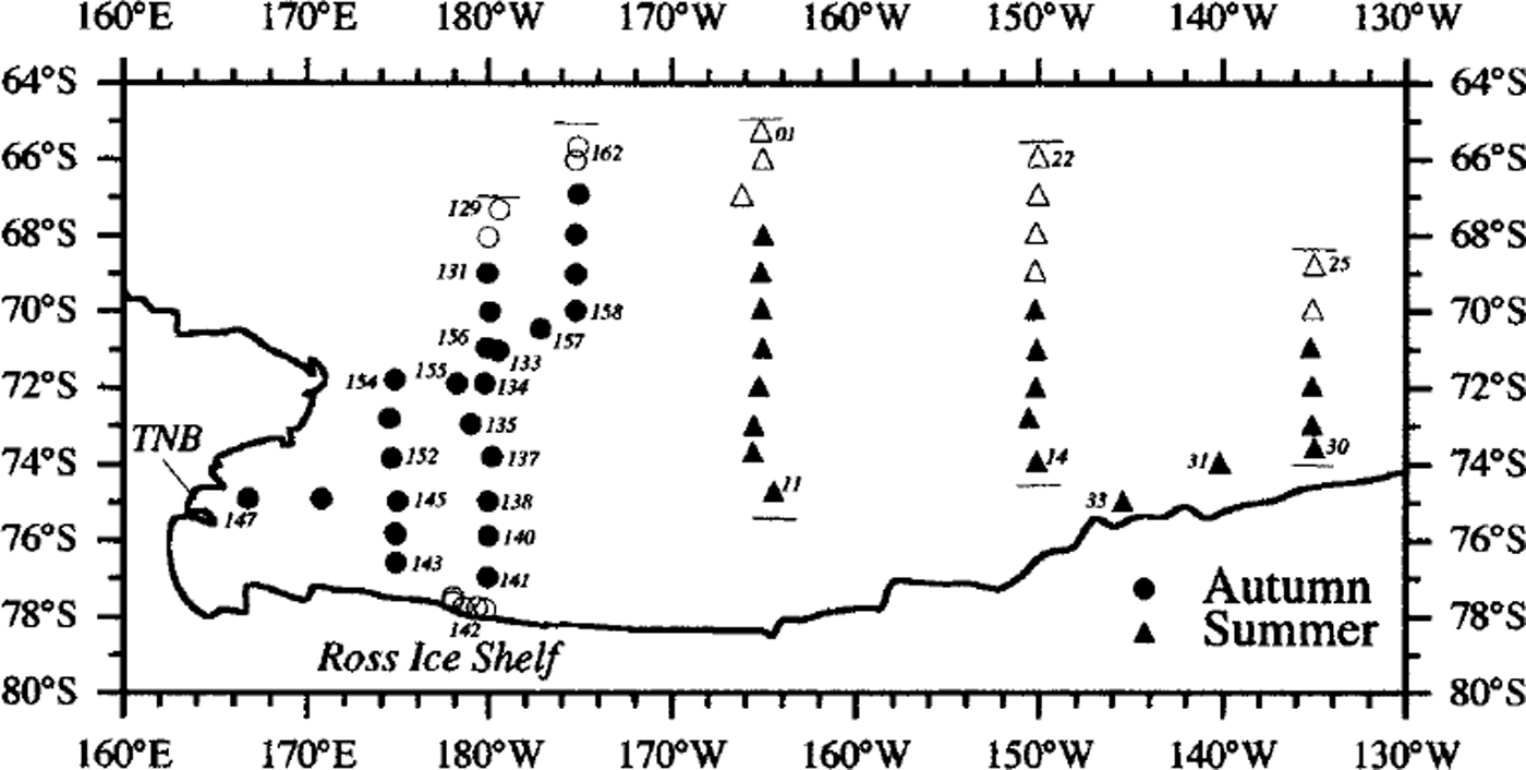
Fig. 1. Map of the cruise tracks for 1998 and 1999. The solid symbols indicate the locations of "full" ice stations. Hollow symbols indicate "basket"stations. Each cruise is divided into three legs. In 1998, there are southbound (days 129−141), northbound (days 142−145 and 152−162) and westbound (days 145−147) legs. In 1999, the legs are along 165° W, 150° Wand 135° W. During the autumn cruise, there were no stations on days 136,139 and 148−151; no snow pits were dug on days 129−130, and only "grab-samples were obtained on days 142−145 There were no stations on days 12−13, 23−24 and 32 during the 1999 cruise. Thin horizontal lines represent ice edges. TNB, Terra Nova Bay.
Two snow-depth datasets, acquired using different methods, were used in this analysis. Regional snow depths were calculated from the so-called Set B data (Reference Worby, Jeffries, Weeks, Morris and JanaWorby and others, 1996). These data were obtained by making 25 estimates each hour, on the hour, of the snow depth and ice thickness of individual floes that were turned on their side by the ship as it moved through the ice. The estimates were made with the aid of a 0.4 m diameter float suspended above the ice at the side of the ship. Since ridges were prone to crumble on impact, the Set B data are more representative of snow depth on "unridged" (level) sea ice. These values were grouped into 1 ° latitude bins for each leg of the cruises.
The more site-specific data were obtained under two scenarios. A"full" station consisted of a 100−150 m long transect laid out on a large ice floe (>200 m across). The snow/ ice interface temperature was determined using a probe at 1m intervals along the line (Reference Sturm, Morris, Massom and JeffriesSturm and others, 1998). The air and snow surface temperatures were measured at the beginning and end of each transect using the same temperature probe. The snow was then removed at 1m intervals, and its depth measured and the ice surface wetness assessed. Holes were drilled through the sea ice in the snow holes, and the freeboard, the height of the ice surface above (+) or below (-) the sea surface, was measured. Multiple snow pits were dug, with at least one snow pit located adjacent to the 100−150 m transect, in the unridged portion of the ice floe. The second station type is the "basket" station, so named in reference to the means of access to the floe. This type of station was necessary when the pack ice consisted primarily of small ( <10 m) floes on which it was not possible to lay out a 100−150 m transect. A single snow pit was examined at each of these stations.
The snow-pit data consist of temperature, visual assessment of wetness, density, salinity, and grain-size and morphology. A total of 42 snow pits on 25 different floes were dug in 1998. Twelve "grab" samples on four floes were also taken: these consisted of a full snow-column sample of unknown volume and were taken because the snow cover was < 0.03 m, i.e. not sufficiently deep for a density sample to be acquired. A total of 46 snow pits on 28 different floes were dug in 1999. Some snow pits had standing water in the bottom of them. Others exhibited discernible "wetting" of the snow at the bottom of the pit, most likely due to brine wicking up into the snow cover when it initially formed. "Wetted" snow appeared dark gray due to a high water content and rounding of the snow grains (Reference Sturm, Morris, Massom and JeffriesSturm and others, 1998), which gave it qualitatively different optical properties from those of dry snow. However, the "wetted" snow retained its structure sufficiently to be sampled using a 0.03 m"LaChapelle"snow cutter with a volume of 105 mm3.
The snow characteristics were obtained from the snow samples removed from the snow-pit wall at 0.03 m intervals using the snow cutter. At each 0.03 m interval, two snow samples were obtained and weighed for density. These samples were then taken aboard the ship, and their grain morphology, size ranges and relative proportions were determined using a microscope. Finally, these samples were melted, their conductivity measured and salinity calculated (Reference BakerBaker, 1987). The salinity data presented in this paper include only dry and "wetted" snow samples, not slush/ standing-water samples.
Snow-Grain Shape and Size Classification
The snow-grain morphology classification used in this study is based on Reference ColbeckGolbeck and others (1990). Single snow grains and composite "grains" (well-bonded chains of grains and clusters) were found in the snowpack in both seasons. Single snow grains comprised only a small part of the snowpack and fell into two categories: recent snow and wet particles. The recent snow particles consisted of precipitation particles (mostly 1c and 1d) and decomposing and fragmented precipitation particles (2a and 2b). Wet particles occurred only in summer. They were found in the "wetted" snow samples and appeared as snow grains surrounded by water, i.e. slush (6c). These grains were either large, well-rounded particles (3b) or very well-bonded and/or eroded melt clusters (6b): due to this ambiguity and their relative scarcity in summer they were classified together. In some samples, which were not thoroughly wetted, the grain morphology was easily identifiable and so the sample was assigned to the appropriate grain type: this was especially true of the autumn samples that were not in near-saturation/disintegration conditions. Grain types also included rounded (3a, 3b, 3c), faceted (4a, 4c) and striates and cups (5a, 5c). A small percentage of snow grains was classified simply as "particles"; these appeared in clusters and chains of grains either by themselves or in combination with other grain types and roughly correspond to very advanced examples of mixed forms of rounded grains (3c) or faceted crystals (4c). Since they had no easily discernible distinguishing characteristics (well-rounded or well-developed faceted) they were classified together. For simplicity, melt clusters and melt-freeze clusters (i.e. 6cl and 6mf: Reference ColbeckColbeck and others, 1990, p. 20), which occurred only in summer, were grouped together.
When appropriate, two ranges of sizes (minimum to maximum) were determined for certain classes of snow grains. First the largest, coherent grain-size range was described; for example, the range of sizes for clusters of rounded particles was estimated. Then, when possible, the range of sizes of the individual grains (rounded particles) was estimated. These are referred to, respectively, as the composite, i.e. cluster, and single grain-sizes. Rather than use an average grain-size for each grain type within the 0.03 m sample, the ranges of minimum and maximum grain-sizes for the single and composite grains are described below. Each 0.03 m snow sample was classified into one of seven grain types based on its dominant grain type (>50%). The depths of the snow pits (excluding standing water) on each cruise were summed (1998 = 5.139 m; 1999 = 10.065 m); then the total depth of each dominant grain type was determined and its percentage contribution to the total snow cover was calculated. If a sample had two dominant grain types (50−50%), half the sample depth, i.e. 15 mm, was assigned to each grain-size type so that the sample depth was not counted twice.
Results
Regional snow-depth variability
The regional distribution of snow depth determined from the Set B data is shown in Figure 2. On average, the snow in summer 1999 was more than three times deeper than in autumn 1998. The snow depths varied by latitude along each leg in autumn (Fig. 2a-c), increasing from the sea-ice edge to the interior pack then decreasing towards the coast. The westbound leg began in the main ice pack, traversed a zone of increased snow depth and ended in the Terra Nova Bay polynya (163.8−165.5° E) where the snow depths (and sea-ice thicknesses) were the thinnest. Snow depths along this leg were generally lower than on the southbound and northbound legs. In summer, snow depths also varied with latitude along each leg, although less systematically than in the autumn (Fig. 2d-f). Along 165° Wand 150° W thinner snow was encountered at the northern and southern ice edges, but along 135° W there was a general increase in snow depth from the northern to the southern ice edge. Taken together, these three legs showed a definite increase in mean snow depth from west (165° W) to east (135° W). The maximum snow depths in Figure 2 show that extreme snow depths were encountered along most of the cruise tracks. The highest maximum snow depths were encountered on sea ice closest to the continent on the 150° Wand 135° W legs in 1999.

Fig. 2. Set b mean snow depths (+1 std dev.) for each latitude bin for each cruise leg in autumn 1998 (a-c) and summer 1999 (d-f). the solid symbols are the maximum snow depth recorded in each bin.
Snow-pit characteristics
Depth and wetness (freeboard)
The depth of each snow pit is shown in Figure 3a and d. All of the snow pits dug in autumn 1998 rested directly on the sea-ice surface, i.e. there was no standing water in the holes, although some exhibited discernible "wetting". Sixteen of the 46 snow pits dug in summer 1999 rested directly on the sea-ice surface; the other 30 had standing water in them (Fig. 3d). Many of these snow pits also exhibited visible "wetting-above the sea-ice surface or the standing-water level. The presence or absence of standing water in the snow pits (Fig. 3a and d) was matched by the wetness appraisals along the 100−150 m transects during the two cruises (Fig. 3c and f).
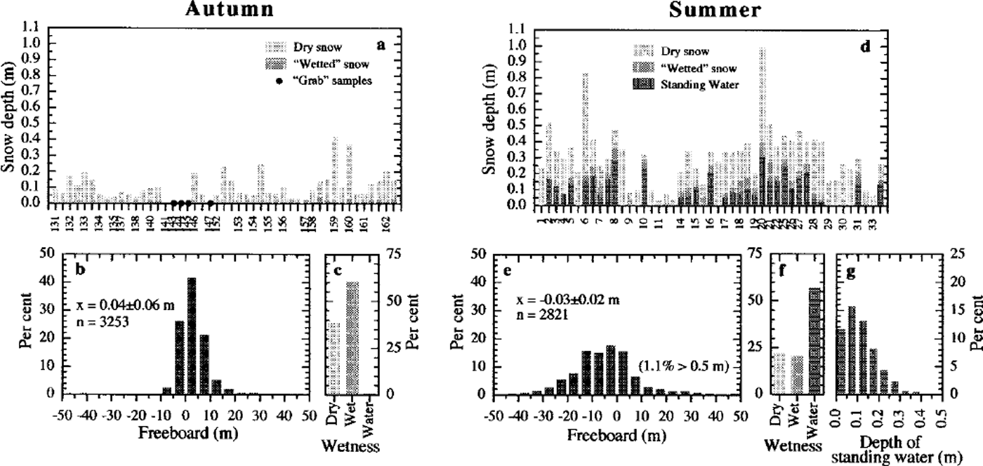
Fig. 3. Summary of the snow fit depth, freeboard and ice surface wetness data for autumn (a-c) and summer (d-g). in (a) and (d) snow depth is represented by the full height of each bar, which is then subdivided to show the proportions of dry and wet snow and standing water. no snow pits were dug on days 143−145 and 147; the solid symbols in (a) are the mean snow depth from the 100−150 m transects. thefrequency ofoccurrence (%) of freeboard values from the 100−150 m transects is shown in (b) and (e); frequency of occurrence (%) of wetness classifications for each snow-depth hole along the transects is shown in (c) and (f); and ( g) is the frequency of occurrence (%) of standing-water depths along the transects in summer.
In autumn 1998, the mean freeboard was 39 ±65 mm, while in summer 1999 it was −30 ±151 mm (Fig. 3b and e), which is indicative of the widespread flooding during this season. In both seasons, the high positive freeboards were located in ridges. Of the 3253 holes drilled in autumn, only 1% had standing water in them before drilling occurred (Fig. 3c); after drilling, 17.5% of the holes were flooded, i.e. freeboards <0mm (Fig. 3b). The autumn 1998 ice cover was cold and relatively impermeable. Consequently, the ice surface was not flooded, even under a sufficiently heavy snow load, except where cracks in the ice (or drillholes) provided a conduit from the ocean to the floe surface. In summer 1999, 57% of the 2821 snow holes had standing water in them before and after drilling (Fig. 3e and f), indicating the free movement of water through the highly permeable summer ice cover. The majority of these flooded summer snow holes (∼90%) had standing water > 0.05 m deep before drilling (Fig. 3g).
Salinity
Overall, the mean snow salinities (±1 std dev.) for the autumn 1998 snow pits (Fig. 4a) were much higher than for the summer 1999 snow pits (Fig. 4d). There was also a greater range of mean values and larger standard deviations in autumn than in summer. In general, the highest salinities were found at the base of the snow column and they decreased with height. In autumn, 28 of the 42 snow pits had high salinities (>l‰) throughout their entire depth, although 82% of these snow pits were <0.1m deep. High salinities were confined to the bottom 0.15 m in 97.6% of the autumn snow pits.
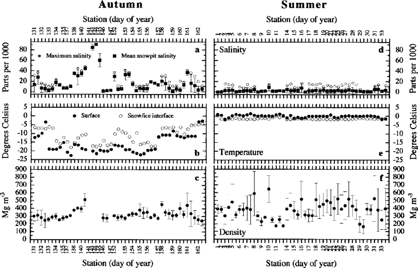
Fig. 4. Summaries of snow-pit data for each season, including: mean snow fit salinity ±1 std dev. and maximum sample salinity (a, d); snow surface and snow/ice interface temperatures (b, e); and mean snow fit density ±1 std dev. (c,f). the salinity values for days 143−145 and 147 are averaged from the "grab" samples acquired on these floes, and the temperature data are averaged from the ice-coring sites on the floes.
Of the 16 snow pits resting directly on the sea ice in summer 1999, four had salinities of < 1‰ throughout their entire depth (0.21−0.34 m). In the other 12 summer snow pits, high salinities were confined to the bottom 0.06 m of the snow column. In the summer snow pits with standing water, the height of the water was measured from the ice surface, and only snow above the water level was sampled. In summer 1999, the standing water in the 30 flooded snow pits (Fig. 3d) had a mean salinity of 28.5 ±2.8‰. These snow pits had high salinities in the bottom 0.09 m of the snow column (above the water line), with lower salinities (<l‰) higher in the snow-pit wall.
The maximum salinity value for each snow pit is also shown in Figure 4a (1998) and d (1999). These values invariably occurred at the bottom of the snow column regardless of whether the snow was resting directly on the sea-ice surface or was "suspended" over standing water.
Temperature
The snow surface and snow/ice interface temperatures for each snow pit are shown in Figure 4b (1998) and e (1999). In autumn 1998, all temperatures were below freezing and the snow surface temperatures were generally lower than the snow/ice interface temperatures. The mean temperature gradient was −63 ±49°C m−1 (ranging from −203 to 34°C m−1), with only three positive temperature gradients.
The snow surface and snow/ice interface temperatures were much higher in summer 1999 than in autumn. The entire summer snow cover was nearly isothermal and close to the melting point, with snow surface temperatures exceeding snow/ice interface temperatures. The mean temperature gradient was 11 ± 12 ˚C m−1 (ranging from −6° to 60˚C m−1), with only three negative temperature gradients.
Density
Mean snow density (±1 std dev.) for each snow pit is shown in Figure 4c (1998) and f (1999). The mean snow densities were higher and more variable in summer 1999 than in autumn 1998. The snow-density values in autumn ranged from 96 to 588 Mg m−3, with 90% at 200−475 Mg m−3. Similar densities have been observed in the autumn and winter snow cover in the Amundsen, Bellingshausen and Weddell seas (Reference Eicken, Lange, Hubberten and WadhamsEicken and others, 1994; Reference Massom, Drinkwater and HaasMassom and others, 1997,Reference Massom, Lytle, Worby and Allison1998; Reference Sturm, Morris, Massom and JeffriesSturm and others, 1998). In summer, the snow densities ranged from 75 to 992 Mg m−3. Eighty per cent of the summer 1999 snow-sample density values were at 200−475 Mg m−3. This was also the range of the majority of snow-density values measured by Reference Jeffries, Veazey, Morris and KrouseJeffries and others (1994) on summer 1992 ice floes in the eastern Ross, Amundsen and Bellingshausen seas. About 16% of the summer 1999 densities were >475 Mgm−3. The higher snow densities and greater variability in summer were due in part to the much higher occurrence of melt clusters and "wetted" snow. Of the 30 summer 1999 snow samples with densities > 500 Mg m−3, 26 were "wetted" from below and 4 contained ice layers. In autumn 1998 only three snow samples had densities > 500 Mg m−3: two were "wetted" from below and one contained ice layers.
Grain morphology and size
Crystal size and morphology are largely a consequence of temperature gradient metamorphism, on the one hand, and melt-freeze cycles, on the other. Given the significantly different temperature gradients in autumn 1998 and summer 1999 snow covers, it is not surprising that these two variables differed greatly between autumn and summer (Fig. 5).
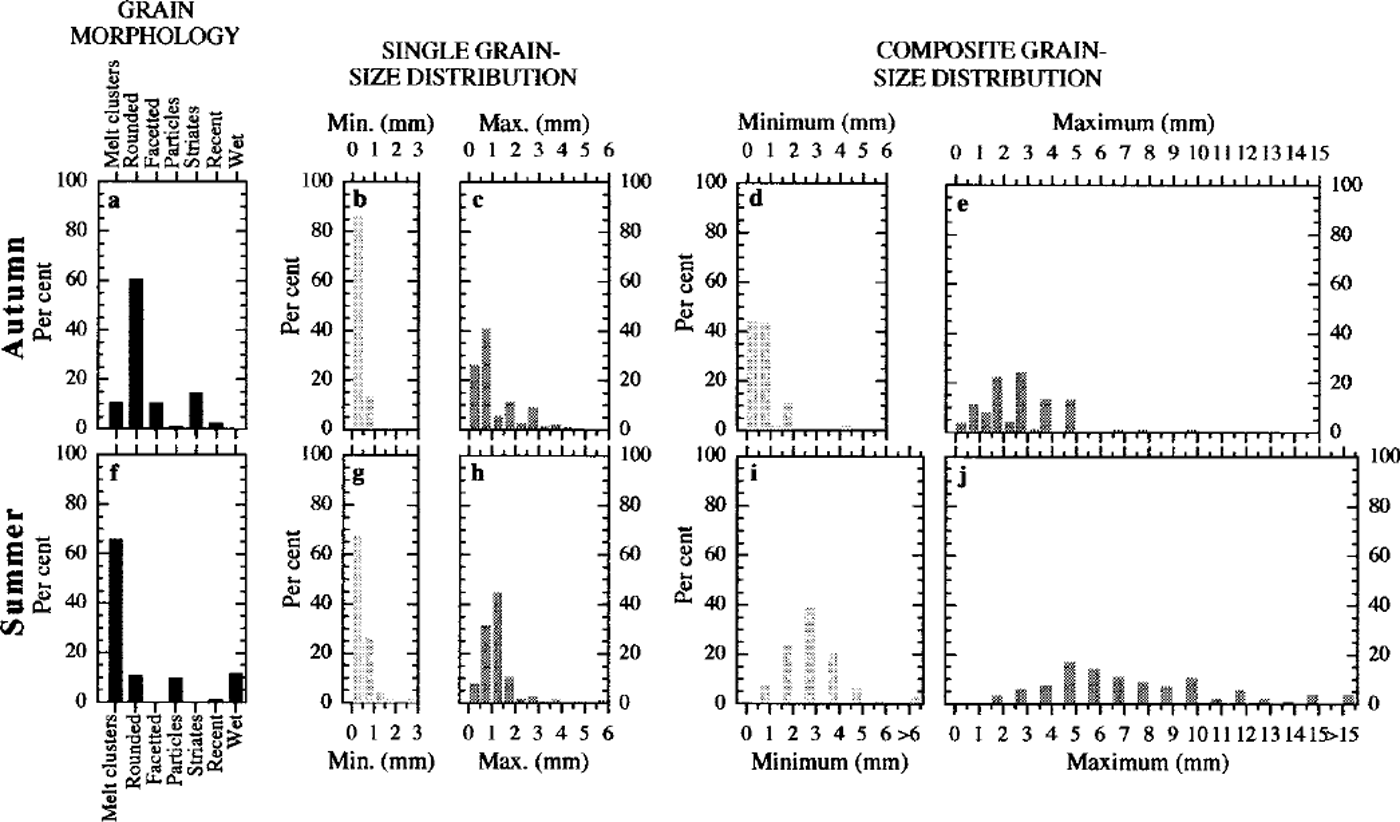
Fig. 5. Summary of snow-grain morphology and size for autumn (a-e) and summer (f-j), including: frequency of occurrence ( % ) of the dominant (>50%) grain morphology categories based on the total depth of snow sampled on each cruise (a,f); and ranges of the minimum and maximum grain-sizes for single grains (b,c,g,h) and composite grains (d, e, i,j).
Rounded particles in clusters and chains of grains completely dominated (60.6%) the autumn 1998 snow cover (Fig. 5a) and dominated the entire depths of 22 snow pits; they showed no preferred location in the other snow pits in which they were found. Melt clusters dominated the entire depths of 13 snow pits, although 12 of these were "grab" samples (<0.03m) which were visibly wetted. Melt clusters also dominated the bottom of nine snow pits. Striates dominated the entire snow column of five pits as a 50−50 mix with another grain type, but otherwise showed no preferential position in the snow pit. Faceted particles dominated two snow pits and were found primarily in the top and middle of the snow pit elsewhere. New-snow and nondescript "particles-comprised only 1−2% of the snow cover. The recent snow was found only on floes in close proximity to the ice edge. The nondescript particles dominated a single snow pit (137_026) and were found nowhere else. None of the autumn samples were classified as wet.
The summer 1999 snow cover was dominated (65.9%) by melt clusters (Fig. 5f). They dominated the entire depth of 13 snow pits, and a further 16 snow pits were composed solely of melt clusters with "wetted" particles at the bottom of the snow column. Elsewhere, melt clusters were found primarily in the top and middle regions of the snow column as were rounded particles. Nondescript "particles" dominated the middle section of some snow pits. Wet particles were found at the bottom of 27 snow pits. Striates were found at the top of two snow pits in a 50−50 mix with another grain type. Recent snow was found at the top of two snow pits on floe 029. None of the summer snow samples were dominated by faceted particles.
In general, the minimum and maximum sizes of the single and composite grains were larger in summer 1999 than in autumn 1998. In both seasons, the dominant minimum sizes for single grains were 0.0−1.0 mm (Fig. 5b and g), although a greater proportion were 0.5−1.0 mm in the summer. The dominant maximum single grain-size in autumn 1998 was 0.0−1.0 mm, while in summer 1999 it was 0.5−1.5 mm, although the percentage of grains exceeding 2.0 mm was nearly three times greater in autumn than in summer (Fig. 5c and h).
Most of the minimum composite grain-sizes were COLO mm in autumn 1998, while in summer 1999 the single highest occurrence of these grains was 2.5−3.0 mm (Fig. 5d and i). In autumn 1998, nearly all of the maximum composite grain-sizes were < 5.0 mm, with a significant portion clustered at 1.5−3.0 mm (Fig. 5e). In summer 1999, these grains covered a much broader range, with a minor concentration at 4.5−6.0 mm (Fig. 5j).
Thaw/freeze features
In autumn 1998, thin (3−7 mm) ice layers were observed in the snow cover, particularly north of 72° S (the outer pack-ice zone). Many of these snow pits also had 1−2 mm icy crusts at the surface. Similar ice layers were found in the snow cover north of 72° S in summer 1999. Much more massive ice layers, on the order of 0.1−0.2 m thick and with a polygonal granular texture (Fig. 6), were observed in the summer snow cover, particularly along the 165° W transect. These ice layers were often located at the bottom of the snow cover, apparently "perched" directly on the water standing on the ice. Where the snow/ice interface was not flooded, polygonal granular ice with the same appearance as that in Figure 6 formed the uppermost layer of some ice cores.

Fig. 6. Thin section of an ice lens, found within the summer snowpack, photographed between crossed polarizers. the section has dimensions of 61mm by 104 mm. photo courtesy oft.kawamura.
Discussion
Autumn 1998 snow cover
The autumn 1998 sea ice was colder and less permeable than in summer 1999, and in some instances there was evidence of active growth at the base of the ice (Jeffries, unpublished data). There was considerably less snow in the autumn than in summer due to the length of accumulation time. The minimal flooding at the autumn snow/ice interface was a consequence of insufficient snow load to depress the floes below sea level. In addition, the low ice temperatures and low brine volume, and thus low permeability, would have precluded substantial movement of sea water/brine through the sea ice to the ice surface via brine channels (Reference Fritsen, Lytle, Ackley and SullivanFritsen and others, 1994). However, wetting did occur at the base of the autumn snow cover as brine wicked up from the sea-ice surface; this was evident from the visibly wetted snow in some of the snow pits (Fig. 3a), and from the elevated salinities at the base of all the snow pits. This phenomenon of high salinity at the base of the snow cover has been observed on pack ice in the Ross, Amundsen and Bellingshausen seas in previous years (Reference Sturm, Morris, Massom and JeffriesSturm and others, 1998) as well as in the Weddell Sea and East Antarctic pack ice (Reference Eicken, Lange, Hubberten and WadhamsEicken and others, 1994; Reference Massom, Drinkwater and HaasMassom and others, 1997,Reference Massom, Lytle, Worby and Allison1998).
The autumn snow cover probably experienced a wide range of temperature gradients during its initial accumulation. However, it is worth noting that the mean temperature gradients for the snow pits examined in 1998 are not significantly different from those for snow pits examined in the Ross Sea in autumn 1995 (Reference Sturm, Morris, Massom and JeffriesSturm and others, 1998). Most of the grains examined on the 1998 autumn cruise were rounded (Fig. 5a) and in chains of grains and clusters with strong bonds. The regional weather alternates between periods that are warm, windy and wet and periods that are clear, cold and relatively calm (Reference Sturm, Morris, Massom and JeffriesSturm and others, 1998). The warm, moist air introduces liquid water into the snow cover (precipitation or melting), producing rounded particles through melting and refreezing. The "wetted" snow base and/or wet ice surface also influences the snow-grain morphology. Liquid water (brine) in the wetted layer causes rounding of the snow grains by melting; when the autumn snow was very thin (<0.05 m), the entire snow column was infiltrated with brine, creating a wet, relatively warm snow cover composed exclusively of melt clusters or rounded particles.
The 1998 snow-cover temperature gradients were sufficient to induce temperature-gradient metamorphism, as indicated by the presence of depth hoar in the snow cover. Although striates and cups dominated only a small portion of the snow cover (Fig. 5a), they were nevertheless very widespread. All of the 22 floes investigated in 1998 had some depth hoar in the snow (44 of 46 snow pits) even if it was only a very small proportion of each snow pit. Twenty-four snow pits exhibited depth hoar throughout the entire snow column; nine snow pits had depth hoar confined to the lower levels and bottom; and four had depth hoar in the surface layer. Reference Fukuzawa and AkitayaFukuzawa and Akitaya (1993) describe a process by which depth hoar grows at or just below the snow surface as a consequence of high temperature gradients developing near the surface after a thin deposition of new snow on an older denser snow. This may partially explain the presence of small amounts of depth hoar throughout the snow column. Each precipitation event may have created a steep surface temperature gradient that led to depth-hoar growth. However, these conditions were most likely short-lived, and the production of depth hoar was small. Each successive snowfall recreated these conditions, and over time the snow cover that accumulated contained a small but prevalent depth-hoar component.
Summer 1999 snow cover
In the summer, both the snow cover and the sea ice were almost isothermal and near the melting point. The sea ice showed signs of melting at the bottom, i.e. scalloping, indicating active melting (Jeffries, unpublished data). The heavier snow load and the higher permeability of the sea ice account for the extensive flooding encountered during the summer cruise.
The dominance of melt/melt-freeze clusters in the summer 1999 snow is a clear indicator of extensive melting and refreezing. Similarly, the presence of ice lenses and pipes indicates that portions of the snow cover became sufficiently wet that downward movement of free water occurred before it froze again. The migration of meltwater through the snow cover would account for the much lower salinities in the summer as the salts would have been flushed to the base of the snow and diluted there.
The very clear, coarse-grained ice layers found at the sea-ice surface or perched immediately above the flooded layer resemble superimposed ice, which occurs on temperate glaciers. Superimposed ice is a consequence of the refreezing of meltwater that has percolated through the snow cover onto the ice below (Reference KoernerKoerner, 1970) and is indicative of a snow environment in an advanced stage of melting. Such superimposed ice has been identified by Reference Kawamura, Ohshima, Takizawa and UshioKawamura and others (1997) in Lützow-Holm Bay, Antarctica, and by Reference Jeffries, Worby, Morris and WeeksJeffries and others (1997) in the Bellingshausen Sea pack ice. We are not aware of any previous observations of "perched" superimposed ice layers, which must form as the less dense snow meltwater pools and freezes on top of the cold (<1.5°C), saline sea water at the flooded snow/ice interface.
Despite the extensive melting within the snowpack, there were no signs of melt ponds or bare ice during the summer cruise. Reference Andreas and AckleyAndreas and Ackley (1982) hypothesized that the low relative humidity, estimated as 60%, was largely responsible for the lack of melt-pond formation on Antarctic sea ice because this condition required higher air temperatures (≥0.8°C) to initiate melting. The mean relative humidity during the summer 1999 cruise was 84.3 ±8.4%. Following the assumptions of Reference Andreas and AckleyAndreas and Ackley (1982), and adopting a relative humidity of 80%, snowmelt would be initiated at air temperatures of-0.2° to −1.0°C. These temperatures were typical during the summer cruise (mean −2.0 ±2.0°C). However, they did not persist long enough to produce melt ponds, in contrast to summer 1995 in the Weddell Sea where surface ponding was observed (Drinkwater and others, 1999).
Conclusions
This description of the basic physical characteristics of the autumn 1998 and summer 1999 snow shows that the snow cover is a complex and evolving layer on the surface of Antarctic ice floes. The autumn snow in 1998 was thin, with very little flooding at the snow/ice interface. Nevertheless, many snow pits had visible wetting and high salinities at their bases attributable to brine wicking up into the snow cover from the sea-ice surface. The snow was dominated by rounded grains in well-bonded clusters and chains of grains, implying that the snow temperatures had fluctuated considerably and that steep temperature gradients did not persist long enough for significant depth-hoar formation.
The summer 1999 snow cover was significantly different from the autumn snow cover. The summer snow cover was deeper than in autumn and had undergone extensive flooding. It is apparent that the summer snow was subject to thaw/freeze cycles. During the thaw phase, there was advanced melting and desalination of the snow. The freeze phase resulted in a snow cover dominated by melt clusters; it also contained ice lenses, pipes and superimposed ice. The thaw phases were too short for the snow to melt completely and create melt ponds. If the warming trend in the vicinity of the Antarctic Peninsula (e.g. Reference Drinkwater, Liu, Low and WadhamsDrinkwater and others, 1998) expands into other areas, perhaps melt ponds will become more widespread with potentially significant consequences for the sea-ice cover.
Acknowledgements
This research was supported by U.S. National Science Foundation grants OPP9316767 and OPP9614844 and NASA grant PP0008. We would like to thank D. Naber and C. Li for their assistance with the snow-pit analysis, the science team and volunteers who helped acquire the transect and Set B data, and T. Kawamura (Institute of Low Temperature Science, Hokkaido University, Japan) for the use of the photograph in Figure 6. We would also like to acknowledge Captain J. Borkowski, III, the officers and crew of the R/V nathaniel b. palmer and the Antarctic Support Associates personnel who made invaluable contributions to this research. This paper benefited from the comments of A. Hachikubo and one anonymous reviewer.


