Introduction
Following earlier work in 1965–67 (Reference Troitskiy, Singer, Koryakin, Markin and MikhalyevTroitskiy and others 1975), a detailed study of glaciation on Spitsbergen was conducted using geophysical and geochemical methods, and deep‐core thermal drilling.
Investigations of ice thickness and of subglacial relief were particularly important tasks. Before 1974 such data were available for Van Keulenfjorden, Kongsfjorden, and Nordaustlandet (Reference Husebye, S¢rnes and WilhelmsenHusebye and others 1965, Reference OelsnerOelsner 1966, Reference EkmanEkman 1971).The data for Nordaustlandet were obtained by seismic reflection shooting and, for the two other regions, from gravity observations of rather lower precision. Radio echo‐sounding techniques were used, which have proved to be successful for the investigation of cold ice sheets in Antarctica, Greenland, and the Arctic (Reference BogorodskiyBogorodskiy 1975).
Radio echo‐sounding of glaciers on Spitsbergen was conducted during the summer field seasons of 1974–75 and 1977–79 from helicopters and some results have already been published (Reference MacheretMacheret 1976[a) andReference MacheretMacheret 1976[b]), Reference Macheret and ZhuravlevMacheret and Zhuravlev 1980, Reference Kotlyakov, Macheret, Gordiyenko and ZhuravlevKotlyakov and others 1980, Reference Macheret and ZhuravlevMacheret and Zhuravlev 1980).Measurements were carried out on 87 glaciers including tributary glaciers of various types in the western, north‐western, north‐eastern, and south‐western parts of Spitsbergen and in the west of Nordaustlandet (Fig.l). Total length of profiles of airborne radio echosounding covered about 2 000 km. Approximately 75% of the glaciers investigated terminated in the sea
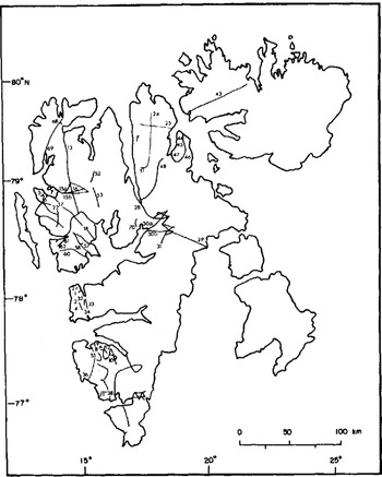
Fig.1 Radio echo‐sounding of glaciers in Spitsbergen during 1974‐75 and 1977‐79. Lines indicate radio echo‐sounding routes
-
1: Aldegondabreen
-
2: V∅ringbreen
-
3: Dahlfonna
-
4: Erdmannbreen
-
5: Vestre Br∅ggerbreen,
-
6: Austre Br∅ggerbreen
-
7: Midre Lovenbreen
-
8: Antoniabreen
-
9: Hessbreen
-
10:Penckbreen, with tributaries Suesbreen and Tirolarbreen
-
12:Finsterwa1derbreen with tributaries Revtannbreen (west), and Leinbreen and Marjelbreen (east)
-
13: Monacobreen
-
15a: Kongsbreen
-
15.bKronebreen
-
16.Holtedahlfonna
-
17.Kongsvegen
-
18.Sveabreen
-
22.Uversbreen
-
24.Åsgårdfonna
-
25.Valhallfonna
-
28.Mittag‐ Lefflerbreen
-
29.Negri breen,
-
30a.Nordenskiö1dbreen (north)
-
30b.Nordenskiöldbreen (south)
-
31 Tunabreen
-
32 Vestre Gr∅nfjordbreen
-
33 Austre Gr∅nfjordbreen,
-
34 Fridtjovbreen
-
35 Recherchebreen
-
36 Vestre Tore11breen
-
38: Hansbreen
-
43: Vestfonna (Nordaustlandet),
-
44: Odinj∅kelen,
-
45: Torsfonna
-
46: Balderfonna
-
47: Kantbreen
-
48: Veteranen
-
51: Gjallarbreen
-
52: E1nabreen
-
53: Orsabreen
-
57: Wahlenbergbreen
-
58: Borebreen
-
60: Eidembreen
-
61: Lovliebreen
-
68: Raudfjordbreen
-
69: Lilliehookbreen
-
70: Bertilbreen
-
71: Werenskioldbreen
Field Measurements And Results
During the first two field seasons, a radio altimeter (PV‐17) with a carrier frequency of 440 MHz was used. Later an instrument (RLS‐620) with a carrier frequency of 620 MHz was employed, which had been specially designed (Reference Macheret and ZhuravlevMacheret and Zhuravlev 1980 , Reference ZhuravlevVasilenko and others 1980). During the first season, an antenna with a wide polar diagram was used (about 100° at the half‐power point), whereas, in the second season, a special 16‐element antenna grid with a narrow diagram (about 18°) was constructed and used. Signals were recorded by a uniformly moving 35‐mm film across an oscilloscope screen operating in the “E” mode.
Radio echo‐sounding from helicopters was usually carried out along the longitudinal axis of glaciers. Flight altitude over the surface of a glacier was 100 to 300 m, the flight speed was 80 to 200 km h-1. Navigation was accomplished visually with the help of landmarks, typically the ends and fronts of glaciers, moraines, nunataks, etc. Repeated radio echo‐soundings along the same routes, and also flights over glaciers where land radio echo‐sounding measurements had been conducted (e.g. Austre Gr∅nfjordbreen, Fridtjovbreen, Austre Br∅ggerbreen, V∅ringbreen), were carried out to evaluate navigational accuracy which was usually found to be good. Differences in ice thickness on 8 glaciers up to 12.5 km long investigated in detail in the western part of Spitsbergen did not exceed 60 m, and the thickness difference was, on average, equal to 10 to 30 m (Reference Macheret and ZhuravlevMacheret and Zhuravlev 1980). The error of radio echo‐sounding measurements compared with data from thermal coring on the ice shed between Austre Gr∅nfjordbreen and Fridtjovbreen to a depth of 211 m was about 4%. The mean velocity of propagation of electromagnetic waves in the glacier was 168 mμs-l
Satisfactory results using the PV‐17 system were obtained only in mountain regions, where ice thicknesses, as a rule, did not exceed 200 m. In other regions reflections from the bed at depths over 150 to 250 m were often intermittent hampering simple interpretation. On some glaciers internal radio‐echo reflections were observed at depths of 70 to 180 m (Reference Macheret and ZhuravlevMacheret and Zhuravlev 1980).
The use of RLS‐620 apparatus made it possible to sound glaciers 2 to 3 times deeper than with the PV‐17 equipment (the maximum depth of ice measured was 540 m) and obtain records. An example of an RLS‐620 recording on Recherchebreen‐Vestre Torellbreen and on Veteranen is given in Figure 2
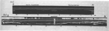
Fig.2 .Radio echo‐sounding record of Recherchebreen‐Vestre Torellbreen (top) and Veteranen (bottom). T is transmitter pulse, S is ice surface reflection, S2 and S3 are multiple reflections from the glacier surface, B is bed reflection, S+B are over‐reflections from the surface and the bed of a glacier, solid vertical lines denote reference points, dotted vertical lines denote range scales: the calibration pips are 0.5 μs apart: Distance between adjacent range scales is 1 min
Some of the results of airborne radio echo‐sounding may now be summarized. Most of the glaciers sounded (≈ 85%) gave continuous bed reflections over 40 to 100% of their length. Some 10% of the glaciers gave echoes over 5 to 20% of their length near the blade, near the border, or close to nunataks, but signals disappeared in the accumulation area and ice divides of the glaciers. Accumulation areas of some of the larger glacier systems (e.g. Isachsenfonna in Haakon VII Land) and Amundsenisen, Vrangpeisbreen, H∅gstebreen, Dobrowolskibreen, and Ljosfonna in the southern part of Spitsbergen gave only very discontinuous results.
The most probable causes for loss of bed reflections are: (i) scattering of electromagnetic waves from cracks and inhomogeneities in the snow‐firn layer (e.g. ice lenses and water inclusions); (ii) losses in wet snow and firn, as well as in the layer of water on the surface of the glacier; (iii) small ice thicknesses (i.e. below the resolution capacity of the sounder: 45 to 65 m in the ice); (iv) low reflection coefficient at the glacier bed due to roughness; and (v) iarge bed slopes prevent resolution beyond the critical angle
It should be expected that scattering or attenuation will be greatest in temperate ice with snow and firn during tne ablation period and possessin9 a large number of ice lenses in the firn layer. Good examples of the occurrence of such phenomena are Isachsenfonna, areas in the western part of Nordenskiold Land and parts of south Spitsbergen (Reference Troitskiy, Singer, Koryakin, Markin and MikhalyevTroitskiy and others 1975). Only glaciers where subglacial reflections exceed 40% will be regarded.
Results of radio echo‐sounding of these glaciers are given in Figures 3 4 5 6The method of building up profiles of glaciers along the flight routes has been reported in detail elsewhere (Reference Berikashvili and MacheretBerikashvili and Macheret 1980;Reference Macheret and ZhuravlevMacheret and Zhuravlev 1980). Topographic maps of the Norsk Polarinstitutt of scales 1:100 000 and 1:500 000 were used for profile construction. Heights of glacier fronts terminating in the sea were taken as 20 to 30 m.
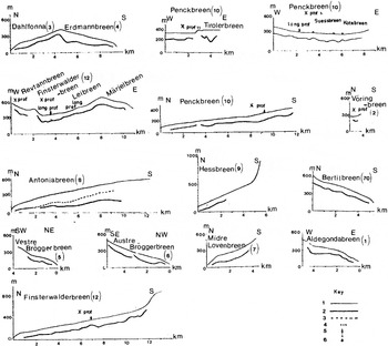
Fig.3 Reduced profiles of some mountain glaciers in Spitsbergen from radio echo‐sounding. 1 is glacier surface, 2‘and 3 are glacier bed and internal reflecting horizons, 4 is moraine, 5 is thermodrilling site, 6 is glacier bed from seismic shooting by Swedish expedition in 1958(Reference EkmanEkman 1971).
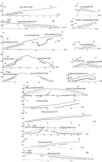
Fig.4 . Profiles of glaciers in western, north‐western, and south‐western Spitsbergen from radio echo‐sounding. Key as in Figures 3.
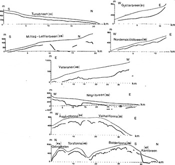
Fig.5 Profiles of the glaciers in north‐eastern Spitsbergen from radio echo‐sounding. Key as in Figures 3.
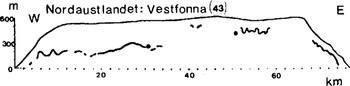
Fig.6 Profile across Vestfonna, Nordaustlandet from radio echo‐sounding. Key as in Figure 3
Discussion
Profiles of some mountain glaciers are represented in Figures 3. These glaciers, as a rule, are < 165 m thick, have overdeepened sections, and exhibit bed irregularities up to 100 m. The maximum ice thicknesses of Erdmannbreen, Tirolarbreen, and Antoniabreen are 210, 220, and 350 m, respectively. Hessbreen, which possesses a relatively smooth bed, is an exception. Most glacier termini are gently sloping but some (e.g. Austre Br∅ggerbreen, Midre Lovénbreen, Erdmannbreen) have been formed by buried terminal moraines which testifies to previous advances. Longitudinal profiles of Dahlfonna and Erdmannbreen are asymmetric in character: Erdmannbreen is large and has a substantial thickness of ice. It is worthwhile to point out that on Penckbreen areas in the vicinity of the middle moraine coincide with small bedrock highs.
Figures 4and5show profiles of other typical valley glaciers, with plateaux and their outlet glaciers
The Austre Gr∅nfjordbreen‐Fridtjovbreen system occupies a valley divided by a subice high of≈200 m elevation. This “subglacial water interfluve” is displaced somewhat north compared to the ice divide. In addition the bed of Fridtjovbreen lies near or somewhat lower than sea‐level for a distance of several kilometres. The Recherche breen‐Vestre Torellbreen system is up to 430 m thick and occupies a through valley, the bottom of which lies below sea‐level. It is only in the region of the ice divide, near nunataks, that the bed rises above sea‐level (200 m a.s.l .). Dome‐shaped bedrock surfaces characterized the fronts of Fridtjovbreen and Vestre Torellbreen. The thickness of Werenskioldbreen in its upper overdeepened part reaches 320 m, but is separated from its lower portion by a subglacial ledge of ≈ 100 m height. The thickness of the middle part of Hansbreen also exceeds 300 m.
In Oskar II Land Wahlenbergbreen, Borebreen, Eidembreen, and also Uversbreen, flowing from L∅venskioldfonna, have thickness values up to 195 m and rather even bed morphologies, almost parallel to the ice surface. The ice divides of these glaciers lie at a height of almost 600 m a.s.l. The thicknesses of L∅vliebreen and Vestgotabreen do not exceed 165 m; their longitudinal profiles are almost symmetrical
Quite different glacial characteristics are found in the north‐western part of Spitsbergen. Here systems of glaciers have comparatively high ice divides: ≈ 750 m a.s.l. on Kongsvegen Sveabreen and Raudfjordbreen‐ Lilliehöökbreen, and almost 850 m a.s.l. on Monacobreen Kronebreen. Thickness of these glaciers, judging from the data available, does not exceed 200 to 250 m, and their subglacial relief is rather even. On Kronebreen and Holtedahlfonna, however, two depressions in the bed have been discovered, with the ice reaching 440 m in thickness, (i.e. exceeding the “background” thickness by 200 to 300 m). Elnabreen and Orsabreen (outlet glaciers of Holtedahlfonna) have ice up to 180 and 315 m thick, with subglacial relief variations not exceeding 40 to 50 m.
Depressions in the bed have also been discovered on Mittag‐Lefflerbreen and Negribreen flowing out of Lomonosovfonna. Here thicknesses of ice reach 540 and 385 m, exceeding the “background” by 300 to 400 m.
Other outlet glaciers of Lomonosovfonna, namely, Tunabreen and Nordenskiöldbreen, have rather smooth subglacial relief and thicknesses up to 165 m. To the north‐east of Lomonosovfonna, Veteranen, one of the deepest glaciers in Spitsbergen, is located. Its thickness in the middle part reaches 500 m.
Åsgårdfonna, adjacent Valhallfonna, and numerous outlet glaciers, and Odinj∅kelen, Torsfonna, and Balderfonna with outlet Kantbreen (Fig.5) are typical of another group of glaciers. Radio echo‐sounding indicates that subglacial relief in the centre of Åsgårdfonna and Balderfonna is very rugged, ice thickness values vary from 100 m to 330 or 350 m over several kilometres. Thicknesses of Kantbreen in the northern part of Balderfonna, and Gjallarbreen on the west of Åsgårdfonna, reach 330 and 310 m respectively. Their subglacial beds are overdeepened by up to 100 m. On the other hand, rather smooth subglacial relief is found on Odinj∅kelen and Torsfonna. Ice thickness values here are 120 to 215 m. It is suggested that differences in character of subglacial relief under ice caps are controlled by the geological and tectonic structure of Ny Friesland
Subglacial relief of Vestfonna, Nordaustlandet, is very rough in coastal areas and is rather smooth in the central part of the dome where the ice thickness reaches 385 m (Fig.6).It should be noted that results of radio echo‐sounding correspond closely with data obtained from seismic measurements carried out by the Swedish expedition of 1958 (Reference EkmanEkman 1971)
On the basis of radio echo‐sounding data it is possible to note a regular northward decrease in ice thickness in the western part of Spitsbergen and thinning westward in the northern part. This is evidently associated with the prevailing direction of air masses carrying moisture, and with corresponding reduction in precipitation and accumulation. Geological and tectonic factors are also important. Some of the glaciers investigated (Fridtjovbreen, Recherchebreen‐Vestre Torellbreen, Antoniabreen, Werenskioldbreen, Negribreen) exhibit internal reflecting horizons. According to some data, parts of these glaciers (Fridtjovbreen, Recherchebreen, Negribreen) are surging.
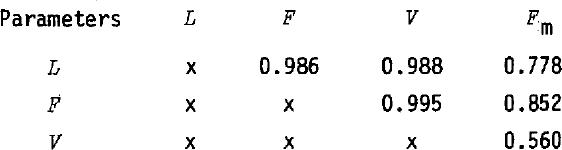
We have tried to analyse the interrelationships of length L, area F, and volume V of those parts of glaciers free from moraine with the areas of terminal and lateral moraines Fm. Volumes of some glaciers have been taken from the work ofReference Zhuravlev Zhuravlev (1980). The volumes of some glaciers have been determined using an empirical relationship derived by Zhuravlev
Volumes, lengths, and areas of 14 glaciers, together with the areas of their terminal and lateral moraines Fm, are given in Table I.Table II presents the results of multiple regression analysis betweenV, L, F, and Fmfor the 14 glaciers listed in Table I. The areas of terminal and lateral moraines Fm, as a rule, increase with the length, area, and volume of glaciers. Closer interrelations exist among parameters L, F, and F m.Greatest deviations are found for Antoniabreen and Veteranen, which are some of the deepest valley glaciers. There is poor correlation between V and Fm, but even in this case a general tendency of Fm to increase withV is observed. Other factors, apparently, are also important for processes forming glacier moraine deposits. These are oscillation and movement of glaciers, ice‐flow conditions, intensity of ablation‐accumulation processes, and the rate of advance of glaciers.
Table I Length L, Area F, Volume V and the Area of the Terminal and Lateral Moraines Fm of certain Glaciers in Spitsbergen
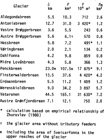
Table II Correlation Coefficient between Length L, Surface Area F, Ice Volume V and Area of Glacier Moraines Fm for some Spitsbergen Glaciers (see Table I)